|
*N/B The reforms to Local Development Contributions have a cap of $20,000 per residential lot or per dwelling limitation on local
development contributions
The
contribution is also partly based on 251sqm and the current rate of $139.26
per sqm of additional commercial floor space which is a total of $34,961.80.
Reason: Statutory requirement.
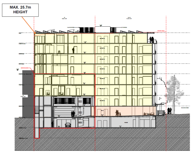
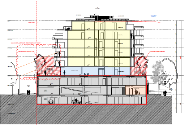
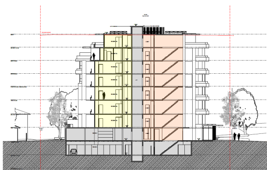
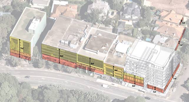
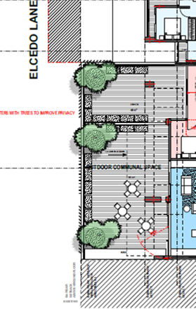
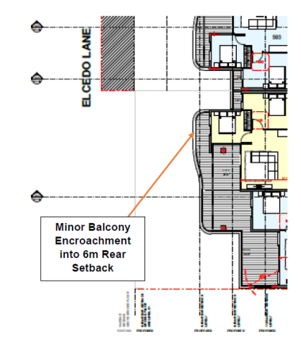
4. Design Amendments A
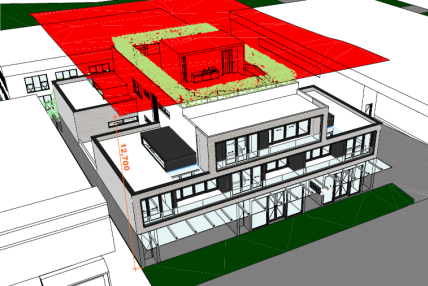
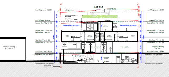
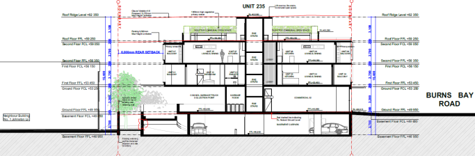
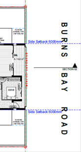
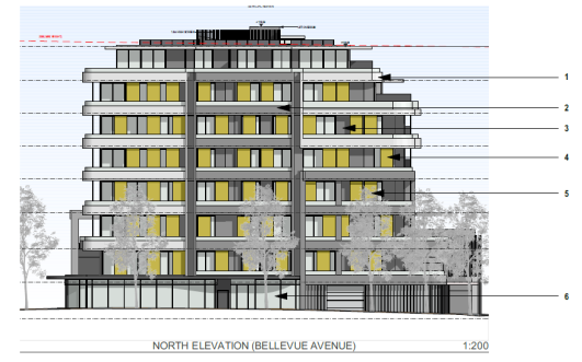
minimum 6m balcony setback is to be achieved to the western elevation
adjoining Elcedo Lane on Levels 5 and 6. Further, the design of the
internal/external common open space area on Level 2 are to be reversed with
Units 204 and 205.
Reason: To ensure adverse privacy
impacts are minimised.
5. Design
Verification. Prior to the relevant Construction Certificate being issued with
respect to this development, the Principal Certifying Authority is to be
provided with a written Design Verification from a qualified designer. This
statement must include verification from the designer that the plans and
specification achieve or improve the design quality of the development to
which this consent relates, having regard to the design quality principles
set out in Part 2 of State Environmental Planning
Policy No. 65 – Design Quality of Residential Flat Development. This condition is imposed in accordance with Clause 143 of the Environmental Planning and Assessment Regulation 2000.
Reason: Statutory
requirement.
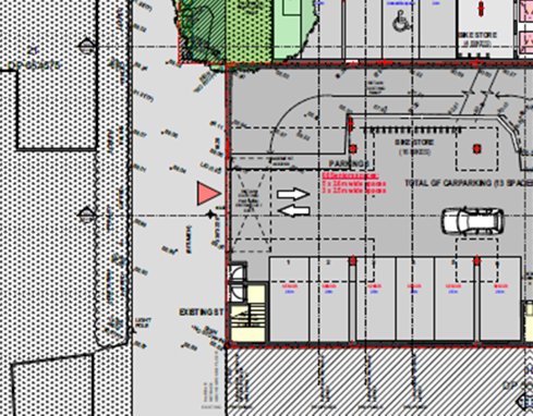
6. Parking
Allocation Both the owner and occupier of the development and/or the
strata body must provide and maintain the minimum parking allocation as
follows;
1. 48 senior’s residential spaces
including three accessible and carwash bay space;
2. Four commercial spaces including one
accessible space;
3. Two motorbike spaces on the
commercial car parking level;
4. Four bicycle racks on the commercial
car parking level; and
5. One bicycle rack at the entrance of
each commercial tenancy.
Reason: To ensure parking spaces are provided in accordance with
the determination
7. Crime Prevention Through Environmental Design: Compliance with the following
Crime Prevention Through Environmental Design requirements:
· The building address is to be cleared identified with signage
visible from the street;
· An electronic surveillance system (CCTV) is to be included to
provide surveillance of areas of the building including entry/exits, mail
boxes and garage areas particularly bicycle and motorcycle parking areas and
storage cages. The system is to be capable of recording high-quality images
of events. The recording equipment is to be locked away to reduce the
likelihood of tampering. Monitors should be placed in secure areas, to allow
security staff, if applicable, to view all areas under camera surveillance;
· Appropriate signage is to be erected inside and around the
perimeter of the property to warn of security treatments in place e.g.
“This site is under 24 hour video surveillance”;
· Lighting in and around the common areas of the development should
comply with Australian Standard 1158 and provide for adequate, uniform
illumination. External lighting should be of a ‘white light’
source. Luminaries (light covers) are to be installed throughout all common
area lighting to reduce opportunities for malicious damage;
· An emergency control and evacuation plan should be implemented
within the building;
· All recording made by the CCTV system must be stored for at least
30 days and ensure that the system is accessible by at least one member of
staff (or authorised resident) at all times it is in operation, and provide
any recordings made by the system to a police officer or police inspector
within 24 hours of any request made by those persons;
· Mailboxes should be secured so they are entirely within the
building lobby or only able to be opened from inside the building (or behind
a secured common area). Australia Post requirements prevail where there is
any inconsistency; and
· Suitable warning signs are to be erected within the basement
parking area warning residents of theft of bicycles, motorcycles and from
storage cages.
8. Transport
for NSW Conditions.
1. All buildings and structures, together with any
improvements integral to the future use of the site are to be wholly within
the freehold property (unlimited in height or depth), along the Pacific
Highway boundary.
2. Detailed design plans and hydraulic calculations of any changes to the
stormwater drainage system that impact upon the Pacific Highway are to be
submitted to TfNSW for approval, prior to the commencement of any works.
Please send all documentation to development.sydney@transport.nsw.gov.au. A
plan checking fee will be payable and a performance bond may be required
before TfNSW approval is issued.
3. The developer is to submit design drawings and documents relating to the
excavation of the site and support structures to TfNSW for assessment, in
accordance with Technical Direction GTD2020/001. The developer is to submit
all documentation at least six weeks prior to commencement of construction
and is to meet the full cost of the assessment by TfNSW. Please send all
documentation to development.sydney@transport.nsw.gov.au If it is necessary
to excavate below the level of the base of the footings of the adjoining
roadways, the person acting on the consent shall ensure that the owner/s of
the roadway is/are given at least seven-day notice of the intention to
excavate below the base of the footings. The notice is to include complete
details of the work.
4. All demolition and construction vehicles are to access the site via
Bellevue Avenue. A construction zone will not be permitted on the Pacific
Highway.
5. The proposed development, noting its partial use of a senior’s
living development, is to be designed, as per the requirements of State
Environmental Planning Policy (Transport & Infrastructure) 2021 such that
it includes measures to ameliorate potential traffic noise or vehicle
emissions noise within the site of the development arising from the Pacific
Highway. These measures shall be certified by an appropriately qualified
noise and air quality expert and noted on the plans prior to issue of a
Construction Certificate.
Reason: TfNSW Condition.
9. Restriction
on Persons Accommodated. The development may only be for the
accommodation of the following only –
- Seniors or people who have a disability,
A restriction as to user is to be registered against the title of
the property to which this consent relates prior to the issue of an
Occupation Certificate, in accordance with Section 88E of the
Conveyancing Act 1919, limiting use of any accommodation to the kinds of
people referred to above. The restriction as to user is to include the
definition of seniors and people with a disability contained
within SEPP (Housing for Seniors or People with a Disability) 2004.
Reason: Statutory requirement
10. Accessible
Design Compliance with Schedule 3 of SEPP (Housing for Seniors or People
with a Disability) 2004, as referenced in the submitted Access Report is to
be detailed in the construction level architectural drawings, and certified
by a suitably qualified access consultant, prior to issue of a Construction
Certificate for below ground building works.
Reason:
Statutory requirement.
11. Ground
Level Commercial Floor Area Occupation and fitout of the ground floor
commercial floor area approved by this consent is subject to separate
approval.
Reason:
To ensure an adequate assessment of any commercial usage is undertaken.
BUILDING CONDITIONS
12. Cladding
and glazing No external
combustible cladding is permitted on the building. The ground floor commercial glazing facing Burns Bay Road is
to be clear for the life of the development to ensure an appropriate level of
street activation and passive surveillance is achieved.
Reason:
To promote safety and street activation.
13. Payment
of building and construction industry long service levy
Before the issue
of a construction certificate, the applicant is to ensure
that the person liable pays
the long service levy based on $ 2,490,273.00
cost of works as calculated at the
date of this consent to the Long Service Corporation or Council under section 34 of the Building
and Construction Industry Long Service Payments Act 1986 and provides proof of this payment
to the certifier.
Reason: To ensure the long service
levy is paid.
14. Asbestos removal,
handling and disposal
The removal, handling and disposal of asbestos from
building sites shall be carried out in accordance with the requirements of
the Occupational Health and Safety Act and the Regulations. Details of the
method of removal in accordance with this condition is to be submitted to the
Principal Certifying Authority and Council’s Environmental Health
Section, prior to commencing any demolition works.
Reason: To ensure worker and public
health and safety.
15. Construction site
management plan
Prior
to any demolition works and before the issue of a construction certificate,
the applicant must ensure a construction
site management plan is prepared before it is provided to and approved by the certifier. The plan must include the following matters:
· location
and materials for protective fencing and hoardings to the perimeter on the site.
· For
sites adjoining bushland a 1.8m chain mesh perimeter fence with 1m sediment
fencing attached to the lower portion is required to ensure that no foreign
materials enter the bushland.
· provisions for public safety
· pedestrian and
vehicular site access
points and construction activity zones
· details
of construction traffic management, including proposed truck movements to and from the site and
estimated frequency of those movements,
and measures to preserve pedestrian safety in the vicinity of the site. The
construction traffic management plan shall comply with the requirements of
Part R of Lane Cove DCP 2010 and shall be submitted to Council’s
Traffic Section for written approval. Consultation with NSW Police, TfNSW,
and Sydney Buses may be required. Note: Heavy vehicles are not permitted to
travel on local roads without Council approval.
· protective
measures for on-site tree preservation (including in accordance with AS 4970-2009 Protection of trees on
development sites and Council’s DCP,
if applicable) and trees
in adjoining public
domain (if applicable)
· For
major works, appointment of a project arborist of minimum AQF Level 5
qualification to oversee/monitor tree(s) condition during the construction
process.
· details of any bulk
earthworks to be carried out
· location of site storage
areas and sheds
· equipment used
to carry out all
works
· a garbage container with a tight-fitting lid
· dust, noise
and vibration control
measures including a construction noise management plan prepared in
accordance with the NSW EPA’s Interim Construction Noise Management
Guidelines by an appropriately qualified acoustic consultant.
· location of temporary toilets.
· The
applicant must ensure a copy of the approved construction site management plan
is kept on-site at all times
during construction.
Council Approvals
1. Hoarding is required to be provided along the street frontages, a
Hoarding Application is to be submitted to Council for approval.
2. Any construction plant on the public road reservation requires an
approved “Application for standing plant
permit”.
Additional
Council Requirements
1. Stockpiles
or soil shall not be located on / near any drainage lines or easements,
natural watercourses or water bodies, footpath or roadway without first
providing suitable protective measures adequate to protect these water
bodies.
2. All
stockpiles of contaminated materials must be stored in an environmentally
sensitive manner in a secure area on the site and shall be suitably covered
to prevent dust and odour nuisance.
3. All
stockpiles of potentially contaminated soil must be assessed in accordance
with relevant NSW Environment Protection Authority guidelines, including NSW
EPA Waste Classification Guidelines (2014).
4. Where sites
adjoin bushland:
- For sites identified to be within
bushfire prone land An Asset Protection Zone (APZ) shall be provided entirely
within the site boundary. To protect bushland and property from fire risk,
APZ standards are to be in accordance with Planning for Bushfire Protection
(PBP) 2019.
- Access to the site from adjacent
parks/reserves/bushland for the purposes of carrying out building works,
landscaping works, storage materials, storage of soil or rubbish is not
permitted.
Reason: To require details of measures
that will protect the public, and the surrounding environment, during site works and construction.
16. Erosion and sediment
control plan
Prior
to any demolition works or clearing of any vegetation and before the issue of
a construction certificate, the applicant is to
ensure that an erosion and sediment control plan is prepared in accordance with the following documents before it
is provided to and approved by the certifier:
· Council’s development control plan,
· the
guidelines set out in the NSW Department of Housing manual ‘Managing Urban Stormwater: Soils
and Construction Certificate’ (the Blue Book), and
· the ‘Do it Right On-Site, Soil and Water
Management for the Construction Industry' (Southern Sydney Regional
Organisation of Councils and the Natural Heritage Trust).
The
applicant must ensure the erosion and sediment control plan is kept on- site
at all times
during site works and construction.
Reason: To ensure no substance other than rainwater enters
the stormwater system and
waterways.
17. Waste
management plan (WMP)
Before
the issue of a construction certificate, the applicant is to ensure that a waste management plan is prepared
in accordance with the EPA’s Waste Classification
Guidelines and the following requirements before it is provided to and approved by the certifier:
a) Council’s Development Control Plan (Part
Q: Waste Management and Minimisation).
b) Where
sites adjoin bushland (private or public):
- the
WMP shall detail measures to mitigate any rubbish or foreign materials from
entering the bushland.
- Access
through parks, reserves and bushland to the site is not permitted.
- Council’s
Coordinator of Bushland must be notified of any accidental or intentional
dumping of material in the bushland area.
c) details
the following:
- the contact details of the person(s)
removing the waste
- an
estimate of the waste (type and quantity) and whether the waste is expected
to be reused, recycled or go to landfill
- the
disposal and destination of all waste material spoil and excavated material
The
applicant must ensure the waste management plan is referred to in the
construction site management plan and kept on-site at all times during
construction.
Reason: To ensure resource recovery is promoted and local amenity protected during construction.
18. Utilities and services
Before
the issue of the relevant construction certificate, the applicant must submit the following written evidence of
service provider requirements to the certifier:
a) a
letter of consent from all utility and service providers demonstrating that satisfactory arrangements can be made
for the installation and supply of electricity.
b) a
response from Sydney Water as to whether the
plans proposed to accompany the application for a construction
certificate would affect any Sydney Water infrastructure, and whether
further requirements need to be met.
c) other
relevant utilities or services - that the development as proposed to be
carried out is satisfactory to those other service providers, or if it is
not, what changes are required to make the development satisfactory to them.
Reason:
To ensure relevant utility
and service providers requirements are provided to the certifier.
19. Dilapidation
report
Before
the issue of a construction certificate, a suitably qualified engineer must prepare a dilapidation report
detailing the structural condition of adjoining
buildings, structures or works, trees to be retained and public land, to the
satisfaction of the certifier. If
the engineer is denied access to any adjoining properties to prepare the dilapidation report, the
report must be based on a survey of what
can be observed externally and demonstrate, in writing, to the
certifier’s satisfaction that
all reasonable steps were taken to obtain access to the adjoining properties.
Reason: To
establish and document the structural condition of adjoining properties and public land for comparison
as building work progresses and is completed.
20. Structural
engineer’s details
The
Construction Certificate plans and specifications must include detailed
professional structural engineering plans and/or specifications for the
following:
· underpinning;
· retaining walls;
· footings;
· reinforced concrete work;
· structural steelwork;
· upper level floor framing;
and
where relevant in accordance with any recommendations contained in an
approved geotechnical report.
Reason: To ensure structural adequacy.
21. Sydney
Water requirements
The
approved plans must be submitted to Sydney Water online approval portal
“Sydney Water Tap In” for approval. A section 73 certificate is
to be obtained for development or subdivision requiring servicing of sewer
and water.
Reason: To comply Sydney Water requirements.
22. Signs
on site
A sign
must be erected in a prominent position on any site on which building work or demolition work
is being carried out:
a) showing the name, address
and telephone number
of the principal certifier for the work, and
b) showing
the name of the principal contractor (if any) for any building work and a telephone number on which that
person may be contacted outside working hours,
and
c) stating that
unauthorised entry to the work site is prohibited.
Any such sign is to be maintained while the
building work or demolition work is
being carried out but must be removed when the work has been completed.
Note:
This does not apply in relation to building work
or demolition work that is carried
out inside an existing building that does not affect the external walls of the
building.
Reason: Prescribed condition
EP&A Regulation, clauses
98A (2) and (3).
23.
Compliance with Home Building Act
In
the case of residential building work for which the Home Building Act 1989 requires there to be a contract of
insurance in force in accordance with Part 6
of that Act, that such a contract of insurance is in force before any
building work authorised to be
carried out by the consent commences.
Reason: Prescribed condition EP&A Regulation,
clause 98(1)(b).
24. Hours
of work
All
demolition, building construction work, including earthworks, deliveries of
building materials to and from the site to be restricted as follows:-
Monday to Friday (inclusive) 7am
to 5.30pm
High
noise generating activities, including rock breaking and saw cutting be
restricted between 8am to 5.00pm with a respite period between 12.00 noon to
1.30pm Monday to Friday
Saturday 8am
to 12 noon
with
NO high noise generating activities, including excavation, haulage truck
movement, rock picking, sawing, jack hammering or pile driving to be
undertaken. Failure to fully comply will result in the issue of a breach of
consent P.I.N.
A
Notice/Sign showing permitted working hours and types of work permitted
during those hours, including the applicant’s phone number, project
manager or site foreman, shall be displayed at the front of the site.
The
principal certifier must ensure building work, demolition or vegetation
removal is not carried out on Sundays and public holidays, except where there
is an emergency.
Unless
otherwise approved within a construction site management plan, construction vehicles, machinery, goods
or materials must not be delivered to the site
outside the approved hours of site works.
Note: Any variation to the hours
of work requires Council’s approval.
Reason: To protect the amenity of the surrounding area.
25. Compliance
with the Building Code of Australia
Building
work must be carried out in accordance with the requirements of the Building Code
of Australia.
Reason: Prescribed condition -
EP&A Regulation clause 98(1)(a).
26. Procedure
for critical stage inspections -
While
building work is being carried out, any such work must not continue after
each critical stage
inspection unless the principal certifier is satisfied the
work may proceed in accordance with this consent and the relevant construction certificate.
Reason: To
require approval to proceed with building work following
each critical stage inspection.
27. Surveys
by a registered surveyor -
While
building work is being carried out, a registered surveyor is to measure and mark the positions of the
following and provide them to the principal
certifier —
a) All footings/ foundations
b) At
other stages of construction – any marks that are required by the principal certifier.
Reason: To ensure buildings are
sited and positioned in the approved location.
28. Shoring
and adequacy of adjoining property
If
the development involves any excavation that extends below the level of the base of the footings of a building,
structure or work on adjoining land (including
any structure or work within a road or rail corridor), the person having the benefit of the development
consent must, at the person’s own expense
—
a) Protect and
support the building, structure or work
from possible damage from the excavation, and
b) Where
necessary, underpin the building, structure or work to prevent any such
damage.
This
condition does not apply if the person having the benefit of the development consent owns the adjoining land
or the owner
of the adjoining land has given consent in writing to that
condition not applying.
Reason: Prescribed condition -
EP&A Regulation clause
98E.
29. No
obstruction of public way
The
public way must not be obstructed by any materials, vehicles, refuse, skips
or the like, under any circumstances. Non-compliance with this requirement
will result in the issue of a notice by Council to stop all work on site.
Reason: To ensure public safety.
30. Encroachments
1. No portion of the proposed structure shall encroach onto the
adjoining properties.
2. The proposed construction shall not encroach onto any existing
Council stormwater line or drainage easement unless approved by Council.
3. No
encroachment is to occur into public open space.
Reason: To ensure works are contained wholly within the subject site
31. Post-construction
dilapidation report
Before the issue
of an occupation certificate, a suitably qualified engineer must prepare a post-construction
dilapidation report, to the satisfaction of the principal certifier,
detailing whether:
a) after
comparing the pre-construction dilapidation report to the post- construction dilapidation report
required under this condition, there has been any structural damage to any adjoining buildings; and
b) where
there has been structural damage to any adjoining buildings, that it is
a result of the building work
approved under this
development consent.
Before
the issue of an occupation certificate, the principal certifier is to provide a copy of the post-construction
dilapidation report to Council (where Council
is not the principal certifier) and to the relevant adjoining property owner(s).
Reason: To
identify damage to adjoining properties
resulting from building
work on the development site.
32. Sydney
Water requirements
A
section 73 certificate is to be obtained for development or subdivision
requiring servicing of sewer and water.
Reason: Sydney Water requirement.
33. Annual
fire safety certificate
During
occupation and ongoing use of the building, the applicant must provide
an annual fire
safety statement to Council and the Commissioner of Fire and Rescue NSW in accordance with clause 177 of the
EP&A Regulation.
Reason: To
satisfy Council’s Engineering requirements to ensure annual checks on
fire safety measures.
34.
Implementation of BASIX commitments
While building work is being carried out, the applicant must
undertake the development strictly in accordance with the commitments listed
in the BASIX certificate(s) approved by this consent, for the development to
which the consent applies.
Reason: To ensure BASIX commitments
are fulfilled in accordance with the BASIX certificate (prescribed condition
under clause 97A(2) EP&A Regulation).
35. Property Numbering
Prior
to registration of any strata plan, submit to Council for approval a schedule
of unit numbers against lot numbers.
Reason: To ensure the numbering system is
in accordance with Australian Standard AS/NZS 4819:2011, and the NSW
Address Policy and User Manual.
36.
Lot Consolidation and Strata
Subdivision
All lots subject to this consent are to be consolidated into a single
allotment and the strata subdivision registered prior to the issue of
any Occupation Certificate.
Reason: To ensure the development occurs in
accordance with the consent.
37. 88B
Instrument: An instrument under 88B of the Conveyancing Act 1919
plus two copies is to be submitted to Council prior to the release of
subdivision certificate. The 88B instrument shall properly reflect the
requirements of the conditions of the development consent, plans forming part
of the consent and Council’s policies.
Where Council, interallotment drainage lines or services are
located within the development, drainage easements and easements for services
shall be created in accordance with Council’s minimum widths as set out
in Council’s DCP-Stormwater Management.
Part 2 of the 88B instrument shall contain a provision that any
easements, rights of way, covenants shall not be extinguished or altered
without the written consent of Council.
38. Linen Plan of Subdivision:
A Linen Plan of Subdivision plus five copies are to be submitted to Council prior
to the release of subdivision certificate.
The linen plan of subdivision shall be suitable for endorsement by
the general manager pursuant to Section 327 of the local government act and
shall properly reflect the requirements of the conditions of the development
consent, plans forming part of the consent and Council’s policies.
General Engineering Conditions
40. Design and
Construction Standards: All engineering plans and work shall be
carried out
in accordance with Council’s standards and relevant development control
plans except as
amended by other conditions.
Reason: To ensure all works are in accordance with
Council’s requirements
41. Materials
on Roads and Footpaths: Where the applicant requires the use of Council
land for placement of
building waste, skips or storing materials a “Building waste
containers or materials in a public place” application form
is to be lodged. Council land is not to be occupied or used for storage
until such application is approved.
Reason: To ensure public safety and amenity
42. Works
on Council Property: Separate
application shall be made to Council's Urban Services Division for approval
to complete, any associated works on Council property. This shall
include hoarding applications, vehicular crossings, footpaths, drainage
works, kerb and guttering, brick paving, restorations and any
miscellaneous works. Applications shall be submitted prior to the
start of any works on Council property.
Reason: To
ensure public works are
carried out in accordance with Council’s requirements
43. Permit
to Stand Plant: Where the
applicant requires the use of construction plant on the public road
reservation, an “Application for Standing Plant Permit” shall be made to Council. Applications shall be submitted and approved prior
to the start of any related works. Note: allow 4 working days for
approval.
Reason: To ensure public safety
44. Restoration:
Public areas must be maintained in a safe condition always. Restoration
of disturbed Council land and assets is the responsibility of the
applicant. All costs associated with restoration of public land will be
borne by the applicant.
Reason: To maintain Council infrastructure
45. Public
Utility Relocation: If any
public services are to be adjusted, because of the development, the applicant
is to arrange with the relevant public utility authority the alteration
or removal of those affected services. All costs associated with the relocation
or removal of services shall be borne by the applicant.
Reason: To protect, maintain and provide utility
services
46. Pedestrian
Access Maintained: Pedestrian access, including disabled and pram access,
is to be maintained throughout the course of the construction as per
AS-1742.3, ’Part 3 – Traffic control devices for works
on roads’.
Reason: To ensure pedestrian
access is maintained
47. Council
Drainage Infrastructure: The proposed construction shall not encroach onto any existing
Council stormwater line or drainage easement unless approved by Council. If a
Council stormwater line is located on the property during construction,
Council is to be immediately notified. Where necessary the stormwater
line is to be reconstructed or relocated to be clear of the proposed
building works. Developer must lodge Stormwater Inspection Application form
to Council. All costs associated with the reconstruction or relocation
of the stormwater line are to be borne by the applicant. Applicant is not
permitted to carry out any works on existing Council and private stormwater pipe lines
without Council’s approval.
Reason: To protect public
infrastructure
48. Services: Prior to excavation works, the location and depth of
all services must be ascertained. All costs associated with adjustment of the
public utility will be borne by the applicant.
Reason: To protect and maintain infrastructure assets
49. Boundary
Levels: The levels of the
street alignment shall be obtained from Council. These levels are to be
incorporated into the design of the internal pavements, car parking,
landscaping, driveway and stormwater drainage plans and shall be obtained prior
to the issue of the Construction Certificate. Note: The finished floor
level of the proposed garage or carport shall be determined by Council.
Applicant has to
lodge Vehicular Crossing Application form with application fee as shown in
the form.
Reason: To provide consistent
street alignment levels
Engineering conditions to be complied with prior to
Construction Certificate
50. Council
Infrastructure Damage Bond: The
applicant shall lodge with Council a $20000 cash bond or bank
guarantee. The bond is to cover the repair of damage to Council's roads,
footpaths, kerb and gutter, drainage or other assets because of the
development. The bond will be released upon issuing of the Occupation
Certificate. If Council determines that damage has occurred because of the
development, the applicant will be required to repair the damage. Repairs are
to be carried out within 14 days from the notice. All repairs are to be
carried in accordance with Council’s requirements. The full bond will
be retained if Council’s requirements are not satisfied. Lodgement of
this bond is required prior to the issue of the Construction Certificate.
Reason: To protect and maintain public
infrastructure
51. Drainage
Plans Amendments: The stormwater drainage plan prepared by ING
Consulting Engineers Pty Ltd, reference No: 326092021DA, issue A and
dated on 11 October 21 is to be amended as detailed below by a
qualified practising hydraulic engineer and certified by him/her. This
amended plan shall show full details of new pipe network amended as follows
and satisfying part O of the Council’s stormwater DCP;
1. This
DA requires OSD. The detailed design for this proposed system is required
2. Proposed
drainage system should show pipe sizes and invert levels up to connection
point; confirming pipe system satisfies part O of Council’ storm water
DCP.
3. Clean
out pits are required at all low points of charged drainage line if charged
pipe system is proposed.
4. Sediment
control fence shall be placed around the construction site and shown in plan
5. Stormwater
runoff from driveway shall be collected by grated driveway pit and connected
to stormwater system
6. Minimum
of 1.8m height difference is required between start and end of the charged
pipe system as per section 5.1 in Council DCP. The details of design level
difference shall be shown in plan.
7. The
stormwater connection pipe from fence line to proposed pit shall be designed
for gravity discharge only and no charged pipe line allowed.
8. A
gross pollutant trap suitable for this site needs to be designed and added to
the amended plans within the property boundary prior to the connection to the
street system. The details of this GPT shall be shown in stormwater plan. The
suitable access to the GPT for future maintenance is required.
9. The
OSD calculation shall be based on the calculation shown in Appendix 14 in
part O of Council stormwater DCP.
10. The detailed
cross section of the OSD is required and shall show levels, sizes, depths and
widths.
11. Overflow from
the OSD shall not re-enter the site via proposed driveway and must be
directed to an acceptable stormwater system.
12. By considering
all these issues, Council recommends improving existing pipe system in
Bellevue Avenue satisfying Council’s Stormwater DCP to accommodate
future stormwater from this proposal. The applicant shall install one kerb
inlet pit on lower point at right corner of the site and extend the pipe
system to this pit from existing Council’s street drainage system.
13. Council will
not support any pit where the flow direction changes more than 90 degree.
14. A plan with
longitudinal section of the proposed pipe system from the site to the
existing Council pit with relevant calculations are required for further
assessment and/or approval. This plan should show pipe sizes, invert levels
and existing surface levels to confirm that the pipe system satisfies
Council’s DCP.
15. The pump out system in basement shall satisfy
section 5.4 of part O of Council’s stormwater DCP. The full details of
the hydraulic calculation for pump out system shall be included in stormwater
management plan submitted to Council.
16. The proposed basement shall be constructed
with water-proof walls around it.
17. Installation
pipe system near the protected trees must be assessed by Council Tree
Officer.
The
amended design is to be certified that it fully complies with, AS-3500 and
Part O, Council's DCP-Stormwater
management; certification is to be by a suitably qualified engineer. The
amended plan and certification shall be submitted to the Principal Certifying
Authority prior to the issue of the Construction Certificate.
The Principal Certifying Authority is to be
satisfied that the amendments have been made in accordance with the
conditional requirements and the amended plans are adequate for the purposes
of construction. They are to determine what details, if any, are to be added
to the construction certificate plans, for the issue of the Construction
Certificate.
Reason: To ensure the proposed stormwater designs meet and
satisfy Part O, Council DCP
52. Construction
Methodology Report: There are structures on neighbouring properties that
are deemed to be in the zone of influence of the proposed excavations. A
suitably qualified engineer must prepare a Construction Methodology report
demonstrating that the proposed excavation will have no adverse impact on any
surrounding property and infrastructure. The report must be submitted to
Principal Certifying Authority prior to issue of a Construction
Certificate.
The Report must include recommendations of
improvement works on adjoining street on appropriate construction techniques
to ameliorate any potential adverse impacts.
The development works are to be undertaken in
accordance with the recommendations of the Construction Methodology report.
Reason: To protect neighbouring properties
53. Road
Dilapidation Survey: The applicant is to prepare a dilapidation survey
and a dilapidation report that includes details of the existing state of
repair/condition of the road surface of Bellevue Avenue, Elcedo Lane and
Pacific Highway and provide that survey and report to the Council and RMS
prior to the issue of the construction certificate. Following completion of
construction of the development and prior to the issue of the occupation
certificate, the applicant is to prepare a second dilapidation report that
includes details of all changes and damage caused to the surface of the said
public roads as a consequence truck movements associated with construction of
the development. The Council/TfNSW may apply funds from the security deposits
paid in favour of this consent to meet the cost of making good any damage
caused to the surface of the said public road as a consequence of truck
movements associated with the construction of the development to which the
consent relates.
The dilapidation surveys and reports must be prepared by
an engineer registered with the Institute of Engineers (Australia).
Reason: To provide a record of Council’s infrastructure and
protect them
54. Council
Construction Requirements: The
applicant shall construct/reconstruct the following to Council’s
satisfaction;
1. New
footpath adjacent the entire frontage of the site to Council’s
satisfaction
2. New
Kerb and Gutter along the entire frontage of the site to Council’s
satisfaction
3. Construction
of new street drainage system along Bellevue Ave
4. Reinstate
all adjustments to the road surfaces.
5. Reinstate
all existing nature-strips with turf and soil on road reserve.
6. Reinstate
all damages identified in dilapidation report
Reason: In accordance with
Council’s requirements to restore site
A $40000 cash bond or bank guarantee shall be
lodged with Council to cover the satisfactory construction of the above
requirements. Lodgement of this bond is required prior to the issue of the
Construction Certificate. The Bond will be held for a period of six
months after satisfactory completion of the works. All works shall be carried
out prior to the issue of the Occupation Certificate. All costs
associated with the construction of the above works are to be borne by the
applicant.
Reason: In accordance with
Council’s requirements to restore site
55. Council
Inspection Requirements: The following items are to be inspected
· Proposed drainage construction on Bellevue Ave
· All footpath, kerb/gutter and landscaping
works
· Any adjustment works in Council road
reserve
Each item is to be inspected prior
to the pouring of any concrete (formwork) and on completion of the
construction. An initial site meeting is to be conducted with council and the
contractor prior to the commencement of any of the above works to allow for
discussion of Council construction / set out requirements.
An Inspection fee ($205 for one
inspection) is to be paid prior to the issue of the Construction
Certificate.
Reason:
To ensure completion of work satisfying Council
56.
Positive Covenant Bond: The applicant shall lodge with Council a $1000.00 cash bond to
cover the registration of a Positive Covenant over the onsite
detention system. Lodgement of this bond is required prior to
the issue of the Construction Certificate
Reason: To protect stormwater infrastructure and
confirm future maintenance
57.
On-Site Stormwater Detention System - Marker Plate: The on-site detention system shall
be indicated on the site by fixing a marker plate. This plate is to be of
minimum size: 100mm x 75mm and is to be made from non-corrosive metal
or 4mm thick laminated plastic. It is to be fixed in a prominent
position to the nearest concrete or permanent surface or accessgrate. The
wording on the marker plate is described in Council’s DCP-Stormwater
management. An approved plate may be purchased from Council's customer
service desk.
Reason: To ensure clear identification of onsite
stormwater infrastructure
58.
On-Site Stormwater Detention Tank: All access grates to the onsite
stormwater detention tank are to be hinged and fitted with a
locking bolt. Any tank greater than 1.2 m in depth must be fitted with step
irons.
Reason: To prevent unauthorised access and ensure safe
access to stormwater infrastructure
59 Rainwater
Reuse Tanks: The proposed
rainwater tank is to be installed in accordance with Council’s
rainwater tank policy and relevant Australian standards.
Note:
§ Rainwater
draining to the reuse tank is to drain from the roof surfaces only. No
“on - ground” surfaces are to drain to the reuse tank.
“On - ground” surfaces are to drain via a separate system.
§ Mosquito
protection & first flush device shall be fitted to the reuse tank.
§ The overflow
from the rainwater reuse tank is to drain to the receiving system.
§ Installation
of rainwater tank shall be accordance with section O6 of part O of Council
DCP.
§ Hydraulic
calculation prepared by qualified engineer for charged pipe system draining
to rainwater tank and submitted to Council
§ This tank
shall have effective volume as mentioned in plan, with 100mm air gap on top
and 100mm sludge zone at the bottom
Reason: To comply with
Council’s requirements and satisfy hydraulically
60. Proposed Vehicular Crossing: The proposed vehicular crossing shall be
constructed to the specifications and levels issued by Council. The
driveway opening width includes wings along at the face of kerb is to satisfy all requirements and conditions
given by Traffic Section of Lane Cove Council, in the interest of pedestrian safety. The driveway
shall be 300mm away from existing power pole and existing stormwater
pit. This driveway is to be designed to stop road runoff entering the
property, to be certified that it fully complies with AS 2890 Series and
Council's standards and specifications
and constructed in accordance with AS 2890.1.2004 “Off
Street Car Parking”.
The following plans shall be prepared and
certified by a suitably qualified engineer demonstrating:
- Longitudinal section along the
extreme wheel paths of the driveway/access ramp at a scale of 1:20
demonstrating compliance with the scaping provisions of AS2890.1. It shall
include all levels and grades, including those levels stipulated at boundary
levels, both existing and proposed from the centre line of the roadway
through to the parking area clearly demonstrated that the driveway complies
with Australian Standards 2890.1-2004 “Off Street Car Parking”.
This is to address the following;
a. Transitional
grades in accordance with AS2890 to be provided.
b. If
a gradient in excess of 25% is proposed, the engineer must certify that this
design is safe and environmentally sustainable.
- Sections showing the clearance to the
underside of any overhead structure demonstrating compliance with the
clearance provisions of AS2890.1.
- An analysis of
vehicle maneuvering is required to confirm vehicle movement is safe in the
proposed parking area.
A ‘Construction of Residential
Vehicular Footpath Crossing’ application, design and certification
shall be submitted to the Principal Certifying Authority prior to the
issue of the Construction Certificate. All works associated with the
construction of the crossing shall be completed prior to the issue of the
Occupation Certificate.
Reason: To ensure compliance with Australian Standards
and Council’s standards
61. Temporary
Footpath Crossing: A temporary footpath crossing must be provided
at the Vehicular access points. It is to be 1.5m in width, made of sections
of hardwood with chamfered ends and strapped with hoop iron.
Reason: To ensure safety vehicular movement to and
from site
62. Splay
of Front Fence: The front fence is to have a 1x1m splay on both sides of
the driveway to maintain pedestrian sight lines. Plans showing this amendment
to the proposed design are to be submitted to the Principal Certifying
Authority prior to the issue of the Construction Certificate;
all associated works are to be completed prior to the issue of the
Occupation Certificate.
Reason: To ensure good visibility
Engineering condition to be complied during construction
63. Drainage
Construction: The stormwater drainage on the site is to be constructed
generally in accordance with approved plan
Certification by a suitably qualified engineer
of the above plans is to be submitted to the Principal Certifying Authority
stating that the design fully complies with, AS-3500 and Part O,
Council's DCP-Stormwater Management. The
plans and certification shall be submitted prior to the issue of the
Construction Certificate.
The Principal Certifying Authority is to
satisfy themselves of the adequacy of the certified plans for the purposes of
construction. They are to determine what details, if any, are to be added to
the Construction Certificate plans, for the issue of the Construction
Certificate.
Reason: To maintain the stormwater management of the property
64. Heavy Vehicle Duty
Employee and Truck Cleanliness: The applicant shall
· Inform in writing all contractors of
Council’s requirements relating to truck cleanliness leaving the site.
· Keep a register of all contactors that have
been notified, the register is to be signed by each contractor. The register
must be available for access by Council officers at all times.
· Place an employee within close proximity of
the site exit during site operation hours to ensure that all outgoing heavy
vehicles comply with Council’s requirements. This employee shall liaise
with heavy vehicle drivers and provide regular written updates to drivers on
the conditions of entry to the subject site.
Those drivers
who have been determined to continually not comply with Council’s
requirements, either by the developer or authorised Council officers, shall
not be permitted re-entry into the site for the duration of the project.
Reason: To protect the environment
65.
Covering Heavy Vehicle Loads: All vehicles transporting soil material
to or from the subject site shall ensure that the entire load is
covered by means of a tarpaulin or similar material. The vehicle driver
shall be responsible for ensuring that dust or dirt particles are not
deposited onto the roadway during transit. It is a requirement under the
Protection of the Environment Operations (Waste) Regulation, 1996 to ensure
that all loads are adequately covered, and this shall be strictly enforced by
Council’s ordinance inspectors. Any breach of this legislation is
subject to a “Penalty Infringement Notice” being issued to
the drivers of those vehicles not in compliance with the regulations.
Reason: To ensure worksite pollutions are controlled
accordingly to protect the environment
66. Truck
Shaker: A truck shaker ramp must be provided at the construction
exit point. Fences are to be erected to ensure vehicles cannot bypass
the truck shaker. Sediment tracked onto the public roadway by vehicles
leaving the subject site is to be swept up immediately.
Reason: To
protect the environment
Engineering condition to be complied with prior to
Occupation Certificate
67. Certification of
Existing Structures and Excavations: A suitably qualified
structural engineer shall provide
certification to the principal certifying authority that all
existing structures are structurally satisfactory for proposed
development and retaining structures and excavations have been carried
out in accordance with the relevant Australian Standards and Codes of
Practice.
The certification and a complete record of
inspections, testing and monitoring (with certifications) must be submitted
to the principal certifying authority prior to the issue of the Occupation
Certificate.
Reason: To ensure retaining walls are constructed
according to approved plan
68. Stormwater
System Engineering Certification: On completion of the drainage system
a suitably qualified engineer shall certify that the drainage system
has been constructed in accordance with the approved plans, part O
Council’s DCP-Stormwater Management and AS-3500.The certification is to
include a work as executed plan. The work as executed plan shall:
(a) Be signed by a registered surveyor, &
(b) Clearly show the surveyor’s name and the
date of signature.
All documentation is to be submitted to the
Principle Certifying Authority prior to the issue of the Occupation
Certificate.
Reason: To ensure stormwater infrastructure has been
installed in accordance with Australian Standards and Council’s
requirements
69.
Engineering Certification: A suitably qualified engineer shall certify that
following has been constructed in accordance with the approved
plans and is within acceptable construction tolerances.
· Pump out system
· Rainwater tank
· New pipe system in Bellevue Ave
Certification is to be
submitted to the Principle Certifying Authority prior to the issue of the
Occupation Certificate.
Reason: Statutory requirement
70. Positive
Covenants OSD and Pump Out System: Documents giving effect to the
creation of a positive covenants over the on-site detention system and
over the basement pump out system shall be registered on the title of
the property prior to the issue of the Occupation Certificate. The
wordings of the terms of the positive covenants shall be in accordance
with part O Council’s DCP-Stormwater Management.
Reason: Statutory requirements and to protect
stormwater infrastructure and confirm future maintenance
71. Works
as Executed Drawings for OSD: A works as executed survey of the
onsite detention facility will need to be prepared and certified to
demonstrate that the OSD system functions as per the intention of the
approved design. A suitably qualified engineer must certify that the
construction system is satisfactory.
Reason: Statutory requirements
72. Works
as Executed Drawings for street drainage construction: A works as
executed survey of the proposed street drainage works on Orion Rd will
need to be prepared and certified by qualified engineer to demonstrate that
the drainage system is accordance with the approved plan.
Reason: Statutory
requirements
73. Redundant
Gutter Crossing: All redundant kerb/gutter and footpath crossings
shall be removed, and the kerb, gutter and footpath reinstated to the
satisfaction of Council’s Urban Services Division. These works
shall be carried out prior to the issue of the Occupation
Certificate.
Reason: To ensure Council’s footpath and nature
strip is free from potential vehicular or other obstructions.
Traffic Conditions
Parking and
servicing
74. The proposed car park
design is to comply with AS290.1-2004. This includes all parking
Spaces, ramps, aisles, disabled parking and loading areas. All other aspects
of the car parking areas are required to comply with AS2890.2-2002 for
Loading Facilities and Services Vehicles.
75.
The access to the car park shall comply with Australian Standards. AS
2890.1-2004.
76.
Visibility requirements of the proposed access must comply with AS
2890.1-2004.
77. All accessible car
spaces in the car park are to be adequately signposted and line
marked and provided in accordance with AS2890.6:2009 including
the adjacent shared space and the height clearance.
78. On site garbage
collection must be provided for with sufficient headroom in accordance
with AS2890.2:2002 and to allow the vehicle to enter and exit in a
forward direction. The waste collection and holding area are to be
clearly signposted and line marked.
79. Install wheel stops on
all car parking spaces to prevent any collision with structures or objects.
80.
Motorcycle parking spaces are to be sign posted and adequately line marked.
81. A traffic report
demonstrating the safety and functionality of the basement car park including
details of the proposed signalised system are to be provided and approved by
Council’s Traffic section before the issue of the construction
certificate.
82. An independent traffic
consultant is to review and approve the signal system installed in the
Basement to ensure that it is safe and functional before the issue of the
occupation certificate.
83.
Proposed waiting bays should be adequately line-marked.
84.
All vehicles must front in/ front out to/ from the development.
85. All cycling racks and
secure bike parking must be provided on-site and must meet the minimum
standards as outlined in Section 4.3 in Part R of the DCP and designed in
accordance with AS2890.3:2015. Alternative designs that exceed the Australian
Standards will also be appropriate.
86. The bicycle facilities
are to be clearly labelled and advisory/directional signage is to be Provided
at appropriate locations.
Construction Traffic Management Plan
87. A Construction
Management Plan must be lodged with Council prior to the issuing of a
Construction Certificate. As per DCP Part R, the Construction Management Plan
should address (but not necessarily be limited too) issues related to the
movement of construction vehicles to and from the site, safe
access of construction vehicles, and any conflict with other road users
in the street including public transport. Heavy vehicles will not be
permitted to travel on local roads unless prior Council
permission is obtained from Council’s Traffic section.
Consultation with NSW Police, RMS and Transport for NSW / Sydney Buses will
be required as part of preparation of the Construction Traffic Management
Plan.
The Construction Management Plan should specify proposed Work/Construction
Zones and the impact of the construction traffic activities to
all road users including pedestrians and cyclists. The Construction
Management Plan may contain issues requiring the attention and approval
of the Lane Cove Traffic Committee (LTC). The Construction Management
Plan should also assess and address the impact of construction
vehicles travelling through the surrounding road network.
88. Demolition Traffic Management Plan - As
a result of the site constraints, limited vehicle access and parking, a
Demolition Traffic Management Plan (DTMP) and report shall be prepared
by a Transport for NSW accredited person and submitted to and approved
by Council prior to commencing any demolition work.
The DTMP must:-
i. Make provision for all construction materials to be
stored on site, at all times.
ii. Specify construction truck routes
and truck rates. Nominated truck routes are to be distributed over the
surrounding road network where possible.
iii.Provide for the movement of trucks
to and from the site, and deliveries to the site. Temporary truck standing/
queuing locations in a public roadway/ domain in the vicinity of the site is
not permitted unless a Works Zone is approved by Council.
iv.Include a Traffic Control Plan
prepared by an RMS accredited ticket holder for any activities involving the
management of vehicle and pedestrian traffic.
v.Specify that a minimum seven (7) days
notification must be provided to adjoining property owners prior to the
implementation of any temporary traffic control measures.
Include a site plan showing the location of any site sheds,
location of requested Work Zones, anticipated use of cranes, structures
proposed on the footpath areas (hoardings, scaffolding or temporary shoring)
and extent of tree protection zones around Council street trees.
i. Take into consideration the combined
construction activities of other development in the surrounding area. To this
end, the consultant preparing the DTMP must engage and consult with
developers undertaking major development works within a 250m radius of the
subject site to ensure that appropriate measures are in place to prevent the
combined impact of construction activities. These communications must be
documented and submitted to Council prior to work commencing on site.
ii. The DTMP shall be prepared in
accordance with relevant sections of Australian Standard 1742 –
“Manual of Uniform Traffic Control Devices”, RMS’s Manual
– “Traffic Control at Work Sites”.
NOTE: This
condition is to ensure public safety and minimise any impacts to the
adjoining pedestrian and vehicular traffic systems. The DTMP is intended to
minimise impact of construction activities on the surrounding community, in
terms of vehicle traffic (including traffic flow and parking) and pedestrian
amenity adjacent the site.
Reason: Safety
and amenity
89. Work
Zones - Due to requirements for safe traffic and pedestrian movement,
loading or unloading of any vehicle or trailer carrying material associated
with the development must not take place on the public road unless within an
approved Works Zone.
If the Works Zone is required, the
developer must give the Council written notice of at least six (6) weeks
prior to the date upon which use of the Works Zone will commence and the
duration of the Works Zone approval shall be taken to commence from that
date. All vehicle unloading/loading activities on a public roadway/footway
are to be undertaken within an approved Works Zone
Reason:
Safety and amenity
WASTE
CONDITIONS
90. Garbage Chutes - A
garbage chute system and interim recyclable storage facilities must be
provided to the development.
o Garbage
chutes must be constructed in accordance with the requirements of the
Building Code of Australia (BCA).
o Garbage
chutes must be located and insulated in a manner that reduces noise impacts.
o Chutes,
service openings and charging devices must be constructed of material (such
as metal) that is smooth, durable, impervious, non-corrosive and fire
resistant.
o Chutes,
service openings and charging devices must be capable of being easily
cleaned.
o Chutes
must be cylindrical and have a diameter of at least 500mm.
o Chutes
must not have any vends or sections of reduced diameter in the main shaft of
the chute;
o Internal
overlaps in the chute must follow the direction of waste flow.
o Chutes
must deposit rubbish directly into a bin or compactor located within a
waste/recycling storage room.
o A
cut-off device must be located at or near the base of the chute so that the
bottom of the chute can be closed when the bin or compacting device at the
bottom of the chute is withdrawn or being replaced.
o The
upper end of the chute must extend above the roofline of the building.
o The
upper end of the chute must be weather protected in a manner that does not
impede the upward movement of air out of the chute.
o Compaction
of garbage must not exceed a ratio of 2:1. No compaction is permitted for
recyclable material or green waste.
Reason: Waste condition
91. Garbage
Chute Service Rooms - The service opening (for depositing rubbish into
the main chute) on each floor of the building must be located in a dedicated
service room.
o The
charging device for each service opening must be self-closing and must no
project into the main chute.
o Branches
connecting service openings to the main chute must be no longer than 1m.
o Each
service room must include provision for 2x240L recycling bins for the storage
of recyclable materials. Signage regarding the materials that can be
recycled must be displayed near these recycling bins.
o Each
service room must be located for convenient access by users and must be well
ventilated and well lit.
o The
floors, walls and ceilings of service rooms must be finished with smooth
durable materials that are capable of being easily cleaned.
o Service rooms must include signage that clearly describes the
types of materials that can be deposited into the garbage chute, the types of
materials which must be deposited into recycling bins, and bulky waste
collection arrangements including the location and travel paths to the bulky
waste storage room.
Reason: Waste condition
92. Waste
and Recycling Storage Rooms
· Waste and recycling rooms must be of sufficient size to
accommodate garbage chute systems, a total of 1 x 240L garbage bins per 3
units, 1 x 240L yellow recycling bins per 10 units and 1 x 240L blue
recycling bins per 10 units with adequate space for maneuvering garbage and
recycling bins. 240L green waste bins available upon request.
o Minimum
clearance between bins of 300mm;
o Minimum
door openings of 1700mm; &
o Minimum
distance of 1700mm between rows of bins (where bins are located on either
side of the room).
· The floor of waste and recycling rooms (including bulky waste
storage rooms) must be constructed of either:
o Concrete
which is at least 75mm thick; or
o Other
equivalent material; and
o Graded
and drained to a floor waste which is connected to the sewer
· All floors must be finished to a smooth even surface, coved at the
intersection of walls and floor.
· The walls of waste and recycling rooms, bulky waste storage areas
and waste service compartments must be constructed of solid impervious
material and must be cement rendered internally to a smooth even surface
coved at all intersections.
· All waste and recycling rooms and bulky waste storage rooms must
be provided with an adequate supply of hot and cold water mixed through a
centralised mixing valve with hose cock.
· A close-fitting and self-closing door that can be opened from
within the room must be fitted to all waste/recycling and bulky waste storage
rooms.
· All waste/recycling and bulky waste storage rooms must be
constructed to prevent the entry of vermin.
· All waste/recycling and bulky waste storage rooms must be
ventilated by either:
o Mechanical ventilation systems exhausting at a rate of 5L/s per m2
of floor area, with a minimum rate of 100l/s; or
o Permanent, unobstructed natural ventilation openings direct to the
external air, not less than 1/20th of the floor area.
· All waste/recycling and bulky waste storage rooms must be provided
with artificial light controlled by switches located both outside and inside
the rooms.
· Clearly printed “No Standing” signs must be affixed to
the external face of each waste/recycling and bulky waste storage room.
Reason: Waste condition
93. Bulky
Waste Storage Room - Readily accessible bulky waste storage areas located
near the main garbage rooms must be provided for the use of all
residents.
o Bulky
waste storage rooms must be designed to the following minimum sizes:
§ >21
units: 30m2
o Otherwise, to be serviced by a concierge.
o Doorways and travel paths must be a minimum width of 1700mm and of
sufficient height and be free of obstructions to permit easy transport from
individual units to the storage area, and from the storage area to collection
point.
Reason: Waste
condition
94. Access
to Waste Collection Point - All waste must be collected on-site via
on-site access by Council’s garbage collection vehicles.
o The location(s) of waste and recycling rooms & bulky waste
storage areas must be conveniently accessible for both occupants and
Council’s waste collection contractors.
o The minimum finished ceiling height must be 2.6m along the path of
travel from the street to the residential waste and recycling collection
point and maneuvering area. This clearance must be kept free of any
overhead ducts, services and other obstructions.
o The maximum grade of any access road leading to the waste and
recycling collection point must not be more than 1:5 (20%). The turning
area at the base of any ramp must be sufficient for the maneuver of a 6.0m
rigid vehicle to enter and exit the building in a forward direction.
o Where
security gates are proposed, a Council master key system must be installed to
permit unimpeded access.
Reason: Waste condition
95. Indemnity
- Prior to the issue of an Occupation Certificate, the applicant must enter
into a suitable Deed indemnifying Council and its contractors against claims
for loss or damage to common property, liabilities, losses, damages and any
other demands arising from any on-site collection service.
Reason: Waste
condition
96. Composting/Worm
Farming -The applicant must provide a container for communal
composting/worm farming, the siting of such must have regard to potential
amenity impacts.
Reason:
Waste condition
97. Internal Waste
Management
Internal waste/recycling cupboards with sufficient space for one
day’s garbage and recycling generation must be provided to each
dwelling.
Reason: Waste
condition
98. Provision of Waste
Services
Prior to the
issue of an Occupation Certificate, the applicant
must make written application to Council for the provision of domestic waste
services.
Reason: Waste
condition
ENVIRONMENTAL
HEALTH CONDITIONS
99. Contamination
In accordance with the contamination provisions of SEPP55 Contaminated
Land, a Detailed Site Investigation and Remediation Action Plan (if required)
are to be submitted to the satisfaction of Council prior to the issue of the
Construction Certificate.
Reason: Safety
and amenity
100. Dust Control - The following
measures must be taken to control the emission of dust:
(a) Dust screens must be erected around the perimeter of the
site and be kept in good repair for the duration of the work
(b) Any existing accumulations of dust (e.g. in ceiling voids
and wall cavities) must be removed using an industrial vacuum cleaner fitted
with a high efficiency particulate air (HEPA) filter
(c) All dusty surfaces must be wet down and any dust created
must be suppressed by means of a fine water spray. Water used for dust
suppression must not be allowed to enter the street or stormwater system
(d) All stockpiles of materials that are likely to generate
dust must be kept damp or covered
(e) Demolition work must not be carried out during high winds,
which may cause dust to spread beyond the boundaries of the site.
Reason:
Safety and amenity
101. Stabilised
Access Point - A stabilised all weather access point is to be provided
prior to commencement of site works and maintained throughout construction
activities until the site is stabilised. These requirements shall be in
accordance with Managing Urban Stormwater – Soils and Construction
produced by the NSW Department of Housing (Blue Book).
Reason: Safety
and amenity
102. Site Water
Management Plan - A site water management plan is to be submitted to
Principal Certifying Authority for approval prior to the issue of a
Construction Certificate. The plan is required to be site specific and be in
accordance with “Managing Urban Stormwater – Soils and
Construction” (the blue book) produced by the NSW Department of
Housing.
Reason:
Safety and amenity
103. A
Construction Noise Management Plan is to be submitted to Council for
approval prior to the issue of a Construction Certificate. The plan is
required to be site specific and be in accordance with the NSW EPA's Interim
Guidelines for Construction Noise Management
Reason: Safety
and amenity
104. Noise
Monitoring - Noise monitoring must be carried out by a qualified
acoustical consultant if complaints are received, or if directed by Council,
and any control measures recommended by the acoustical consultant must be
implemented during the demolition and construction work.
Reason: Safety
and amenity
105. Storage of
Potentially Contaminated Soils - All stockpiles of potentially
contaminated soil must be stored in an environmentally acceptable manner in a
secure area on the site.
Reason: Safety
and amenity
106. Assessment
of Potentially Contaminated Soils - All stockpiles of potentially
contaminated soil must be assessed in accordance with relevant NSW
Environment Protection Authority guidelines, such as the publication titled
Environmental Guidelines: Assessment, Classification and Management of Liquid
and Non – Liquid Wastes (EPA, 1999).
Reason: Safety
and amenity
107. Offsite
Disposal of Contaminated Soil - All contaminated soil removed from the
site must be disposed at a waste facility that can lawfully receive that
waste. Copies of all test results and disposal dockets must be retained for
at least 3 years and be made available to authorised Council officers on
request.
Reason:
Safety and amenity
108. Clean Water
only to Stormwater System - Only clean unpolluted water is permitted to
enter Council’s stormwater drainage system.
Reason:
Safety and amenity
109. Operation
of Plant or Equipment - To minimise the impact of noise from the
development, all sound producing plant, equipment, machinery, mechanical
ventilation systems and or refrigeration systems, shall be designed and or
located so that the noise emitted does not exceed 5db(A) above the ambient background
level when measured from the boundary of any affected premises between the
hours of 8am to 10pm. Between the hours of 10pm and 8am, noise shall not
exceed the ambient background level when measured at the boundary of an
affected premises.
Reason:
Safety and amenity
110. Construction
and fit-out of food premises
To ensure
that adequate provision is made for the cleanliness and maintenance of all
food preparation areas, the construction and fit-out of any food premises
must comply with the following:
i) The
Food Act 2003 (as amended);
ii) Food Regulation
2015 (as amended);
iii) Australia and
New Zealand Food Standards Code;
iv) Australian Standard
AS 4674 – 2004 (Design, construction and fit-out of a food premises);
v) Sydney Water
– trade Waste Section;
vi) The Protection of the
Environment Operations Act 1997; and
vii) The Building Code of
Australia.
A certificate of compliance with (iv) for the proposed kitchen
design shall be submitted to the Principal Certifying Authority, prior to
issuing the relevant Construction
Certificate.
Reason: To ensure food preparation
areas meet the relevant requirements.
111.
Compliance with acoustic report
The Construction Certificate drawings shall demonstrate compliance
with the recommendations contained in the submitted Acoustic Report. The
Report is to include details of the specified AC plant and any other plant
equipment for which details are unknown at the DA stage.
Reason: To ensure acoustic mitigation
measures adhere to relevant standards/requirements.
112. Construction
noise
While building work is being carried out, and where a noise and
vibration management plan is approved under this consent, the applicant must
ensure that any noise generated from the site is controlled in accordance
with the requirements of that plan.
OR
While building work is being carried out, the applicant is to
ensure that any noise caused by demolition, vegetation removal or
construction does not exceed an LAeq (15 min) of 5dB(A) above background
noise, when measured at any lot boundary of the property where the
construction is being carried out.
Reason: To protect the amenity
of the neighbourhood.
113.
Stockpiles
Stockpiles of topsoil, sand, aggregate, spoil or other material
capable of being moved by water to be stored clear of any drainage line,
easement, natural watercourse, footpath, kerb or roadside.
Reason: To mitigate adverse
environmental impacts on the surrounding area.
114.
Compliance with acoustic report
At completion of the construction works and prior to the issue of
any occupation certificate, a validation certificate is to be submitted to
the Principal Certifier confirming that the development has been constructed
in accordance with the acoustic report, and that the internal noise levels
have been achieved.
Reason: To ensure adequate internal
acoustic amenity.
115.
Outdoor lighting
Outdoor lighting shall comply with Australian Standard AS 4282-1997 – Control
of the obtrusive effects of outdoor lighting.
Reason:
To protect the amenity of nearby residential properties.
TREE CONDITIONS
GENERAL CONDITIONS
116. Tree preservation and approved
landscaping works All landscape works shall
be undertaken generally in accordance with the approved landscape plan(s) and
Arborist Report, as modified by any conditions of consent. Lane
Cove local government area in accordance with State Environmental Planning
policy (Vegetation in non- rural areas) 2017.Part 2 Section 7 (1) of the SEPP
states
“A person must not clear vegetation in a non-rural area of the State
to which Part 3 applies without the authority conferred by a permit granted
by the council under that Part “Clearing of vegetation includes
“a) cut down, fell, uproot, kill, poison, ringbark, burn or otherwise
destroy the vegetation, or b) lop or otherwise remove a substantial part of
the vegetation.” Removal of trees or vegetation protected by the
regulation is an offence against the Environmental Planning and Assessment
Act 1979 (NSW). The maximum penalty that may be imposed in respect to any
such offence is $1,100,000.
All
landscape works shall be undertaken in accordance with the approved
landscape
plan(s) and Arborist Report.
Reason: To protect the natural environment.
117. Council
requires amendment to the Arboricultural Impact Appraisal and Method
Statement: Naturally Trees / Andrew Scales, dated September 2021, to reflect the retention of Tree 2 and Tree 3 prior to the
issue of the construction certificate to the satisfaction of Council.
Reason: To protect the
natural environment.
118. Council also requires amendments
to the Arboricultural Impact Appraisal and Method Statement: Naturally
Trees / Andrew Scales, dated September 2021/ Appendix 4 to be amended to
include Canopy Protection from scaffolding and other high access machinery,
to ensure no damage to the canopy will occur during development of the site
prior to the issue of the construction certificate to the satisfaction of
Council.
Reason: To protect the natural
environment.
119. Payment
of security deposits Before the commencement of any works on the site or
the issue of a construction
certificate, the applicant must make all of the following payments to Council and provide written
evidence of these
payments to the Certifier:
|
Security deposit
|
Revision
|
|
Council owned trees
|
$100,000
|
The payments will
be used for the cost of:
· making
good any damage caused to any council property (including street trees) as a consequence of carrying
out the works to which the consent relates,
· completing
any public work such as roadwork, kerbing and guttering, footway construction, stormwater
drainage and environmental controls, required in connection with
this consent, and
· any
inspection carried out by Council in connection with the completion of public work or the making good
any damage to council property.
Note: The inspection fee includes Council’s fees and charges and includes the Public Road and Footpath Infrastructure Inspection
Fee (under the Roads Act 1993). The amount payable must be in accordance with
council’s fees and
charges at the payment
date.
Note: Council inspection fees are
calculated in accordance with Council’s fees and charges at the
payment date.
Note: Required Council inspections
for civil works involving Council assets are to be carried out prior to
the pouring of any concrete (formwork) and on completion of the
construction. An initial site meeting is to be conducted with council and the
contractor prior to the commencement of any of the above works to allow
for discussion of Council construction / set out requirements.
The following items are to be inspected:
· proposed
stormwater drainage improvements
· proposed
stormwater connection to existing Council pit in street;
· all footpath,
kerb/gutter and landscaping works; and
· any adjustment
works in Council’s Road reserve.
Reason: To ensure any damage to
public infrastructure is rectified and public works
can be completed.
PRIOR TO DEMOLITION WORKS
120. Project
arborist Prior to the commencement of any works including demolition,
a project arborist of minimum Australian Qualitative Framework (AQF) Level 5
qualification is to be appointed to oversee/monitor trees/condition compliance
during the demolition and construction process. Compliance certificates must
be available upon request and submitted to the Principal Certifier prior
to the issue of an occupation certificate. The project Arborist shall:
· Certify tree
protection measures listed prior to demolition and construction works
· Oversee the
excavation for the basement level within the Tree Protection Zone of existing
Bellevue Avenue street trees.
· Oversee the
excavation required for stormwater drainage and installation of services
within the Tree Protection Zone of any retained trees,
· Provide monthly
health and condition assessments on protected trees
· Statement upon
completion for the development that all retained trees have been maintained
in a healthy, viable condition. The statement must also recommend remedial
advice for trees post construction to mitigate and long-term construction
impacts.
Reason: To ensure trees to be protected on the site.
121. Tree
Protection Measures The following tree protection measures must be in
place prior to demolition works and certified by the project arborist. A Tree
Protection Plan must be submitted to the Principal Certifying Authority prior
to the issue of a Construction certificate. The Tree Protection Plan must
show the location of Tree Protection Fencing. The Tree Protection Plan must
be included in the Revised Landscape Documentation Package and be available
on-site during compliance inspections.
The fencing must consist of a 1.8 m high chain mesh
fence held in place with concrete block footings and fastened together. An
example of fencing is shown under figure 3 on page 16 of the Australian
Standard 4970-2009 The Protection of Trees on Development Sites.
The fenced area shall not be used for the storage of building materials,
machinery, site sheds, or for advertising and the soil levels within the
fenced area shall remain undisturbed. The area within the fencing must be
mulched to a depth of 75mm using weed free coarse woodchip with leaf mulch
and irrigated for the life of the development.
A waterproof sign must be placed on every second panel
stating, ‘NO ENTRY TREE PROTECTION AREA – this fence and sign
are not to be removed or relocated for the work duration.’
Minimum size of the sign is to be A3 portrait with NO ENTRY TREE
PROTECTION ZONE in capital Arial Font size 100, and the rest of the text in
Arial font size 65.
Such fencing and signage must be erected Prior to
Demolition including site preparation and remain in place for the
duration of the construction work
Movement of Tree Protection Fencing for the installation
of new footpaths must be overseen and approved by the project Arborist with
notification provided to Council’s Tree Management Officer in writing.
Reason:
To protect the natural environment
WHILE BUILDING WORK IS BEING
CARRIED OUT
122. Tree protection: While site or building work is being
carried out, the applicant must maintain all required tree protection measures
in good condition in accordance with the
construction site management plan required under this consent, the relevant requirements of AS 4970-2009
Protection of trees on development sites
any arborist’s report approved under this consent. This includes maintaining adequate soil grades
and ensuring all machinery, builders refuse, spoil and materials remain outside tree protection zones.
Reason: To protect trees during construction.
BEFORE
THE ISSUE OF AN OCCUPATION CERTIFICATE
123. Completion of landscape and tree works Before the issue of an
occupation certificate, the principal certifier must be satisfied that all landscape and
tree-works, including pruning in accordance
with AS 4373-2007 Pruning of amenity trees and the removal of
all noxious weed species, have been
completed in accordance with the approved plans and any relevant conditions of this consent.
Additional Council requirements are outlined below:
· Certification of the above shall be provided by the
project arborist (if applicable) or by a qualified practising landscape
architect. Certification shall also be provided for the following:
- subsoil drainage and any
associated waterproofing membrane have been installed in accordance with the
details shown on the approved landscape working drawings.
- All
landscaping areas have an automatic irrigation system on a timer that
provides adequate water for the ongoing health and vitality of the plants.
Reason: To ensure the approved landscaping works have been completed
before occupation, in accordance with the approved landscaping plan(s).
LANDSCAPING CONDITIONS
GENERAL CONDITIONS
124. Approved landscape
plans and supporting documentation The approved
landscaped plans require the following design amendments contained herein.
Missing Items of the Landscape Development Checklist
The project Landscape Architect is to amend their
drawings to include the required missing items from the Landscape Development
Checklist (itemised below) and send back to Councils Landscape Architect for
assessment prior to issue of Construction Certificate.
- Proposed tree protection measures provided by the Level 5 Project Arborist and any mitigation
measures to be undertaken within the Tree Protection Zone of any retained
tree
- Existing services and easements from the survey and shown on the landscape plan, Proposed services
and Easements shall also be shown on the landscape plan
- Landscape calculations: percentage of
landscaped area and deep soil planting clearly delineated and shown as a
percentage of the overall site size.
- Tree incursions: Clearly indicate
graphically where the root zone of existing trees to be retained may come
into conflict with any part of the demolition of existing or installation of
proposed buildings
- Planting plan: with lawn areas, all
new plantings, plant schedule showing species, container size and size at
maturity oil types, soil additives and mulches to be used
- Bulk Earthworks showing any possible
conflicts with the roots of trees to be retained as well as any mitigation
measures
- Sections and elevations clearly
showing the relationship of the proposed landscaping with the built form. A
minimum of two sections east – west and north – south required.
- Proposed plantings The proposed
Tristaniopsis laurina to be planted in the front setback along Pacific
Highway, are to be planted within a structural root cell system (stratacell
or approved equivalent). The revised landscape documentation is to specify in
detail the extent and depth of the root cell system and ensue that the
appropriate soil volume is available for the healthy development of the trees
specified for this area by Council. The structural root cell is to
extend from the back of kerb to the building footprint along the boundary and
shall be backfilled with a native soil mix.
- Wall heights The current proposal
shows little detailed level information. The Landscape Architect is to amend
their drawings to show accurate top of wall heights (TOW), bottom of wall
heights (BOW), spot levels, Relative Level (RLS) and grades throughout the
design.
It is noted that the Project Landscape Architect has
already provided 2 sections in their drawing package, however, two additional
sections traversing along Pacific Highway and Bellevue Avenue will be needed
to assess the relationship between the built form and the landscape.
Reason: To ensure all parties are aware of the
approved plans/supporting documentation that applies to the
development, to ensure the ongoing sustainability and canopy growth
of proposed new trees. Further, to assess the practicality of the
proposed design and Council do not support unnecessary tree removal of
community asset trees as consistent with LCC DCP Part J.
125. Canopy Trees Canopy trees along the street setback areas shall be a minimum 4m
above finished ground level at the time of planting and planted in a
contiguous trench of structural root cell such as stratacell or an approved
equivalent.
Reason: To maintain the street and
neighbourhood character.
126. Automatic irrigation system An
automatic drip irrigation system is to be designed and installed to all
garden bed areas that will ensure the ongoing health of the planting scheme
for the life of the development.
Reason: To ensure adequate moisture levels
are maintained for the 12-month establishment period eliminating the
threat of plants dying due to lack of water during this time of in
times of future drought
127. Raised planter
boxes: All raised planter boxes shall be waterproofed by a licensed
professional in accordance with AS4654.1-2012 Waterproofing membranes for
external above-ground use.
Reason: The ensure the structural integrity
of the planter box and parking structure below are maintained and to
ensure that no leaks occur in the raised planter box as installed
BEFORE THE ISSUE OF A CONSTRUCTION
CERTIFICATE
128. Pre-Construction Dilapidation report: Trees to be Retained: Before the issue of a construction
certificate, a suitably qualified Arborist with a minimum of an AQF level 5
Degree must prepare a pre-construction dilapidation report on the health of
the trees to be retained and protected following a site visit with
Council’s Senior Tree Preservation Officer. The report shall be
agreed upon by both parties and shall include photographs of each tree and
any existing damage, defects or areas of concern well represented.
(i)
after comparing the pre-construction dilapidation report to the post-
construction dilapidation report required under this condition,
there has been any structural damage to any adjoining buildings; and
(ii)here
there has been structural damage to any adjoining buildings, that it is a
result of the building work approved under this development consent. Before the issue of an
occupation certificate, the principal certifier is to provide a copy of the
post-construction dilapidation report to Council (where Council is not the
principal certifier) and to the relevant adjoining property owner(s).
Reason:
To identify damage to existing trees retained resulting from building
work on the development
site.
129. Works within structural root zones of existing trees: Where works must take place within the Structural Root Zone of any
tree to be retained, root mapping through hand digging shall take place and a
report showing the findings shall be prepared by the Project Arborist with an
AQF5 qualification and then shall be submitted to Council’s Senior Tree
Assessment Officer for approval
Reason:
To ensure that no damage occurs to the root
system of trees to be retained thus ensuring their ongoing health and vigour.
130. Plant supply: All
trees planted on site shall conform to Australian Standard AS 2303-2015 Tree
Stock for Landscape Use. All other plants shall conform to NATSPEC
specifications and be free from disease or defects and be in a healthy
condition.
Reason: To ensure the proposed planting is free of disease and
defects to provide the best chance for successful establishment and ongoing
health and vigour
131. Planting of garden beds: All garden beds shall be planted out with enough plant quantities
and spacing to ensure that no areas of bare mulch remain visible following
the typical 12-month landscape establishment period.
Reason: For suppression of weeds and to
fulfil the Landscape Design Intent
WHILE BUILDING WORK IS BEING CARRIED
OUT
132. Compliance Certificate for waterproofing planting on structures: A certificate must be submitted by a
qualified practicing Landscape Architect certifying that the proposed subsoil
drainage and any associated waterproofing membrane have been installed in
accordance with the details shown on the approved landscape working drawings
and specification to all raised and formed garden bed areas.
Reason: To ensure there is no water penetrating the planter boxes
to the infrastructure or building below
133. Cut and fill: While building
work is being carried out, the principal certifier must be satisfied all soil
removed from or imported to the site is managed in accordance with the
following requirements: All excavated material removed from the site must be
classified in accordance with the EPA’s Waste Classification Guidelines
before it is disposed of at an approved waste management facility and the classification and the volume of
material removed must be reported to the principal certifier.
All fill material imported to the site must be Virgin Excavated Natural Material as
defined in Schedule 1 of the Protection of the Environment Operations Act
1997 or a material identified as
being subject to a resource
recovery exemption by the NSW EPA.
Reason: To ensure soil removed from the site is appropriately
disposed of and soil imported to the site is safe
for future occupants
134. Uncovering relics or Aboriginal objects: While demolition or building work is being carried out, all such
works must cease immediately if a relic or Aboriginal object is unexpectedly
discovered. The applicant must notify the Heritage Council of NSW in respect
of a relic and notify the Secretary of the Department of Planning, Industry
and Environment and the Heritage Council of NSW in respect of an Aboriginal
object. Building work may recommence at a time confirmed by either the
Heritage Council of NSW or the Secretary of the Department of Planning,
Industry and Environment. In this condition:
“relic”
means any deposit, artefact, object or material evidence that:
(i)
relates to the settlement of the area that comprises New South Wales, not
being Aboriginal settlement, and
is of State or local heritage significance;
and
(i)
“Aboriginal object” means any deposit, object or material
evidence (not being a handicraft made for sale) relating to the Aboriginal
habitation of the area that comprises New South Wales, being habitation
before or concurrent with (or
both) the occupation of that area by persons of non-Aboriginal extraction and
includes Aboriginal remains.
Reason: To ensure the protection of objects of potential
significance during works
BEFORE THE ISSUE OF AN OCCUPATION
CERTIFICATE
Note: Where the project is being supervised by
a private certifier, for the purposes of public record, a copy of the
certification must be forwarded to the attention of via e-mail at service@lanecove.nsw.gov.au within five (5) working days of the date of issue
Reason: To meet Council Statutory
Regulations
135. Works-as-executed
plans and any other documentary evidence: Before
the issue of the relevant occupation certificate, the applicant must submit,
to the satisfaction of the principal certifier, works-as-executed plans, any
compliance certificates and any other evidence confirming the following
completed works:
· All
stormwater drainage systems and storage systems
The principal certifier must provide a copy of the plans to Council with the
occupation certificate.
Reason: To confirm the location of works
once constructed that will become council assets
136. Post Construction Dilapidation report: Trees to be Retained: Before the issue of a construction
certificate, a suitably qualified Arborist with a minimum of an AQF level 5
Degree must prepare a post-construction dilapidation report on the health of
the trees to be retained and protected following a site visit with Council’s
Senior Tree Preservation Officer. The report shall be agreed upon by
both parties and shall include photographs of each tree and any existing
damage, defects or areas of concern well represented. after comparing the pre-construction dilapidation report to the
post- construction dilapidation report required under this condition, there
has been any structural damage to any adjoining buildings; and where there has been structural
damage to any adjoining buildings, that it is a result of the building work
approved under this development consent. Before the issue of an occupation
certificate, the principal certifier is to provide a copy of the
post-construction dilapidation report to Council (where Council is not the
principal certifier) and to the relevant adjoining property owner(s).
Reason: To identify damage to existing
trees retained resulting from building work on the development site
137. Repair of infrastructure: Before the
issue of an occupation certificate, the applicant must ensure any tree to be
retained or surrounding public open space or landscape areas damaged as a
result of the carrying out of building works (including damage caused by, but
not limited to, delivery vehicles, waste collection, contractors,
sub-contractors, concreting vehicles) is fully repaired to the written
satisfaction of Council, and at no cost to Council.
Note:
If the council is not satisfied, the whole or
part of the bond submitted will be used to cover the rectification work.
Reason: To ensure any damage to public
infrastructure is rectified to identify damage to existing trees
retained resulting from building work on the development site
138. Practical Completion Report - Landscape works: A landscape practical completion report
must be prepared by the consultant landscape architect and submitted to
Council or the accredited certifier within 7 working days of the date of
practical completion of all landscape works. This report must certify that
all landscape works have been completed in accordance with the landscape
working drawing. A copy of the report must be submitted to Council.
Reason: To ensure the landscape works have
been carried out in accordance with the stamped approved construction
documents.
139. Practical Completion Report - Landscape maintenance and
establishment: At the
completion of the landscape maintenance period, the consultant landscape
architect/ designer must submit a final report to Council or the accredited
certifier, certifying that all plant material has been successfully
established, that all of the outstanding maintenance works or defects have
been rectified prior to preparation of the report and that a copy of the 12
month landscape maintenance strategy has been provided to the Owner/
Occupier. A copy of the report must be submitted to Council.
Reason: To ensure the landscape works
have been carried out in accordance with the stamped approved
construction documents
|