Agenda
Ordinary Council Meeting
18 November 2019
The meeting commences at 6.30pm. If
members of the public are
not interested in any business
recommended to be considered in
Closed Session or there is no such business,
Council will ordinarily
commence consideration of
all other business at 7pm.

Notice
of Meeting
Dear Councillors
Notice is given of the Ordinary Council Meeting, to be held in the Council
Chambers, 48 Longueville Road Lane Cove on Monday 18
November 2019 commencing at 7:00pm. The business
to be transacted at the meeting is included in this business paper.
 Yours faithfully
Craig Wrightson
General Manager
Council Meeting Procedures
The Council meeting is chaired
by the Mayor, Councillor Pam Palmer. Councillors are entitled to one vote on a
matter. If votes are equal, the Chairperson has a second or casting vote. When
a majority of Councillors vote in favour of a Motion it becomes a decision of
the Council. Minutes of Council and Committee meetings are published on
Council’s website www.lanecove.nsw.gov.au by
5pm on the Thursday following the meeting.
The Meeting is conducted in accordance
with Council's Code of Meeting Practice. The order of business is listed in the
Agenda on the next page. That order will be followed unless Council resolves to
modify the order at the meeting. This may occur for example where the members
of the public in attendance are interested in specific items on the agenda.
Members of the public may
address the Council Meeting on any issue for a maximum of 3 minutes during the
public forum which is held at the beginning of the meeting. To speak at a public forum you must register
your details with Council by 5:00pm on
the day of the Council meeting at which you will be speaking. All persons
addressing the Meeting must speak to the Chair. Speakers and Councillors will
not enter into general debate or ask questions.
If you do not understand any
part of the information given above; require assistance to participate in the
meeting due to a disability; or wish to obtain information in relation to
Council, please contact Council’s Executive Manager – Corporate
Services on (02) 9911 3550.
Please note meetings held in the Council Chambers are
recorded on tape for the purposes of verifying the accuracy of minutes and the
tapes are not disclosed to any third party under the Government Information
(Public Access) Act 2009, except as allowed under section 18(1) or
section 19(1) of the PPIP Act, or where Council is compelled to do so by court
order, warrant or subpoena or by any other legislation.
Ordinary Council 18 November 2019
TABLE OF CONTENTS
DECLARATIONS
OF INTEREST
APOLOGIES
OPENING OF MEETING WITH PRAYER
ACKNOWLEDGMENT TO COUNTRY
NOTICE OF WEBCASTING OF MEETING
MATTERS
RECOMMENDED BY THE GENERAL MANAGER TO BE CONSIDERED IN CLOSED COMMITTEE
public forum
Members of the public may address
the Council Meeting on any issue for 3 minutes.
CONFIRMATION OF
MINUTES
1. ORDINARY
COUNCIL MEETING - 21 OCTOBER 2019 AND EXTRAORDINARY MEETING OF COUNCIL –
4 NOVEMBER 2019
Mayoral Minutes
2. Mayoral Minute - St Leonards South Update
November 2019................................................................................ 5
Orders Of The Day
Notices of Motion
3. TCORP Debt Financing............................................................... 15
Officer Reports
for Determination
4. Presentation of Annual Financial Statements -
Year Ended 30 June 2019 ..................................................................... 16
5. Council submission to Department of Planning
on Greenwich Hospital Redevelopment.............................. 116
6. Village Traffic Changes - Coxs Lane /
Finlayson / Birdwood ..................................................................................... 149
7. Further Report - Sale & Acquisition
of Land - 15 Standish Street, Greenwich............................................... 153
8. Energy and Water Use Project Update........................ 155
9. Hunters Hill, Lane Cove, Parramatta, Ryde,
Bushfire Risk Management Committee - Bushfire Risk Management Plan - 5
year plan......................................... 159
10. Planning Proposal 36 - 166 Epping Road, Lane
Cove West................................................................................................ 216
11. Planning Proposal 37 - St Leonards Plaza
Additional Permitted Use............................................................................. 243
12. New Pocket Park at 552 Mowbray Road - Djanaba
Nura................................................................................................ 261
13. New Park at 69 Longueville Road - Cammeraygal
Park................................................................................................ 265
14. Single-Use Plastic Bag Reduction Program............... 271
15. Customer Experience Strategy ....................................... 283
16. Delivery Program and Operational Plan - First
Quarter Review......................................................................... 314
17. 1st Quarter Review of the 2019 - 2020 Budget............. 316
18. Lane Cove Council Annual Report 2018-19.................... 324
19. Schedule of Meetings 2020................................................... 500
20. Council Snapshot October 2019........................................ 501
Ordinary Council Meeting 18 November 2019
Mayoral Minute - St
Leonards South Update November 2019
Subject: Mayoral
Minute - St Leonards South Update November 2019
Record No: SU5943 - 68219/19
Division: Lane
Cove Council
Author(s): Councillor
Pam Palmer
Background
Council placed its draft Planning Proposal
for St Leonards South (‘SLS’) on exhibition from 30th October 2017.
Council subsequently deferred finalisation
of its draft Planning Proposal in February 2018 given the imminent release of
the State Government’s plan for the greater St Leonards/Crows Nest
precinct, titled the St Leonards and Crows Nest 2036 Plan (‘2036
Plan’).
The 2036 Plan inter alia recommended
referral of the SLS Plan to the Independent Planning Commission
(‘IPC’) for review. The IPC’s report was released in
July 2019.
Council resolved at its August Meeting to
write to the Department of Planning, Industry and Environment requesting that
it lead a strategic review based on the IPC’s findings.
Council noted at its September Meeting that
once the review is complete, depending on the scale of change, community
consultation would then be undertaken. At the conclusion of the consultation
process Council will be in a position to consider such amendments in the
finalisation of the Planning Proposal.
At its October Meeting, Council noted that
the Department of Planning, Industry and Environment was developing the Terms
of Reference and the Timetable for its strategic review.
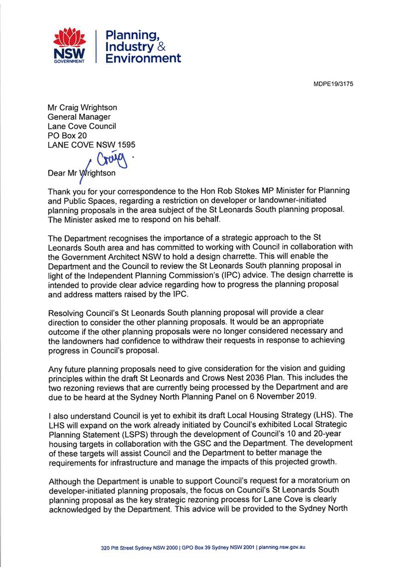
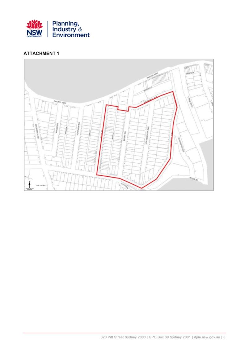
Strategic Review
Council received and published the Terms of
Reference (AT-1) for the Department of Planning, Industry and
Environment’s strategic review of the St Leonards South (SLS) Planning
Proposal. The review involved a Charette (where experts were gathered to review
the scheme) which was conducted on 11 November, 2019.
I note that the community’s
submissions received in response to the public exhibition of Council’s
draft Planning Proposal were provided to the IPC. The community also made
personal representations to the IPC.
All of this was considered by the IPC in
the advice they provided to the Minister for Planning, Industry and
Environment.
The Charette, a strategic review by a panel
of experts, now responds to the IPC advice and was not another consultation
forum.
Once the review is complete, depending on
the scale of change, community consultation would then be undertaken. At the
conclusion of the consultation process Council will be in a position to
consider such amendments in the finalisation of the SLS Planning Proposal.
Moratorium and Evaluation of Planning
Proposals
The review by the Sydney North Planning
Panel of the two developer-led Planning Proposals within the area was
undertaken on Wednesday 6 November 2019. No decision has been published by the
SNPP at this stage. Further information is available on the Planning
Proposals section of Council’s website.
Council also received a response (AT-2)
to its request for a restriction on developer or landowner−initiated
planning proposals in the area. It states: -
“Resolving Council's St Leonards
South planning proposal will provide a clear direction to consider the other
planning proposals. It would be an appropriate outcome if the other planning
proposals were no longer considered necessary and the landowners had confidence
to withdraw their requests in response to achieving progress in Council's
proposal.
Any future planning proposals need to give
consideration for the vision and guiding principles within the draft St
Leonards and Crows Nest 2036 Plan.”
St Leonards Over Rail Plaza
To facilitate the construction of
Council’s proposed St Leonards Plaza open space, a report is being
considered at this Council meeting to make “Recreation Area’ permissible
within the rail corridor. This is necessary as the current zoning for the rail
corridor is Special Purpose (SP-2 Railway), which does not allow its use for
Open Space. If Council adopts the recommendation, a Planning Proposal for
the rezoning will go forward to the Department of Planning for consideration
under the Gateway process.
|
RECOMMENDATION
That the Mayoral Minute be received and noted.
|
Councillor Pam Palmer
Mayor
ATTACHMENTS:
|
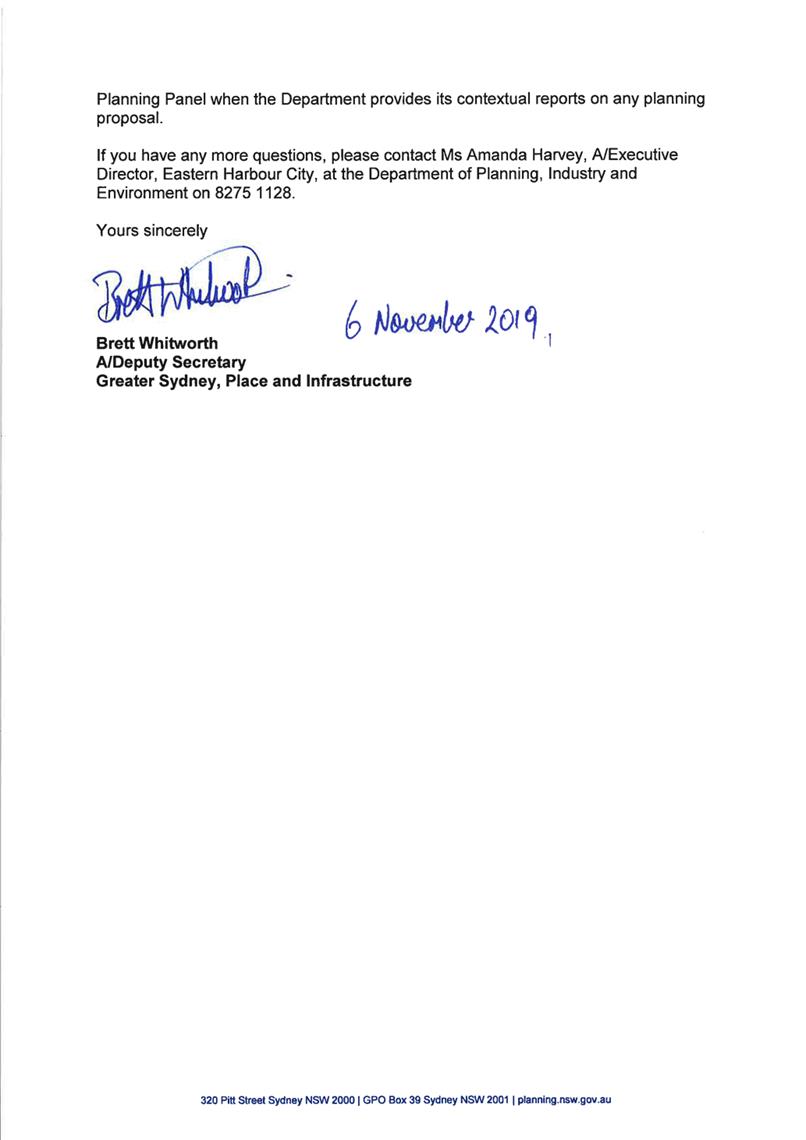
AT‑1View
|
Letter from the Department of Planning
|
2 Pages
|
|
|
AT‑2View
|
Terms of Reference
|
2 Pages
|
|
|
ATTACHMENT 1
|
Letter from the Department of Planning
|
|
ATTACHMENT 2
|
Terms of Reference
|
Ordinary Council Meeting 18 November 2019
TCORP Debt Financing
Subject: TCORP
Debt Financing
Record No: SU785 - 68286/19
Division: Lane
Cove Council
Author(s): Councillor
Scott Bennison; Councillor David Brooks-Horn
TCORP is
offering funding for infrastructure loans at historical low interest rates.
Lane Cove
Council has been fortunate to not have to rely on debt to provide
infrastructure to its residents.
In fact, during
the amalgamation process we were criticised for not having any debt.
Lane Cove
Council’s successful model has relied upon putting the profits from
completed infrastructure projects into new infrastructure projects thereby
avoiding the need for borrowings.
However, given
the low interest rate funding being offered by TCORP it may be advantageous
that Council acquires funding to advance future planned infrastructure
projects.
I believe that
Council should undertake some due diligence and investigate the financial
viability ability of acquiring funding in a low interest rate environment from
TCORP to advance planned infrastructure projects.
|
RECOMMENDATION
That the General Manager undertake initial due diligence
with respect to acquiring funding from TCORP to advance future planned
infrastructure projects and that a report come back to Council with the
following information:-
1) details of funding being offered by TCORP including, interest rates,
fixed/variable, terms and other information considered by the General Manager
necessary for Councillors to make an informed decision; and
2) Details of future infrastructure projects that the General Manager
considers appropriate for consideration of TCORP funding.
|
Councillor Scott Bennison
Councillor
Councillor David Brooks-Horn
Councillor
ATTACHMENTS:
There are no supporting documents for this report.
Ordinary Council Meeting 18 November 2019
Presentation of Annual
Financial Statements - Year Ended 30 June 2019
Subject: Presentation of Annual Financial Statements - Year Ended 30 June
2019
Record No: SU772 - 64439/19
Division: Corporate Services
Division
Author(s): Sarah
Seaman
Executive Summary
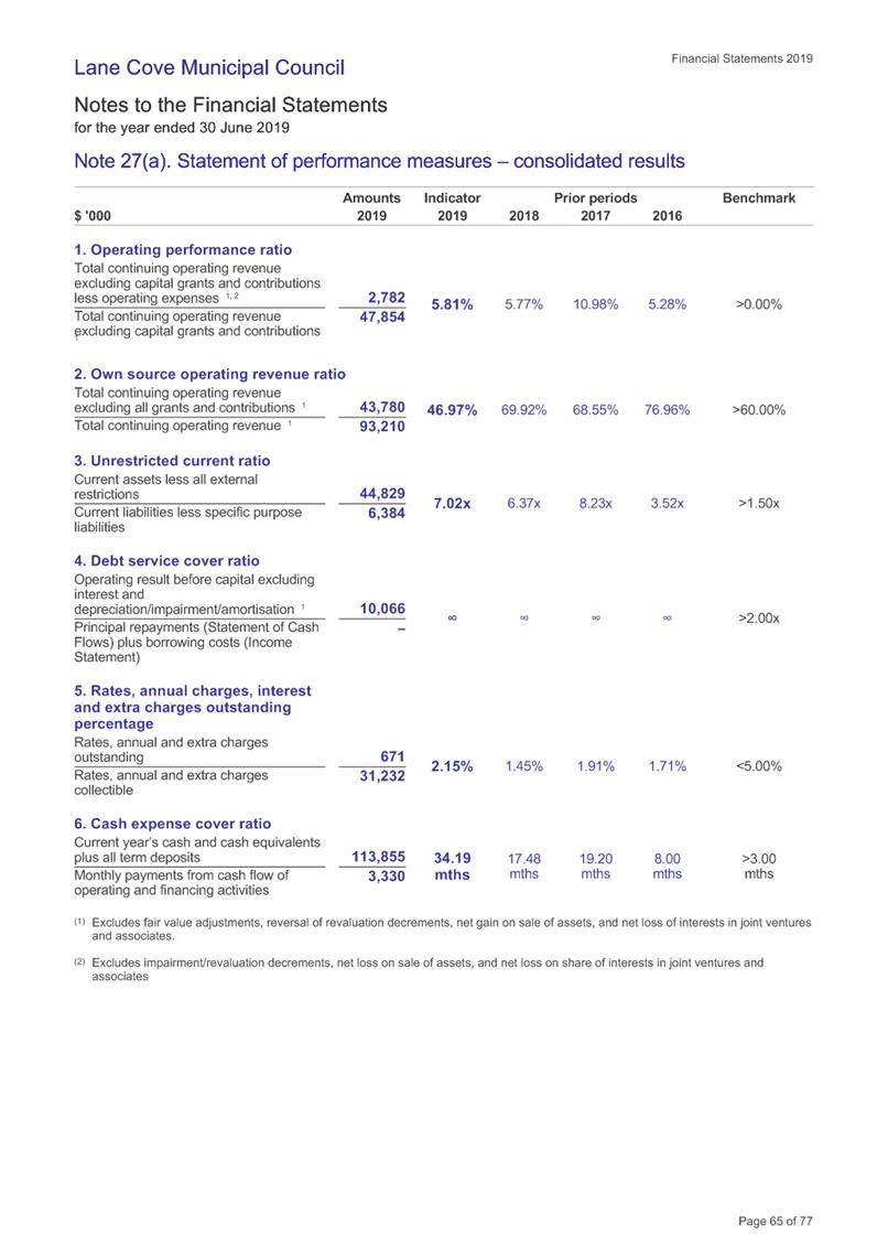
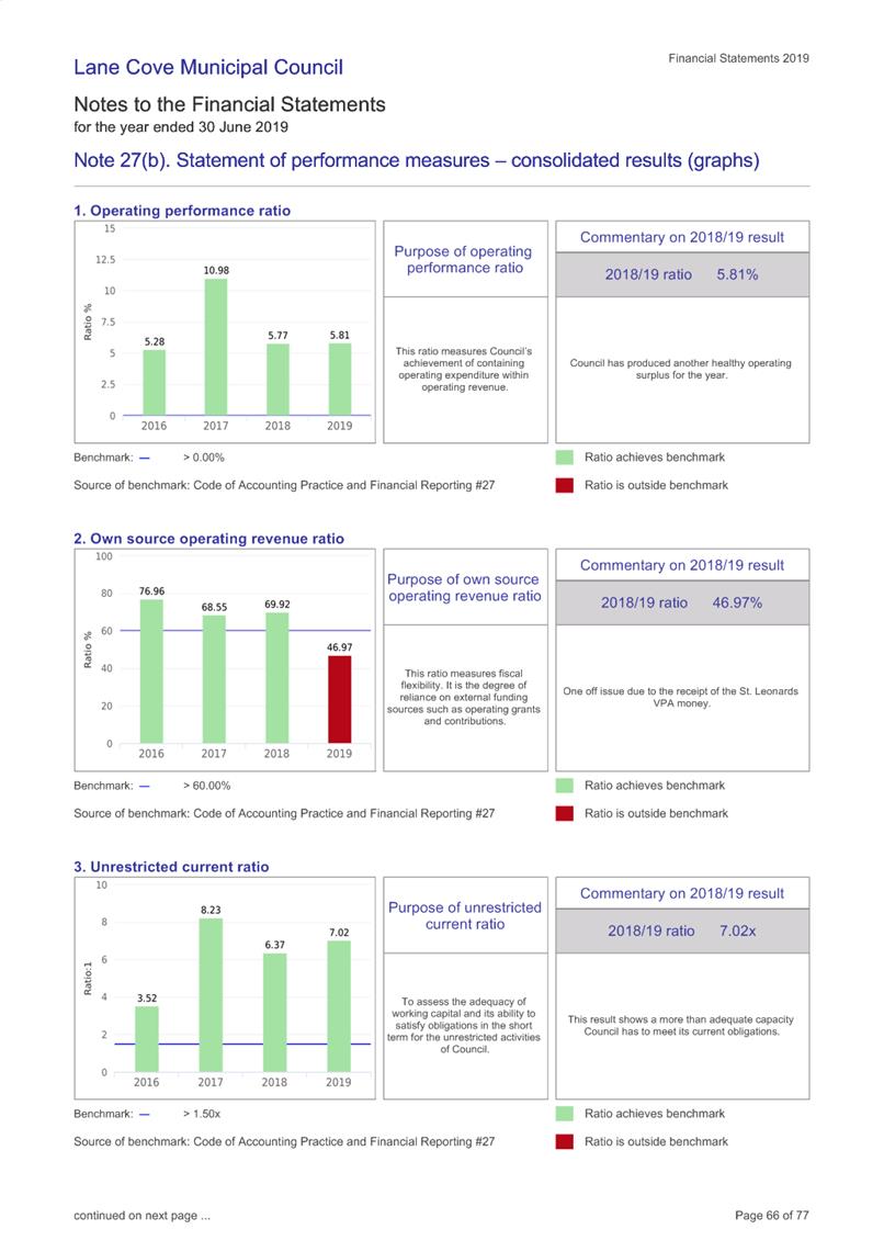
Following completion of the audit,
Council’s Annual Financial Statements for the year ended 30 June 2019 and
the Auditors Report, are presented to Council. It is recommended that the
report be received.
Discussion
Section 418 of the Local Government Act
1993, requires that as soon as practicable after a council receives a copy of
the auditor’s reports:-
a) It must fix a date for the meeting at which it
proposes to present its audited financial reports, together with the
auditor’s reports, to the public; and
b) It must give public notice of the date so fixed.
The audit of the Annual Financial
Statements for the year ended 30 June 2019 has been completed by
Council’s Auditors – Audit Office of NSW, and a copy of their Audit
Report is included with the Financial Statements.
The 2019 draft audited Financial Statements
were presented to the Internal Audit Committee on 11 November 2019, together
with the External Audit Engagement Closing Report.
Notice was given in the North Shore Times
on 31 October 2019 of the intention to present the Annual Financial Statements
at this meeting. The Statements have been available for inspection at the
Civic Centre since 29 October 2019. Written submissions were invited and
at the time of writing this report, no submissions had been received. The
audited financial statements, together with the auditor’s reports, are
now formally presented to Council.
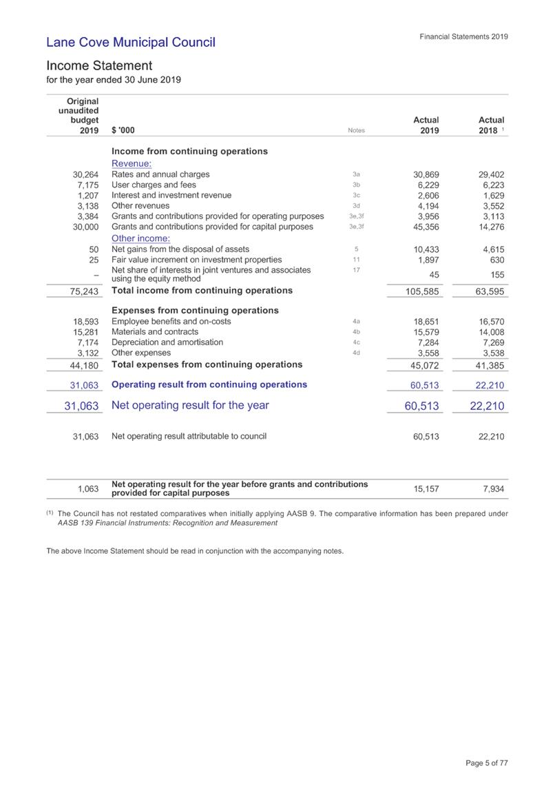
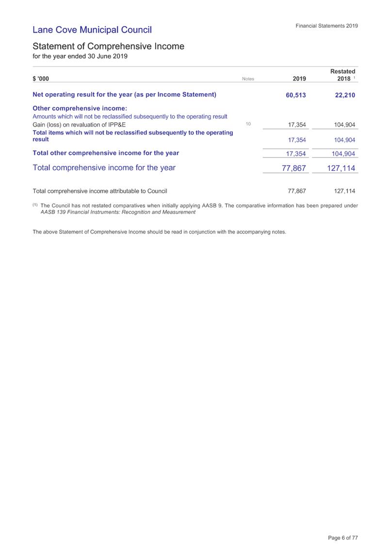
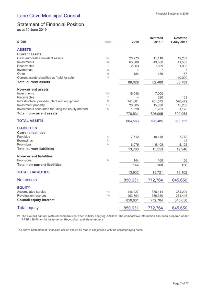
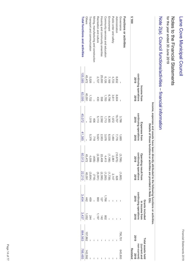
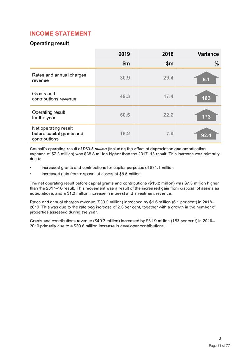
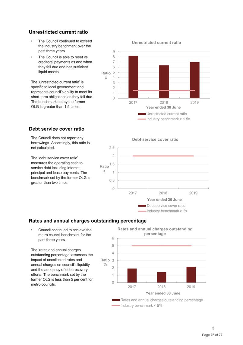
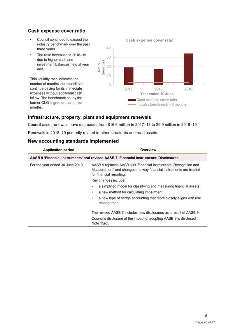
Council’s overall financial result
for the for the year was a surplus of $60.5M. This includes one off
capital revenue for St Leonards VPA.
Council’s Auditor will be in
attendance at the meeting to present the Auditor’s Report. A Copy
of the Annual Financial Statements for the year ended 30 June 2019 are attached
at AT-1.
Conclusion
The results reflect Council’s ongoing
strong financial position established and maintained over several years.
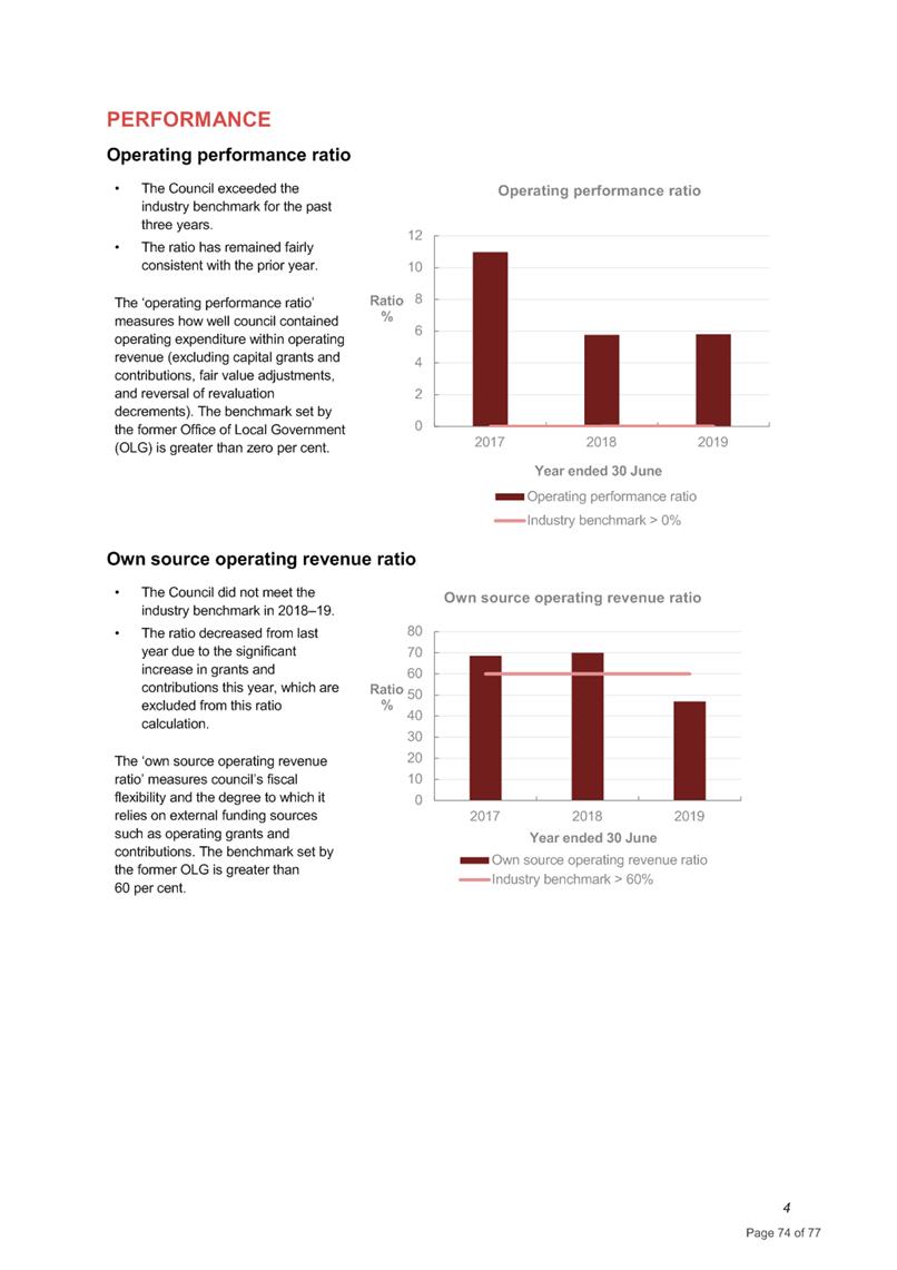
Once again Council significantly exceeded industry benchmarks used in the Fit
for the Future program, except the debt service cover ratio as Council has no
borrowing.
|
RECOMMENDATION
That Council receive and note the Annual Financial Reports
together with the Auditors Report for the year ended 30 June 2019.
|
Jessica Quilty
Acting Executive Manager
Corporate Services Division
ATTACHMENTS:
|
AT‑1View
|
Annual Financial Statements for the Year Ended 30 June
2019
|
98 Pages
|
|
|
ATTACHMENT 1
|
Annual Financial Statements for the Year Ended 30 June 2019
|


Ordinary Council Meeting 18 November 2019
Council submission to
Department of Planning on Greenwich Hospital Redevelopment
Subject: Council submission to Department of Planning on Greenwich Hospital
Redevelopment
Record No: SU7340 - 68000/19
Division: Environmental
Services Division
Author(s): Christopher
Shortt
EXECUTIVE SUMMARRY
The Minister for Planning is the Consent
Authority for the proposed Greenwich Hospital re-development. Following an
initial round of consultation, written submissions on this revised State
Significant Development proposal will be accepted until Thursday 21 November
2019.
The original proposal was modified to
address concerns relating to loss of trees, impact on Pallister House and its
curtilage. Council welcomes these changes, but ultimately Council cannot
support the proposal as it proposes Seniors Living Accommodation which is not
permitted within the SP2 zone.
BACKGROUND
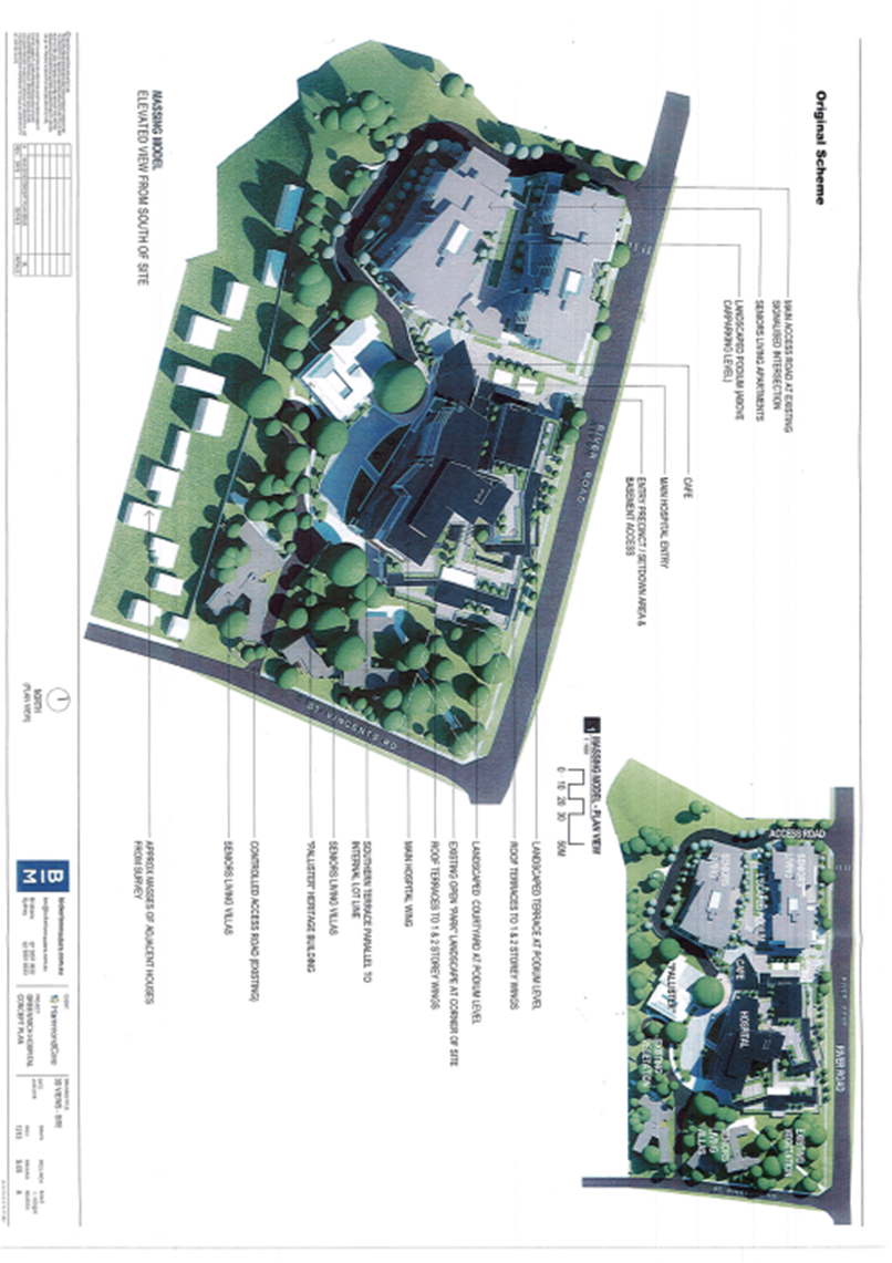
The Original Proposal:
The original
proposed development was for the redevelopment of Greenwich Hospital complex in
stages and included:
· 150 place hospital health care facility with a mix of inpatient
hospital beds, palliative care beds and residential aged care beds;
· Inpatient and outpatient support services and areas necessary to
provide a modern, attractive health facility consistent with
HammondCare’s high standard of care;
· Seniors living units associated with the hospital style campus model
that includes approximately:
ס 6-storey
high seniors living apartment buildings - containing 80 new seniors living
units addressing River Road;
ס 1-2
storey high seniors living units (villas)- 9 villas addressing St Vincents
Road;
ס Pallister
House would be retained, refurbished and continue to fulfil hospital functions
as part of the campus; and
ס Onsite
parking in accordance with code requirements. Including 2 levels of basement
parking.
· The proposed hospital building adopts a podium-tower typology that
is articulated into three faceted wings. The form of the building aims to
address the site’s topography and reduce the appearance of bulk and scale
whilst still achieving optimum organizational layouts for hospital use.
The podium levels provide circulation, servicing, administration and
landscaping; and
· The hospital, health facilities and low-rise dementia care precinct
would have capacity to accommodate inpatient hospital beds, palliative care
beds, residential care beds and outpatient services.
The demolition of the majority of the
existing buildings and structures on site (excluding Pallister House which
would be retained in its current form) is proposed to accommodate the proposed
redevelopment of Greenwich Hospital campus. Demolition would be staged to
allow the hospital and associated facilities to continue functioning.
Council’s previous submission dated 5
April 2019 raised a number of concerns with the concept plan proposed
redevelopment of the Greenwich Hospital. A general overview of the
agreed/requested amendments are listed below:
· Seniors Living Accommodation component is not permitted within the
zone under the Lane Cove Local Environmental Plan 2009. The SP2 Zone only
permits Health Service Facilities. The Seniors Living element should be removed
from the development or at least significantly reduced to be clearly ancillary
to the primary medical use;
· The proposal would result in an unacceptable loss of tree canopy and
is contrary to Planning
priority N19 of the North District Plan; and
· Although the expansion of the hospital
use is supported in principle, the physical bulk of the hospital building is
not supported. The perceived bulk of the maximum 9-storey hospital building is
recommended to be reduced by increasing the distance of
the building from the heritage item and stepping back the south west facade at
each floor level to reduce the massing and visual dominance of the building.
Further
information was also required to be submitted to allow a more comprehensive
understanding of the issues. This included:
· Revised Aboricultural information;
· Details of HammondCare Affordable Housing model;
· Stormwater Management Plan;
· Erosion and Sedimentation control Plan;
· Additional photomontages to demonstrate the visibility of the
proposal from the harbour;
· Construction Noise Management Plan;
· Waste Management Plan;
· Stage 2 Contamination Report;
· Hydrological Survey;
· Confirmation all apartments and villas
are accessible in accordance with AS1428.1; and
· Confirmation the apartment buildings comply with the Apartment
Design Guide.
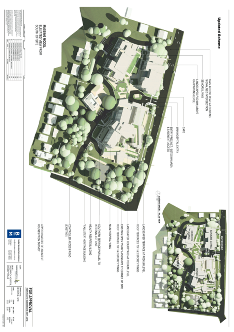
AMENDMENTS
TO ORIGINAL DESIGN:
In response to
the matters raised in the submissions including Lane Cove Council, the
Department of Planning and other state government agencies, community groups
and the public, the following changes to the design are now proposed
General
changes:
· Overall reduction of GFA (from
28,300sqm to 25,500sqm) and FSR (from 0.84:1 to 0.81:1);
· Increase in deep soil planting of 15%
(from 12,000sqm to 13,800sqm);
· Floor space of health services
increased to be greater than the seniors living uses from 14,400sqm (52.7% of total GFA) to 13,000sqm (47.3% of total GFA);
Hospital:
· reduction of building footprint to
allow retainment of additional trees. The western end of the hospital is
reduced in scale, now partially single- storey and concealed beneath a
landscaped terrace to improve sightlines to Palister House from River Road.
· Lower section of hospital now includes
a 2 - 3 storey projecting built form intended to relate more strongly to the
scale of Palister House
· The geometry of the south side of the
hospital has been redesigned to better relate to Palister house and its
heritage curtilage.
· The hospital basement carpark footprint
has been reconfigured to allow greater separation from Palister House. In
particular the section of carparking within the curtilage to be removed to
allow for more planting within the landscape.
Seniors
living:
· Deletion of the nine (9) seniors living
villas proposed in the bushland area adjacent to the St Vincent’s road
frontage;
· Reallocation of the gross floor area
(GFA) from the villas to other areas across the site including a respite care
facility to be located towards the St Vincent’s Road end of the site;
· Changes to proposed building envelopes
including reduction of height of seniors living building;
· Modification to building envelopes to
allow greater sightlines to Pallister House from River Road;
· The northern seniors building envelope
has been reduced at its western end to step down to the neighbouring
residential buildings;
· Amended landscaping design/plan to
improve ‘gardenesque’ landscape setting adjacent to Pallister House
to allow appropriate separation to enhance the curtilage of the heritage listed
building.
Respite Care
facility:
· Three proposed seniors living villas
(1600sqm) have been removed and replaced with a new respite care facility
(700sqm) that is to be located further from the driveway and St Vincent’s
Road.
Landscape:
· A period garden around Palister House
is proposed to contribute to heritage curtilage;
· The former bridle path is to be
interpreted as a pedestrian footpath that would run from River Road to St
Vincent’s Road allowing public access through the heritage landscape of
Pallister House.
ASSESSMENT:
Council has
reviewed the proposed development and provides the following comments for the
consideration of the consent authority.
1. Zoning.
Council’s
maintains its original position that the proposed ‘seniors living’
element is prohibited in the SP2 zone.
It is noted that the total floor area
allocated for seniors living accommodation has been reduced in the amended
design from 14,400sqm (52.7% of total GFA) to 13,000sqm (47.3% of total
GFA). Regardless of this reduction, any residential use for
senior’s accommodation is prohibited in the SP2 zone and is not
supported. Fundamentally Council supports the extension to the hospital and
views the proposed seniors living component as being an impediment to the
intended uses of the site as a hospital.
The applicant
is proposing and justifying the senior’s living component under the SEPP
(housing for Seniors or People with a Disability) 2004.
The subject
site is zoned SP2 Infrastructure in accordance with Lane Cove Local
Environmental Plan 2009.
Permitted with
consent:
The purpose shown on the Land Zoning Map, including any development that is
ordinarily incidental or ancillary to development for that purpose; Roads;
Signage
The purpose
shown on the Land Zoning Map is SP2 Health Services Facilities.
Health Services Facilities are defined as a building or place used to
provide medical or other services relating to the maintenance or improvement of
health, or the restoration to health, of persons or the prevention of disease
in or treatment of injury to persons.
Council
supports the continued use of the site for health and hospital services. The
services outlined by HammondCare including palliative care, rehabilitation,
mental health care for older persons, pain management, among others, fall
within the permitted uses of a health service facility.
The only type
of accommodation that could be considered as Health Service Facilities use is
accommodation for staff (resident doctors, nurses and health care workers)
which is a related use. This accommodation is ordinarily ancillary to the
primary use as Health Service Facilities.
The Seniors
housing (apartments) are a form of residential accommodation and are not
permitted as Health Services Facilities.
Seniors
housing (apartments) are not a permissible use within the zone under
Lane Cove Local Environmental Plan 2009.
The objectives
of the SP2 Health Services Facility zone include:
(1) To provide for infrastructure
and related uses.
(2) To prevent development that
is not compatible with or that may detract from the provision of
infrastructure.
Seniors
housing is contrary to the zoning objectives of SP2 Infrastructure.
The proposed
Seniors living accommodation is not classified as medical infrastructure or a
related use. Seniors living accommodation is not compatible with the intended
use as Greenwich Hospital and would compromise the ability of the site to
extend the provision of medical infrastructure related services in the future.
Although prohibited in the Lane Cove
LEP, Seniors Living may be permitted under the State Environmental Planning
Policy SEPP (Housing for Seniors or People with a Disability) 2004.
Council
acknowledges the need for Seniors living facilities. The projected demographics
of the area are characterized by an aging population. The 2016 census confirmed
that 13.7% of the population within the Lane Cove LGA were aged 65 years and
over. The percentage of residents over 65 is only predicted to rise in the
short to medium term.
Despite these
demographic trends, only appropriate sites should be utilized for Seniors
living accommodation. Seniors living accommodation has been supported at
locations where the use is permissible within the zone.
Below is a
list of existing, approved and potential Seniors accommodation located in
proximity to the site. There are a number of different housing options which
provide Seniors living facilities within the Lane Cove Local Government Area.
· 6 Ulonga Avenue Greenwich. The Baytree
By Ardency Retirement Village;
· 33 Greenwich Road Greenwich. Site
approved for change of use to a residential aged care facility;
· 2 Central Avenue Lane Cove. Pottery
Gardens non-profit retirement units;
· 40A Cope Street Lane Cove. Caroline
Chisholm Retirement Village;
· 15 Figtree Street Lane Cove. Uniting
Church Residential Aged Care;
· 274 – 274A Longueville Road and
4 -18 Northwood Road Lane Cove. A residential aged care facility. The original
proposal was rejected by Council, and the submission of a modified design is
anticipated;
· 92 Burns Bay Road Lane Cove. Northcott
Gardens non-profit retirement units;
· 155 Longueville Road Lane Cove. Uniting
Church Retirement Village; and
· 266 Longueville Road Lane Cove. Seniors
living currently under consideration by the Sydney North Planning Panel.
The
re-development for Seniors housing (apartments) would restrict future expansion
of Health Services Facilities which would be required to meet the needs of the
community. Therefore, permitting these prohibited uses would not be in the
public interest as they would compromise the site’s primary intended use
as a health services facility.
2. Greater
Sydney Commission, North District Plan.
The North
District Plan was developed by the Greater Sydney Commission as part of an
integrated 20-year regional strategy to manage growth, and also enhance
livability, productivity, and sustainability into the future. The
sustainability section of the plan provides a framework to promote the lowering
of carbon emissions and mitigate the impacts of climate change.
Planning
priority N19 of the North District Plan promotes Increasing urban tree
canopy cover and delivering green grid connections. The NSW Government has
set a target through the North District Plan to increase urban tree canopy
cover across Greater Sydney to 40 percent.
The eastern part of the site, along St Vincents Rd contains
a large number of remnant indigenous trees, with Angophora costata
(Sydney Red Gum), Eucalyptus pilularis (Blackbutt) and Eucalyptus
resinifera (Red Mahogany) as canopy species as well as a number of
understorey tree species. There are numerous sandstone rock outcrops in the
vicinity. These trees are species naturally occurring in the area and are
either remnants of the original forest cover or regenerating natural
vegetation. These trees individually and as a group are considered to be
significant trees under Council’s DCP Part J.
The removal of the proposed seniors living villas along the
eastern part of the site would significantly increase the amount of trees to be
retained. The retainment of 211 trees and planting of 60 additional trees would
result in an overall net increase of 5 canopy trees.
In light of
the above, the amended proposal is considered to sufficiently
address the directives of the North District Plan and is supported by Council.
3. Arborist
Report / Biodiversity Report.
The original
design proposed to protect 104 of the 235 trees on the site (44% of all trees
to be retained).
The
resubmitted arborist report considered a larger number of trees. It considered
297 trees, including 254 within the site, 1 boundary tree and 8 trees within
neighboring properties and 34 trees on River Road. The amended design which
removes the villa accommodation would retain/protect 211 trees (71% of all
trees being retained)
The applicants
also propose to plant a minimum of 60 new trees and confirm that a total net
increase of at least 5 trees across the site would be achieved.
As per the original
report, the number of trees proposed to be retained, outlined in the Tree
Protection Plan (section 14.5 and 14.6), are still potentially subject to
development impacts. In particular the TPZ setback required for the trees may
be greater than the structural root zone. As a result additional trees may be
required for removal depending on setbacks when detailed plans are available.
Council welcomes the
revised design to accommodate an increased tree population on the site. The
deletion of the villas in the bushland area adjacent to the St Vincent’s road frontage
will significantly increase the amount if trees to be retained. The revised
design combined with the trees to be planted would result in a total net
increase of trees on site.
4.
Bushland Adjoining Site.
The site is
classified as Land adjacent to Bushland under the State Environmental
Planning Policy 19 Bushland in Urban Areas. The southwest corner of the
site adjoins a public reserve related to Gore Creek.
The proposal
is subject to an assessment against Lane Cove DCP Part H Bushland Protection.
In response to
submissions the applicant has stated that the development would be setback at
least 10m from the bushland at the south-eastern corner of the site.
The DCP
recommends new buildings and structures to be designed and orientated to ensure
reasonable sun access is maintained to adjoining bushland throughout the year.
The
applicant has confirmed that the proposal would not result in significant
additional shadow as the shadow of the proposed building envelope falls largely
within the existing shadow caused by the site’s steep topography and
existing built form. The minimum 10m setback from the southeastern corner is
also considered acceptable.
5. Heritage.
Pallister
House is a two-storey brick, slate roofed Italianate villa constructed in 1892
which is listed on the State Heritage Register as an item of State significance.
In the
original submission Council raised concerns about the bulk of the hospital
building in context to Palister House and its heritage curtilage.
In response
the following changes were made to the design:
· The lower section of hospital now
includes a 2 - 3 storey projecting built form intended to relate more strongly
to the scale of Palister House;
· The geometry of the south side of the
hospital has been redesigned to try to relate better Palister house and its
heritage curtilage;
· The western end of the hospital was
reduced in scale, now partially single storey and concealed beneath a
landscaped terrace to improve sightlines to Palister House from River Road; and
· The hospital basement carpark footprint
has been reconfigured to allow greater separation from Palister House. In
particular the section of carparking within the curtilage been removed to allow
for more planting within the landscape.
The changes to the hospital
building are considered to significantly improve the relationship between the
hospital building and Pallister House. The modifications to facilitate the
necessary upgrades to the hospital will not compromise the heritage fabric of
the Pallister House and associated curtilage.
6.
SEPP (Housing for Seniors or People with a Disability) 2004.
The Seniors housing (apartments) components are prohibited under the Lane Cove LEP 2009, but are proposed as
permitted under the Seniors Living State Environmental Planning Policy (SEPP).
The proposal is considered to be contrary
with Clause 33 of the SEPP. The bulk and scale of the apartment buildings
are considered incompatible with surrounding development.
Clause 33
(c)(iii) of the Policy states:
(iii) adopting building
heights at the street frontage that are compatible in scale with adjacent
development,
Land zoned
within the vicinity of the proposed development is R2 Low Density Residential
with majority 1 and 2 storey dwellings houses. North of the site on River Road
is Greenwich Public School which is approved for 3 storey buildings on site.
The proposed
Seniors housing (apartments) would be 6-storeys and not in keeping with the
scale and the adjacent development.
The bulk and
massing of Seniors Living apartments would be highly visible from the public
way.
Although a
compatibility certificate is not explicitly required to be submitted under
Clause 24 (1) (a) (ii) of the SEPP, it is noted that a number of the key
considerations in Clause 25 as to whether a proposed development is compatible
are relevant in relation to Greenwich Hospital.
It is
recommended that the provisions and assessment criteria of compatibility of the
development with surrounding uses as specified in Clause 25 (5) (b) should be
considered by the consent authority when assessing the concept plan. These
include:
· (ii) ‘the impact that the
proposed development is likely to have on the uses that, in the opinion of the
relevant panel, are likely to be future uses of the land’
As mentioned earlier, concerns are raised by
Council that the proposed independent Seniors living component may inhibit and
compromise the future use of the site for medical uses.
· (v) ‘…the impact that
the bulk, scale, built form and character of the proposed development is likely
to have on existing uses, approved uses and future uses of the land in the
vicinity to the development’
Given that
there are no height controls on site, the proposed development should be viewed
in context to the surrounding built form on and adjoining the site. Concerns
are raised that the proposed scale of the Seniors living buildings and hospital
would dominate Pallister and is not in keeping with the low scale of
residential development surrounding the site.
7.
SREP Sydney Regional Environmental
Plan (Sydney Harbour Catchment 2005)
And Sydney Harbour Foreshores & Waterways Area
DCP.
The site is
located within the Sydney Harbour Catchment area and is therefore subject to
the provisions of the SREP and the DCP.
Clause 3.4
landscape character type 9 of the DCP requires any development within this
landscape… it is sited and designed to maintain the vegetation cover on
the upper slopes and ridgelines.
Council raised
concerns that application proposes the removal of a significant number of
canopy trees alongside new 6-storey Seniors living apartment buildings and the
maximum 9-storey upgraded hospital building. There is no information on the
increased visual prominence potentially along the ridgeline when viewed from
Northwood Peninsula and Onions Point Woolwich among others. The applicant is
recommended to submit a photo montage to demonstrate how visible the proposal
would be when viewed from the southern side of the Lane Cove River.
In response
the applicant provided a landscape character and visual impact assessment
report. The analysis was based on 13 selected view points including along a
number of points along River Road, Bob Campbell Oval, Gore Creek Reserve, Cliff
Road, Ffrench Street. It is noted that the view analysis did no extend
across to the southern side of Lane Cove River as requested.
8. Environmental
Health.
The applicant would need
to provide a detailed Stage 2 Contamination Report.
The applicants
submitted a revision to the Detailed Site Investigation (DSI) that concluded
that the potential risks associate with widespread subsurface contamination at
the site are low, however localised risks associated with total recoverable
hydrocarbons (TRH) in soil and residual contamination associated with the
underground storage tank should be further assessed and remediated
accordingly. The DSI considered that the site can be made suitable for
the proposed development subject to draft recommendations.
The applicant states that that a Stage 2 Contamination Report is not required at
concept stage. Will be submitted at detailed design application.
9. Access.
Council requested confirmation all apartments are
accessible in accordance with AS1428.1
In response the
applicant submitted which confirmed that at Concept SSD stage of design, the
development can provide appropriate accessibility for the project and would
satisfy Clause 26 of the SEPP (Housing for seniors or people with a disability)
2004.
10. Amenity
of Seniors living Apartment buildings.
Although the residential components are not
supported by Council, Seniors apartment buildings may be permitted under the
Seniors Living State Environmental Planning Policy (SEPP). Should approval be
granted by the Consent Authority (Minister for Planning), compliance with the
SEPP 65 and the Apartment Design Guide is required.
Revised ADG
Table: Council requested confirmation that the apartment buildings comply with
the Apartment Design Guide.
The applicant
submitted a revised ADG compliance table was submitted and revealed that:
(i) the apartments comply with minimum solar access and cross
ventilation requirements;
(ii) all habitable and non-habitable rooms comply with minimum floor to
ceiling heights;
(iii) all apartments comply with minimum apartment size (minimum internal
area in sqm);
(iv) the site complies with the minimum required amount of communal open
space, deep soil and visual privacy;
(v) The application proposes a maximum of 9 apartments off a circulation
core on a single level. This exceeds the control which permits a maximum of 8
apartments.
Although not
supported, if approved by the Department of Planning, the amenity of the
seniors living apartments is considered capable of complying with the relevant
requirements.
11. Traffic
Noise.
Council requested an
acoustic report to address noise impacts of traffic.
Applicant
states that a Traffic Noise Report is not required at concept stage and would
be submitted at detailed design application.
12. Details
of HammondCare Affordable Housing model.
While Council does not support the
imposition of residential development on the hospital site outside that
permitted in the SP2 Infrastructure zone, if supported by the Consent Authority,
the design should ensure compliance with affordable housing provisions of the
SEPP Seniors Living. Council requested that that HammondCare submit further
information to allow better understanding of their affordable housing model to
demonstrate compliance with the below clause:
Clause 45
(6)(a)(ii) of the SEPP Seniors Living states:
at least 10% of the dwellings for the accommodation
of residents in the proposed development will be affordable places,
HammondCare
states that Clause 45(6) of SEPP Seniors only requires affordable places if the
proposal seeks bonus FSR through the ‘vertical village’ provisions
of the SEPP. As the application does not rely on Clause 45 of the SEPP, this
clause does not apply. Notwithstanding Hammondcare is a registered charity
which specialises in providing health care services to the elderly and those
that are financially disadvantaged
(i) 45% of aged care patients are low income or disadvantaged
(ii) 50% of inpatients and outpatients are public patients; and
(iii) 15% of seniors living residents benefit from affordable options.
Contrary to
the above justification by HammondCare that compliance with the SEPP is not
required, Council recommends that the development comply with the SEPP and
accommodate a minimum of 10% of all dwellings provide affordable housing.
13. Stormwater
Management Plan.
The applicants submitted a Preliminary Flood Study
which concluded that overland flows from upstream catchments would continue to
be conveyed around the site as per the existing and mitigation measures would
not be required for the development.
Applicant
states that a Stormwater Management Plan is not required at concept stage and
would be submitted at detailed design application.
14. Erosion
and Sedimentation Control Plan.
The
applicant would need to provide an erosion and sedimentation control plan.
Applicant
states that an Erosion and Sedimentation Control Plan is not required at
concept stage and would be submitted at detailed design application.
16. Construction
Noise Management Plan.
The
applicant would need to provide Construction Noise Management Plan (CNMP).
Applicant
states that this documentation is not required at concept stage and would be
submitted at detailed design application.
17. Waste
Management Plan.
The applicant would need to provide a Waste
Management Plan
Applicant
states that a Waste Management Plan is not required at concept stage and would
be submitted at detailed design application.
18. Hydrological
Survey.
The
applicant would need to provide a Hydrological Survey.
Applicant states that this documentation
is not required at concept stage and would be submitted at detailed design
application.
CONCLUSION
The applicant has
considered comments and concerns raised by Council and others modified and
aspects of the proposal to address Council’s concerns.
Council acknowledges and
supports the removal of the Seniors Living villas as it would result in a
significant increase in the total trees being retained on the site. In
comparison to the original proposal, the revised design is considered to be in
accordance with Councils environmental sustainability objectives and the policy
and the directives of the North District Plan.
Council
appreciates and acknowledges proposed changes to the hospital building which
better relate to the Pallister House building and its curtilage. The
reduction in bulk to the western side of the hospital and more considered
approach to the geometry on the south side would result in a superior and
sympathetic outcome. It also improves sight lines to Pallister House from the
primary Street frontage on River Road to allow the heritage item to be more
visible from the public way.
Despite the
positive amendments to the overall design, Council does not support the
proposed residential use in the SP2 zone which is prohibited.
Under Council’s
Local Environmental Plan, the land is zoned for Health Service Facilities.
The proposed development provides for seniors housing which but for the
provision of the SEPP, is not permissible and does not meet the objectives of
the zone. In this regard the proposed Seniors Living units and Villas are not
supported by Council.
The proposal is
recommended to be modified to consist of Health Service Facilities only.
Council
acknowledges the need for Seniors living facilities. But considers the subject
site inappropriate for this use.
The proposed multi-storey
residential buildings development would not be consistent with the R2 Low
Density Residential one and two stories development within the vicinity which
would not be consistent with the provisions of State Environmental Planning Policy (Housing for
Seniors or People with a Disability) 2004.
As stated in
the original submission, however Council is supportive in principle, of a
proposal for the re-development of the existing Hospital and expansion to allow
additional health care facilities.
|
RECOMMENDATION
That Council
prepare a submission to the Consent Authority (Department of Planning)
advising of the above issues and concerns in particular:-
a) Council does not
support the Seniors living units and villas component of the proposal and as
such should be deleted from the consent proposal; and
b) Council advise
the Department of Planning, that should it determine in favour of the
application, the conditions included in AT-2 should be imposed.
|
Michael Mason
Executive Manager
Environmental Services Division
ATTACHMENTS:
|
AT‑1View
|
3D Site View - Updated and Original Scheme
|
2 Pages
|
|
|
AT‑2View
|
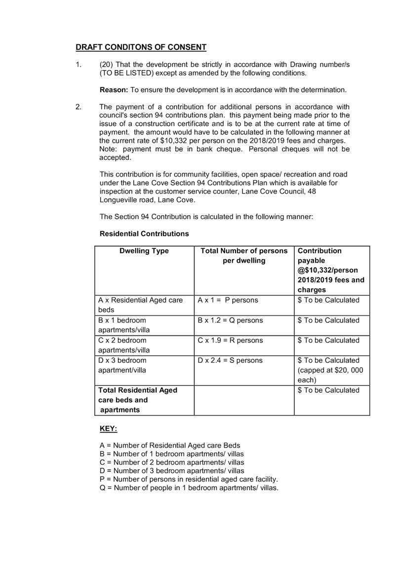
Draft Conditions of Consent
|
20 Pages
|
|
|
ATTACHMENT 1
|
3D Site View - Updated and Original Scheme
|
|
ATTACHMENT 2
|
Draft Conditions of Consent
|
Ordinary Council Meeting 18 November 2019
Village Traffic Changes
- Coxs Lane / Finlayson / Birdwood
Subject: Village Traffic Changes - Coxs Lane / Finlayson /
Birdwood
Record No: SU1326 - 65934/19
Division: Open Space and
Urban Services Division
Author(s): Sashika
Perera
Executive Summary
This report provides an update on the
traffic changes in Coxs Lane, Finlayson Street and Birdwood Avenue adopted by
Council in 2017. All changes are of track for implementation, however, it is
recommended Council not proceed with the construction of indented parking bays
in Coxs Lane at this time, and a review be undertaken of the effectiveness of
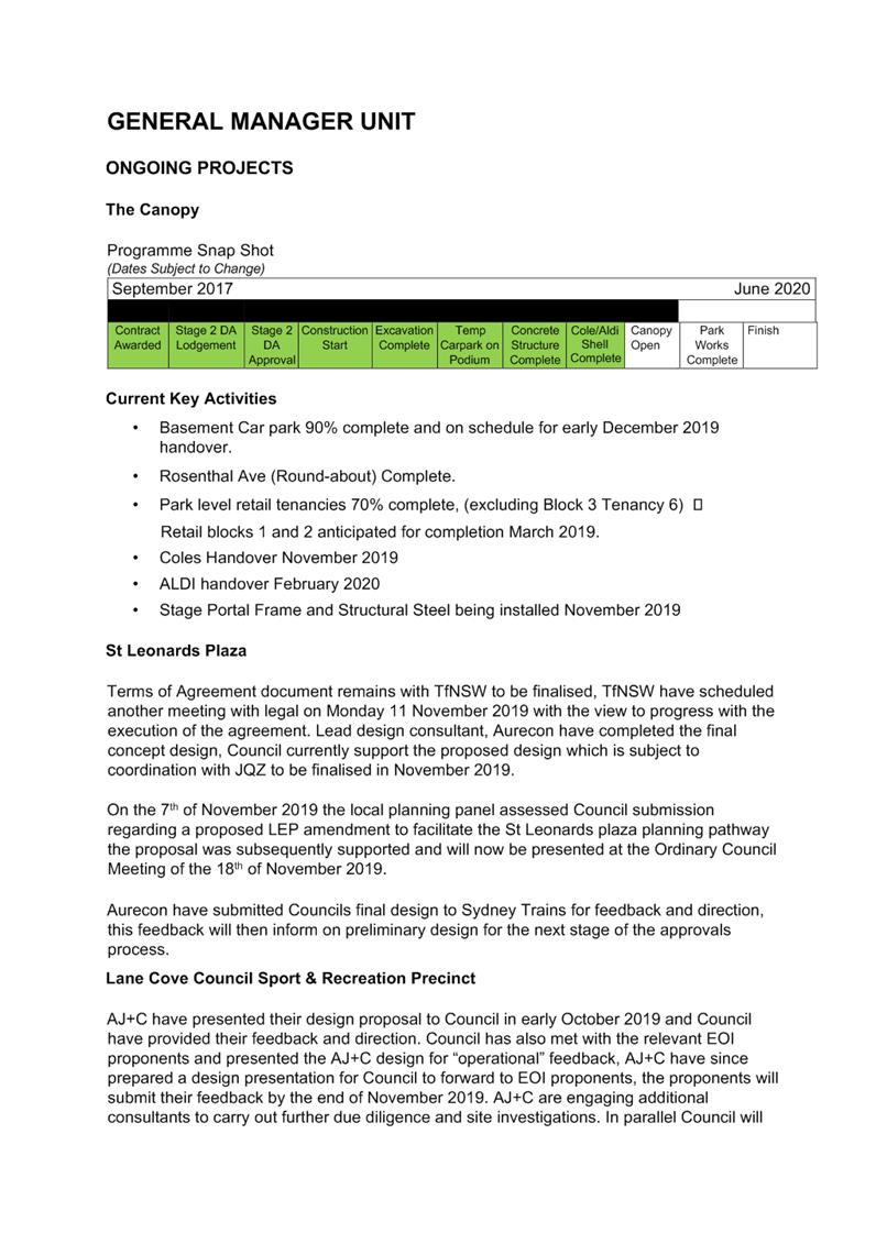
all the changes post the opening of The Canopy development in June 2020.
Background
Due to The Canopy development, new
developments within and in close proximity to the Village and the general
background traffic growth, it was identified in 2017 that traffic needs to be
managed differently in the Village, in particular to deter through traffic from
passing through the village.
In May 2017, Council resolved that several
traffic and parking changes be implemented to coincide with the opening of The
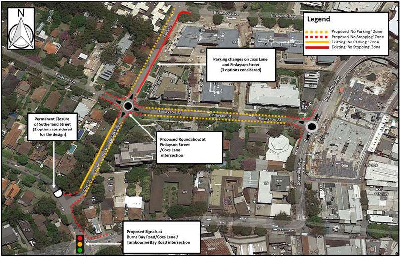
Canopy car park, which is due to open in early December 2019. The following
diagram shows the proposed changes
Discussion
The following provides the current status
of each of the adopted changes: -
|
|
Proposal
|
Recommendation/status
|
|
1
|
The signalisation of Burns Bay Road/ Tambourine Bay Road/
Coxs Lane proceed and Council undertake the detailed design including for
submission to the RMS for approval;
|
SIDRA modelling completed, RMS
supportive, detail design submitted to RMS network operations for approval.
Tender for work undertaken but not
awarded pending RMS final approval.
|
|
2
|
The full closure of Sutherland Street at Coxs Lane
intersection proceed and Council undertake the detailed design for submission
to the RMS for approval;
|
Consultation to occur on the proposed
cul-de-sac configuration to allow finalisation of the closure. Traffic
Management Plan for the closure completed and submitted to RMS for approval.
|
|
3
|
Three (3) months after the implementation of Parts 1 and 2
above, Council undertake a survey of traffic flow in Graham Street to
determine if parking should be restricted to one side of Graham Street;
|
Approved by Traffic Committee, monitoring
to occur first quarter 2020.
|
|
4
|
Indented parking bays be constructed on
the eastern side of Coxs Lane with 2P;7am-7pm and ‘No
Parking’ restrictions to be implemented on the western side of Coxs
Lane between Finlayson and Birdwood Avenue, to coincide with the opening of
the new Rosenthal car park;
|
Approved by Traffic Committee, under
review, see discussion in the report.
|
|
5
|
Subject to an appropriate design being
developed, a roundabout be constructed on the corner of Finlayson Street and
Coxs Lane, to coincide with the opening of the new Rosenthal car park;
|
Approved by Traffic Committee. Works to
be undertaken in January/February 2020 once temporary construction detours
are no longer required.
|
|
6
|
‘No Parking’ restrictions be
implemented on both sides of Coxs Lane between Finlayson Street and
Sutherland Street, to coincide with the opening of the new Rosenthal car
park;
|
Approved by Traffic Committee, affected
properties notified, changes to be implemented in December 2019.
|
|
7
|
Council to undertake traffic counts on
Coxs Lane between Finlayson Street and Sutherland Street following the
implementation of proposals 1 and 2 to determine if traffic calming devices
are required;
|
Approved by Traffic Committee, monitoring
to occur throughout 2020.
|
|
8
|
‘No Parking’ restrictions be
implemented both sides of Finlayson Street between Rosenthal Avenue and Coxs
Lane, to coincide with the opening of the new Rosenthal car park;
|
Approved by Traffic Committee, affected
properties notified, changes to be implemented in December 2019.
|
|
9
|
Council work with the RMS to signalise
the intersection of Epping Road/ Coxs Lane to facilitate a right hand turn
onto Epping Road.
|
Ongoing
|
Item 4, relates to parking in Cox’s
Lane and the recommendation proposed in 2017 was for the road pavement to be
widened or full-time parking restrictions implemented on both sides between
Finlayson Street and Birdwood Avenue to maintain two-way traffic flow.
Council
consulted the wider community at the time as follows:-
1. Letterbox drop – approximately
1,050 letters delivered to the area;
2. E-newsletter – 6,400 recipients;
3. Survey via Council website;
4. Community information evening at the
Council chamber – 15 March 2017;
5. A number of on-site meetings with the
local residents;
6. Advertisement to North Shore Times;
and
7. Information published at the Civic
Centre and the libraries.
In relation to
Item 4 the following two options were proposed:-
• Option
A – Retain existing road width and remove on-street parking (6.5m kerb to
kerb)
• Option
B – Widen the street by three metres on the eastern side (8.3m kerb to
kerb and 1.2m footpath). Indented parking bays are
proposed on the eastern side
Council received
263 responses, the majority (55%) supported Option B. Council ultimately
determined that indented parking bays be constructed, and parking be restricted
to one side of Coxs Lane between Finlayson and Birdwood Avenue, and the land
located at the north-eastern corner of Coxs Lane/ Finlayson Street (17-21
Finlayson Street) be acquired to facilitate the indented parking bays;
As part of the development consent for 2-22
Birdwood Avenue, a three metre setback along the Coxs Lane frontage was
dedicated to Council. A concept design was developed where seven indented
parking bays are proposed along the Coxs Lane frontage of 2-22 Birdwood Avenue.
Whilst there is a setback of three metres
along the Coxs Lane frontage of 17-21 Finlayson Street, the land has not been
dedicated to Council. The Body Corporate of 17-21 Finlayson Street were
approached by Council to acquire the land to accommodate another five indented
parking bays along the Coxs Lane frontage.
The property owners were not in favour of
selling the land to Council as they value the green space it provides. Council
understands that view is shared by the body corporate of 2-22 Birdwood Avenue.
While Council could proceed to compulsorily acquire the land from 17-21
Finlayson Street, this process is both time consuming and expensive.
Given the views of the property owners,
Council has three options:-
· Option 1 –‘No Stopping’ be implemented on both
sides of Coxs Lane between Finlayson Street and Birdwood Avenue; with no
replacement parking
· Option 2 – Construct seven indented parking bays on the
eastern side of Coxs Lane along the frontage of 2-22 Birdwood Avenue only;
· Option 3 – Construct 12 indented parking bays on the eastern
side of Coxs Lane between Finlayson Street and Birdwood Avenue where Council
must compulsory acquire the land along the Coxs Lane frontage of 17-21 Birdwood
Avenue.
Given the number of changes being
implemented simultaneously, it is recommended Council initially proceed with
Option 1, and Council review any further changes required once The Canopy
development opens in June 2020 by no later than November 2020.
|
RECOMMENDATION
That:-
1. Council
receive and note the report;
2. No
Stopping’ be implemented on both sides of Coxs Lane between Finlayson
Street and Birdwood Avenue; with no replacement parking; and
3. Council
review the impacts and need for any further changes once The Canopy
development opens in June 2020 by no later than November 2020.
|
Martin Terescenko
Executive Manager - Open Space and Urban Services
Open Space and Urban Services Division
ATTACHMENTS:
There are no supporting documents for this report.
Ordinary Council Meeting 18 November 2019
Further Report -
Sale & Acquisition of Land - 15 Standish Street, Greenwich
Subject: Further Report - Sale & Acquisition of Land - 15 Standish
Street, Greenwich
Record No: SU3021 - 68391/19
Division: General Managers
Unit
Author(s): David
Stevens; Craig Wrightson
Executive Summary
This is a further report on the proposal to vary the
Deed of Agreement for Road Closure and Voluntary Sale and Acquisition of Land
adjoining Lot 2 DP 1128693, 15 Standish St, Greenwich.
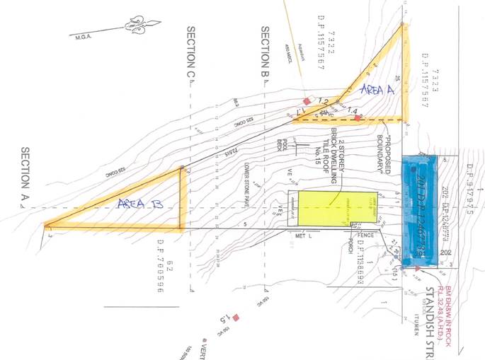
Council entered into a Deed of Agreement in February
2014 to formally close part of Standish Street, Greenwich and sell part of the
land (284 m2 known as Lot 201 – in exchange for ‘Area A’, for annexation to Gore Creek Reserve (Reserve).
As a result of changes to statutory instruments and
requirements of the Rural Fire Service that were not envisaged in the original
Deed, this report will recommend a variation to the Deed which amends the
location of the portion of land for annexation to the Reserve (Area B) and the
agreed compensation to be paid by the adjoining Lot Owner for the amount of
$18,000.
Background
Council at its meeting of 21 October 2019
considered a report in relation to the Deed of Agreement for Road
Closure and Voluntary Sale and Acquisition of Land adjoining Lot 2 DP 1128693,
15 Standish Street, Greenwich. Council resolved that the matter be deferred to a Councillor Workshop. The site is shown
in the following Figure
Discussion
The proposal was presented to the
Councillor Workshop held on 11 November, 2019. The following key issues were
clarified: -
· The land swap (Area B) is the same area as the previously proposed
Lot A, plus or minus 10 metres.
· Area B, the land now proposed to be transferred is immediately
adjacent to Council owned bushland and is therefore preferred to Area A which
is isolated.
· Area A
is to be maintained by the Lot Owner as an APZ to the existing dwelling and
road reserve as it provided for fire protection.
· The property is not located in a designated 10/50 vegetation
clearing entitlement area therefore, any removal of vegetation in Area A would
require Council approval.
· The current land size is 2135 sqm, with the min lot size or
subdivision 550sqm, the additional land will not provide additional development
rights.
Conclusion
In summary, this proposal involves the formal closure of an
unused portion of Standish Street, Greenwich and subsequent transfer of the
that portion to the adjoining Lot Owner. In turn, the Lot Owner will
transfer Area B to Council with the Lot Owner to pay Council $18,000.00 for the
transaction.
|
RECOMMENDATION
That Council:-
1. Agree to the
variation in the Deed in respect of the Road Closure and Voluntary Sale and
Acquisition of land in Standish Street, Greenwich;
2. Grant the
necessary easement(s)for the existing aerial service wires to meet the
requirements of Ausgrid;
3. Agree to
compensation payable by the landowner to Council in the amount of $18,000;
4. Enter into a
Contract for the sale of Lot 201 and agree to the transfer of Area
“B” to Council; and
5. Authority be
granted to the Mayor and General Manager to affix the Common Seal to the sale
contract and any necessary associated documentation to complete the Deed for
the transaction.
|
Craig Wrightson
General Manager
General Managers Unit
ATTACHMENTS:
There are no supporting documents for this report.
Ordinary Council Meeting 18 November 2019
Energy and Water Use
Project Update
Subject: Energy and Water Use Project Update
Record No: SU7238 - 66314/19
Division: Environmental
Services Division
Author(s): Fiona
McCleary
Executive Summary
At the Ordinary Meeting of 16 September
2019, Council requested that a report be prepared for the November 2019 meeting
that outlines the carbon and water use baseline research findings, and provide
recommendations on the future management of both energy and water consumption
in Council owned buildings, and throughout the LGA.
Council has been working with
Sustainability Consultants, Kinesis, since August 2019 to gather data and
assess the challenges and opportunities in setting and meeting emissions and water
use targets. The baseline year has been set at 2016/17 and the target year as
2036. This report outlines the data trends as a basis to investigate
opportunities in these areas ahead of providing a detailed report in March 2020
which will outline strategies and actions to achieve emissions targets which
will be:-
• Based
on robust and transparent data;
• Responsive
to what Council can affect; and
• Linked
to a measurable tracking and monitoring framework.
Background
At its September 2019 meeting Council
resolved that:-
“A report come back to Council in
November 2019 on the review currently being conducted by a Sustainability
Consultancy to establish a carbon and water use baseline per capita/dwelling
and aspirational targets for both community and corporate (Council) emissions
and water use”.
The research findings to date have shaped
early emissions and water reduction recommendations, ahead of a more detailed
report due early 2020, which will outline targets for consideration and
specific strategies to reach them.
Discussion
This project leverages analysis already undertaken, and Council
internal knowledge. Council has been tracking greenhouse gas emissions, waste
data and water consumption across its operations, with detailed reports and
benchmarking against Council’s 10 highest consuming facilities, dating
back to 2005. Additional data has been sourced from the Greater Sydney
Commission, utility providers, the Australian PV Institute, ABS Census 2016 and
TfNSW, amongst others. Access to this data means that Kinesis are incorporating
the latest dwelling, population, job and floor space projections to understand
the expected growth in emissions from new developments. Council has also
established a working group, made up of key internal stakeholders, who are
working alongside consultants to help guide development of strategies and
actions.
Council emissions and water use
One of the key findings from the data
analysis is that Council’s operations contribute less than 2% of the
total emissions of the Lane Cove LGA. In the baseline year of 2016/17 Council
generated 5,229 Tonnes of Co2, while the remainder of the LGA generated 279,000
tonnes.
Council first introduced the Sustainability
Levy to address climate change in 2006. Over the time Council has implemented a
range of best practice sustainability measures across our assets which has
resulted in a reduction in emissions by 28% since 2015, despite an increasing
population and increase in the number and scale of Council’s facilities
(refer to Table 1).
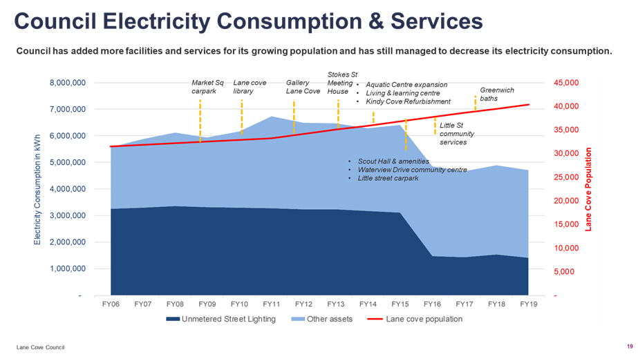
Table 1. Councils electricity consumption, population
growth and facilities expansion 2006-2019
Across Council owned assets, the Aquatic
Centre is the highest energy user, creating 34% of all energy emissions and
using 49% of water.
Council has seized the opportunity
presented with the outdoor pool replacement to implement energy savings through
the use of sustainable design and development. New sustainability measures for
both the grandstand and marshaling area include a significant solar
installation. The latest technology pool filters are expected to result in
substantial energy savings due to reduced heat loss and lower re-heat costs.
Also, it is anticipated that the new pool will generate water savings with a
new and efficient plumbing system.
Street lighting is Council’s
second highest energy user, creating 26% of all Council emissions. In August 2019 the Lighting the Way project began in Lane Cove
with 1162 street lights being replaced with energy efficient LED lights, which
will significantly reduce Council’s emissions. The program continues to
roll out across the LGA with more than 57% of lights already completed. This
has resulted in a 17,551kWh reduction in emissions between August and September
2019, which is equivalent to powering the Creative Arts Studio for six months.
The sustainability measures for the pool
and the street lighting project will be factored into emissions and water use
targets.
The Sustainability Consultants are
researching additional measures to maximise emission reductions which will be
the subject of a report to Council in March 2020.
Residential and non-residential energy
and water use
With the residential and non-residential
sectors making up 98% of emissions across the LGA, engaging these sectors would
be critical if lower emissions and water use is to be achieved.
In the baseline year of 2016/17, this
sector generated 279,000 tonnes of Co2 emissions.
The residential sector generated 55% of
emissions. Within the residential sector, 59% of emissions came from
electricity, followed by 27% from transport, 9% from gas and 5% from waste.
The non-residential sector generated 45% of
emissions. Within this sector, 79% of emissions came from electricity, 18% from
transport and 3% from gas (commercial waste data is not available).
Early recommendations being evaluated for
residential and non-residential include:
· Prioritising engagement with large asset owners that have
significant roof space to benefit from renewable energy. Schools in
particular provide a significant opportunity as they own multiple assets, have
large roof space and dependable, daytime energy loads;
· Seek to raise policy issues at a State level with the Department of
Planning and Environment to set locally specific performance standards for new
residential and non-residential developments (for example increasing BASIX
pre-commitments through Council’s Local Environment Plan and Development
Control Plan);
· Develop a strategy to conserve water and encourage water sensitive
urban design;
· Identify and develop opportunities to increase access to electric
vehicle infrastructure.
The research is evaluating emissions and
water use by suburb and per capita to ensure recommendations are relevant and
tailored to each area.
Conclusion
Following the declaration of a climate
emergency, Council is investigating pathways to achieve emissions and water
reductions both across the community, and within Council’s operations.
Council operations contribute only 2% of the total emissions of the
Lane Cove LGA. Yet, Council can seek to take a leadership position by
implementing sustainability measures within its operations and engaging with
the broader community.
Whilst Council is well placed to have a direct and positive
influence on the community, the State and Federal government also play a
crucial role in responding to the Climate Emergency. By raising awareness,
supporting projects and collaborating with all stakeholders in our community,
Council can foster change and grow commitment to a sustainable climate.
|
RECOMMENDATION
That the report be received and noted.
|
Michael Mason
Executive Manager
Environmental Services Division
ATTACHMENTS:
There are no supporting documents for this report.
Ordinary Council Meeting 18 November 2019
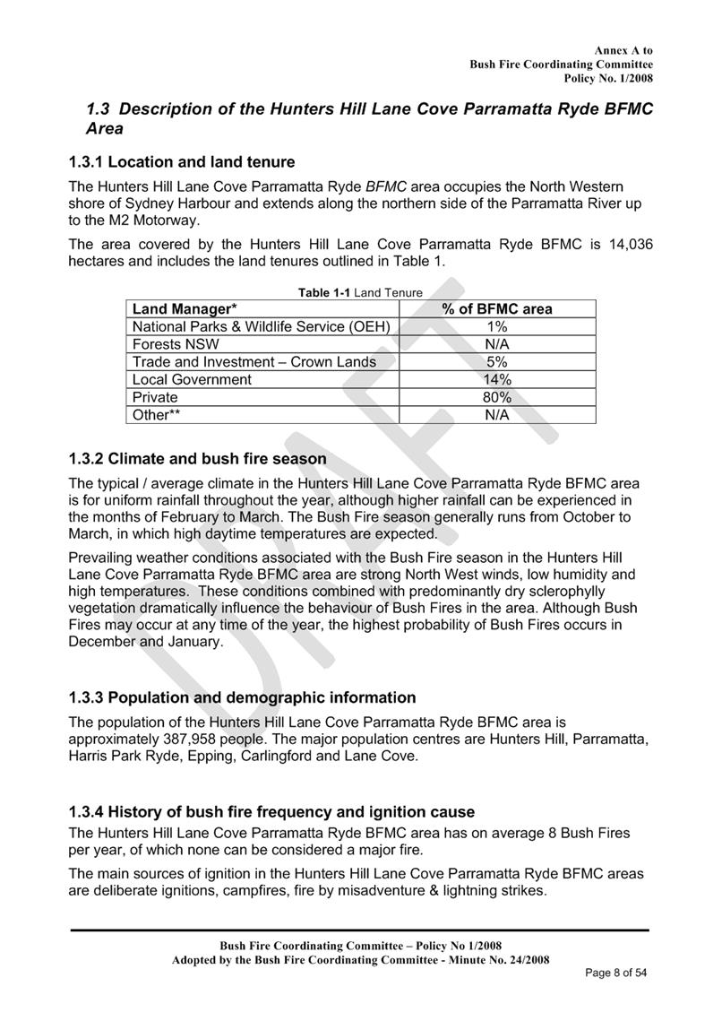
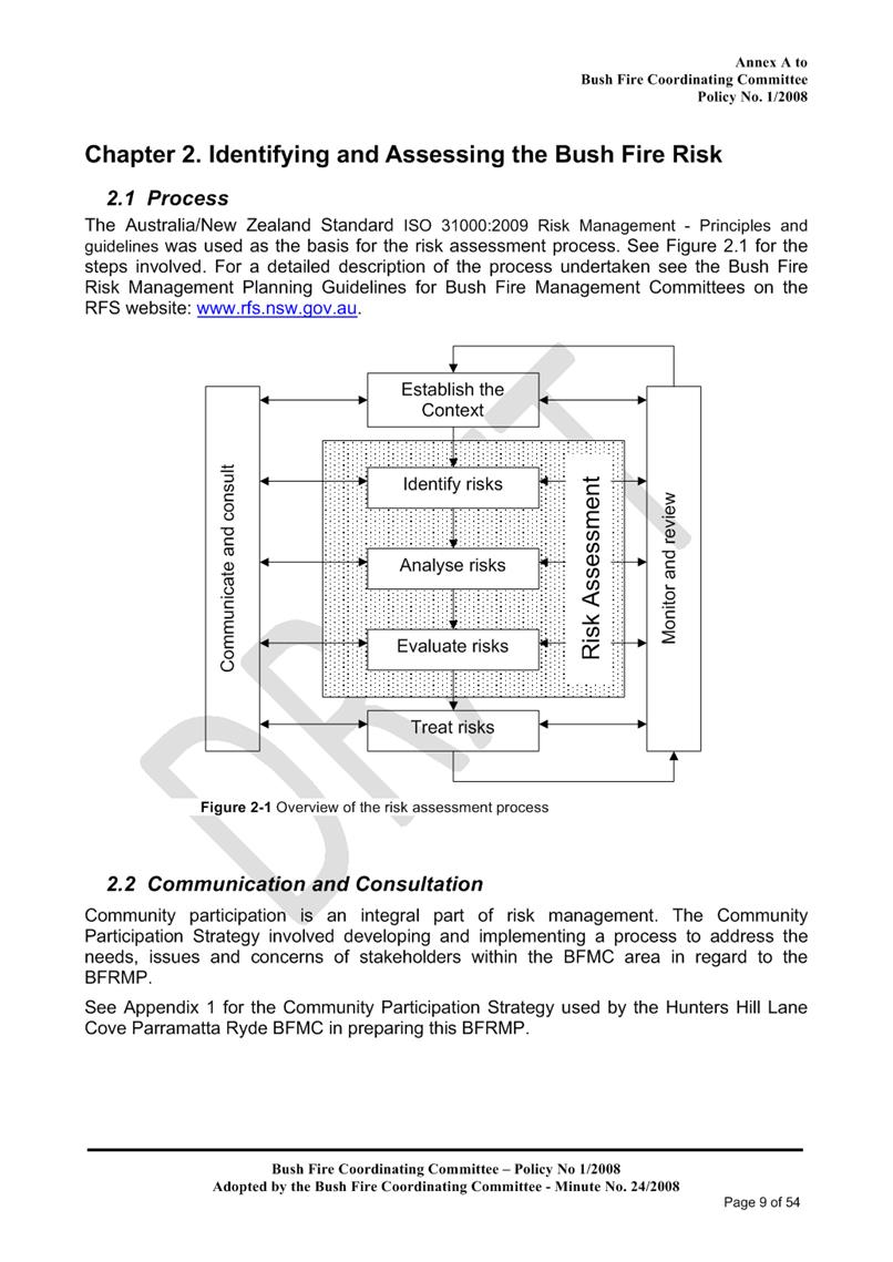
Hunters Hill, Lane Cove,
Parramatta, Ryde, Bushfire Risk Management Committee - Bushfire Risk
Management Plan - 5 year plan
Subject: Hunters Hill, Lane Cove, Parramatta, Ryde, Bushfire Risk Management
Committee - Bushfire Risk Management Plan - 5 year plan
Record No: SU5576 - 66537/19
Division: Open Space and
Urban Services Division
Author(s): Jeff
Culleton
Executive Summary
The purpose of this
report is to advise on the implementation of the 2019/20 Bushfire Risk
Management Plan (BFRMP). Before a
BFRMP can be endorsed by the NSW Bushfire Coordinating Committee, the plan must
be available for public review for no less than 42 days. This report recommends that the draft BFRMP be
on public display.
Background
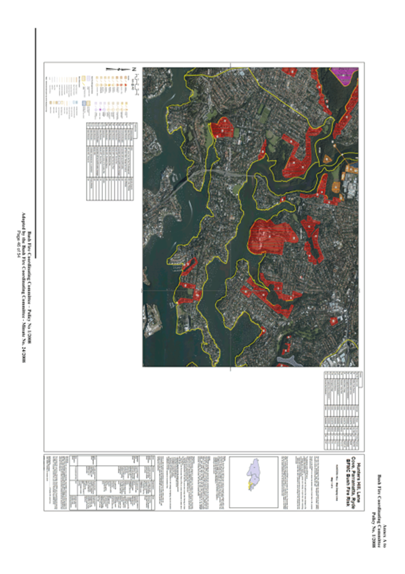
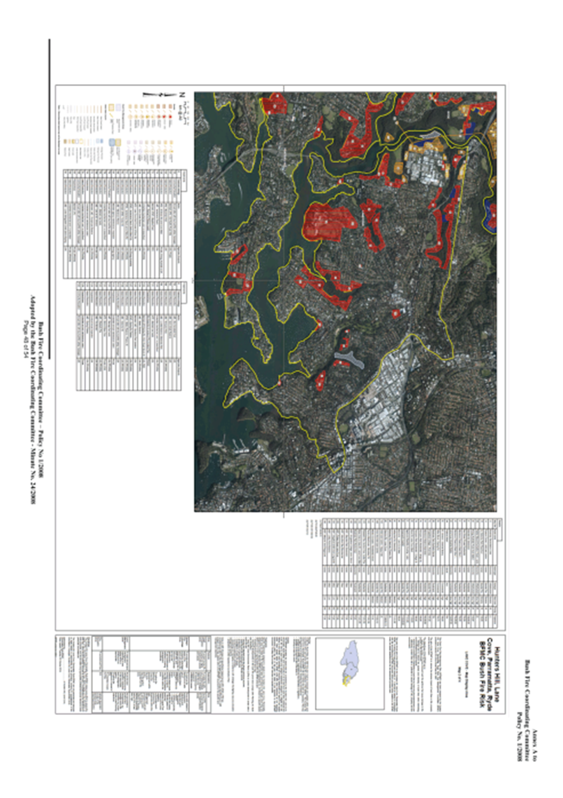
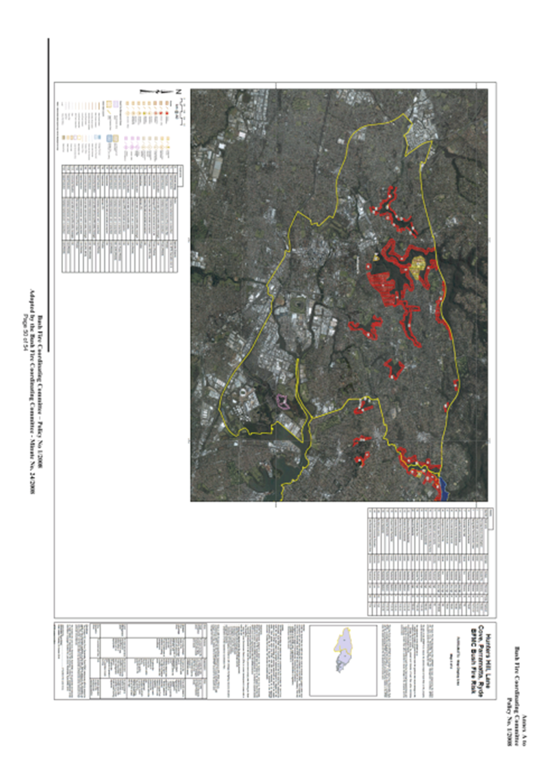
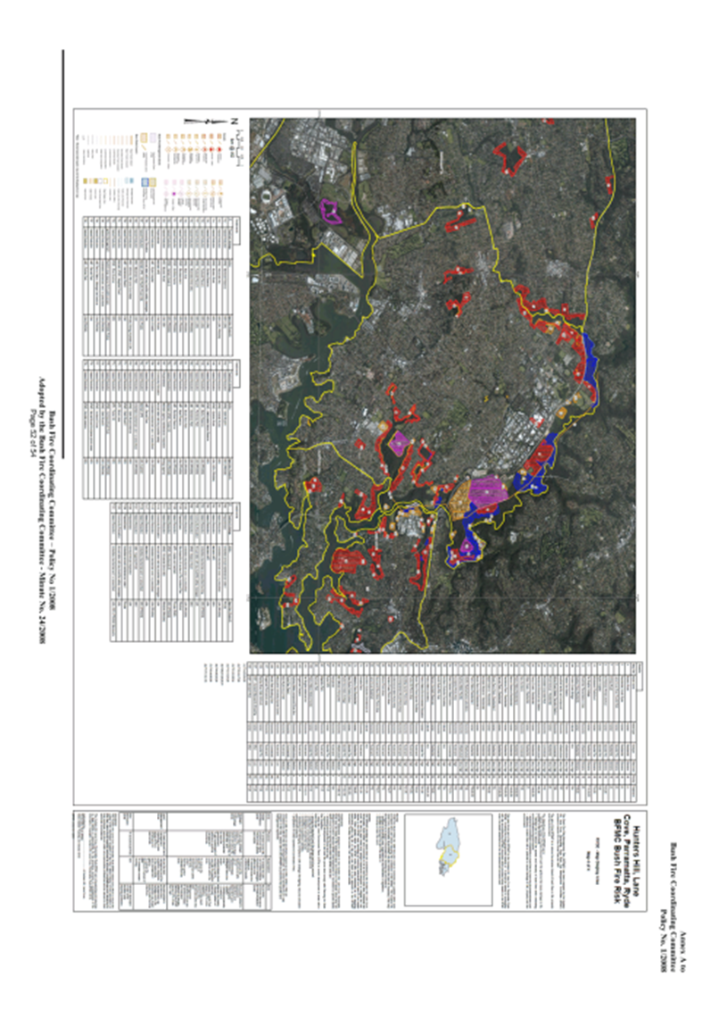
The Bushfire Risk Management Plan
for Hunters Hill, Lane Cove, Parramatta and Ryde Councils was prepared by the
Bushfire Management Committee in conjunction with the NSW Rural Fire Service.
The aim of the plan was to identify the assets at risk and prioritise hazard
reduction works over the following 5 years. Hazard reduction works include
hazard reduction burns as well as manual hazard reduction works undertaken as
part of the Bush Regeneration Program.
This Bushfire Risk
Management Plan (BFRMP) has been prepared by the Hunters Hill, Lane Cove,
Parramatta, Ryde Bushfire Management Committee (BFMC) pursuant to section 52 of
the Rural Fires Act 1997.
The aim of this BFRMP
is to reduce the adverse impact of bushfires on life property and the
environment.
The Objectives of this
BFRMP are to:
- Reduce the number of human induced bushfire
ignitions that cause damage to life, property or the environment
- Manage fuel to reduce the spread and intensity
of bushfires while minimizing environmental/ ecological impacts
- Reduce the community’s vulnerability to
bush fires by improving its preparedness; and effectively contain fires with a
potential to cause damage to life property and environment.
Discussion
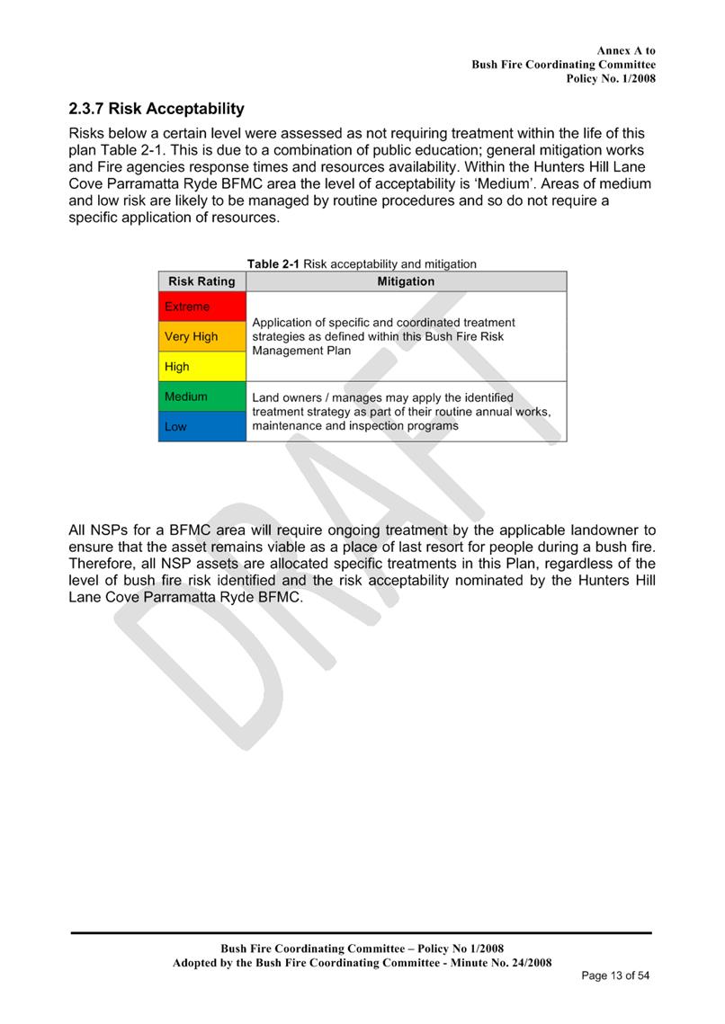
The Bushfire Risk
Management Plan (BFRMP) was prepared by the Bushfire Management Committee
(BFMC) in conjunction with the NSW RFS, Fire and Rescue. The draft plan is to
be placed on public exhibition for 42 days from 19th November to 30th
December 2019.
Under the Rural Fires
Act 1997 this plan must be reviewed and updated within each successive
five-year period following the constitution of the BFMC. The Hunters Hill, Lane
Cove, Parramatta, Ryde BFMC will also review this plan as necessary. This may
be triggered by a range of circumstances, including but not limited to:
- Changes to the BFMC
area, organizational responsibilities or legislation
- Changes to the
bushfire risk in the area or
- Following a major fire
event.
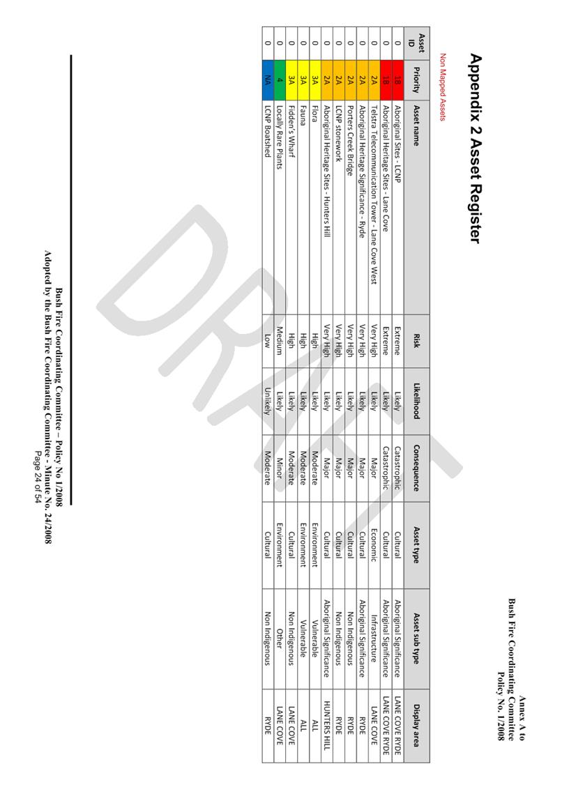
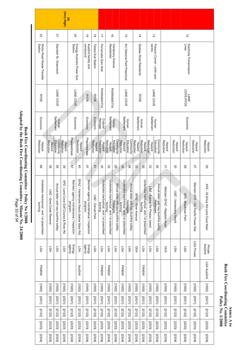
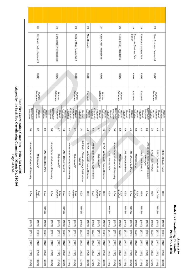
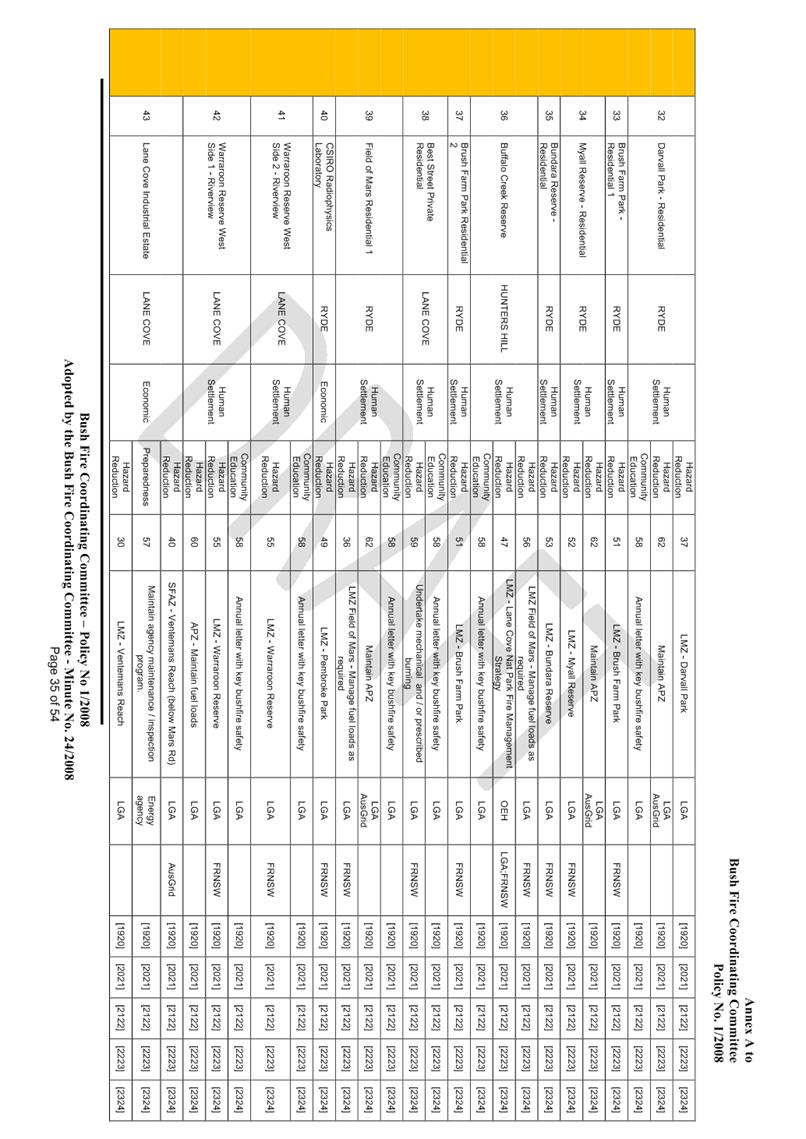
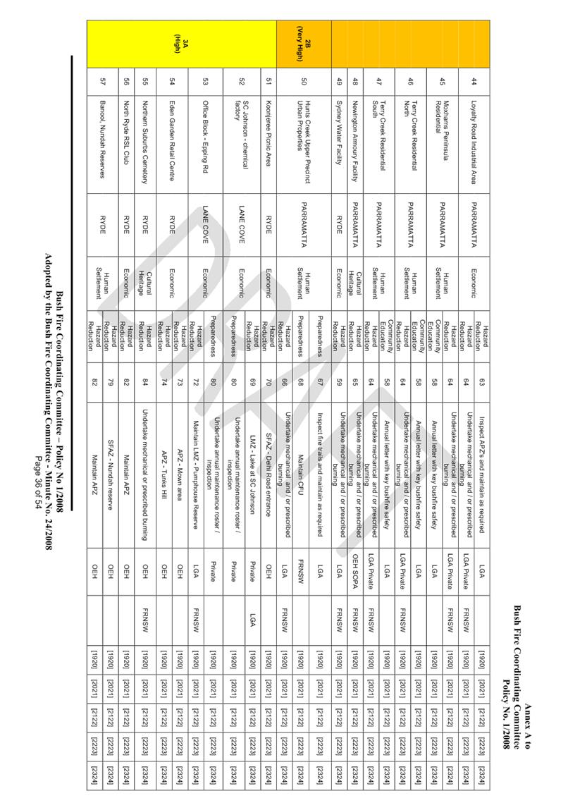
This BFRMP identifies
the assets that are considered by the Hunters Hill, Lane Cove, Parramatta, Ryde
BFMC and community to be at risk from bushfires, assesses the bushfire risk to
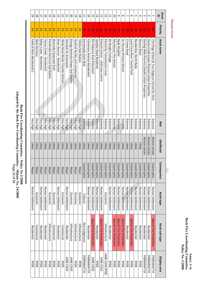
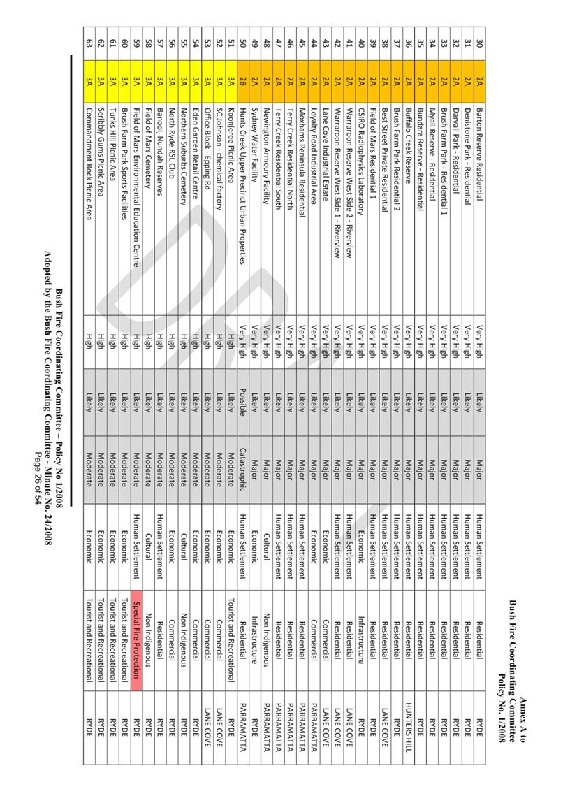
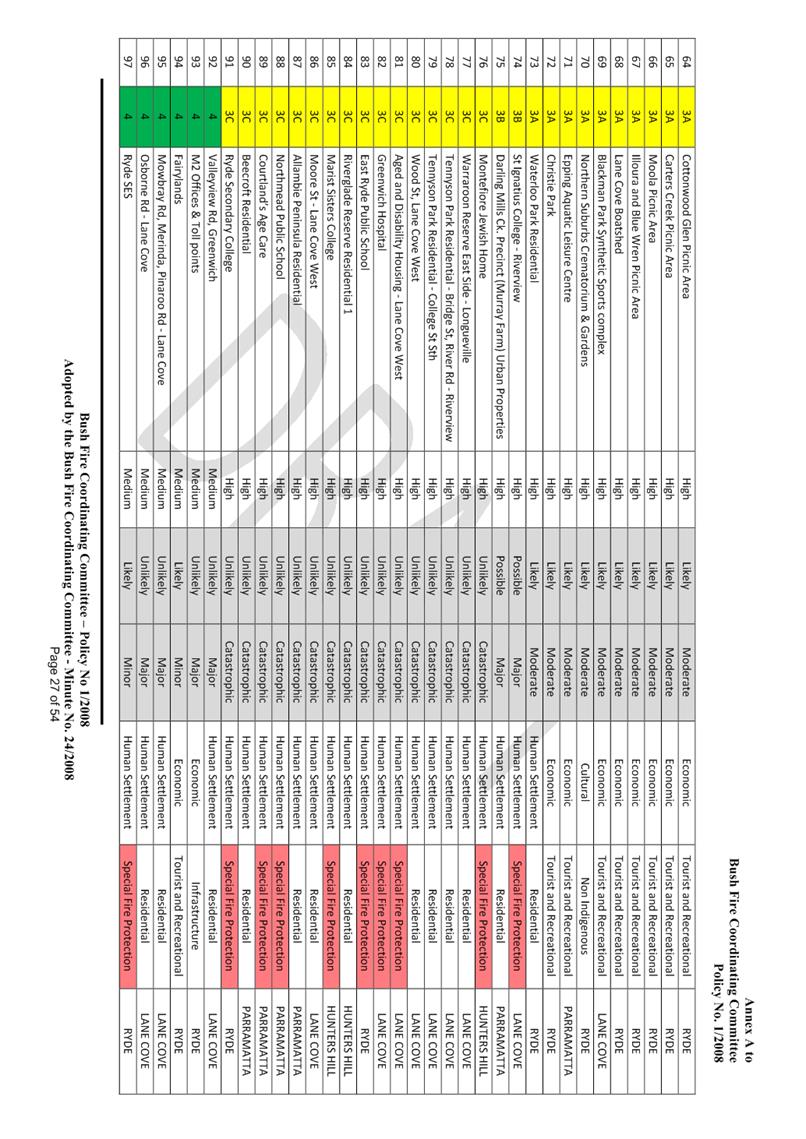
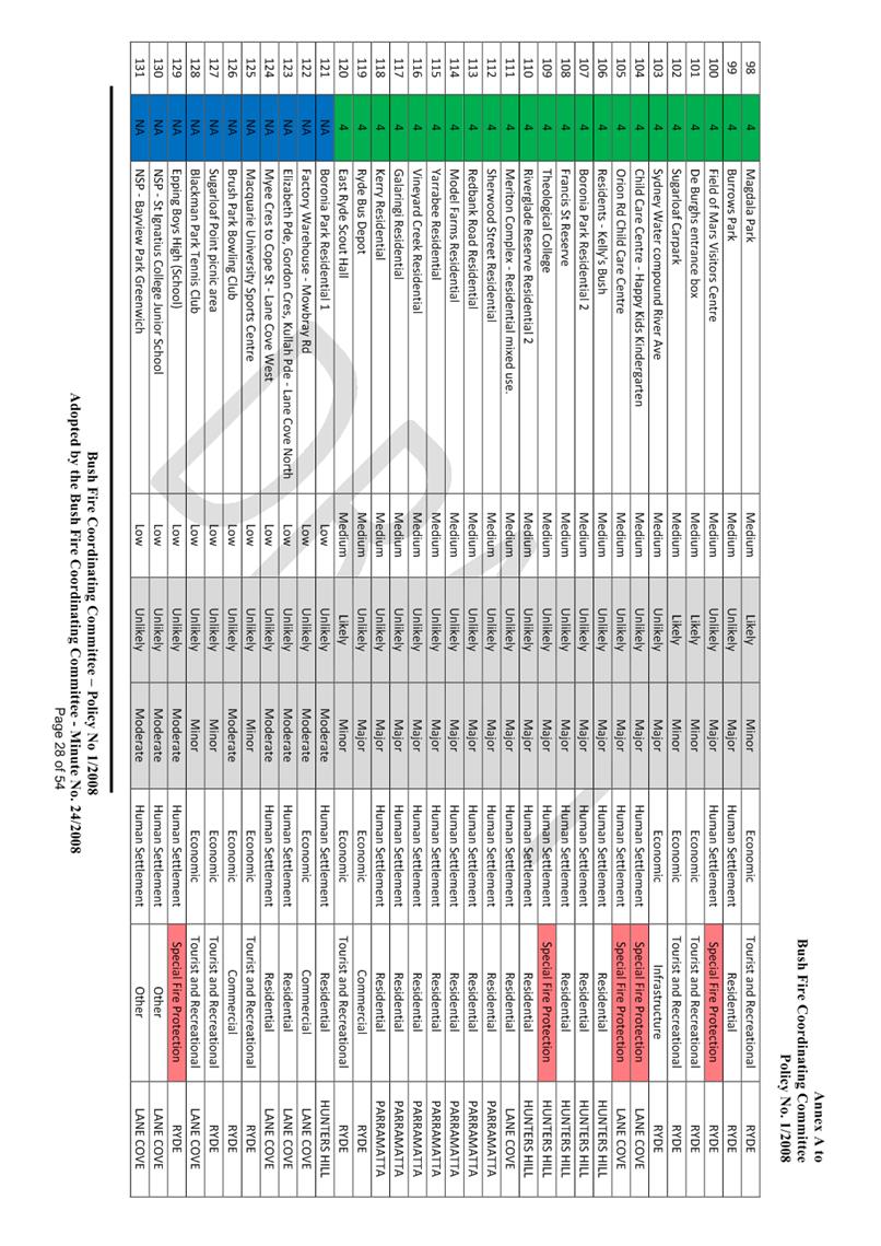
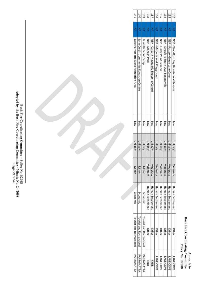
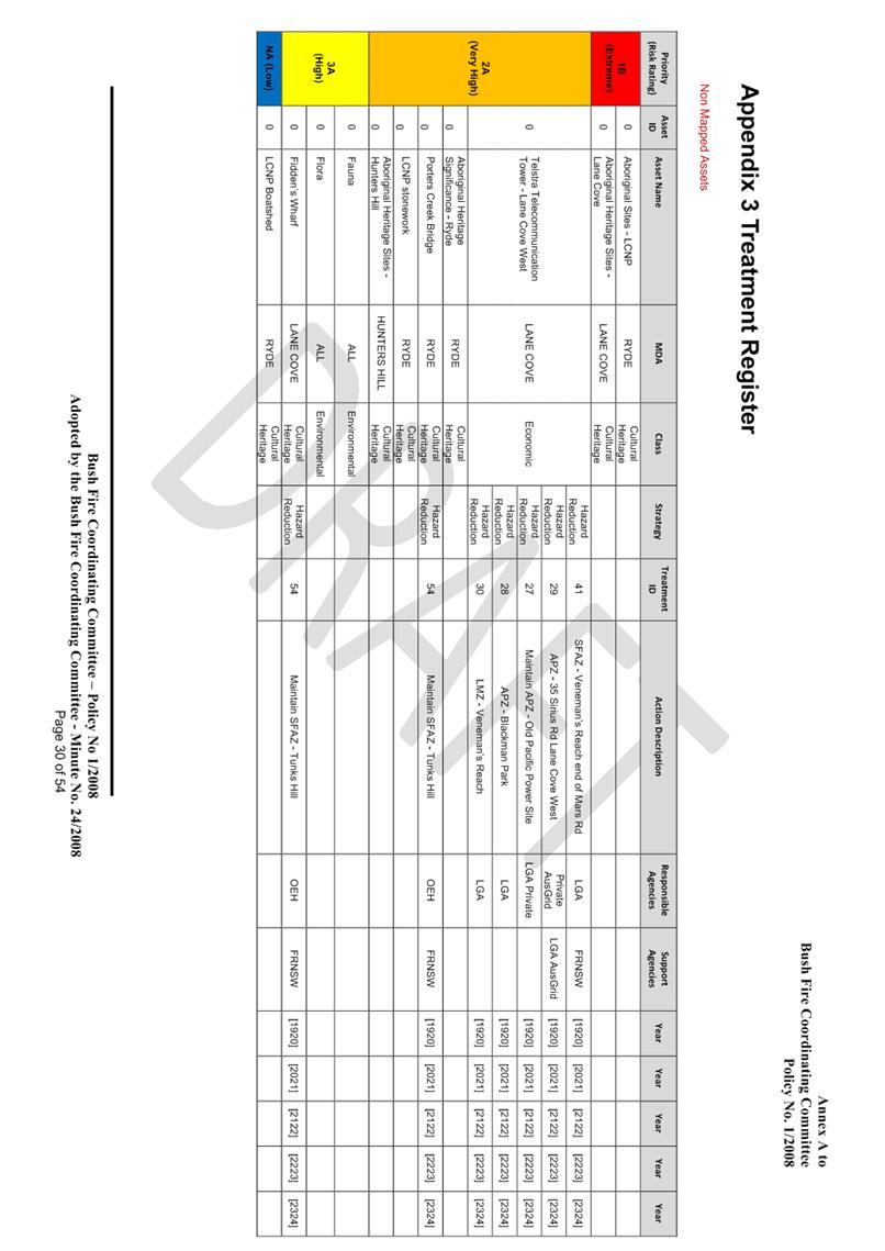
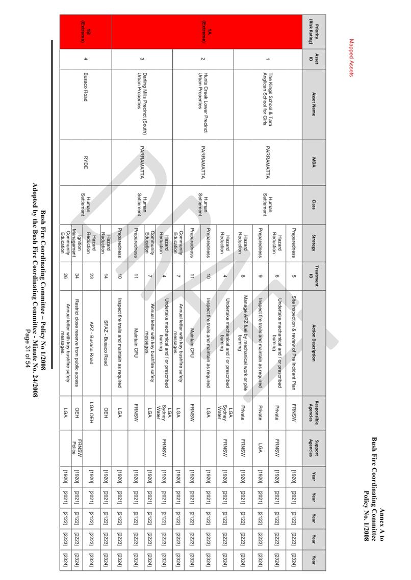
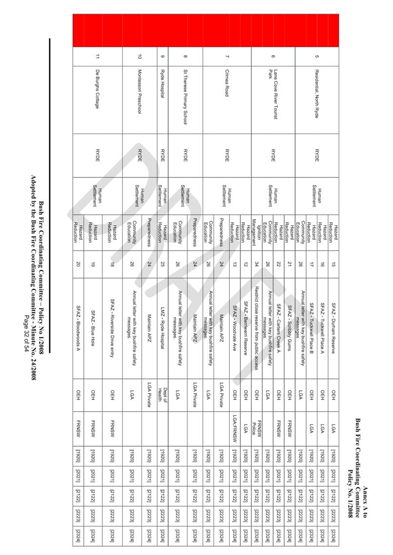
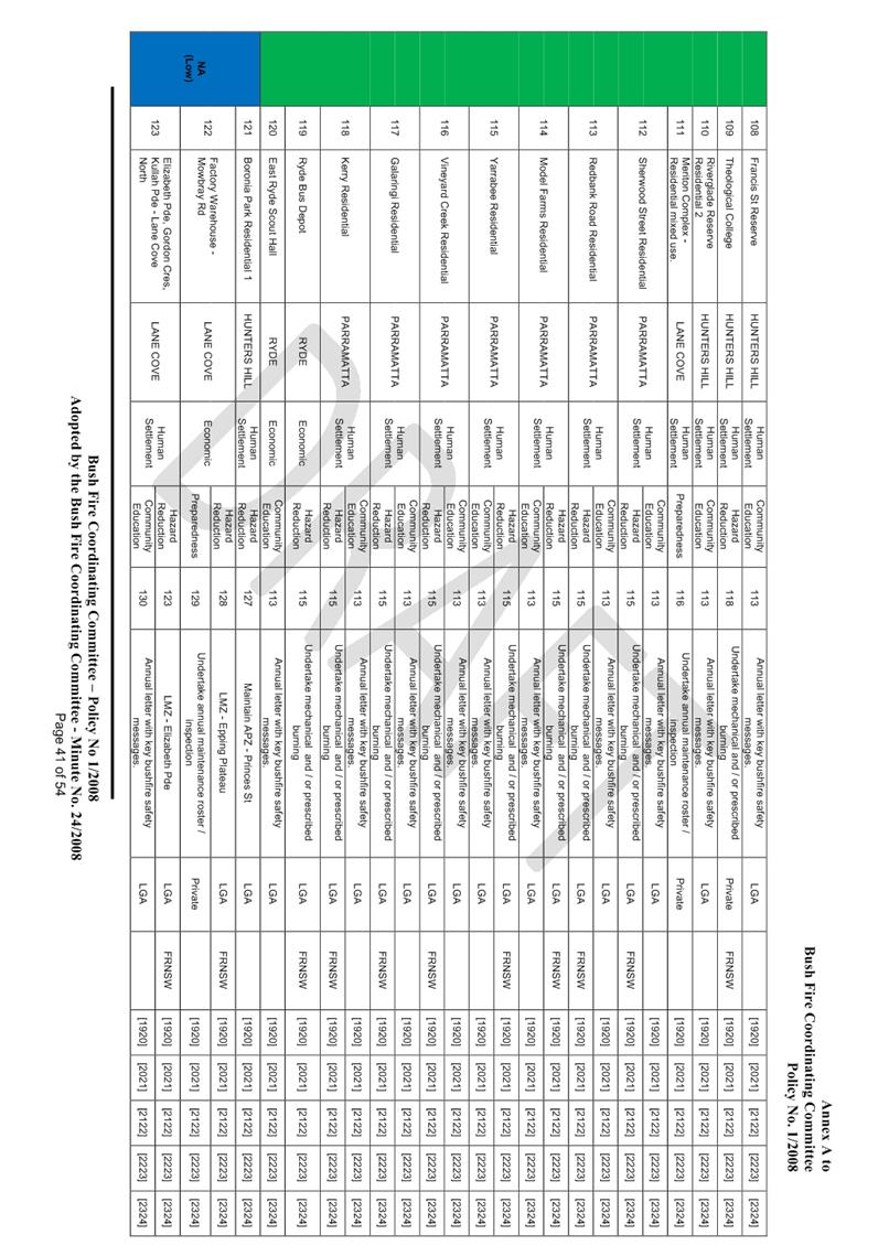
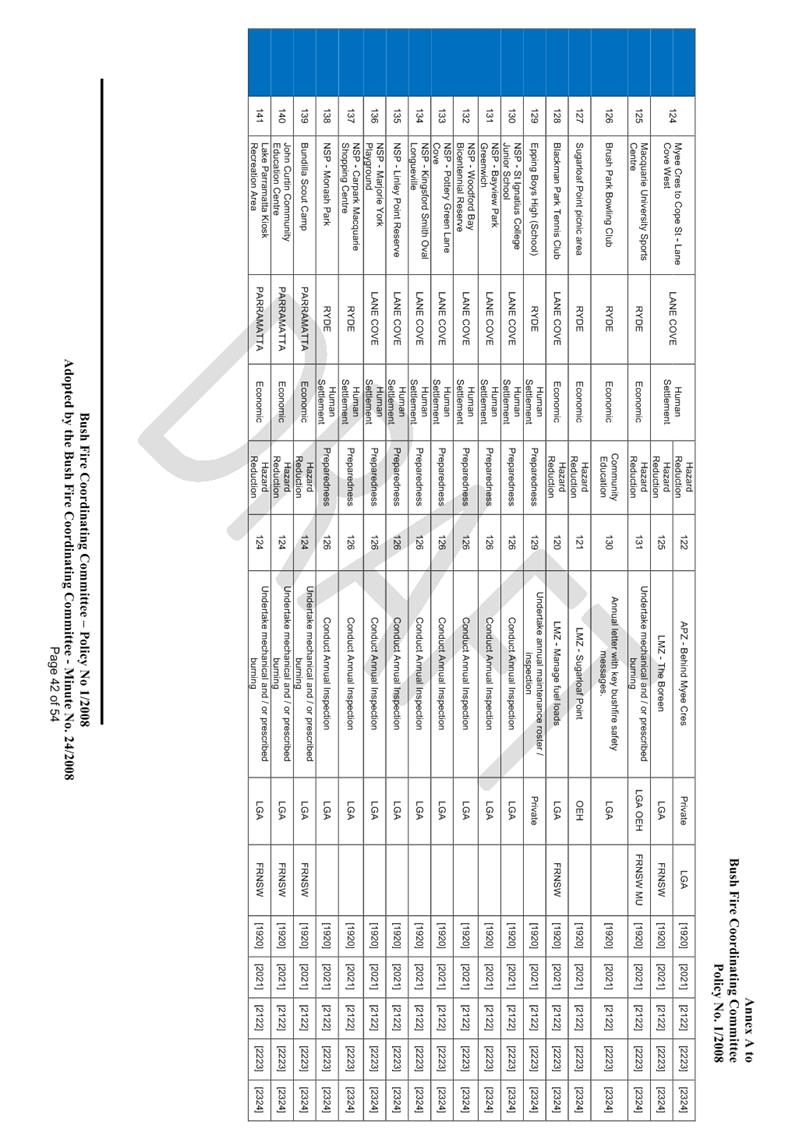
each asset and assigns treatments designed to mitigate the risk. Assets in the
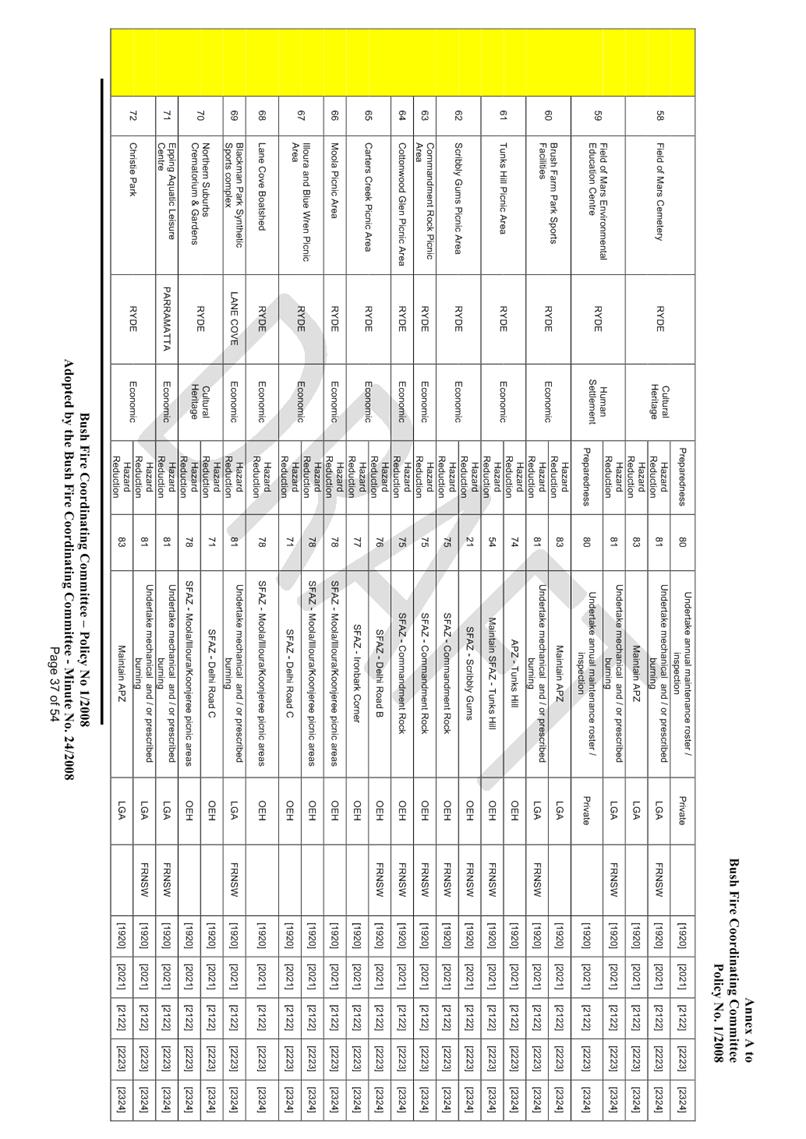
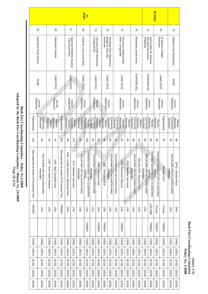
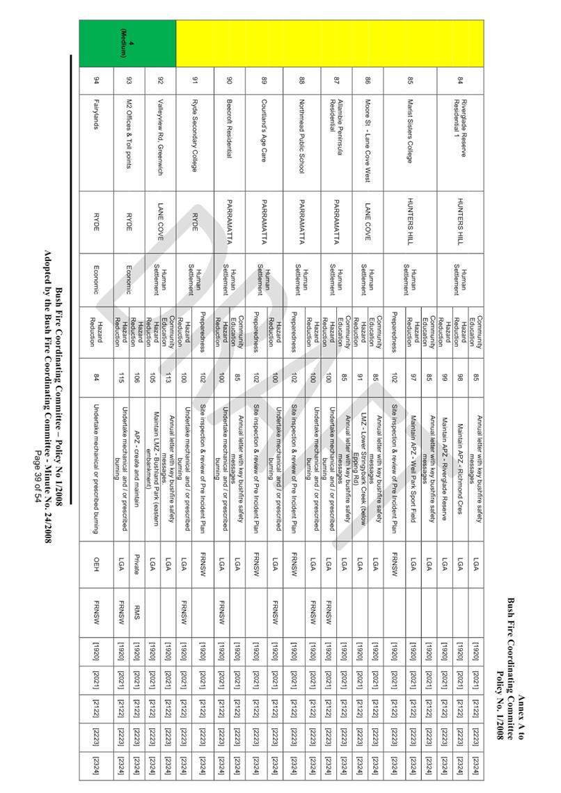
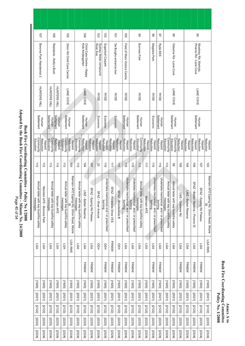
BFMC area identified as requiring treatments are listed in the assets table
(refer to Appendix 2 asset register). Other assets within the BFMC area that
were assessed as not requiring treatments within the life of this plan are
listed in the appendix to the BFRMP document. The Map Ref number
“NA” denotes non-spatial assets (refer to Appendix 4 Maps Display
Area Map 2).
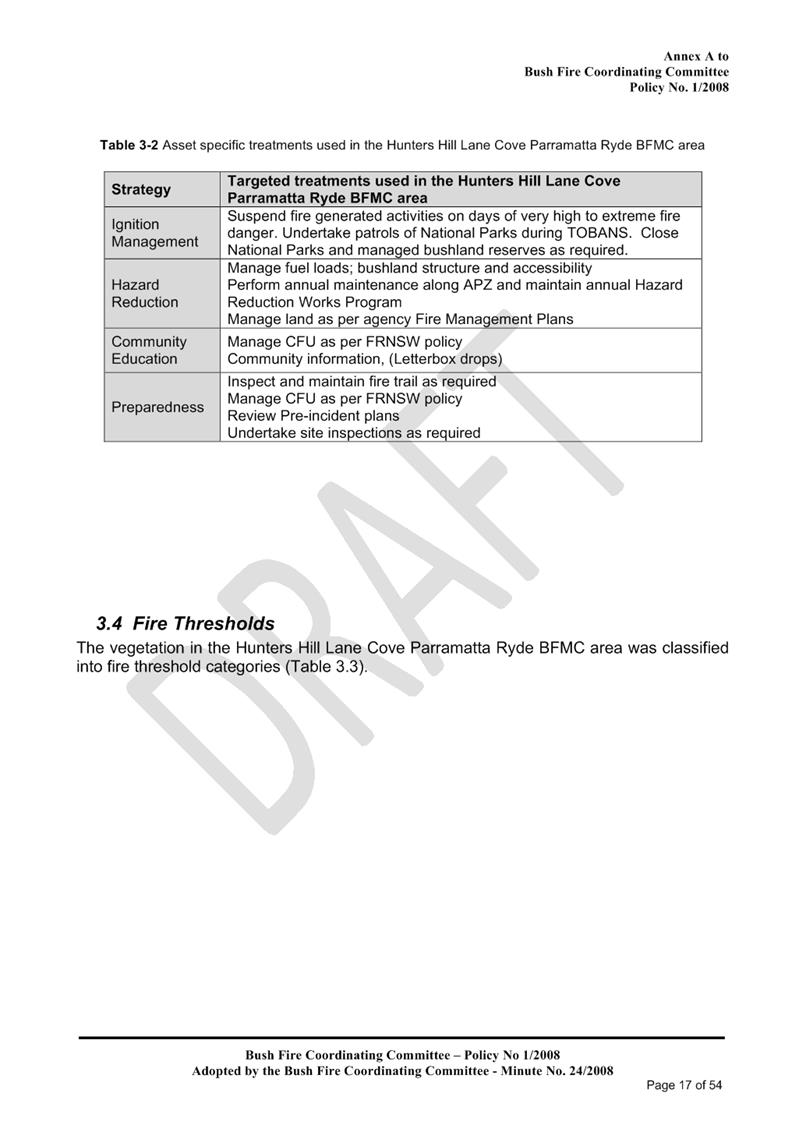
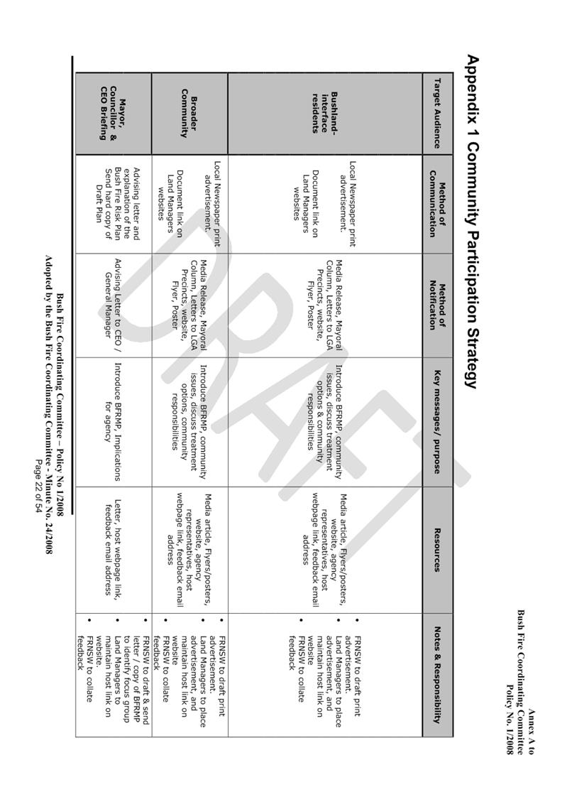
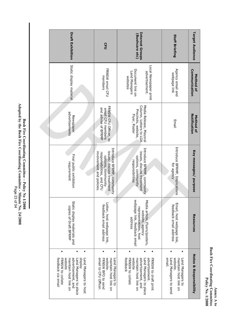
Specific treatments
assigned to assets in the Hunters Hill, Lane Cove Parramatta, Ryde area are
listed in the treatments table (refer to Appendix 3 Treatment Register) and
linked to the assets which they are designed to protect. Standard BFMC wide
treatments (i.e. not linked to specific asset) which occur on an ongoing basis
within the BFMC area are:
- Reviewing the bushfire
prone land map.
- Ensuring developments
in the bush fire prone land comply with Planning for bushfire protection
- Using the Local
Environment Plan/s (LEPs) to control development in areas which a bushfire risk
- Varying the standard
bushfire danger period as required
- Requiring permits
during bushfire danger periods
- Prosecution of
arsonists/offenders
- Investigation of
bushfire cause
- Normal fire
suppression activities
- Assessing and managing
compliance with strategic fire fighting resource allocation management systems
- Preparation of a S52 Operations
Coordination Plan.
The Rural Fire Service
identifies the need for Asset Protection Zones (APZ’s) in Lane Cove
bushland reserves on a case by case basis. The RFS advises Council of
requirements for individual APZ’s and Council staff undertake the
necessary on-ground works, including long term maintenance works. Hazard
reduction clearing in Council’s bushland reserves is carried out by
Council staff and contractors as required as part of the ongoing bush
regeneration program.
Community Consultation
Statement of Intent
The consultation is
designed to inform the community of the Bush Fire Risk Management Plan
2019/20. Any comments received will be reviewed and evaluated to
determine whether any revisions are required to the plan prior to adoption.
Method
|
Level of Participation
|
Inform
|
|
Form of Participation
|
Open
|
|
Target Audience
|
Lane Cove Community
|
|
Proposed Medium
|
Public
Exhibition, Council Website and email.
|
|
Indicative Timing
|
19th November – 30th
December 2019
|
|
RECOMMENDATION
That:-
1. Council endorse the
draft BFRMP 2019/20 for the purpose of public exhibition and consultation be
undertaken for a period of 42 days as outlined in the report and;
2. A further report is
submitted to Council following the exhibition period, to consider the final
plan for adoption.
|
Martin Terescenko
Executive Manager - Open Space and Urban Services
Open Space and Urban Services Division
ATTACHMENTS:
|
AT‑1View
|
Draft Bush Fire Risk Management Plan 2019 - 2024
|
54 Pages
|
|
|
ATTACHMENT 1
|
Draft Bush Fire Risk Management Plan 2019 - 2024
|


Ordinary Council Meeting 18 November 2019
Planning Proposal 36 -
166 Epping Road, Lane Cove West
Subject: Planning Proposal 36 - 166 Epping Road, Lane Cove West
Record No: SU7607 - 63699/19
Division: Environmental
Services Division
Author(s): Lara
Fusco; Christopher Pelcz
Executive Summary
On 30 August
2019, Council received Planning Proposal 36 from Ingham Planning Pty Ltd to
amend the Lane Cove Local Environmental Plan 2009 (LCLEP2009) to rezone land
located at 166 Epping Road, Lane Cove West, from IN2 TO B4 Mixed Use.
A Voluntary
Planning Agreement (VPA) letter of offer was also submitted. However,
Council’s policy is that any VPA be assessed separately at a later stage
to ensure that any Planning Proposal is considered on its own merits.
The Proposal was
referred to the Lane Cove Local Planning Panel (LCLPP) for advice on the 7
November 2019. In accordance with Section 9.1 of the EP & A Act, staff
prepared an assessment report with recommendations in relation to the Planning
Proposal including whether or not the proposal should be forwarded to the
Minister for a Gateway Determination. The Panel was requested to review and
consider relevant issues and amendments proposed by the proponent along with
the views and concerns raised in the staff report (AT-1).
The LCLPP
advises that Planning Proposal No 36 is not supported and should not proceed to
the Gateway Determination.
It is
recommended that Planning Proposal No. 36 be rejected and not be forwarded to
the Minister for a Gateway Determination. Having regard to the
advice of the Lane Cove Local Planning Panel (AT-2).
Background
The Site
The subject site at 166 Epping Road, Lane Cove West
comprises 1 parcel of land with a total area of approximately 9,128 m2 (approximately 0.91 ha) and is outlined in red in Figure
1. The site forms part of the Lane Cove West Light
Industrial area.
The existing
development comprises a 3-storey commercial building above 2 levels of partial
basement parking and is a lawful commercial use operating under existing use
rights. The lot is owned by Epic
Doncaster Ltd and is currently occupied by multiple commercial tenancies.
Existing access to the site is available for private vehicles and
pedestrians from Epping Road, or alternatively via a private road which may be
accessed off of Sam Johnson Way. The site adjoins Epping Road (M2) along the
north-western boundary.
Adjoining
development to the north of the site the Ingredion flour mill at 170 Epping
Road, and to the south-western boundary is the Arise Meriton residential tower
development at 150-158 Epping Road. The adjoining uses
to the north of the site are analogous with the light industrial zoning.
Adjoining the subject site to the east is
the Lane Cove Bushwalk and public pedestrian network including the Great
Northern Walk.
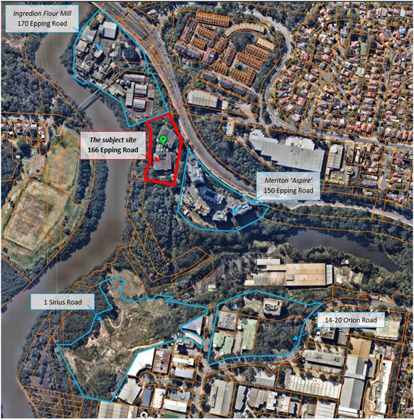
Figure 1: The
subject site, 166 Epping Road, is highlighted in red
(Source:
Nearmaps, 2019).
The Proposal for PP36
The proponent
seeks to:
· Rezone the site from IN2 Light Industrial to B4 Mixed Use;
· Increase the FSR from 1:1 to 4:1; and
· Increase the maximum height of building from 18m (5 storeys) to 87m
(24 storeys).
The proposed
mixed-use development would result in:
· Two (2) residential towers comprising a South and North tower,
twenty-one (21) storeys and fourteen (14) storeys respectively, above the three
(3) storey commercial podium. The towers have a maximum of 750 m2 of
residential GFA per floor and include private landscaped areas and communal
rooftop open spaces. The indicative dwelling mix for the proposed 316
apartments in both towers is approximately:
o 30% - 1 bedroom,
o 46% - 2 bedroom, and
o 24% - 3 bedroom.
· The three (3) storey employment base podium would comprise of
multiple commercial and retail tenancies;
· Five (5) levels of basement car parking with 512 allocated parking
spaces for the residential and commercial uses;
· Vehicular access into basement parking is via an existing right of
carriage way. The proposal also includes a deceleration lane along Epping Road
to access the site; and
· A public plaza and landscaped outdoor open space areas with
east-west site pedestrian walkways (connecting to the proposed elevated canopy
walkway and walking trails along Lane Cove Bushwalk as part of a VPA).
Discussion
Referral to
Local Planning Panel
Planning
Proposal 36 for and industrial site at 166 Epping Road was referred for advice
to the Lane Cove Local Planning Panel, under Clause 9.1 of the EP&A Act
1979. The Panel was requested to review and consider issues and amendments
proposed by the proponent along with the views and concerns raised in a staff
report (AT-1).
The Report to
the Lane Cove Planning Panel examines the detailed provisions of the
proponent’s Planning Proposal against the strategic and site-specific
merit test as well as other relevant matters. The discussion is contained
within this report (see AT-1).
In general
terms, the matters for consideration that are addressed are:-
· Strategic Merit test;
· Inconsistency
with Section 3.8 (Implementation of Strategic Plans) of the NSW
Environmental Planning & Assessment Act 1979;
· Site-specific merit test;
· Other
related matters, including
o The
site’s designation as ‘Employment lands’,
o Isolation from
social and community infrastructure (existing and proposed),
o Not located
within an accessible commuting distance of a strategic or local centre,
o Lack of
appropriate entry/egress routes,
o Impacts on
district views from adjoining Local Government Areas.
At the meeting,
Council staff provided a broad overview of Planning Proposal 36. The proponent
addressed the Panel.
Following this,
the Panel deliberated and provided their considered advice in the form of
recommendations and reasons for their decision, see AT-2. The LPP
concurred with the staff’s assessment report and advised that Planning
Proposal No 36 is not supported and should not proceed to the Gateway
Determination.
Advice to
Council
In providing
their advice to Council (see AT-2), the Panel (LCLPP) unanimously
supported the findings in staff’s report and provided the following
additional commentary:
The Panel does not accept the applicant’s position
that the existing rights enjoyed by the site for commercial use justify
rezoning the site from IN2 Light Industry to B4 Mixed Use. To the contrary, the
Panel considers that the opportunity cost of rezoning the land must be
considered in the planning and economic context of the medium and longer term.
The current use of the site for commercial purposes does
not overcome the powerful strategic imperatives of the adopted Regional and
local strategies. In particular, the proposal conflicts with Action 46 of the
North District Plan which acknowledges “the need to retain and manage
industrial and urban services land and prevent the conversion of land to
residential development, including mixed use zonings”.
It is acknowledged that, in their submission to the Panel,
the Proponent offered to retain the quantum of floor space available for
commercial use in any new mixed development. However, the Panel considers that
the use of such floorspace would be heavily constrained by the B4 zone and the
existence of residential apartments above.
It is also relevant to note that the Lane Cove LGA has
exceeded its residential targets for 2020 and will continue to do so based on
approvals issued and future developments which are in the pipeline. It is
therefore considered that there is no demand for additional residential land
within the LGA in the foreseeable future.
The Panel considers that it has not been demonstrated that
the loss of industrial land is warranted for the LGA or Region in a strategic
planning context.
In addition to the lack of strategic merit, the Panel notes that the
site is constrained by limited access, bushfire hazard, potential contamination
and the existence of heritage items adjacent to the site.
Conclusion
In conclusion,
the proponent’s planning proposal is not consistent with the Strategic
and Site-specific merit tests, as well as additional economic, social, and
traffic considerations raised by the Proposal.
Having regard to
the above, it is recommended that Planning Proposal No 36 not be supported and
not proceed to the Gateway Determination.
|
RECOMMENDATION
That having considered the advice of the
Lane Cove Local Planning Panel meeting of 7 November 2019, Council rejects
Planning Proposal No. 36 in full and such not be forwarded to the Minister
for a Gateway Determination, as it:-
A. Fails the strategic merit test.
Reasons:
1) The Planning
Proposal is not consistent with Objective 23 (and Action 11) of
the Greater Sydney Commission’s, ‘A Metropolis of Three
Cities’ which is to preserve and manage industrial and urban
services land.
2) The Planning Proposal is not
consistent with the following aspects of the North District Plan:
a) Planning Priority N11
which is to retain and manage industrial & urban services land.
b) Principles for managing
industrial and urban services land.
c) Action 46 which is to
retain and manage industrial and urban services land and preventing
conversion of the land to residential development, including mixed use
zonings.
3) The Planning
Proposal is not consistent with objectives 8 and 21 of the Lane
Cove Community Strategic Plan (LCCSP), as the proposal is not
consistent with the community priorities and actions for housing supply and
retention of commercial land.
4) The Planning
Proposal is not consistent with Planning Priorities 3, 5 and 7
of the Draft Lane Cove Local Strategic Planning Statement (DLSPS).
The site is not identified as a strategic precinct, nor is it considered an
appropriate area for housing.
The Lane Cove West employment lands are specifically identified in
the DLSPS to be protected and managed for industrial and commercial land
uses.
5) Given that the strategic planning
documents (i.e. A Metropolis of Three Cities and North District
Plan) identify this site as an area for employment growth (existing and
proposed), the existing planning controls are considered appropriate.
B. Inconsistent with Section 3.8 of the
Environmental Planning and Assessment Act
Reason
This section of the Act deals with the ‘Implementation of
Strategic Plans’ which requires all Planning Proposals to ‘give
effect’ to any applicable district strategic plan.
Given the direct inconsistency with Planning Priority N11 and
Action 46 of the North District Plan, dated March 2018, the Planning
Proposal does not ‘give effect’ to the North District Plan.
C. Fails the site-specific merit test.
Reasons:
6) The Planning Proposal has not
satisfactorily addressed SEPP 33 – Hazardous and Offensive Development
and SEPP 55 – Remediation of Land. The proponent’s Planning
Proposal does not consider the potential impacts of air pollution from
multiple sources including the adjoining Ingredion flour mill and the Lane
Cove Tunnel Air Vent Stack.
7) The rezoning of the site to permit residential land uses would
compromise future IN2 Light Industrial uses in the precinct and would likely
result in land use conflicts with surrounding industrial properties.
8) The Planning Proposal actually
reduces the amount of employment floorspace to less than the current maximum
permissible FSR of 1:1 – thus resulting in a net loss of employment floor
space. This will restrain future employment growth in a potential reduction
of commercial floorspace and associated employment density/yield.
D. Fails to consider Other Related Matters
9) The Department of Planning,
Industry, and Environment has identified and mapped the subject site as an
‘employment lands precinct’, as it is a valuable contributor to
the ‘Eastern Economic Corridor’.
10) The subject site is
isolated from social and community infrastructure, both existing and planned,
as it is not located within an accessible commuting distance of a strategic
or local precinct.
11) Only one entry/egress
route is available, which is a risk to emergency vehicles under Rural Fire
Service policies, and only one entry for pedestrians into the site.
12) The Planning proposal would further compromise
district views from adjoining Local Government Areas, Willoughby and City of
Ryde including the National Park.
E. That
Council notify the applicant of its decision in writing as soon as
practicable.
|
Michael Mason
Executive Manager
Environmental Services Division
ATTACHMENTS:
|
AT‑1View
|
Report to Local Planning Panel - 166 Epping Road Planning
Proposal - 7 November 2019
|
18 Pages
|
|
|
AT‑2View
|
Advice from Local Planning Panel - 166 Epping Road
Planning Proposal - 7 November 2019
|
3 Pages
|
|
|
AT‑3View
|
Planning Proposal Report
|
51 Pages
|
Available Electronically
|
|
AT‑4View
|
Site Survey Plan
|
1 Page
|
Available Electronically
|
|
AT‑5View
|
Urban Design Study
|
89 Pages
|
Available Electronically
|
|
AT‑6View
|
Concept Design
|
83 Pages
|
Available Electronically
|
|
AT‑7View
|
Traffic and Parking Impact Assessment
|
55 Pages
|
Available Electronically
|
|
AT‑8View
|
Economic Impact Assessment
|
42 Pages
|
Available Electronically
|
|
AT‑9View
|
Bushfire Constraints and Opportunities Report
|
25 Pages
|
Available Electronically
|
|
ATTACHMENT 1
|
Report to Local Planning Panel - 166 Epping Road Planning Proposal
- 7 November 2019
|
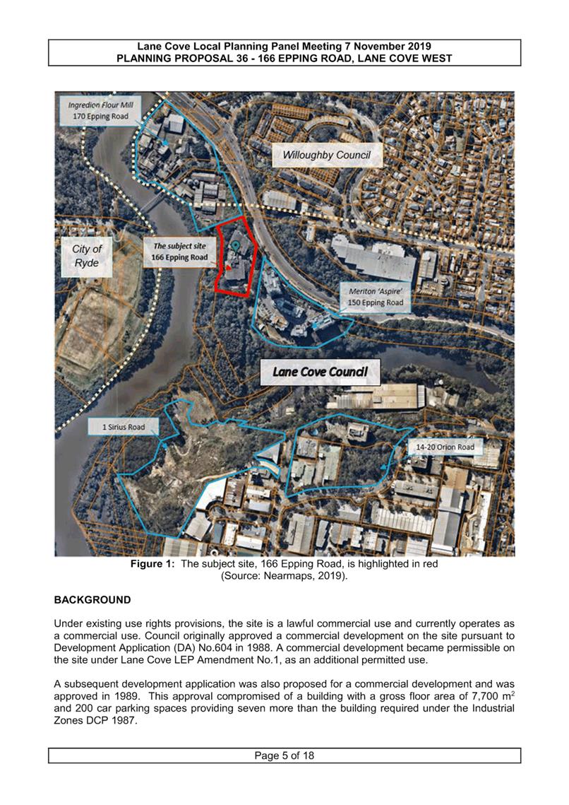
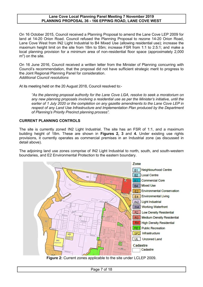
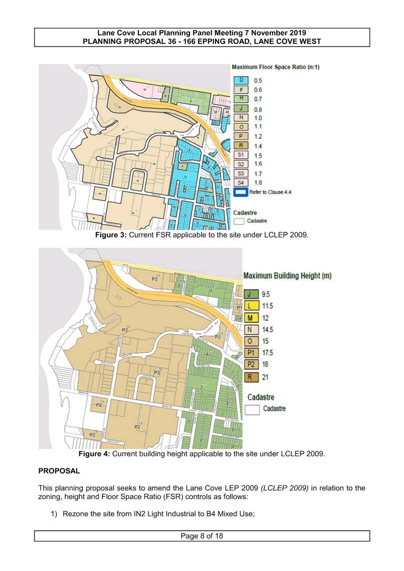
|
ATTACHMENT 2
|
Advice from Local Planning Panel - 166 Epping Road Planning
Proposal - 7 November 2019
|
Ordinary Council Meeting 18 November 2019
Planning Proposal 37 -
St Leonards Plaza Additional Permitted Use
Subject: Planning Proposal 37 - St Leonards Plaza Additional Permitted
Use
Record No: SU7691 - 63704/19
Division: Environmental
Services Division
Author(s): Terry
Tredrea; Lara Fusco; Christopher Pelcz
Executive Summary
The
purpose of this report is to consider the planning merits and provide advice on
a planning proposal to amend Lane Cove Local Environmental Plan 2009 (LCLEP
2009) to include Recreation Area as an additional permitted use in the
SP2-zoned land along the rail line at St Leonards.
Given
the minor ‘housekeeping’ nature of the amendment, Planning Proposal 37 does not require supporting
documentation or studies.
Planning
Proposal 37 was referred to the Lane Cove Local Planning Panel (LCLPP) for
advice on the 7 November 2019. In accordance with Section 9.1 of the EP & A
Act, staff prepared an assessment report setting out recommendations in
relation to the Planning Proposal including whether or not the proposal should
be forwarded to the Minister for a Gateway Determination. The Panel was
requested to review and consider relevant issues and amendments proposed by the
proponent along with the views and concerns raised in the staff report (AT-2).
The LCLPP advises that Planning Proposal No
37 is supported and should proceed to the Gateway Determination.
It is therefore recommended that Planning
Proposal No.37 be supported in full and be forwarded to the Minister for a
Gateway Determination. This is consistent with advice from the Lane Cove Local
Planning Panel (AT-3).
Background
The site
The site is situated
within the Lane Cove Local Government Area (LGA) adjacent to the boundary of
the Willoughby LGA roughly 5km from Sydney CBD.
The site is within close
proximity to the St Leonards Station which is located immediately to the north
of the site (see figure below).

Figure 1: The site
The site subject for
this proposal is the North Shore Railway Line at St Leonards. It is located on
the southern side of the Pacific Highway across from the St Leonards Railway
Station and the Forum mixed use development.
Proposal
The Planning Proposal seeks to amend Schedule 1 of the Lane
Cove Local Environmental Plan. This will introduce a site-specific additional
permitted use (Recreation Area), without development consent.
Overall, the Proposal would not result in any change to
existing planning controls for the site near its surrounding zonings.
The intent of the
Planning Proposal is to facilitate development of the site for the Over-Rail
plaza which has been in Council’s plans since 2011. The proposed plaza development would include
construction of the deck across the air space about the rail corridor and
associated works.
Discussion
Referral to
Local Planning Panel
Planning
Proposal 37 was referred for advice to the Lane Cove Local Planning Panel,
under Clause 9.1 of the EP&A Act 1979. The Panel was requested to review
and consider issues and amendments proposed by the proponent along with the
views and concerns raised in a staff report (AT-2).
The Report to
the Lane Cove Planning Panel examines the detailed provisions of the
proponent’s Planning Proposal against the strategic and site-specific
merit test as well as other relevant matters. All of the discussion is
contained within this report (see AT-2).
In general
terms, the matters for consideration that are addressed are:-
· Strategic Merit test; and
· Site-specific merit test.
At the meeting,
Council staff provided a broad overview of Planning Proposal 37 and suggested
that the Draft Planning Proposal’s clause for Schedule 1 be amended to
the following:-
Use
of certain land being the North Shore Line on the southern side of Pacific
Highway at St Leonards
1. This clause applies to land
known as Part Lot 1 DP 127019, being the North Shore Rail line on the southern
side of Pacific Highway, bound by Canberra Avenue and Lithgow Street.
2. Development for the
purposes of a Recreation Area is permissible without consent.
Following this,
the Panel deliberated on the PPs and provided their considered advice in the
form of recommendations and reasons for their decision, see AT-3. The
LPP concurs with staff’s recommendations, and advises that Planning
Proposal No 37 is supported and should proceed to the Gateway Determination.
Advice to
Council
In providing
their advice to Council (see AT-3), the Panel unanimously supported the
findings in staff’s report. The Panel also added the following
commentary:
The Panel notes that this planning proposal will facilitate
the provision of high quality open space within the airspace above the rail
corridor by permitting development for the purposes of a recreation area on the
site.
The Panel considers that the project is an outstanding
example of innovation in planning for community facilities which may also have
relevance to similar localities in other local government areas. As
Sydney’s population continues to grow with increasing density around
transport nodes, the opportunities to provide local open space become far more
challenging.
Lane Cove Council is to be commended for this innovative
approach to providing high quality open space in a precinct where there is no
opportunity for additional land to be reserved for public purposes.
The Panel supports the planning proposal with the amendment (as
provided to the Panel) to include the site within Schedule 1 of Lane Cove LEP
2009 to permit development for the purposes of a recreation area without
consent.
Conclusion
Planning Proposal 37 is consistent with the
Strategic and Site-specific merit test and the recommendations of the St
Leonards/Crows Nest Draft 2036 Plan.
Having regard to the above, the Lane Cove
Local Planning Panel, at its 7 November 2019 meeting, recommended that Planning
Proposal 37 be supported (with its amendments) and that it proceed to Gateway
Determination. It is recommended that Council adopt the recommendations of the
Panel in full.
|
RECOMMENDATION
That having considered the advice from
the Lane Cove Local Planning Panel meeting of 7 November 2019, Council
supports the amended Planning Proposal No. 37 in full and be forwarded to the
Minister for a Gateway Determination, as it is:-
A. Consistent
with the Strategic Merit test
Reasons
1) The
Planning Proposal is consistent with Objective 31 and 32 of A Metropolis
of Three Cities, as it will provide new high quality open space in the
area which will interconnect with other green links being provided around the
site.
2) The
Planning Proposal is consistent with the site-specific Action 34 of the North
District Plan, as it will enable a development pathway to deliver this high
quality open space to the St Leonards precinct – thus achieving the
Actions intent.
3) The
Planning Proposal is consistent with the Place and Landscape Recommendations
of the St Leonards/Crows Nest Draft 2036 Plan for the area.
4) The
Proposal is consistent with the priorities and actions of all of
Council’s strategic planning documents (i.e. Draft Local Strategic Planning
Statement, Delivery Program and Operational Plan).
5) The
Planning Proposal also implements the recommendations of previous strategies
relevant to the area (i.e. St Leonards Strategy 2006).
B. Consistent
with the Site-Specific Merit test
Reasons
6) Delivery
of the Over-rail plaza will not impact upon any likely future uses
surrounding the area.
7) Proposed
construction is unlikely to impact on the infrastructure and ongoing
operation of the St Leonards Railway Line.
C. Council
forward Planning Proposal 37 to NSW Department of Planning, Industry and
Environment for a Gateway Determination.
|
Michael Mason
Executive Manager
Environmental Services Division
ATTACHMENTS:
|
AT‑1View
|
Planning Proposal - St Leonards Plaza
|
44 Pages
|
Available Electronically
|
|
AT‑2View
|
Report to Local Planning Panel - 7 November 2019
|
12 Pages
|
|
|
AT‑3View
|
ADVICE - Lane Cove Plaza use - Lane Cove Local Planning
Panel - 7 November 2019
|
2 Pages
|
|
|
ATTACHMENT
2
|
Report to Local Planning Panel - 7 November 2019
|

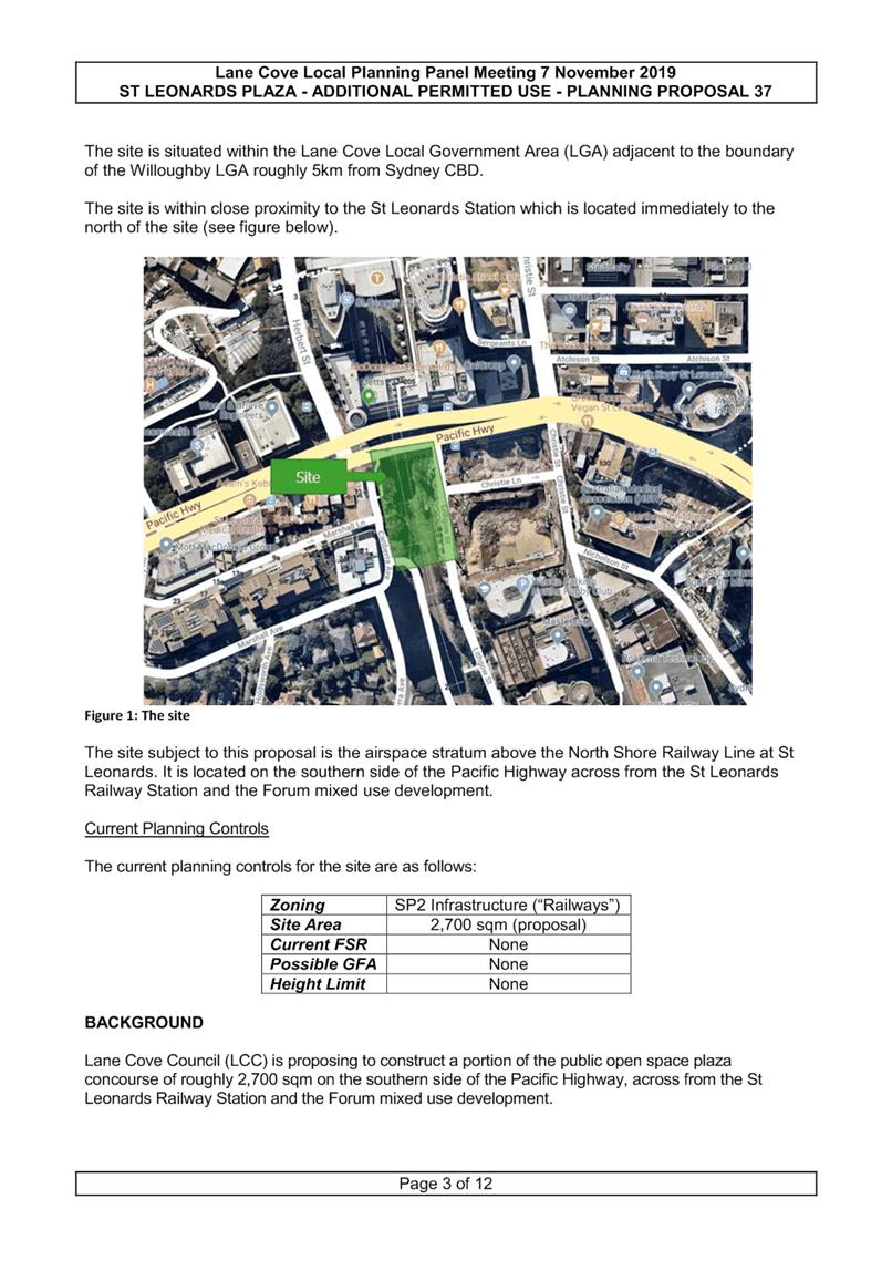
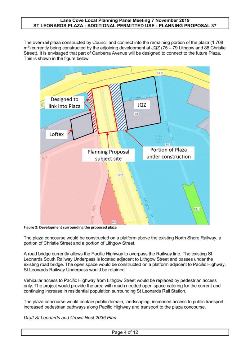
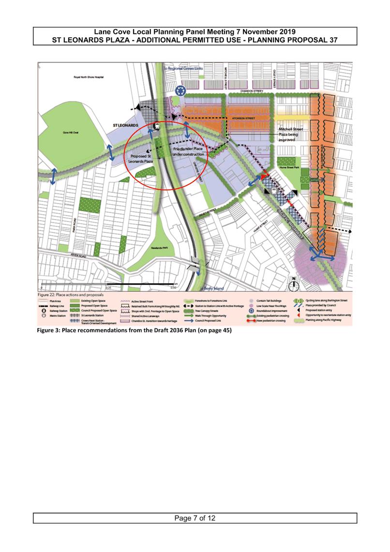
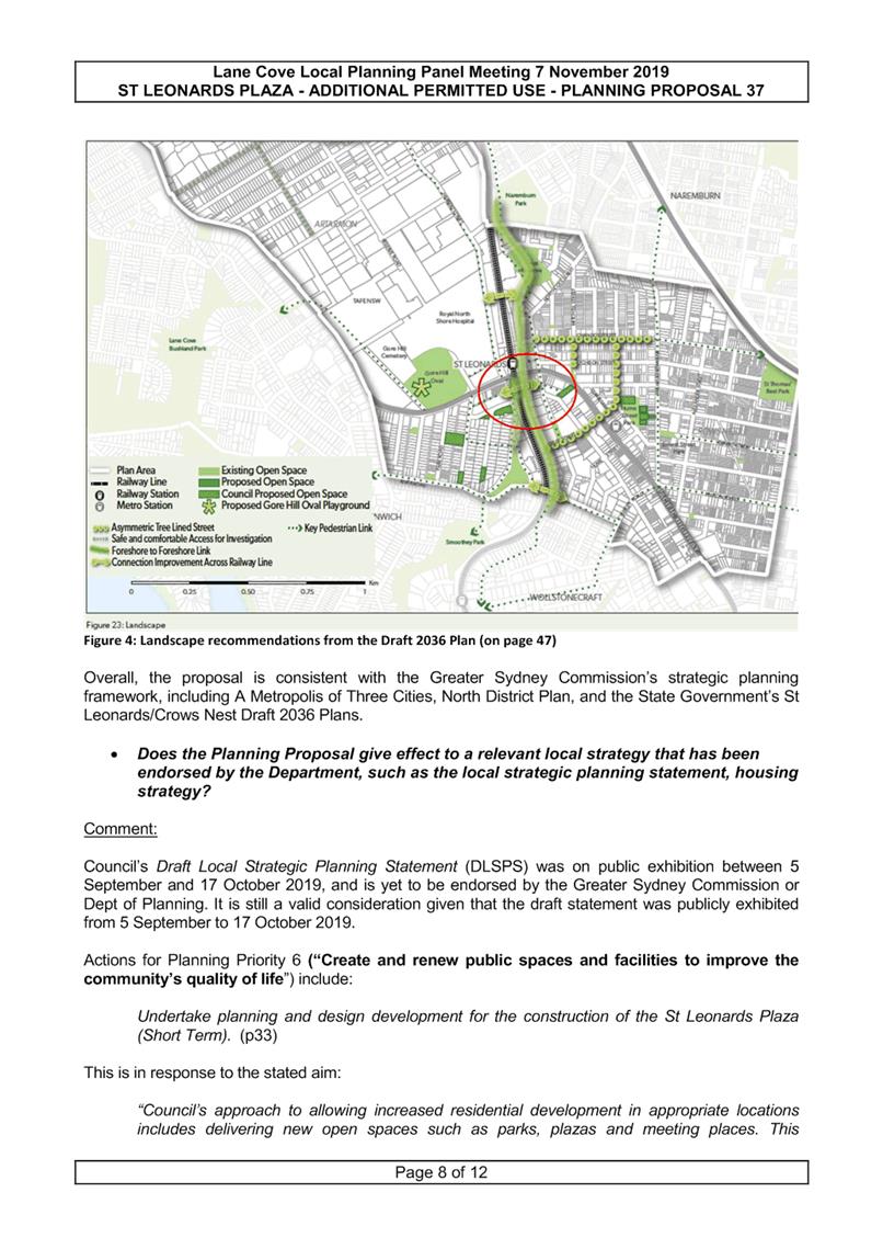
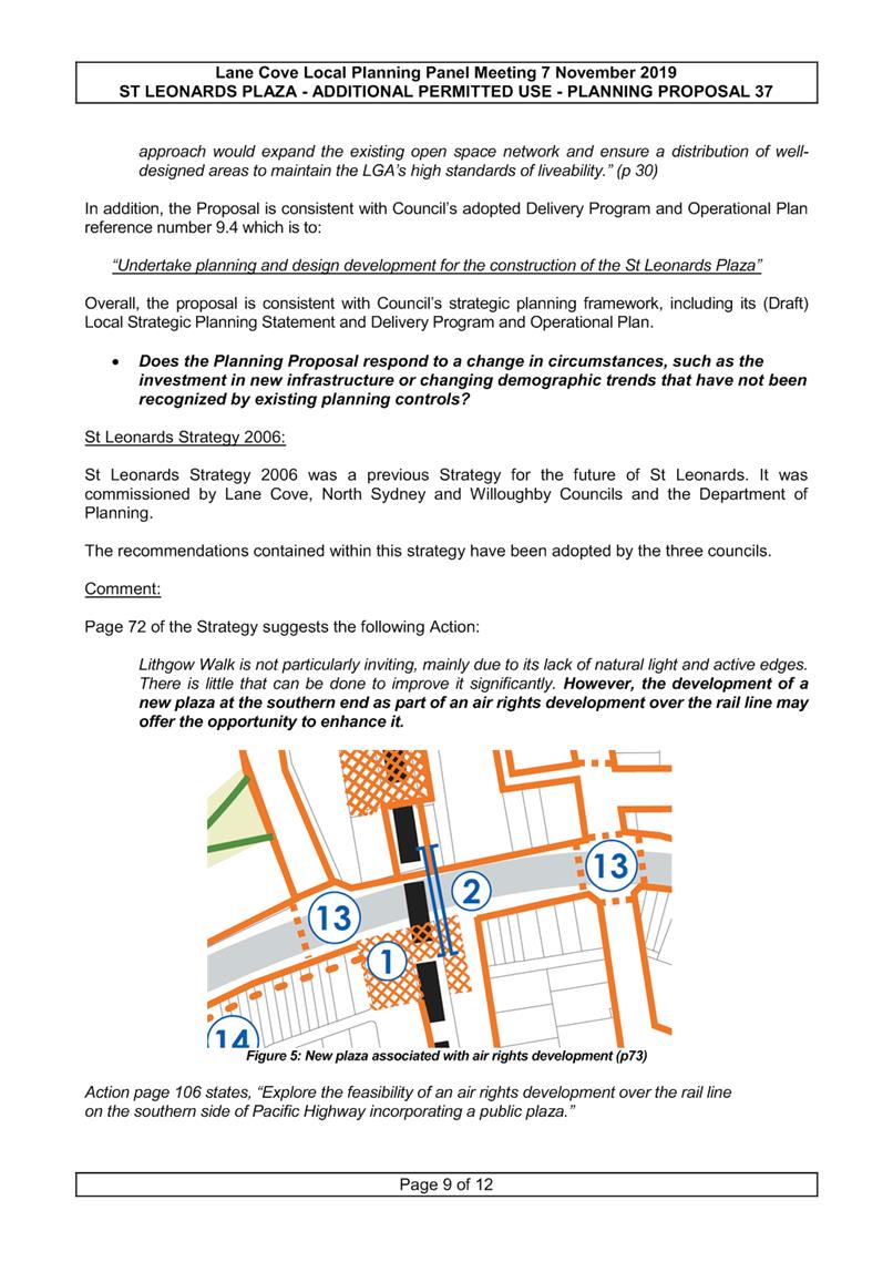
|
ATTACHMENT 3
|
ADVICE - Lane Cove Plaza use - Lane Cove Local Planning Panel - 7
November 2019
|
Ordinary Council Meeting 18 November 2019
New Pocket Park at 552
Mowbray Road - Djanaba Nura
Subject: New Pocket Park at 552 Mowbray Road - Djanaba Nura
Record No: SU7675 - 65139/19
Division: Open Space and
Urban Services Division
Author(s): Helen
Haigh
Executive Summary
Council has prepared a park concept design for the new
pocket park at 552 Mowbray Road. The land is sloping north south and provides
the opportunity to create spaces utilising the natural topography of the site.
The theme of the park is nature play and provides a space for play, solitude
and small family BBQ’s.
In preparing the design, Council staff has also researched
the local history and contacted the Aboriginal Heritage Office regarding a new
name for the park. The name Djanaba Nura (Laughter
Place) has been put forward as
the new name for the pocket park. It is recommended that consultation be
undertaken on the proposed design and name.
Background
552 Mowbray Road (697m2)
was acquired by Council under a Voluntary Planning Agreement (VPA) to be
developed as a pocket park to partially offset the loss of the Girraween Avenue
park, which was part of a land swap as part of Council’s overall strategy
to create the new large Mindarie Park. The Mowbray Road site was rezoned as RE1
Public Recreation in November 2019. The house was demolished in September 2019
and the site is now ready for construction to commence.
Discussion
Park Design
The pocket park is designed to cater for the
immediate local community. Nearby Mindarie Park is a high use park with a range
of active and passive activities. This small park will provide space for
passive activities such as seating, a small area for play incorporating a
nature-based theme and interactive play sculpture, and a BBQ with accessible
seating at the top of the park (AT-2).
Park Naming
Councils’
Local History Librarian has conducted research on 552 Mowbray Road and
surrounds. No significant history was found for the exact location, the full
report is attached (AT-1). The Aboriginal Heritage Office was also
contacted for a suitable name. Much of the Cammeraygal language has been lost,
however the name Djanaba Nura has been suggested, which translates to Laughter
Place.
To complete the naming process the
Geographical Names Board (GNB) must approve the proposed name. Council will
commence the process during the proposed consultation on the proposed design by
submitting the proposed name for initial feedback. If suitable, the Board
formally considers the proposal and if endorsed, will advertise the place name
and call for submissions. This submission period is open for 1 month.
Works will commence as soon as possible
after finalisation of the consultation, with hard landscaping planned to be
completed by 30 June 2020.
Community Consultation
Statement of Intent
The consultation is designed to
receive the community’s feedback on the proposed concept design plan. Any
comments received will be reviewed and evaluated to determine whether changes
should be made to the final park design.
Method
|
Level of Participation
|
Consult
|
Inform
|
|
Form of Participation
|
Open
|
Open
|
|
Target Audience
|
Lane Cove Community
|
Lane Cove Community
|
|
Proposed Medium
|
Notification letters to
neighbouring community, Public Exhibition,
Website Exhibition
|
Public
Exhibition,
Website
Exhibition,
|
|
Indicative Timing
|
Nov – Jan 2020
|
Nov – Jan 2020
|
Conclusion
552 Mowbray Road will be turned into a new
passive pocket park with the provision of BBQ and nature themed activity shown
in the concept plan (AT - 2) to cater for the surrounding local
community. Djanaba Nura is the suggested name for the new pocket park, which is
subject to the official Geographical Names Board process.
|
RECOMMENDATION
That:-
1. Council note endorse the concept plan for the purpose of community
consultation on the proposed pocket park at 552 Mowbray Road, Lane Cove;
2. Consultation be undertaken for a minimum of six (6) weeks as
outlined in the Consultation Strategy outlined in the report and a further
report be submitted to Council; and
3. Council commence the place naming process by submitting the new
park name for 552 Mowbray Road, Lane Cove to the Geographical Names Board for
consideration.
|
Martin Terescenko
Executive Manager - Open Space and Urban Services
Open Space and Urban Services Division
ATTACHMENTS:
|
AT‑1View
|
552 Mowbray Road Report
|
1 Page
|
|
|
AT‑2View
|
Djanaba Nura Concept Masterplan
|
1 Page
|
|
|
ATTACHMENT 1
|
552 Mowbray Road Report
|
|
ATTACHMENT 2
|
Djanaba Nura Concept Masterplan
|
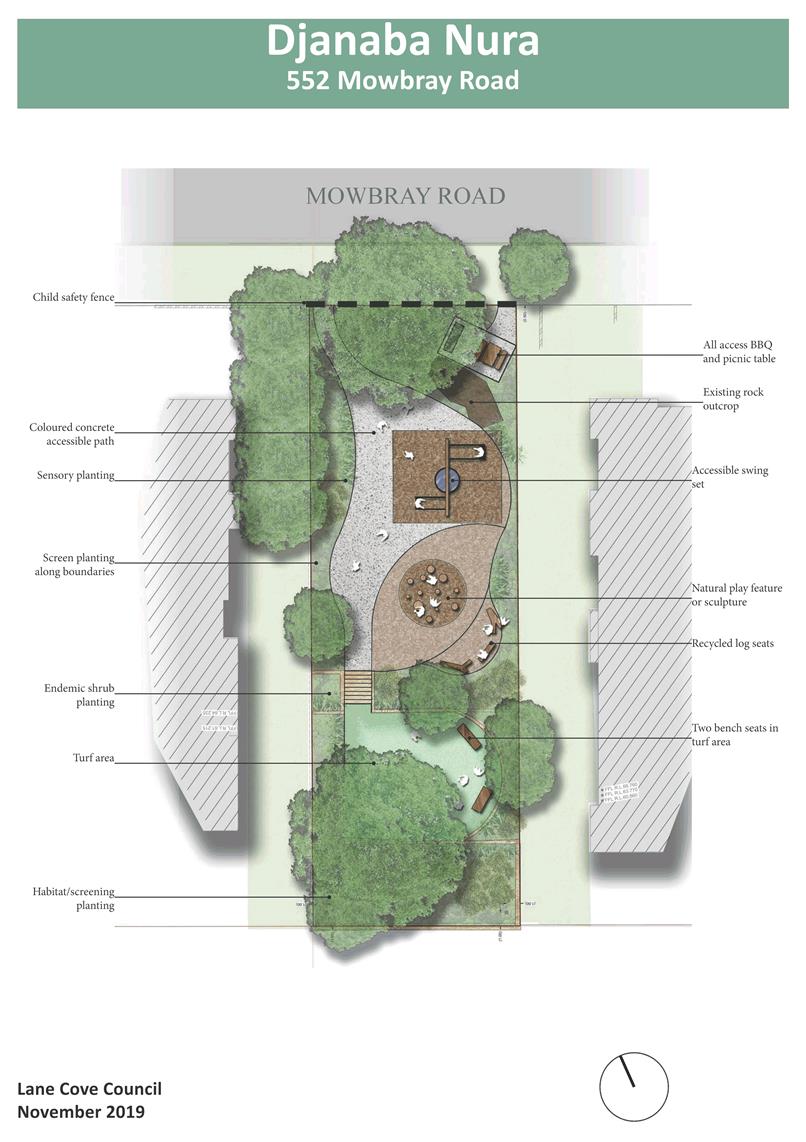
Ordinary Council Meeting 18 November 2019
New Park at 69
Longueville Road - Cammeraygal Park
Subject: New Park at 69 Longueville Road - Cammeraygal Park
Record No: SU5099 - 65197/19
Division: Open Space and
Urban Services Division
Author(s): Helen
Haigh
Executive Summary
A landscape design package including
concept plans through to specification documentation has been prepared for
Cammeraygal Park, at 69 Longueville Rd Lane Cove. The ‘gateway’
park has been designed with Aboriginal interpretation and culture as the key
theme.
The opening of The Canopy carpark will allow the current car
park to be converted to a small park. Construction is to start in January 2020
with completion by 30 June 2020.
Background
69 Longueville Road was previously a
car park leased by Council from the RTA, now RMS. Council was advised in early
2011 by the RTA that it was planning to auction the property. The land was
originally resumed for road widening purposes and the re-alignment of Epping
Road. Council considered a report about possible purchase of the site at its
meeting of 7 March 2011. Council resolved to authorise the General Manager to
attend the auction and purchase property up to a pre-determined amount, based
on an independent valuation obtained by Council. The property was subsequently
passed in at auction on 12 March 2011, with the bidding in the low one
millions.
In July 2011 Council wrote to the
Minister for Roads, the Hon Duncan Gay requesting the transfer of the land (69
Longueville Rd) to Council for development by Council
as a ‘gateway’ park to Lane Cove. As part of the process
Council’s Landscape Architect developed concept plans for the site with
Aboriginal interpretation and culture as the key objective, these plans were
presented to Council on 17 October 2011 and then placed on public exhibition
from November 2011 to February 2012.
The request of assistance from the
Minister of Roads, the Honorable Duncan Gay, was successful and the land was
subsequently offered for sale to Council in 2012. Council along with the owners
of 71 Longueville Road funded the purchase of the land in July 2014. A
condition of the sale required Council to turn it into a recreation/open space
area and parkland by December 2019 to allow its use as a car park until the
planned completion of the then Rosenthal Car Park redevelopment. Discussions
have taken place allowing an extension to June 2020.
To
facilitate completion of the project, Council engaged a Landscape Architect in
June 2019 to finalise and document the design of the park maintaining the
indigenous Australian theme having regard to the initial design and results of
the community consultation undertaken at the time.
Discussion
A landscape concept package
(July 2019) AT–1 and landscape construction package and technical
specifications (October 2019) have been prepared for Cammeraygal Park. The
design has incorporated an Aboriginal theme which is represented through a
variety of materials, shapes and native plant selection. As a gateway park it
offers a shady space to sit while recognising it will also be utilised as a
transition point from Lane Cove Village to Epping Road. A bicycle maintenance
stand with pump and work stand has been combined into a subtle side bay along
the popular Epping Road cycle-way.
Construction is planned to commence in January 2020, at this
time The Canopy Car Park will have opened, and the Park is due for completion
by 30 June 2020.
Conclusion
It is recommended that Council
adopt the concept plans for Cammeraygal Park and agree to the start date for
the construction of the park.
|
RECOMMENDATION
That Council receive and note the report
for Cameraygal Park.
|
Martin Terescenko
Executive Manager - Open Space and Urban Services
Open Space and Urban Services Division
ATTACHMENTS:
|
AT‑1View
|
Cameraygal Park - Design Concept
|
4 Pages
|
|
|
ATTACHMENT 1
|
Cameraygal Park - Design Concept
|
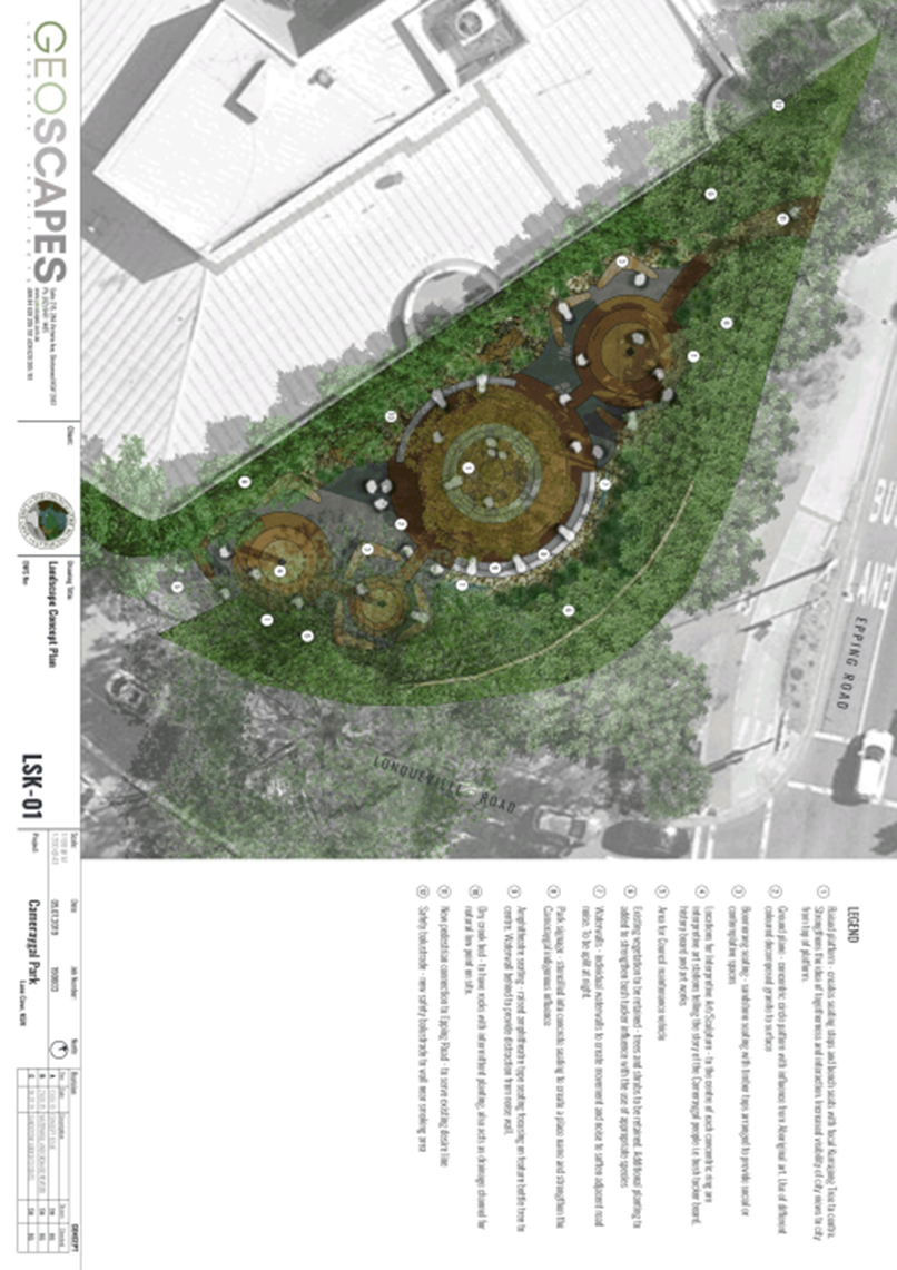
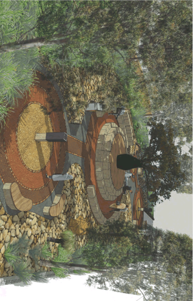
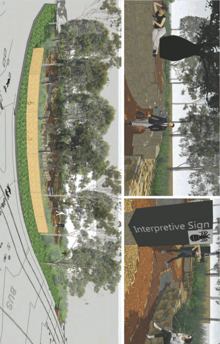
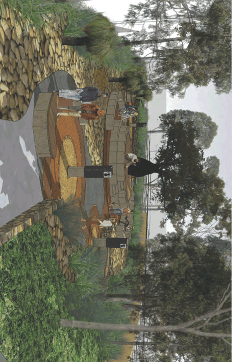
Ordinary Council Meeting 18 November 2019
Single-Use Plastic Bag
Reduction Program
Subject: Single-Use Plastic Bag Reduction Program
Record No: SU7238 - 64907/19
Division: Environmental
Services Division
Author(s): Fiona
McCleary
Executive Summary
At the Council Meeting on 17 June 2019,
Council resolved to implement a single-use plastic bag reduction program to
help businesses transition from unsustainable, disposable, single-use bags to
reusable and durable alternatives.
The program was implemented in September
and October 2019 in partnership with Macquarie University’s Student
Consultancy Program. Environmentally friendly bags were purchased via the
Sustainability Levy to the value of $3,460. Four hundred (400) bags were
provided to twenty-four (24) food outlets and accompanied with an awareness and
education campaign to encourage the phase out of single-use plastic bags.
As a result of the program, 33% of
businesses committed to ceased using single-use plastic bags.
Background
Council at its meeting on 17 June
2019 resolved that: -
“A report outlining the
results of the single use plastic bag reduction program be presented to Council
for the November 2019 meeting.
The plastic bag
reduction program began with a survey exploring bag usage patterns in one hundred and four (104) local food
businesses. After analysing the survey results, sixty-five (65) food businesses
were eligible to participate. Of these businesses;
· Twenty-four (24) businesses chose to participate in the trial
· Fifteen (15) businesses did not wish to participate in the trial
· Twenty-six (26) businesses did not use plastic bags
Twenty-four
(24) businesses were provided with four hundred (400) trial samples of either
paper bags or corn-starch bags, depending on what was most appropriate for
their needs.
The bags were
chosen as environmentally friendly alternatives to plastic bags due to their
recyclable, reusable and bio-degradable properties.
Discussion
The trial period
lasted three weeks. A post-trial survey was conducted to assess the
effectiveness of the campaign in assisting food outlets to transition from
single-use plastic bags.
Every
participating food outlet completed the post-trial survey.
Of these
businesses:
· 33% ceased using single-use plastic bags and are now providing more
sustainable alternatives
· 67% are yet to decide on whether they would make the permanent
transition to more sustainable bags.
Overall, the
plastic bag reduction program was well received, with comments from business
owners including:
“We
loved the project as it was a good starting point for our transition to
sustainable bags. We will not go back to plastic bags”. (Sushi Square)
“We
loved the bags and the quality was very good. We are now very interested in
further sustainable products. To Lane Cove Council: "Keep up the good
work"!” (The Junction)
“We
started to rethink our packaging”. (Kasina Eatery)
Fifteen (15)
customers were surveyed about the transition to eco-bags and 84% were either
very positive, or positive, about the change.
Where businesses
did not transition to eco-bags the main concerns prohibiting the change were
costs and durability.
To further
support the transition, all food outlets have been provided with: -
· A Lane Cove is on a Plastic Bag Diet poster to display in their
business (AT-1) and;
· An infographic to Skip the Plastic (AT-2)
· A Sustainable Supplier Guide which provides an independent summary
of different eco-bag options and suppliers (AT-3)
Conclusion
Council responded to growing community concern over single-use
plastics and effectively engaged local food outlets with proactive action that
provided alternatives with the aim of aligning their practices with community
expectations. The program has assisted local businesses with a transition to more
sustainable bags by providing free trial bags as well as a catalogue outlining
benefits of using eco bags, and a range of suppliers where they can be
purchased.
The Lane Cove is on a Plastic Bag Diet and Skip the Plastic
infographic connected environmentally concerned customers to businesses that
are improving their environmental performance by transitioning away from
single-use plastic bags.
|
RECOMMENDATION
That the report be received and noted.
|
Michael Mason
Executive Manager
Environmental Services Division
ATTACHMENTS:
|
AT‑1View
|
Lane Cove is on a Plastic Bag Diet
|
1 Page
|
|
|
AT‑2View
|
Skip the Plastic Infographic
|
1 Page
|
|
|
AT‑3View
|
Sustainable Supplier Guide
|
7 Pages
|
|
|
ATTACHMENT 1
|
Lane Cove is on a Plastic Bag Diet
|

|
ATTACHMENT 2
|
Skip the Plastic Infographic
|

|
ATTACHMENT 3
|
Sustainable Supplier Guide
|


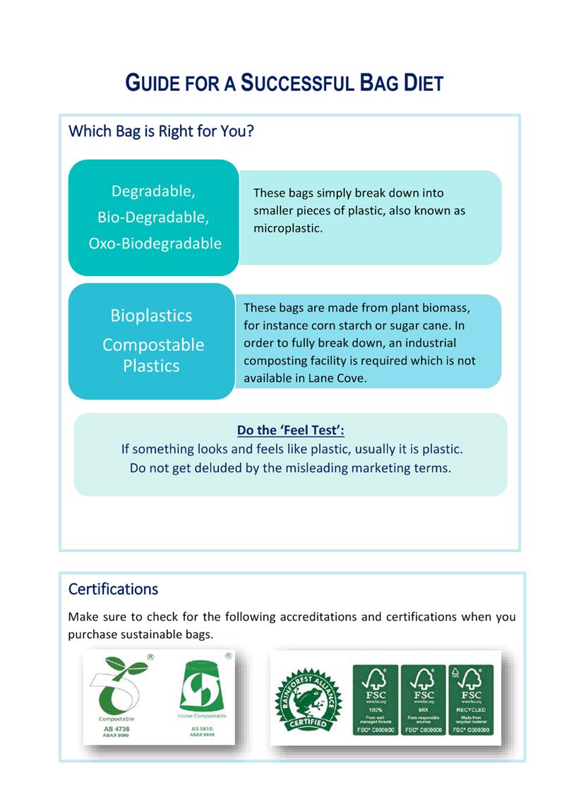

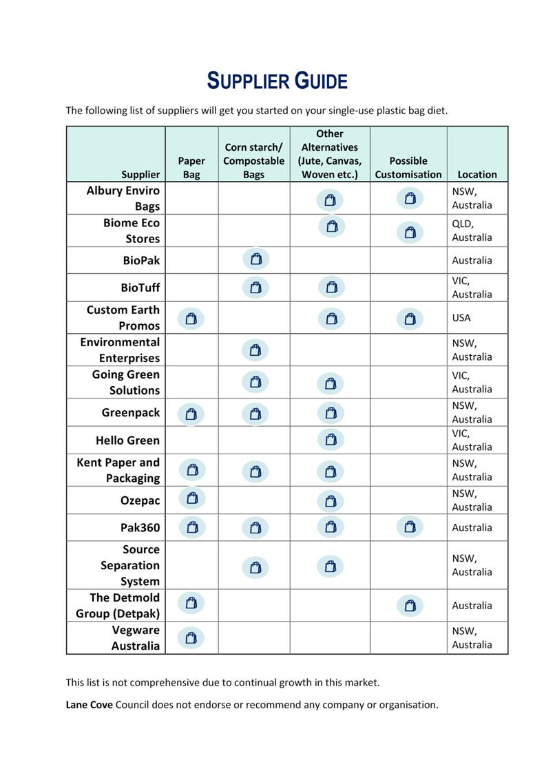
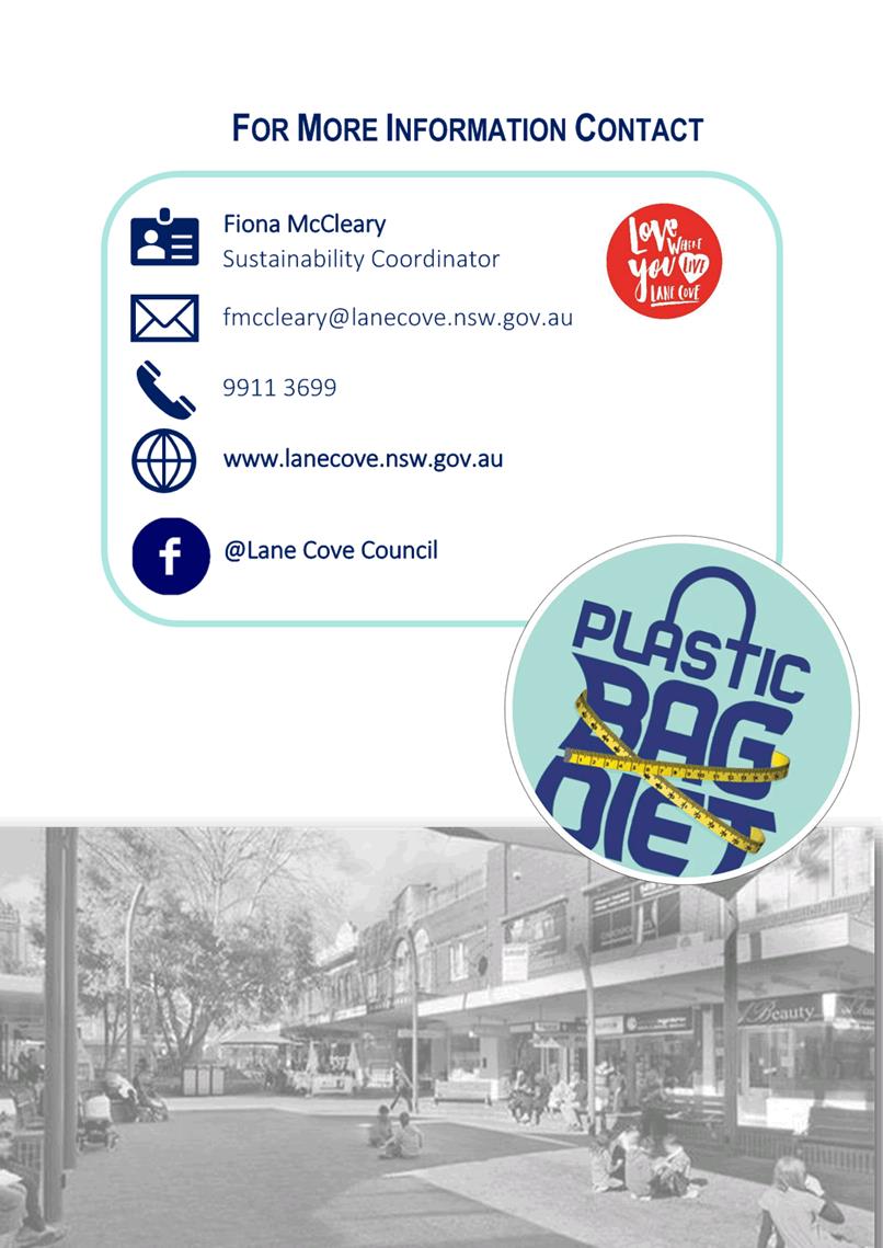
Ordinary Council Meeting 18 November 2019
Customer Experience
Strategy
Subject: Customer Experience Strategy
Record No: SU7520 - 67499/19
Division: Corporate Services
Division
Author(s): Jessica
Quilty
Executive Summary
The draft Customer Experience Strategy
(CES) has been developed to integrate traditional aspects of customer service
with a clearly defined pathway for new initiatives that will improve the
overall customer experience with Council. The intent is to align every point of
contact, process improvement and enhancement in technology in a clearly defined
roadmap that will achieve a great customer experience. The CES was discussed at
a Councillor workshop held on the 16 October 2019 where clarification was sort
on Council's outbound strategy, review of Council's website, additional methods
of communication and better utilization of social media. These matters were
clarified and the CES is now presented to Council for adoption.
Background
Council considered a post consultation
report at its meeting held on the 16 September 2019 where it resolved to:
1. Note
the post consultation report for the Customer Experience Strategy.
2. Address
the following matters in a Councillor Workshop:
a) Council
has been successfully taking inbound enquires via a mixed media. The next phase
of this program is an outbound Strategy to push information to the community.
The workshop investigate methods in which Council can take a proactive approach
to informing the community of items to reduce the volume of inbound queries.
For example, emergency works, oval closures etc.
b) Review
the recommended timeline to upgrade Council’s main website and identify
sources of funding that would be able to prioritise this project to commence in
the next 12 months.
c) Identify
additional methods of communication that can be included in the Customer
Experience Strategy to enhance Council’s interaction with residents.
d) Identify
how Council’s chosen social media channels can be better utilised to support
the Customer Experience Strategy.
3. Present
a final report to Council by December 2019 or earlier to finalise and adopt
Council’s Customer Experience Strategy.
Discussion
Many of the points raised in
Council’s resolution relate to Council’s overall communication
strategy are tools/options to be considered in the implementation of the CES.
To ensure customers receive the best communication and service the strategy
requires, a customer journey map is completed on individual service types. A
customer journey is the complete sum of experiences that customers go through
when interacting with a company or brand. Instead of looking at just part of a
transaction or experience, the customer journey documents the full experience
of being a customer. From this mapping, specific customer communication and
engagement methods are identified as well as system development and staff
training. All this is then filtered back to make up part of the overarching
Customer Experience Strategy (mainly through the key actions on pages 22 &
23). Council commenced journey mapping in 2018 and this has proven to be a
useful tool to gain insights
into common customer pain points, how Council can improve the customer
experience, and define what customers, and prospective customers, need in order
to complete a 'purchase'. Council intends to undertake journey mapping for all
its services.

Figure 1: Service
request lifecyle
As part of developing the CES,
Council staff developed a vision statement of providing ‘surprisingly
simple’ services to the community which ultimately represents the
avoidance of complex and bureaucratic process for customers in order to engage
with Council. Creating strong, positive experiences within the customer journey
will result in improvements to the bottom line by improving performance
throughout the journey at multiple touch points.
Council for some time
has been considering making various layout and search query changes to the
website. These changes are due for completion the next couple of weeks.
Conclusion
The
ultimate goal of the Strategy is to improve service quality, promote
transparent and efficient interaction, enhance the level of public trust in
government, and drive better community outcomes.
|
RECOMMENDATION
That Council adopt the Draft Customer Experience Strategy
dated November 2019 as attached at AT-1.
|
Jessica Quilty
Acting Executive Manager
Corporate Services Division
ATTACHMENTS:
|
AT‑1View
|
Draft Customer Experience Strategy
|
28 Pages
|
|
|
ATTACHMENT 1
|
Draft Customer Experience Strategy
|


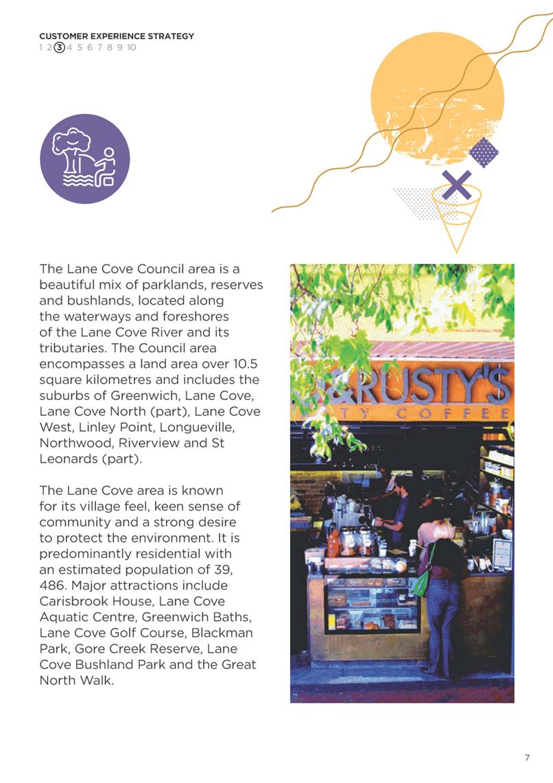


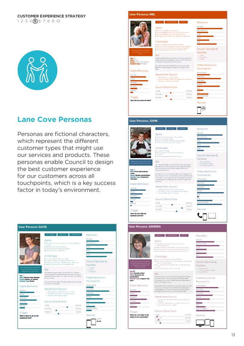


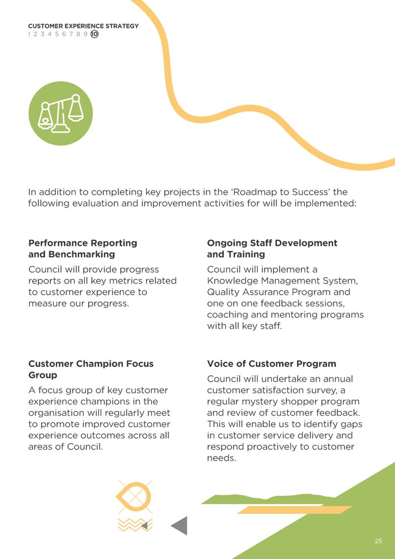

Ordinary Council Meeting 18 November 2019
Delivery Program and
Operational Plan - First Quarter Review
Subject: Delivery Program and Operational Plan - First Quarter
Review
Record No: SU1466 - 67544/19
Division: Corporate Services
Division
Author(s): Jessica
Quilty
Executive Summary
This report outlines the 1st
Quarter progress towards achieving the projects listed in the adopted 2019-2020
Delivery Program and Operational Plan. It is recommended that the report
be received and noted.
Discussion
Council’s adopted 2019 –
2020 Delivery Program and Operational Plan details the projects proposed to be
undertaken during the financial year in order to meet the goals and objectives
of Community Strategic Plan, “Liveable Lane Cove: 2035”.
Council reports quarterly on the progress towards completing the projects and
achieving the targets for the adopted performance measurements. The 1st
Quarter Review of the 2019 – 2020 Delivery Program and Operational Plan
is shown attached as AT-1.
The projects in the Quarterly
Review are listed by the responsible Council Division and where the project has
a completion date the ‘Action Status’ column graphically
demonstrates the progress towards completion. The Review also includes a comment
on the status of each project.
The Quarterly Review also
provides a report on progress towards achieving the targets set for performance
measurement for each Division of Council. A cumulative figure for performance
measurement is shown so that performance can be tracked each quarter towards
achieving the required target.
The highlights
of the projects either commenced or completed for the 1st quarter
include:-
· Presentation
of Financial Assistance Grants to 28 Community Groups for 2019/20 (August);
· Celebrating the launch of the Lane Cove Festival
(August);
· Lane Cove Annual Art Awards presented (August);
· Opening of a 45 spaces temporary car park at The
Canopy (September);
· Adoption of the 2019 Bicycle
Plan (September);
· Hosting the Big Family Fun Run event (September);
· Facilitating Sustainability Lane as part of the
Rotary Fair (September);
· Hosting the Annual Garden Competition
(September), and;
· Exhibition of Council’s draft Customer
Experience Strategy and implementation of Customer Journey mapping to improve
the quality of customer experiences with Council (September).
|
RECOMMENDATION
That the 1st Quarter Review of the 2019-2020
Delivery Program and Operational Plan be received and noted.
|
Jessica Quilty
Acting Executive Manager
Corporate Services Division
Craig Wrightson
General Manager
General Managers Unit
ATTACHMENTS:
|
AT‑1View
|
DRAFT First Quarter - Delivery Program and Operational
Plan 2019 - 2020
|
73 Pages
|
Available Electronically
|
Ordinary Council Meeting 18 November 2019
1st Quarter Review of
the 2019 - 2020 Budget
Subject: 1st Quarter Review of the 2019 - 2020 Budget
Record No: SU757 - 67627/19
Division: Corporate Services
Division
Author(s): Sarah
Seaman
Executive Summary
The First Quarter 2019 - 2020 Budget Review
involves a variety of variations in both income and expenditure. It is
recommended that the Budget be varied in terms of the report.
Background
Council
is required to prepare a Budget Review Statement each quarter, in accordance
with Clause 203 of the Local Government (General) Regulation 2005. This report
is prepared in accordance with the clause for the period ending 30 September
2019. The Office of Local Government has issued a prescribed format for reviews
which is included as an attachment to this report. The purpose of these reviews
is to ensure that the impacts of financial variations are reflected in the
forecast of Council’s global budgetary position to 30 June 2020, and the
adopted Budget adjusted accordingly.
Discussion
The following is a summary of Council’s adopted
Budget for 2019 - 2020 and the revised Budget following the adjustments
included in this report:-
|
|
Original Budget
(000’s)
|
Adjustments
(000’s)
|
Revised Budget
(000’s)
|
|
Expenditure - Operating
|
$46,241
|
$214
|
$46,455
|
|
Income - Operating
|
$61,467
|
$1,099
|
$62,566
|
|
Surplus/ (Deficit)
|
$15,226
|
$885
|
$16,111
|
|
Surplus/(Deficit) before
Capital Grants/Contributions
|
$470
|
$885
|
$372
|
Summary
of Budget Movements
- Increase in Materials and Contracts $180k which
predominately relate to unexpended being carried forward which is made up of:
o $103K Unbudgeted grants;
§ $27K Local History Grant
§ $13K Cultural Contributions Cameravgal
§ $15K Rotary Club Lane Cove Challenge
§ $48K Bushland
o $72K Increased Software Maintenance Fees for Councils Asset
Management System and GIS system
o $5K minor budget adjustments from additional grants
received and additional consultants for CRM Management
- Increase in Other Expenses of $34K which relate to the
increasing insurance claim costs.
- Increase in Rates and annual Charges of $114K which relates
to supplementary rates from the completion of new development.
- Increase in Operating Grants & Contributions of $2k
which is from two small grants that have been obtained by Kindy Cove and the
Library.
- Increase in Capital Grants and Contributions of $983K which
relates to expected insurance money being received for the 12ft Skiff boatshed
$925K and additional Roads to Recovery grant received $58k.
- Increase Capital Expenditure of $2,166K which predominately
relate to unexpended grants being carried forward, golf course development and
insurance costs to be incurred for the boat lockers
o $621K Unexpended Grants
§ $50K Library Development
§ $23K Carisbrook Cistern
§ $47K Epping Rd/Centennial Avenue
§ $50K Heritage Kingsford Smith Amenities
§ $451K Tantallon Oval Upgrade
o $925K Boat Lockers
o $500K Recreation Precinct Planning
o $5k Library books specialised budget
o $58K Roads to Recovery
|
RECOMMENDATION
That the 2019 -2020 Budget be varied as follows:-
|
|
Original Budget
(000’s)
|
Adjustments
(000’s)
|
Revised Budget
(000’s)
|
|
Expenditure - Operating
|
$46,241
|
$214
|
$46,455
|
|
Income - Operating
|
$61,467
|
$1,099
|
$62,566
|
|
Surplus/ (Deficit)
|
$15,226
|
$885
|
$16,111
|
|
Surplus/(Deficit) before
Capital Grants/Contributions
|
$470
|
$885
|
$372
|
|
Jessica Quilty
Acting Executive Manager
Corporate Services Division
ATTACHMENTS:
|
AT‑1View
|
Budget Review for Quarter ended 30 September 2019
|
6 Pages
|
|
|
ATTACHMENT 1
|
Budget Review for Quarter ended 30 September 2019
|
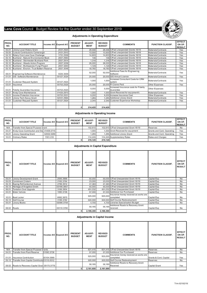
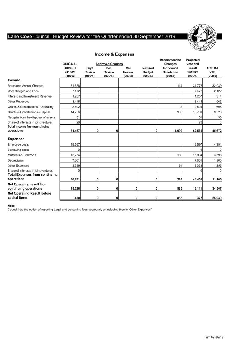
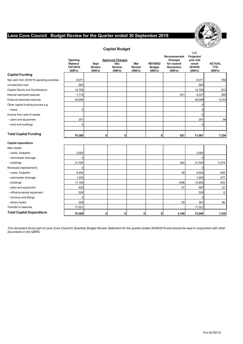
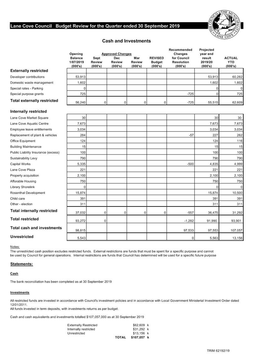
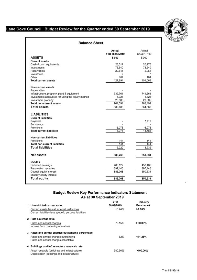
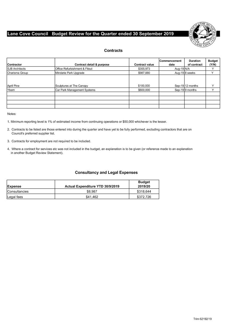
Ordinary Council Meeting 18 November 2019
Lane Cove Council Annual
Report 2018-19
Subject: Lane Cove Council Annual Report 2018-19
Record No: SU245 - 67727/19
Division: Corporate Services
Division
Author(s): Jessica
Quilty
Executive Summary
The Local Government
Act requires all NSW councils to prepare an Annual Report for the previous
financial year by 30 November each year. Lane Cove Council’s Draft Annual
Report for 2018 -19 has been produced and this report recommends that Council adopt
this document as the finalised Annual Report and send a copy to the Minister
for Local Government as required by the Local Government Act.
Discussion
Council’s Draft Annual Report for 2018-19 is attached
electronically as AT-1 and covers all of the matters listed in
the Local Government Act to be addressed, in particular the financial
information included in the Audited Financial Statements and the progress on
achieving the projects and activities listed in the 2018-19 Operational Plan.
In order to maintain consistency amongst Council’s
Corporate Planning documents, the Draft Annual Report is organised into
Council’s Six Strategic Planning Themes in the same way as the Liveable
Lane Cove: 2030 Plan and the annual Operational Plan. This helps to
reflect Council’s achievements across the key themes rather than by
Council’s internal organisational structure.
The Draft Annual Report
contains an introduction by the Mayor and General Manager for this reporting
period. The highlights for 2018-19 as described in their introduction has been
reproduced below for the Councillors and community’s information:-
“From the vision of The Canopy and the new
Mindarie Park through to socially responsible projects such as HarbourCare and
a Dementia-Friendly Lane Cove, we are proud to bring you this snapshot of
Council’s commitment to a Liveable Lane Cove. The first of its kind in
Sydney, the new inclusive playspace at Mindarie Park was opened to the public
in February 2019. The first of three stages within the park, the playspace in
Lane Cove North will soon be complemented by the adjacent open space which is
due to open in mid 2020.
A number of other playgrounds were also
upgraded this past year including Kimberley Avenue and Billy Bryson playground
(at Kingsford Smith Oval). Keen to provide a range of open space for our
community, Kingsford Smith Oval now also includes a new multicourt while
Blackman Park is home to a new off-leash dog park.
Works are now underway on the new outdoor
pool and grandstand at Lane Cove Aquatic Centre. The 50 metre pool closed in
December 2018 after an impressive 57 years of service. Plans for the new eight
lane pool (one additional lane) and improved Grandstand complete with pool deck
level amenities were finalised before construction started in June.
Around the corner in Rosenthal Avenue,
construction continues on The Canopy Lane Cove. It has been an extremely busy
year on and off-site as we put essential infrastructure in place ahead of a mid
2020 opening.
It
won’t be long until the local community and businesses can take advantage
of the full 500 car parking spaces and the new village green surrounded by
exciting new restaurants. During this time we have been working with existing
businesses to provide access to free business advice via the popular Small
Business Breakfast series as well as a free Plastic Straw
Reduction
program. As part of our ongoing commitment to address the issue of plastic
waste, Council launched a new program called HarbourCare. A range of events
were also held in July as part of the Plastic Free July campaign while an
innovative Guiding Stars public art project shone a spotlight on the issue of
electronic waste at Christmas. The largest ever Council-run event was held in
November with Food and Wine by the River attracting over 5,000 people to
Tambourine Bay Reserve as part of Festival by the River. New community events
were also introduced throughout the year including a Spooky Spectacular series
in the Plaza and the first ever
Toy Swaps at
Lane Cove Library. Our focus on improving customer service is well underway
with a Customer Journey Mapping program highlighting a number of opportunities
to help simplify interactions with our residents. The first improvement rolled
out was the introduction of online bookings for Council facilities. We have
also provided additional opportunities for the community to connect with
Council news and information via a Council-run Facebook page introduced early
in 2019”.
Conclusion
The Draft Annual Report
has been prepared to meet the requirements of the Local Government
Act. Upon adoption of the Report, a copy will be forwarded to the
Minister as required by the Act and will be publicly accessible via the Popular
Documents section on Council’s website www.lanecove.nsw.gov.au.
|
RECOMMENDATION
That:-
1. Council adopt the Draft Annual Report
at AT-1 for 2018 -19;
2. The adopted Annual Report be
forwarded to the Minister for Local Government; and
3. The Annual Report be published on Council’s website.
|
Jessica Quilty
Acting Executive Manager
Corporate Services Division
ATTACHMENTS:
|
AT‑1View
|
Draft Annual Report 2018 2019
|
174 Pages
|
|
|
ATTACHMENT 1
|
Draft Annual Report 2018 2019
|
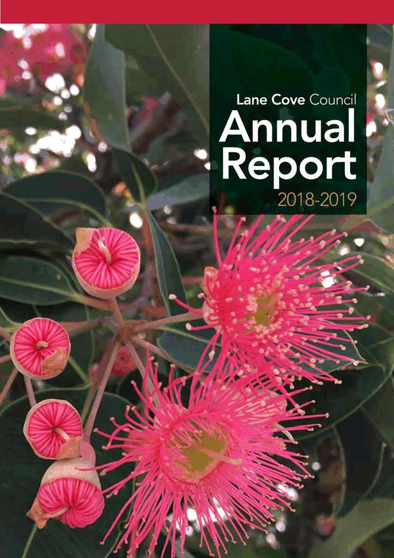


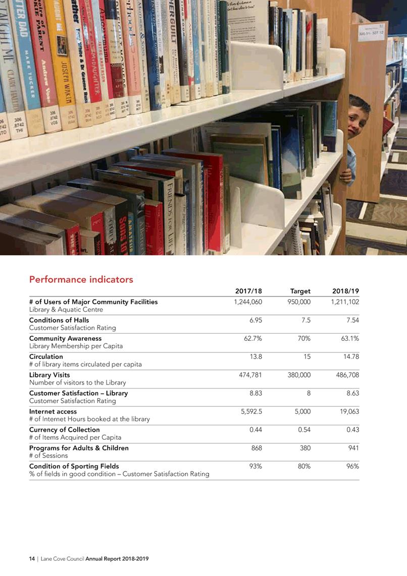
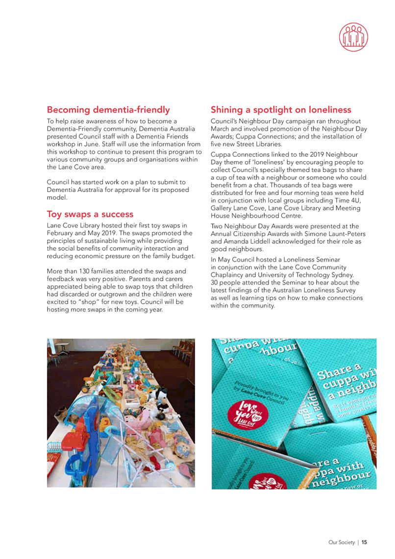
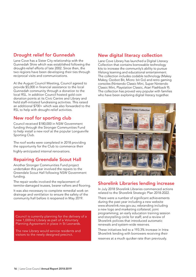
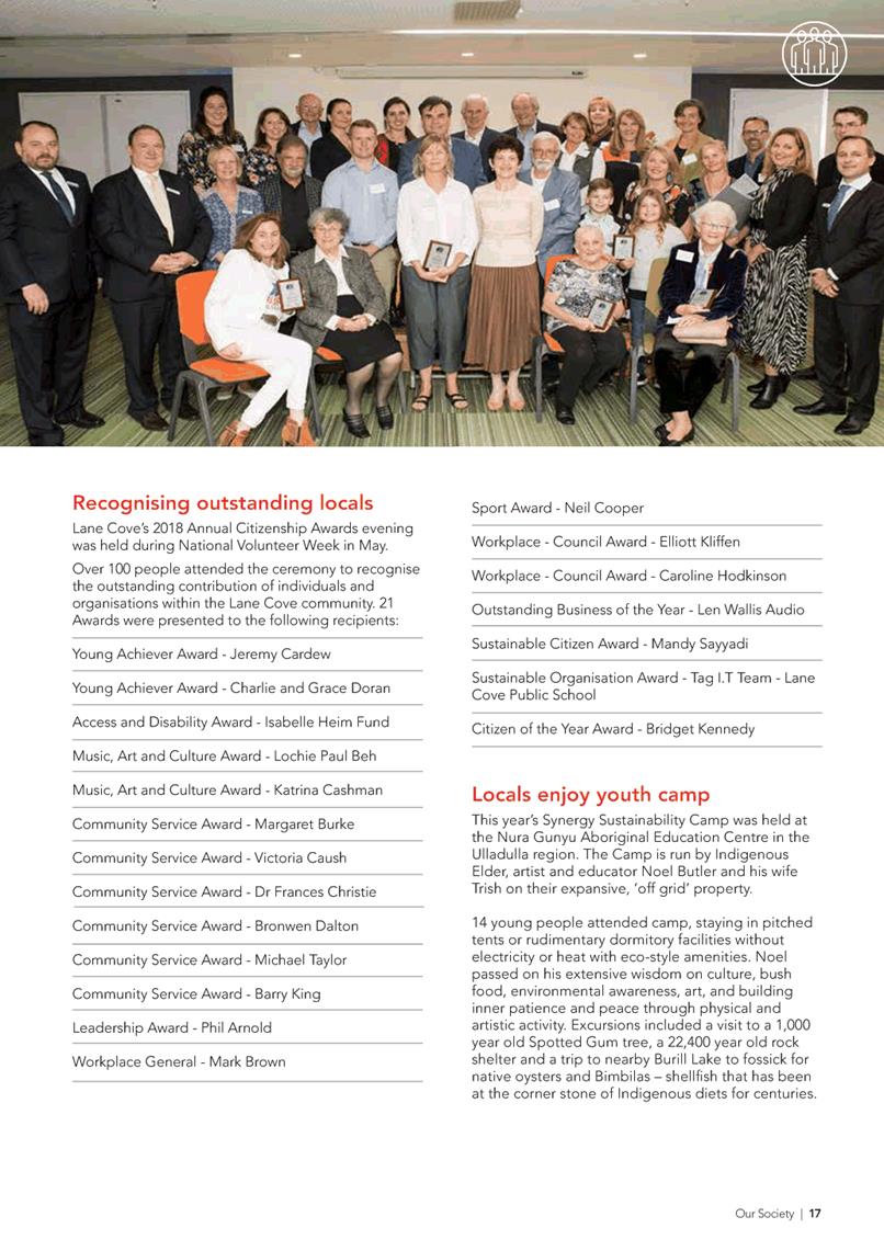

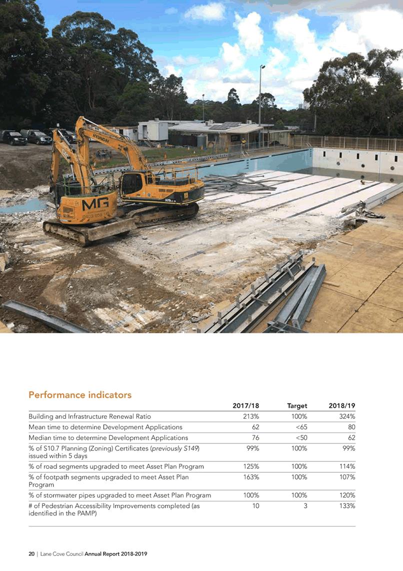
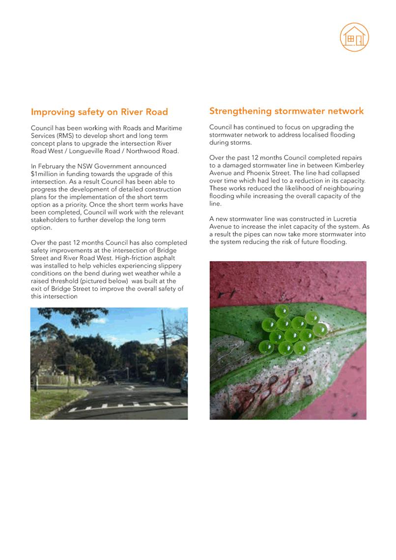
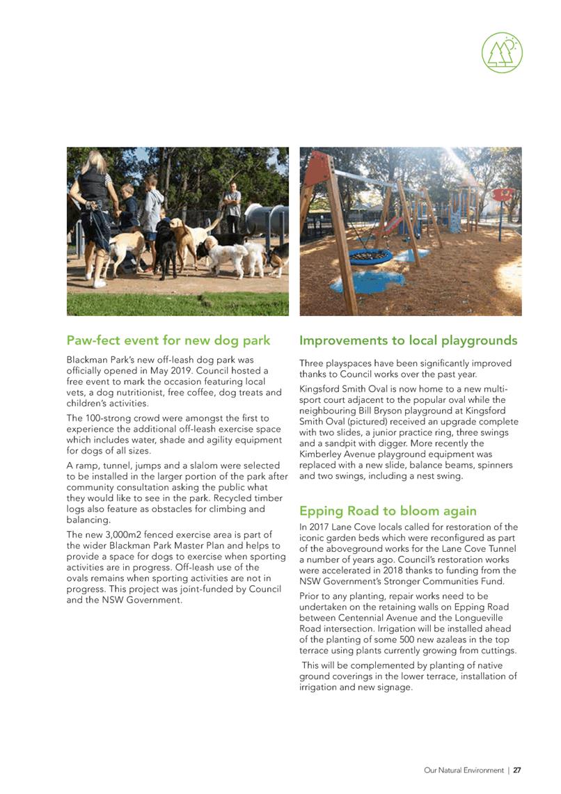
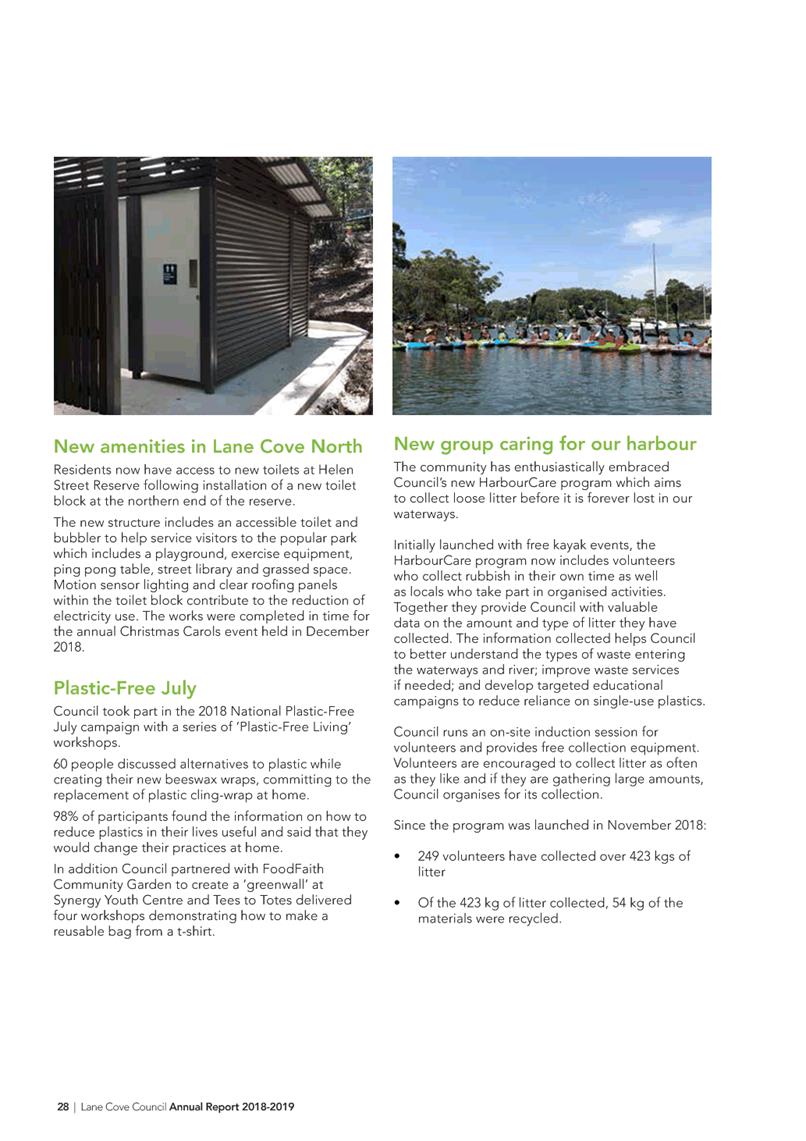
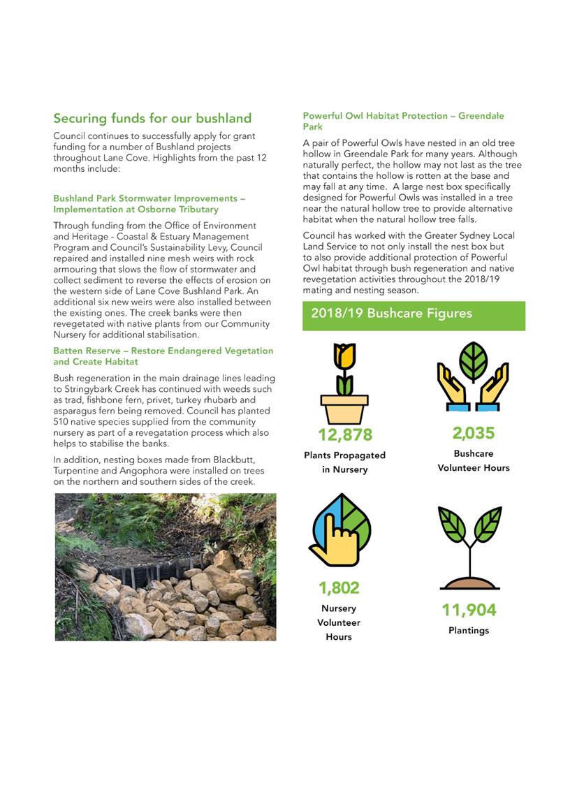


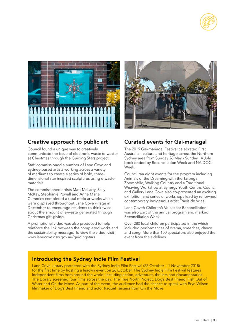
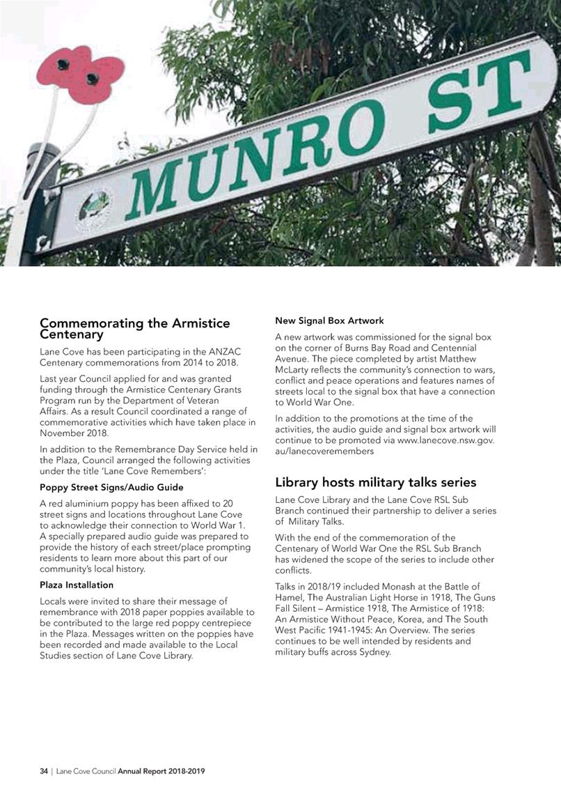
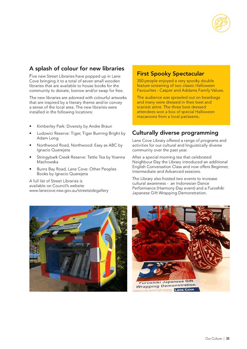

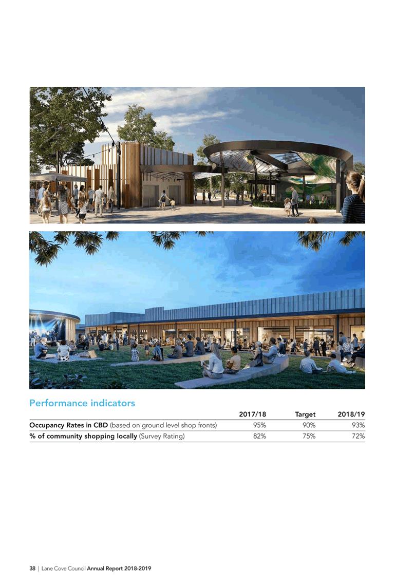
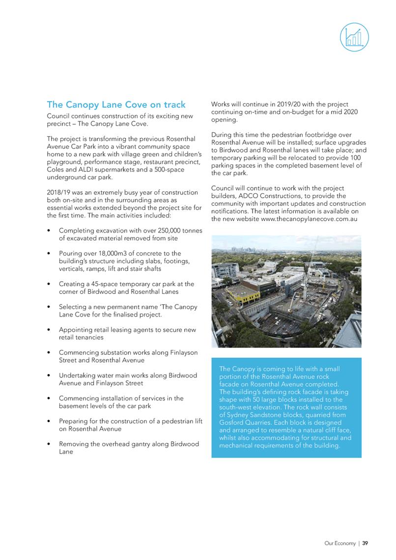

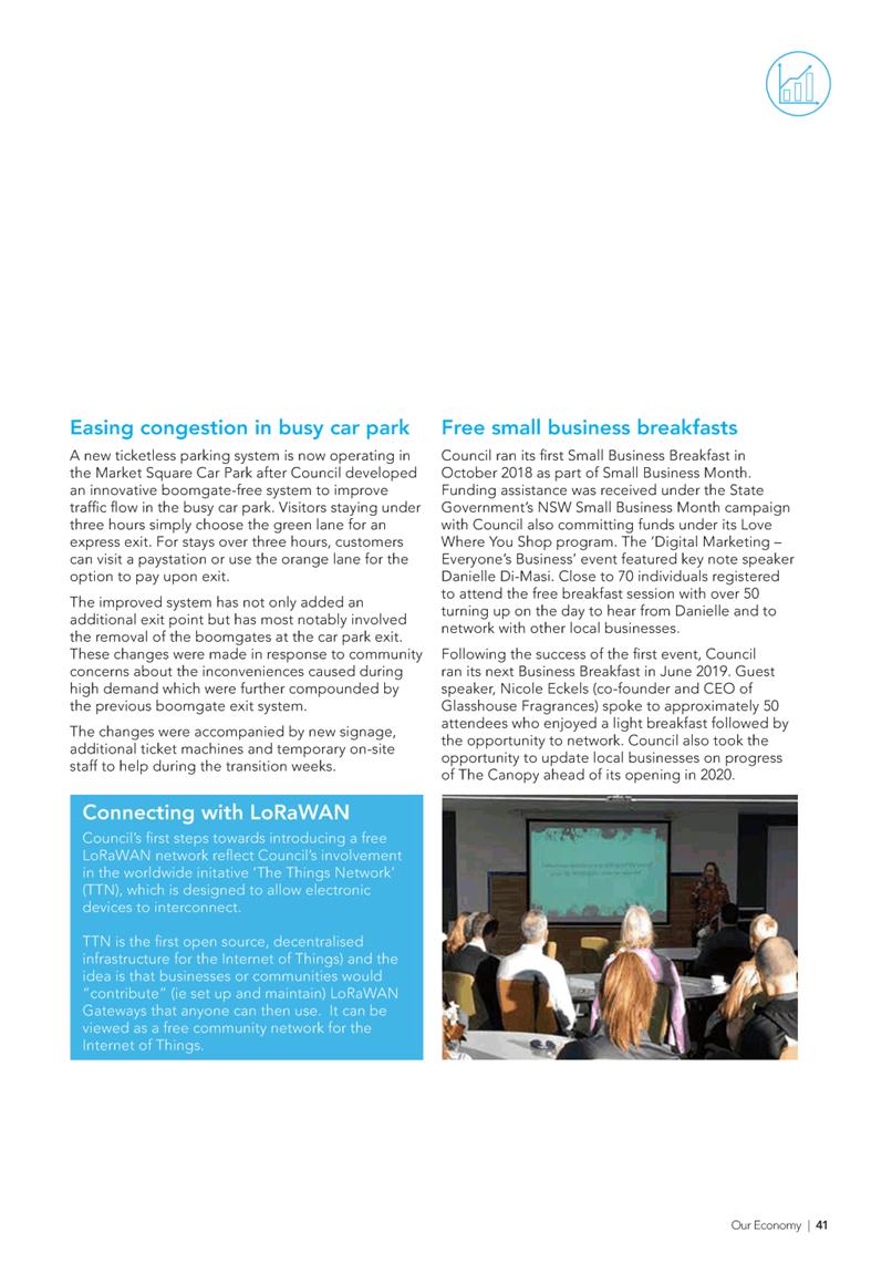

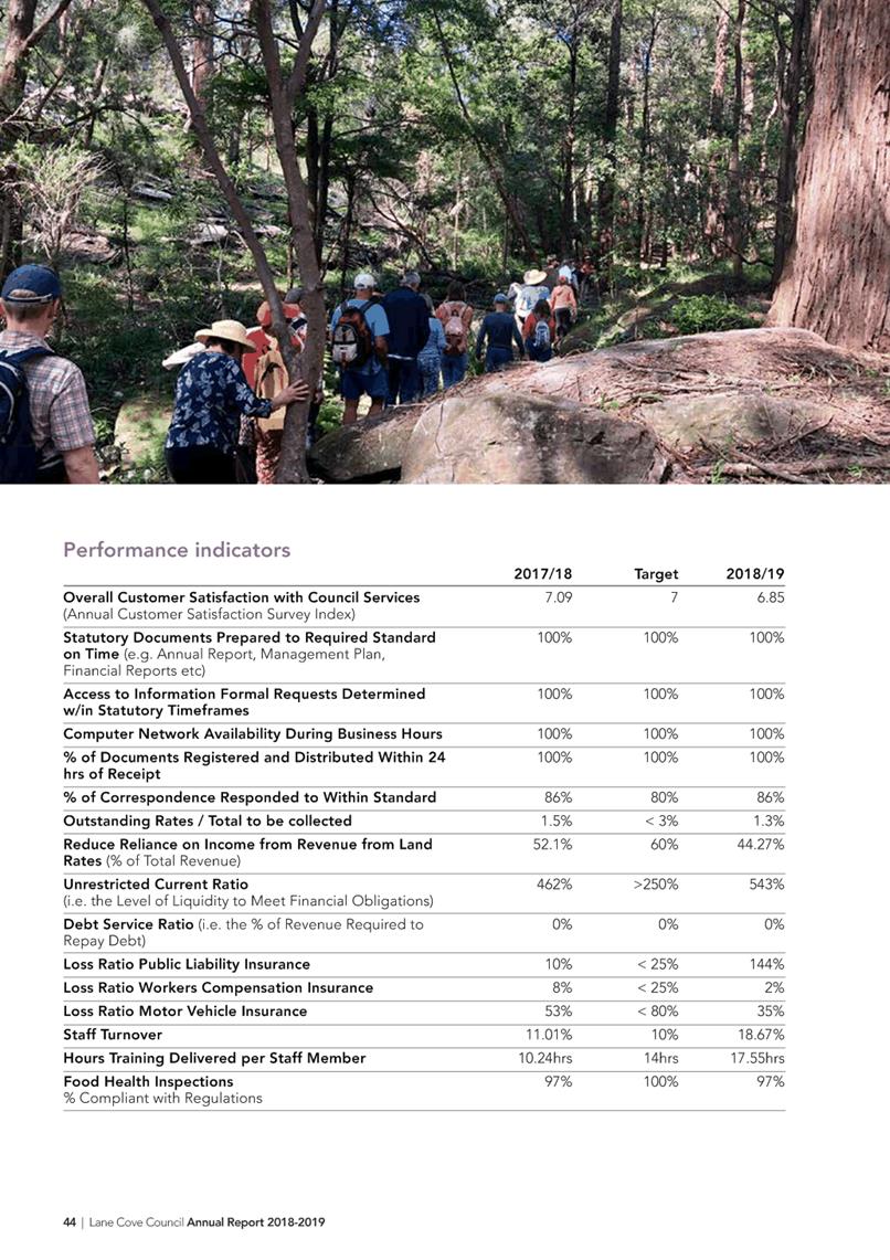
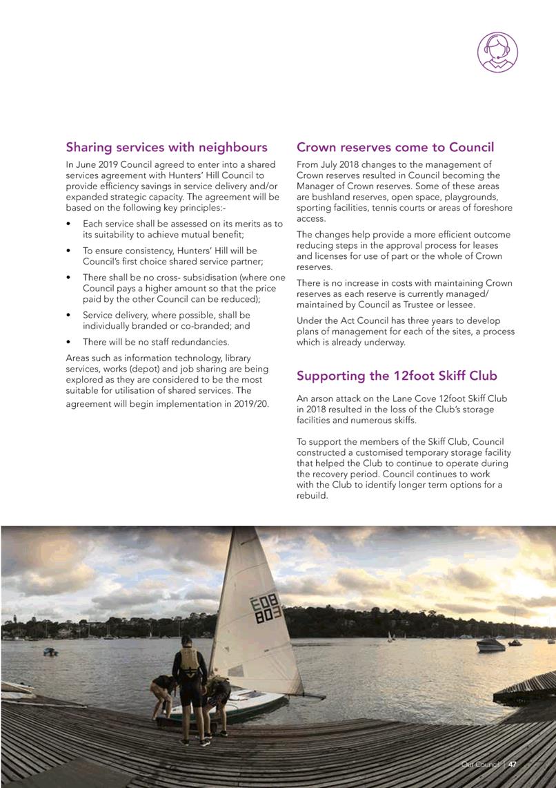


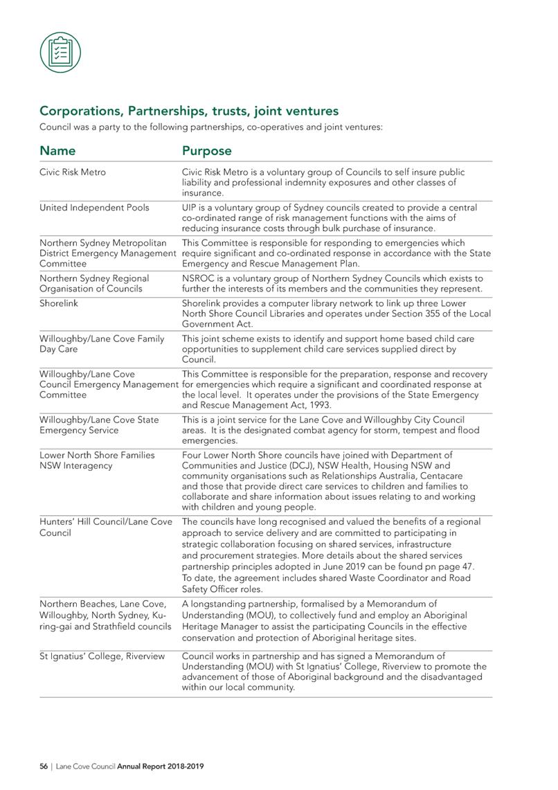
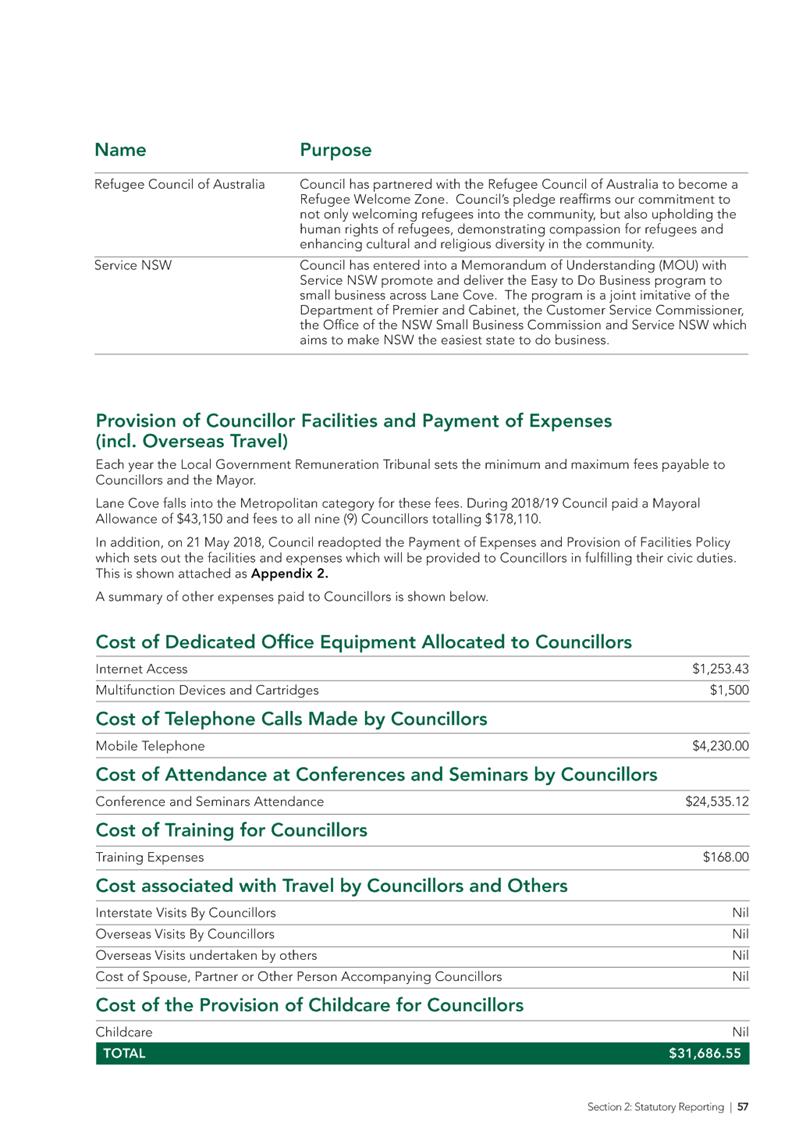
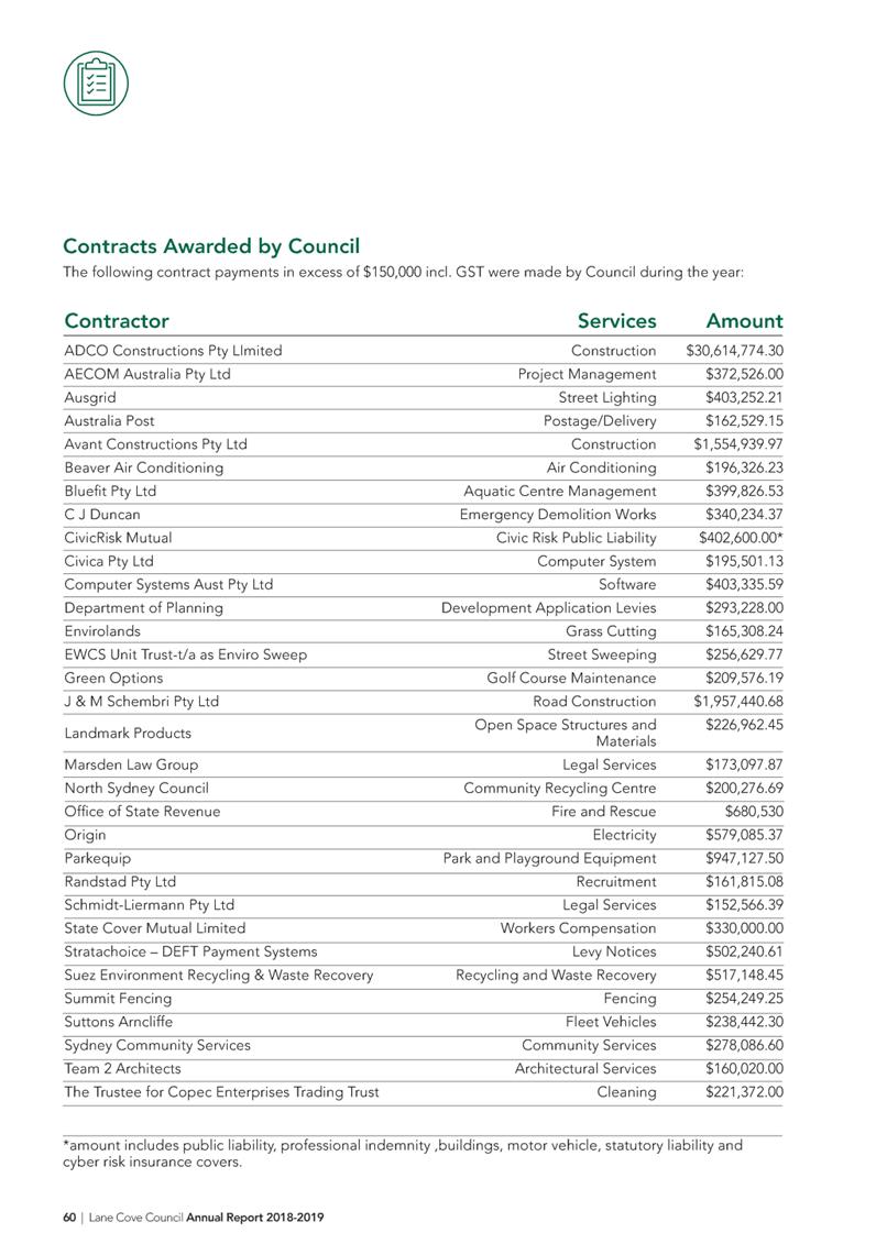
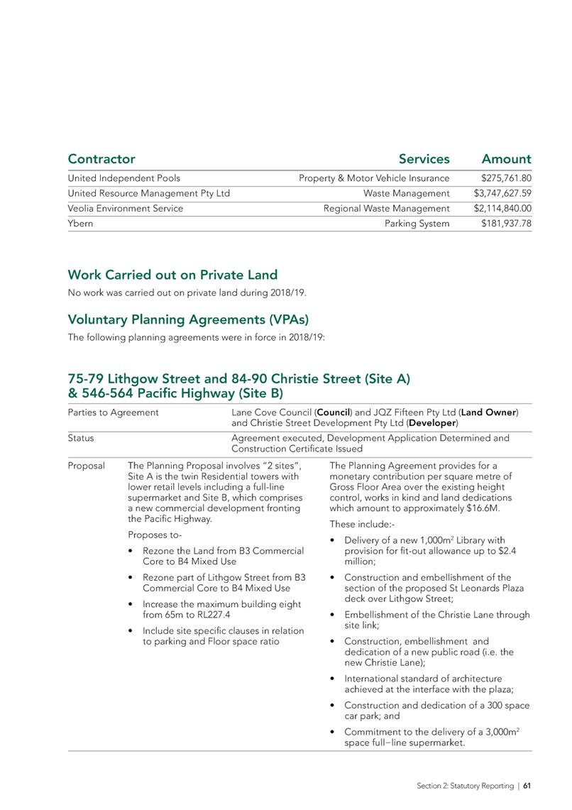
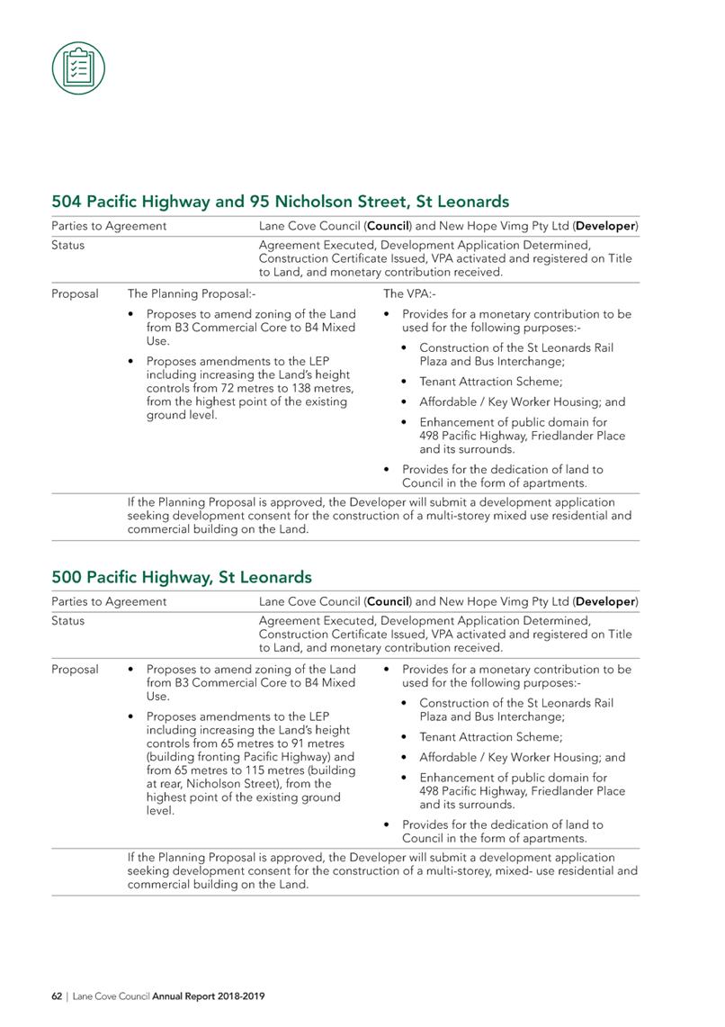
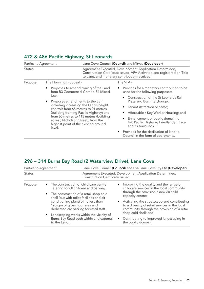
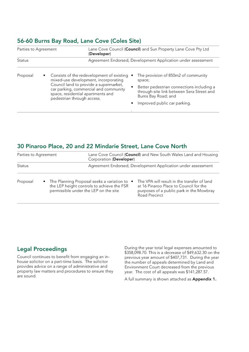

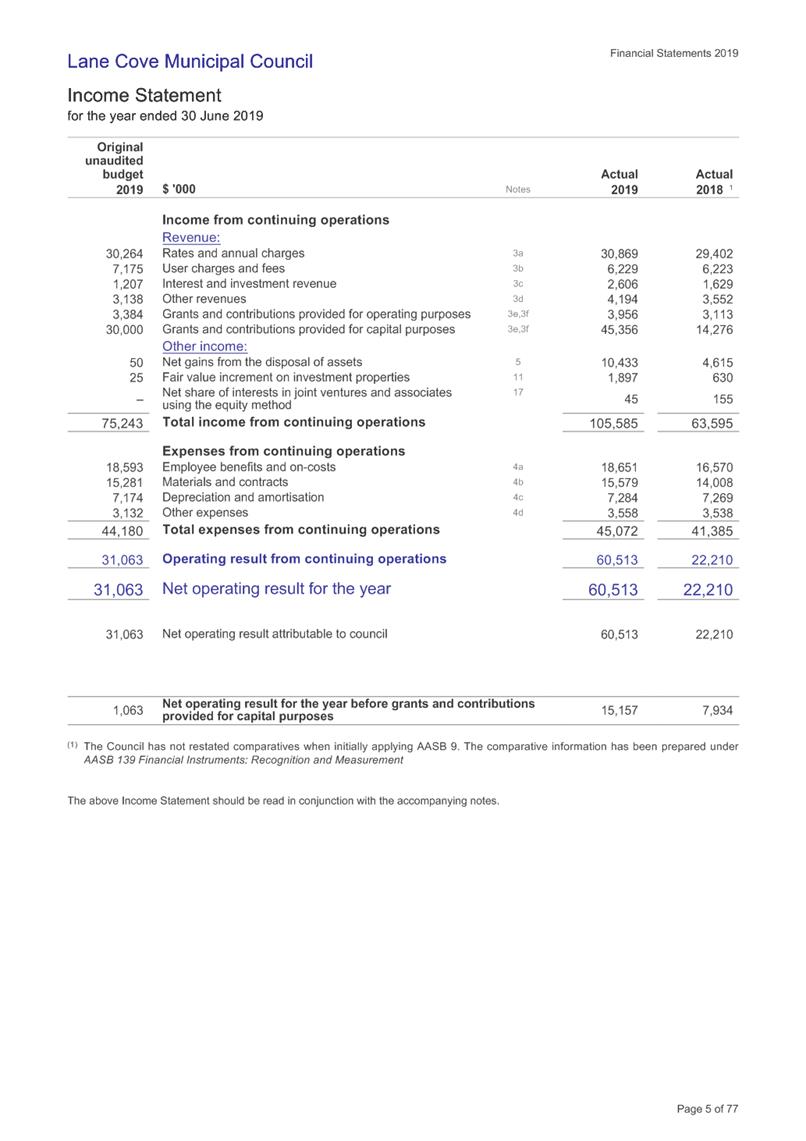
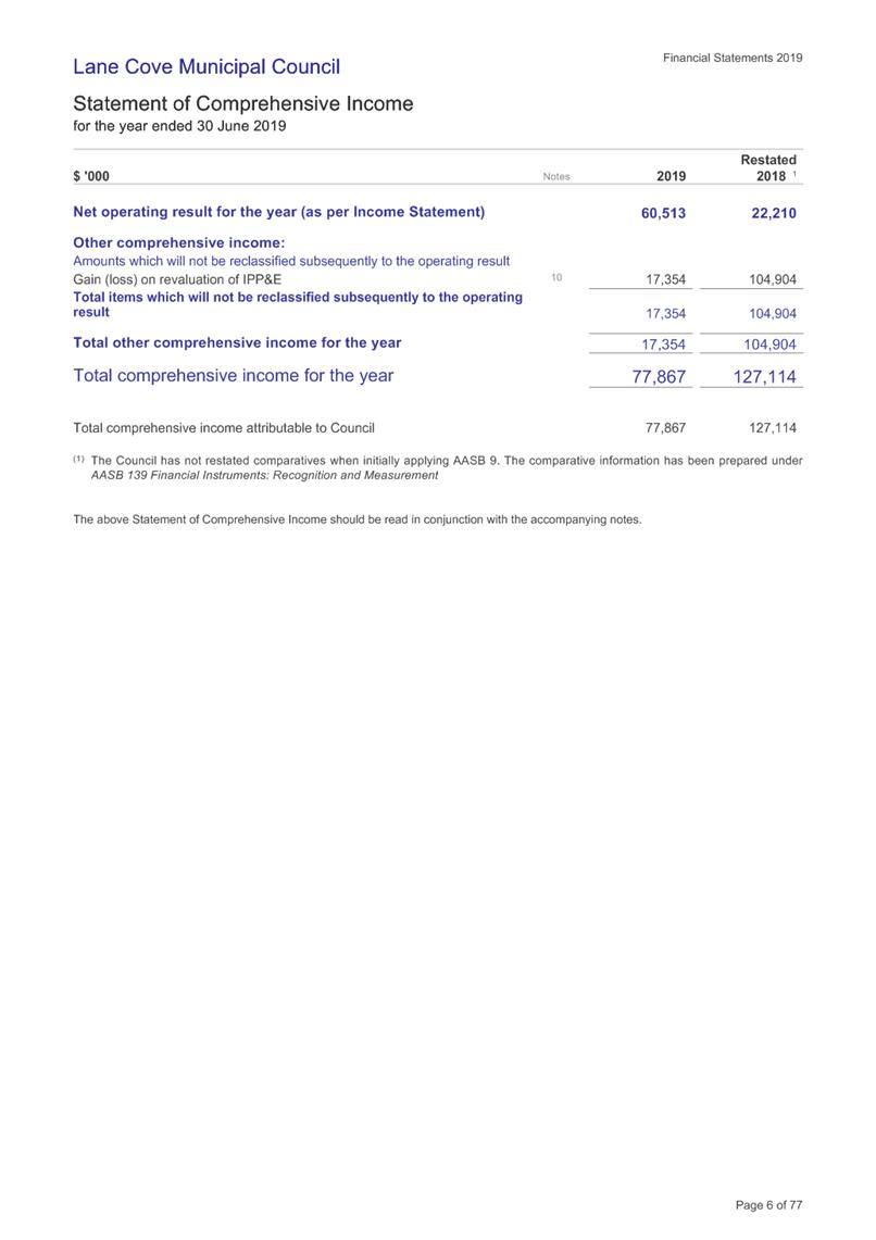
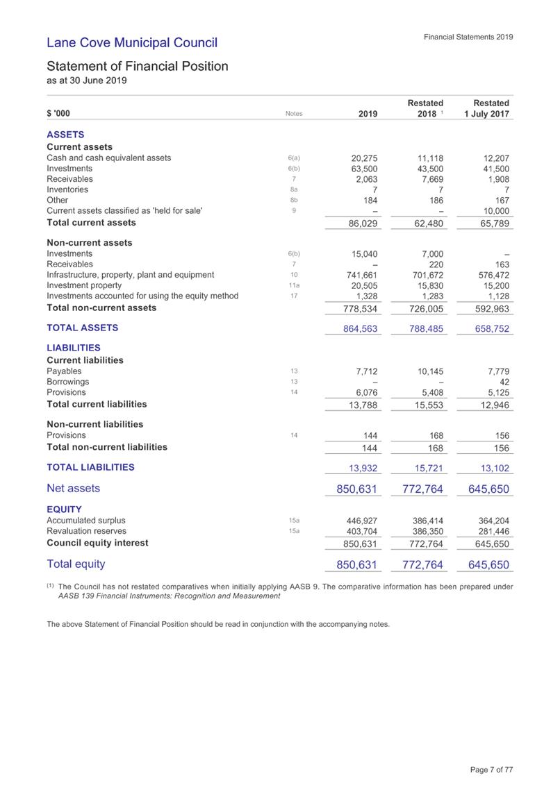
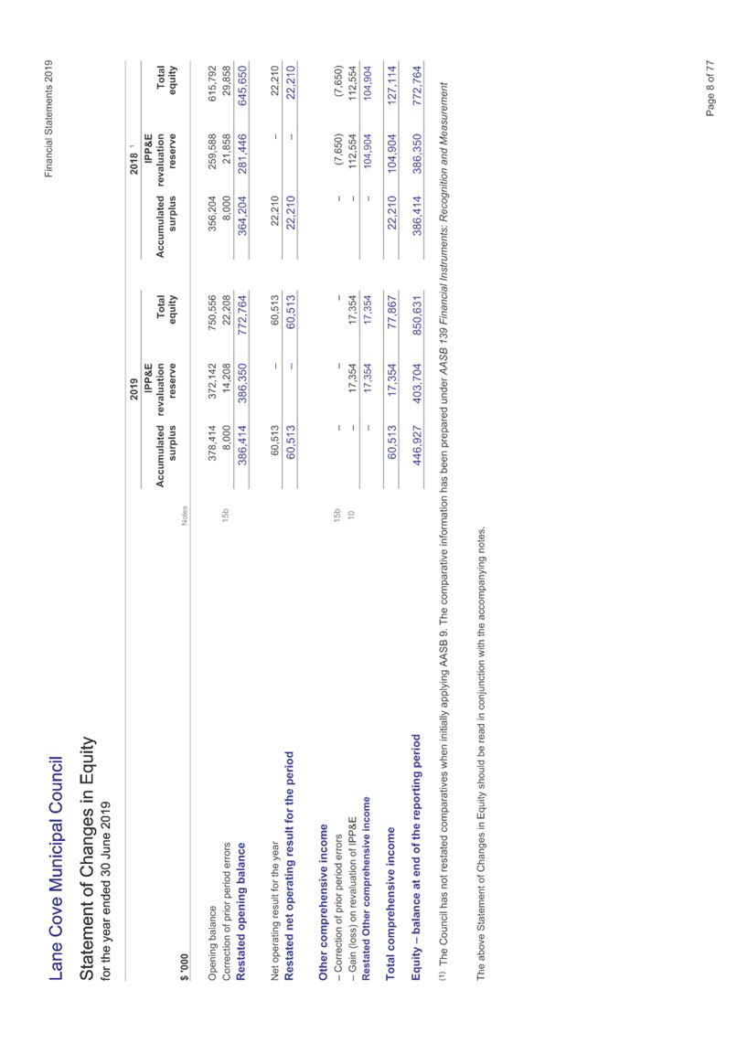
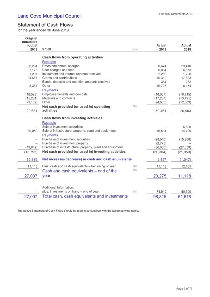
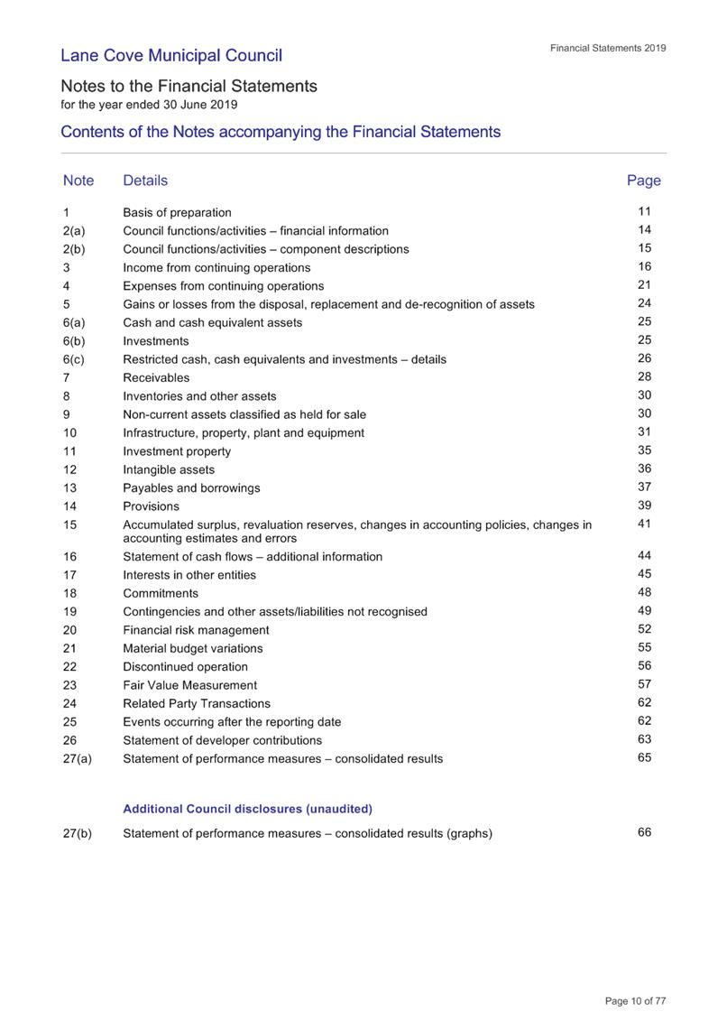
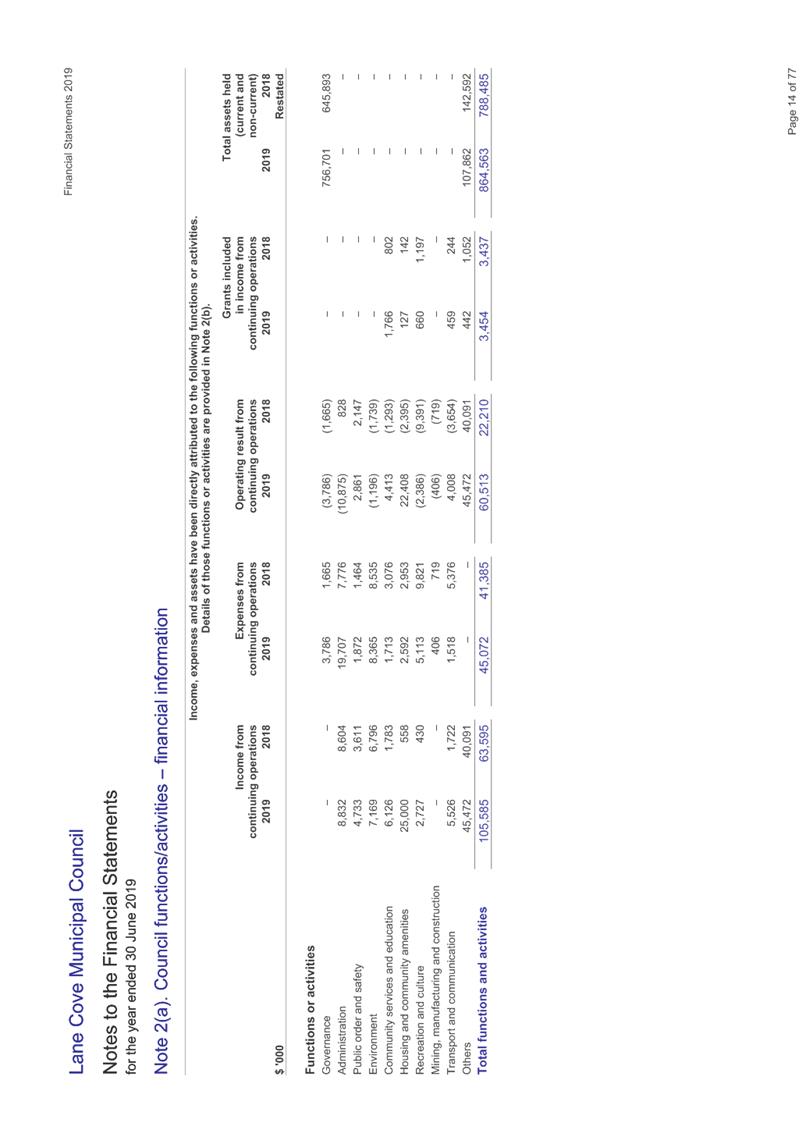
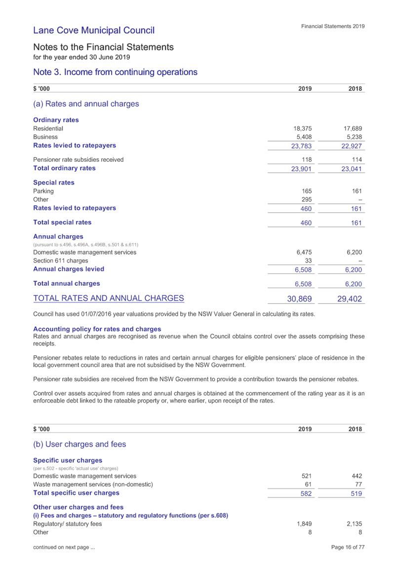
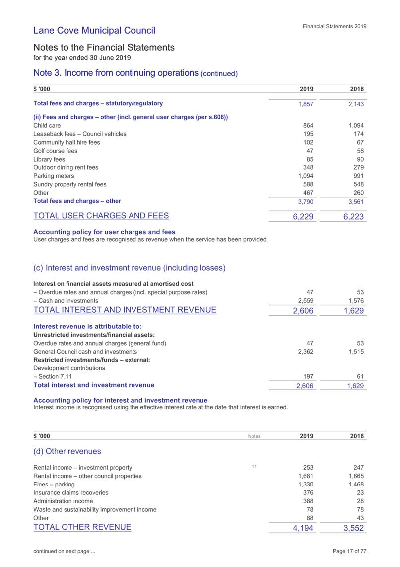
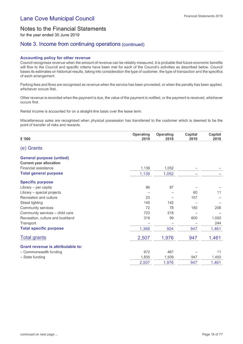
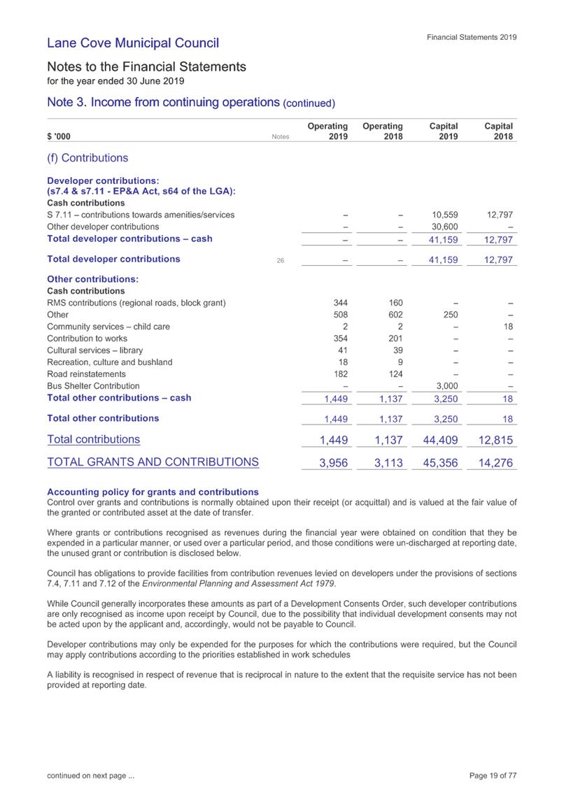
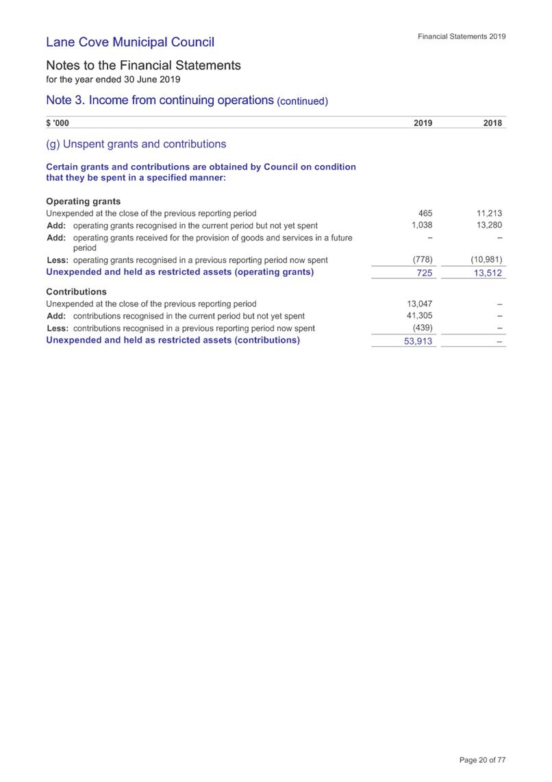
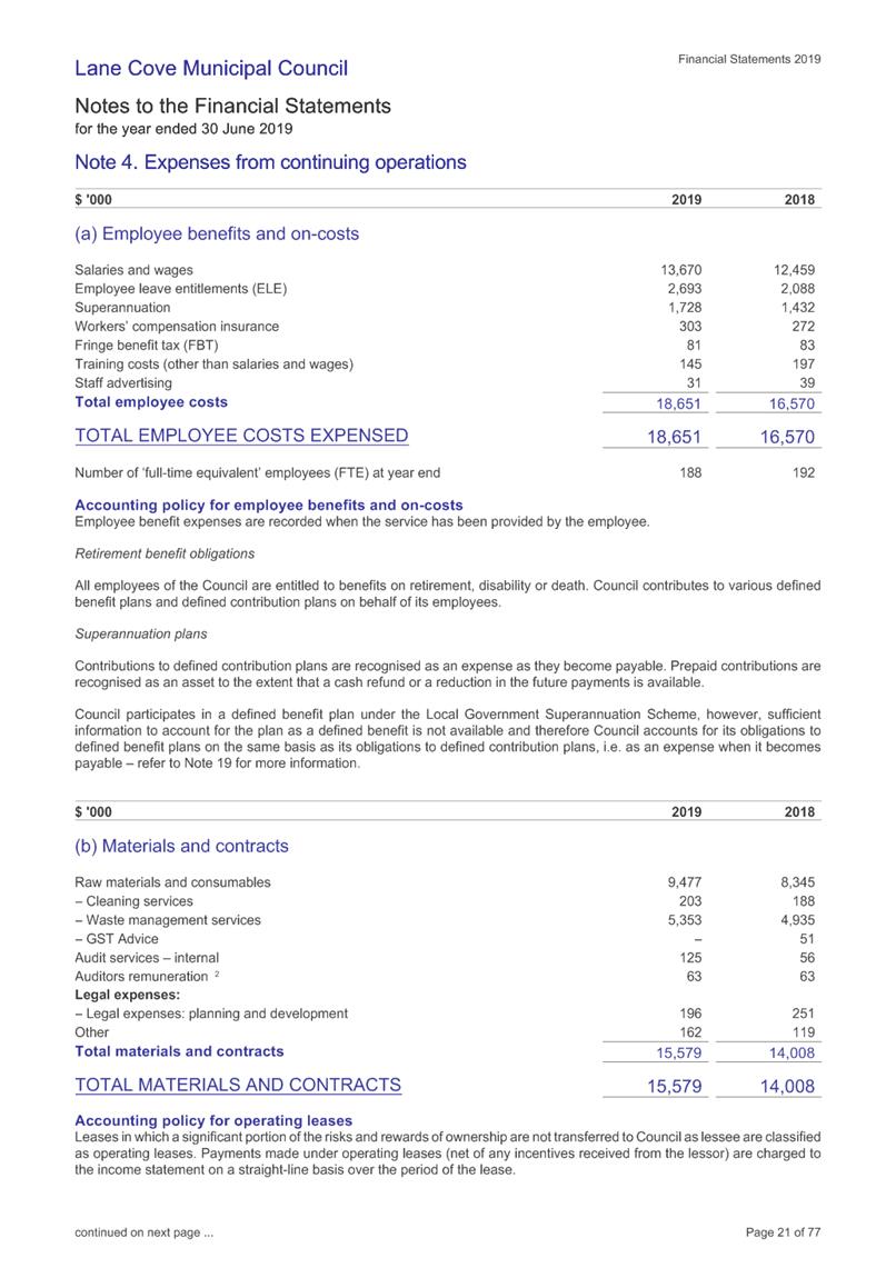
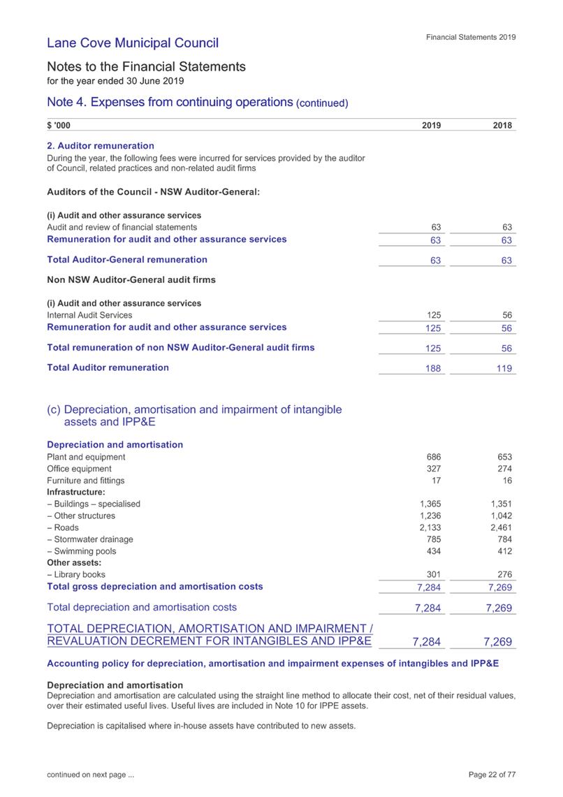


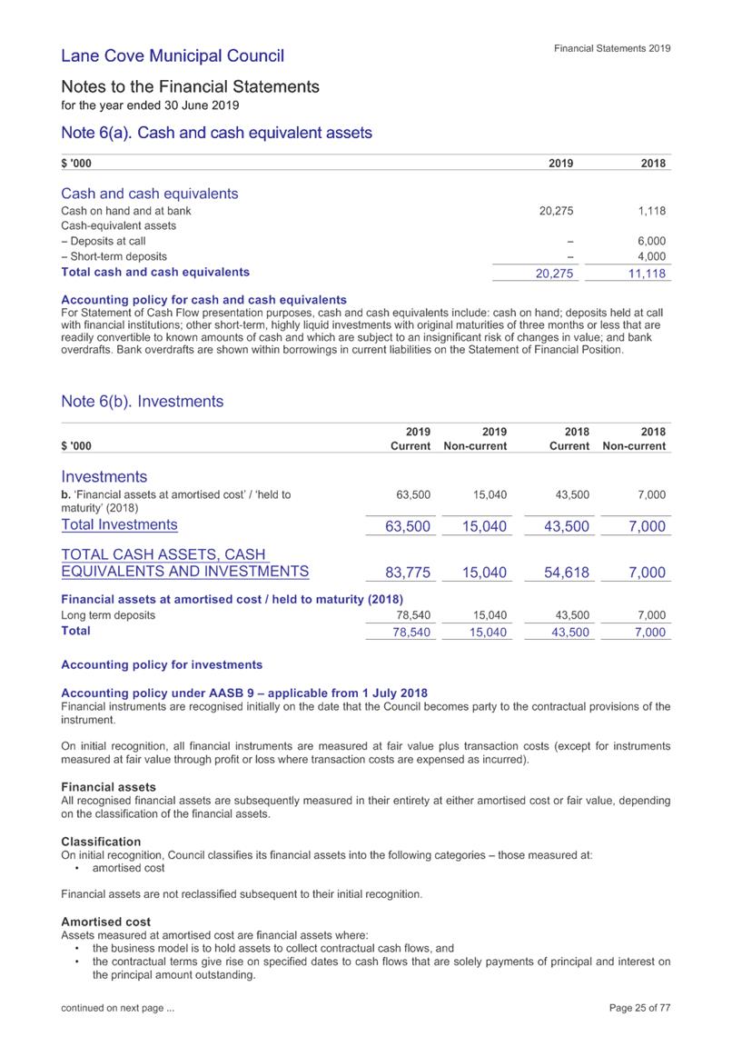

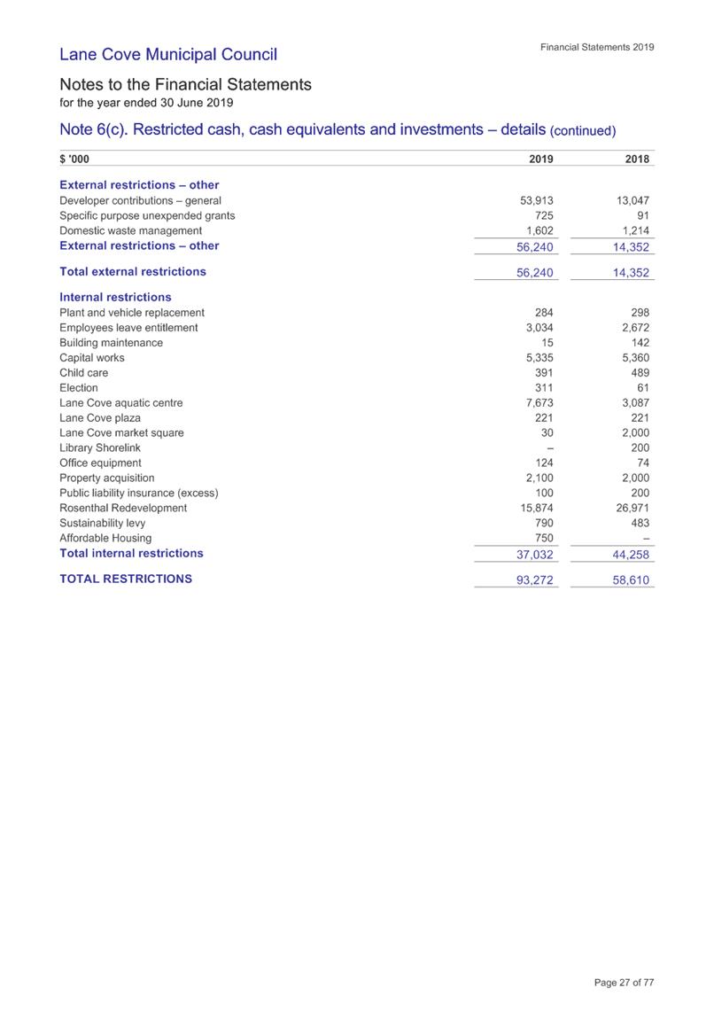
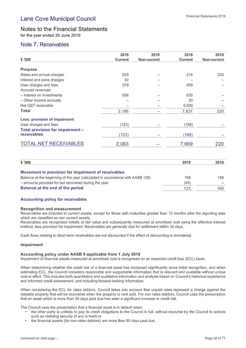
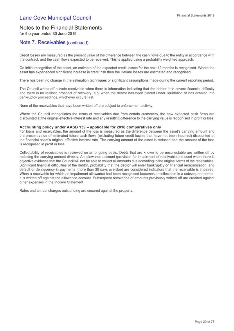
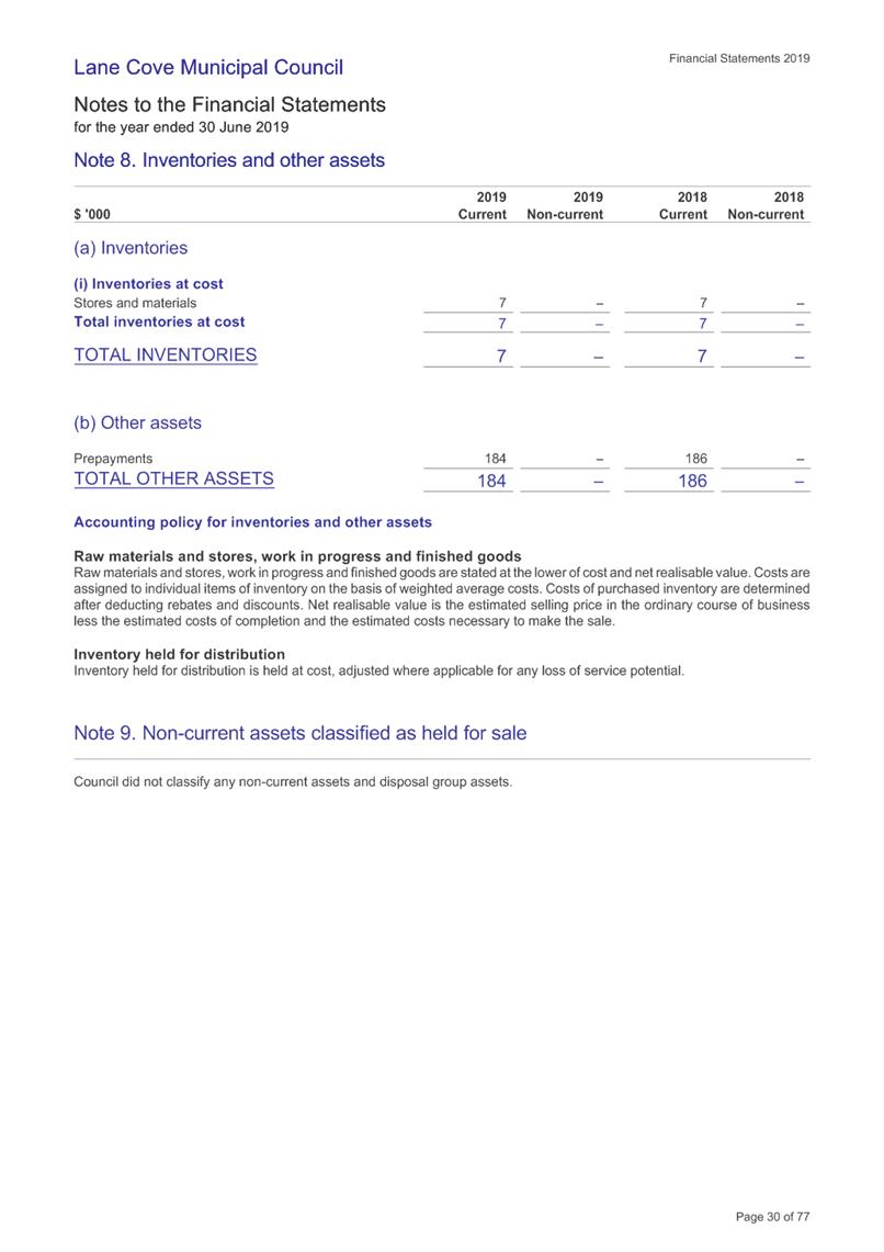
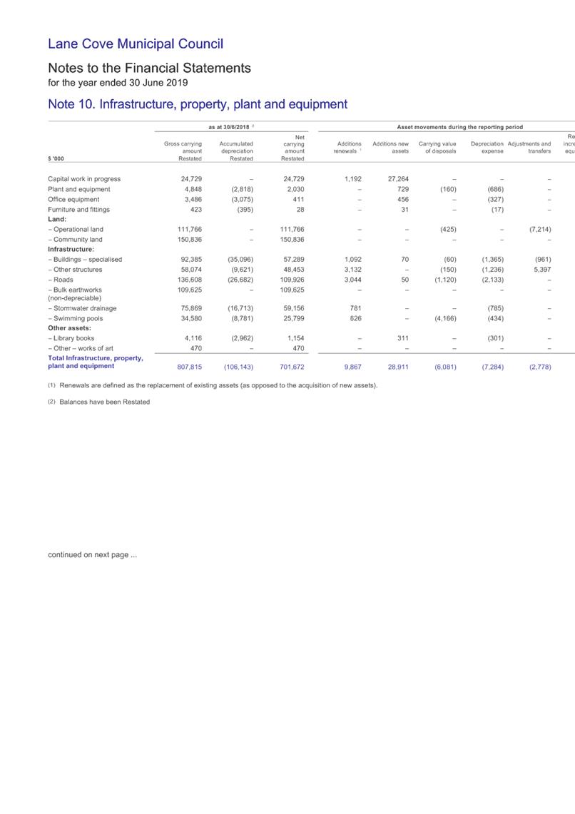


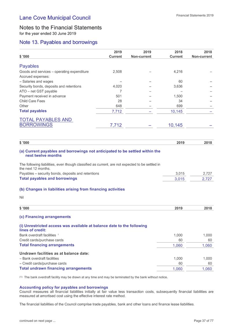


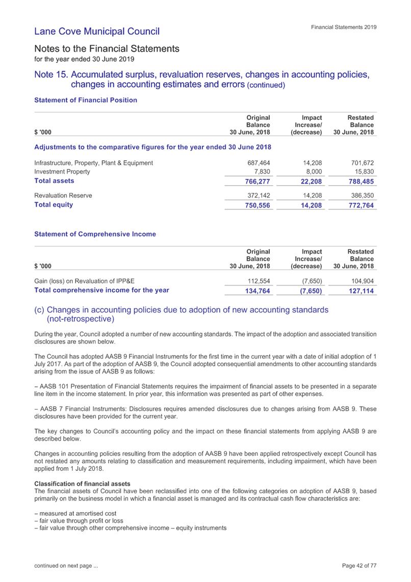


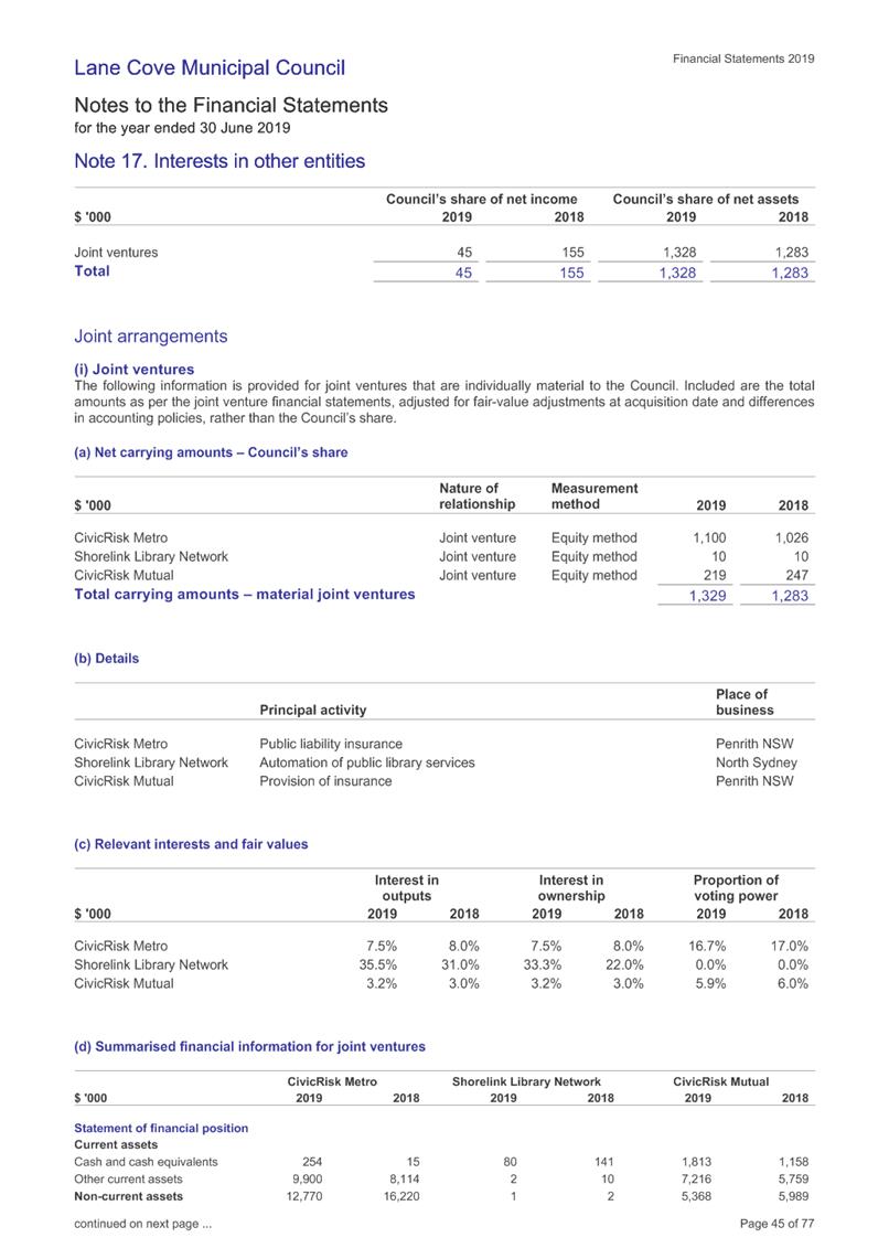
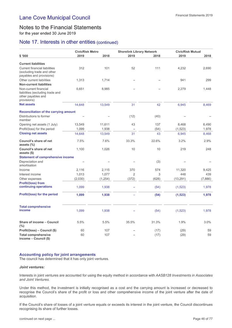

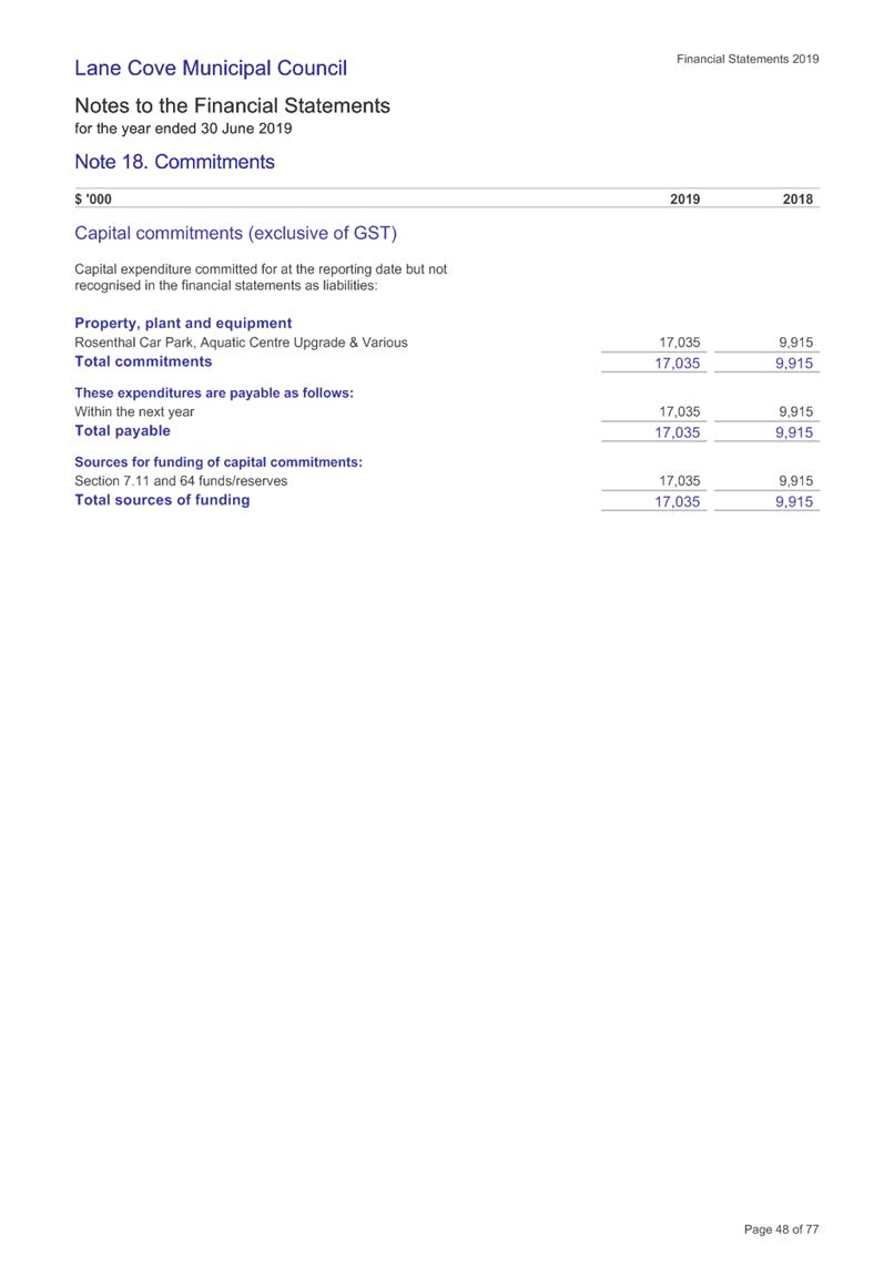
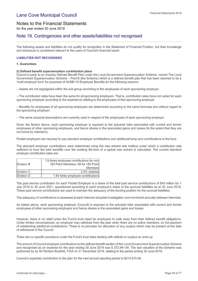
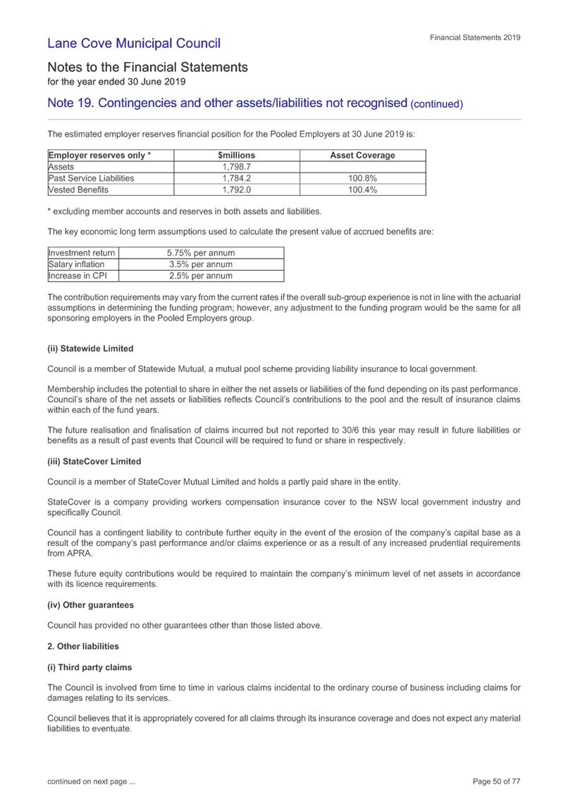
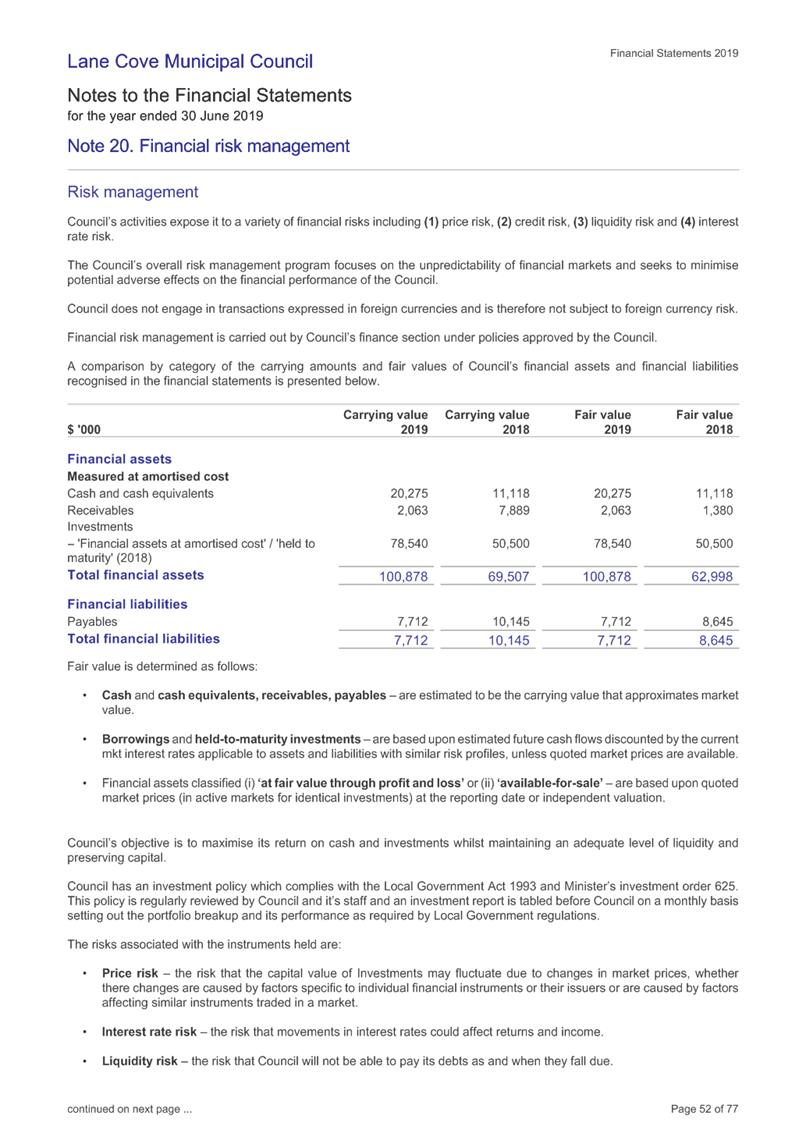

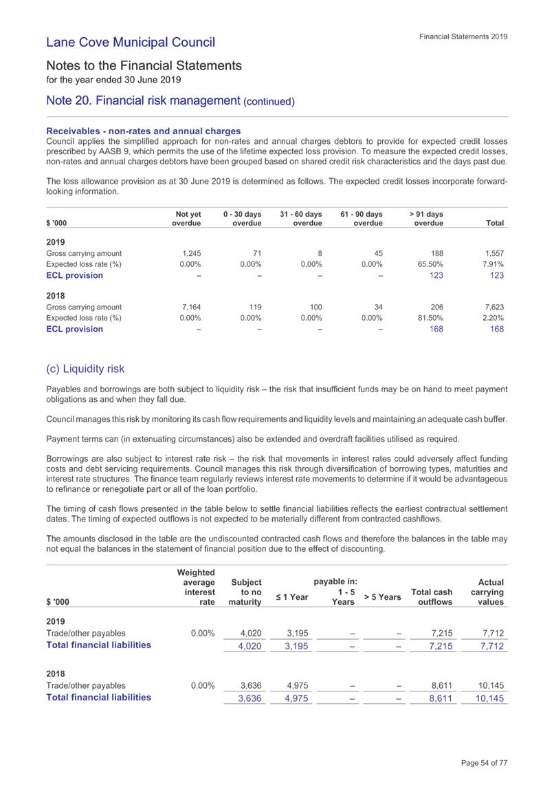
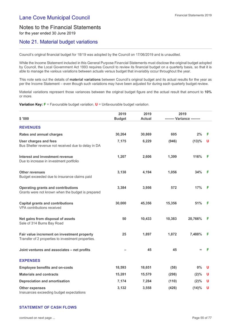
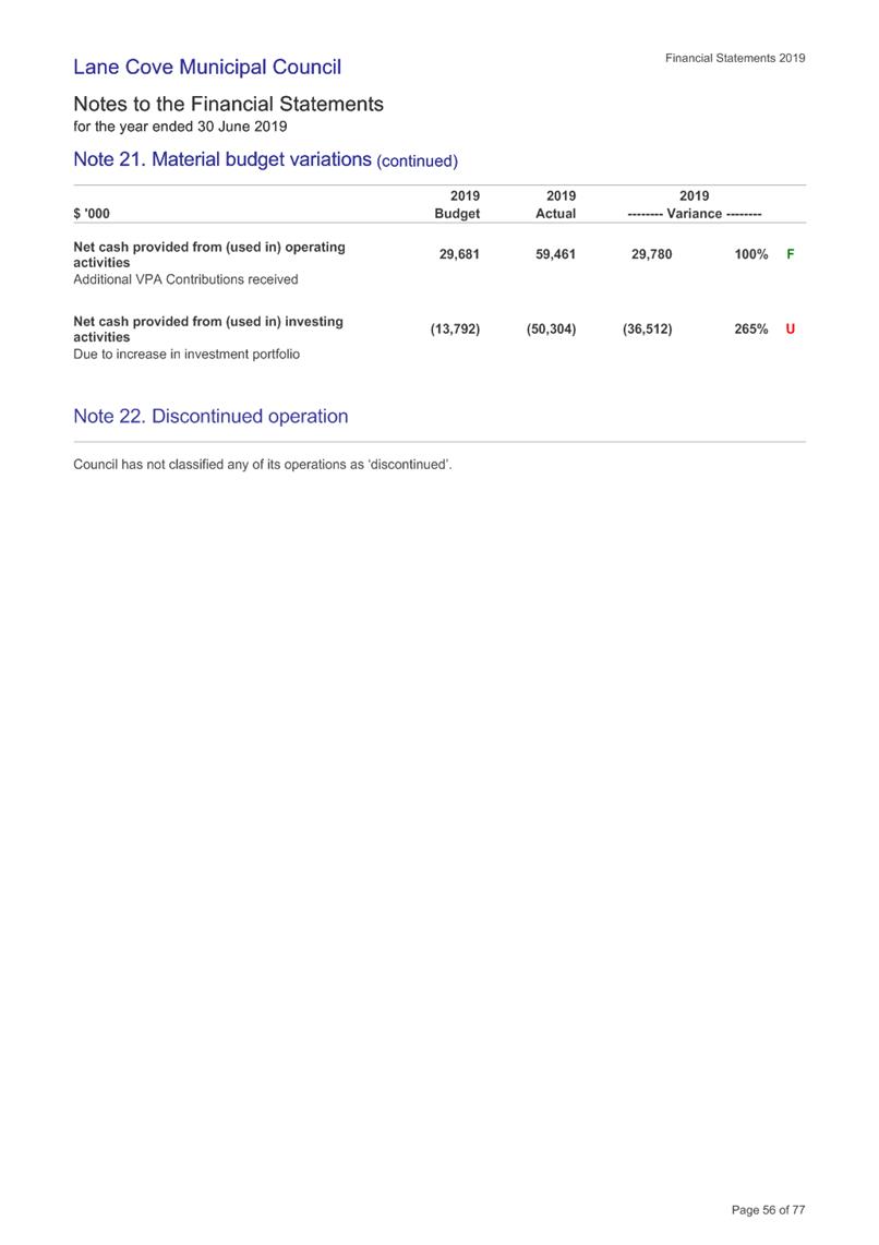
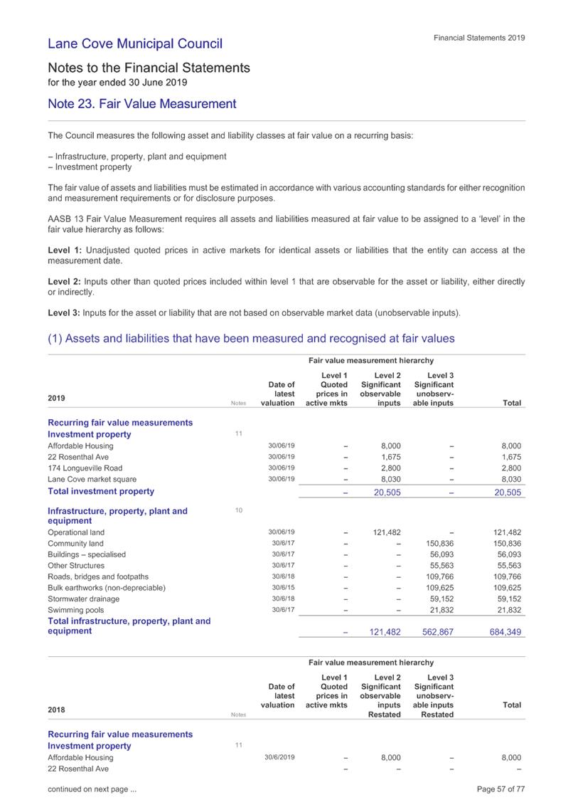
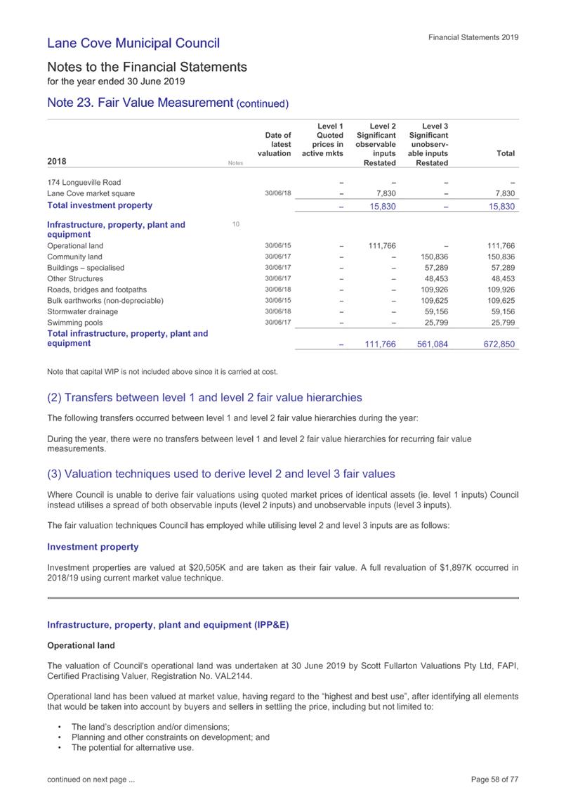


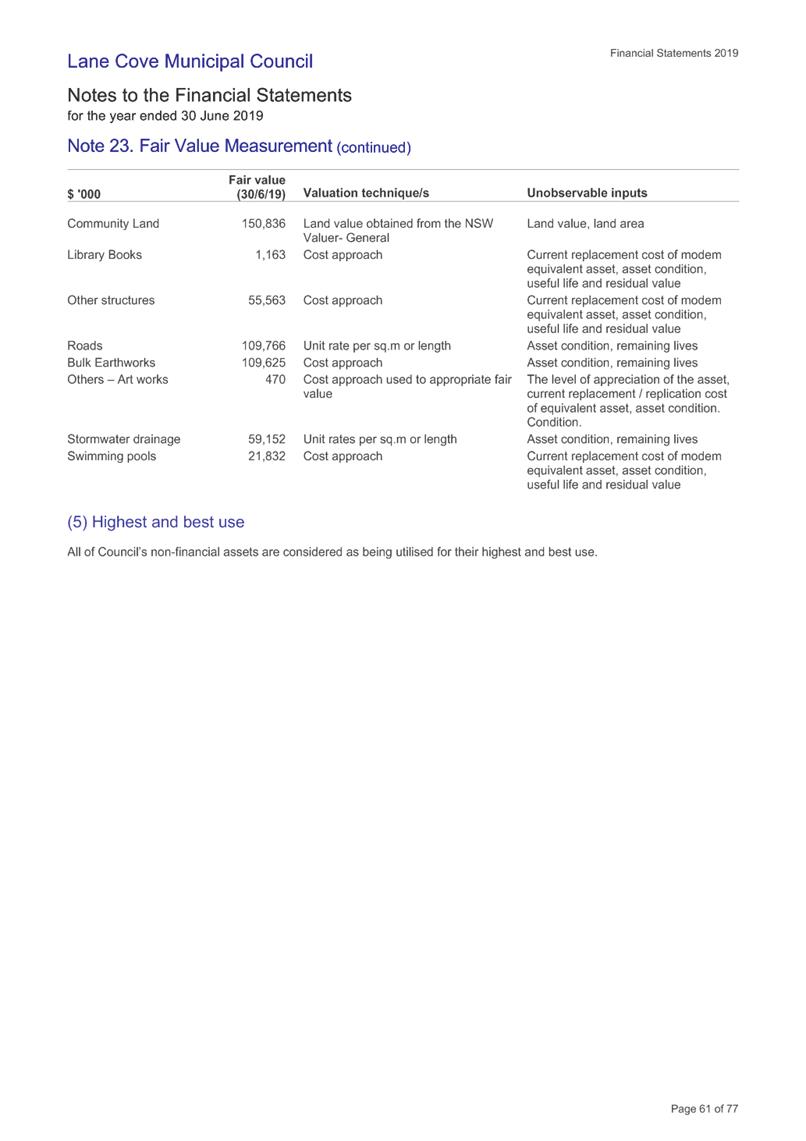
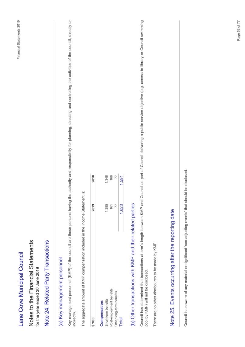
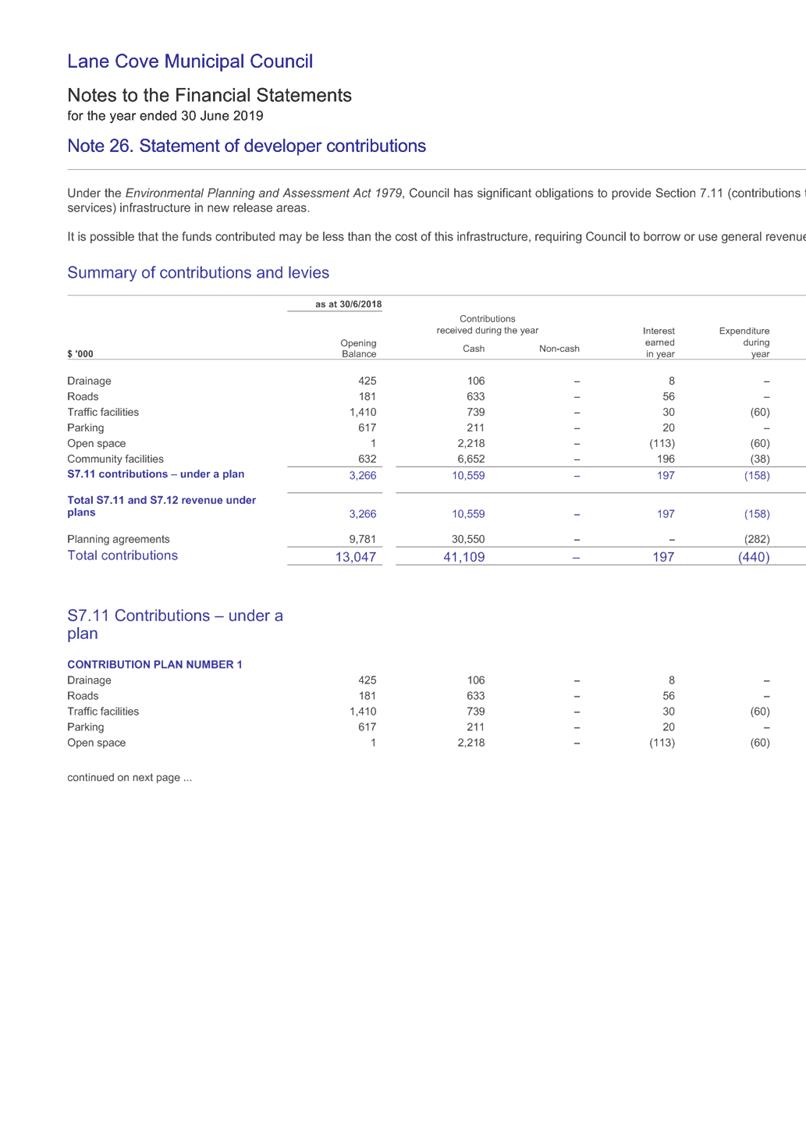
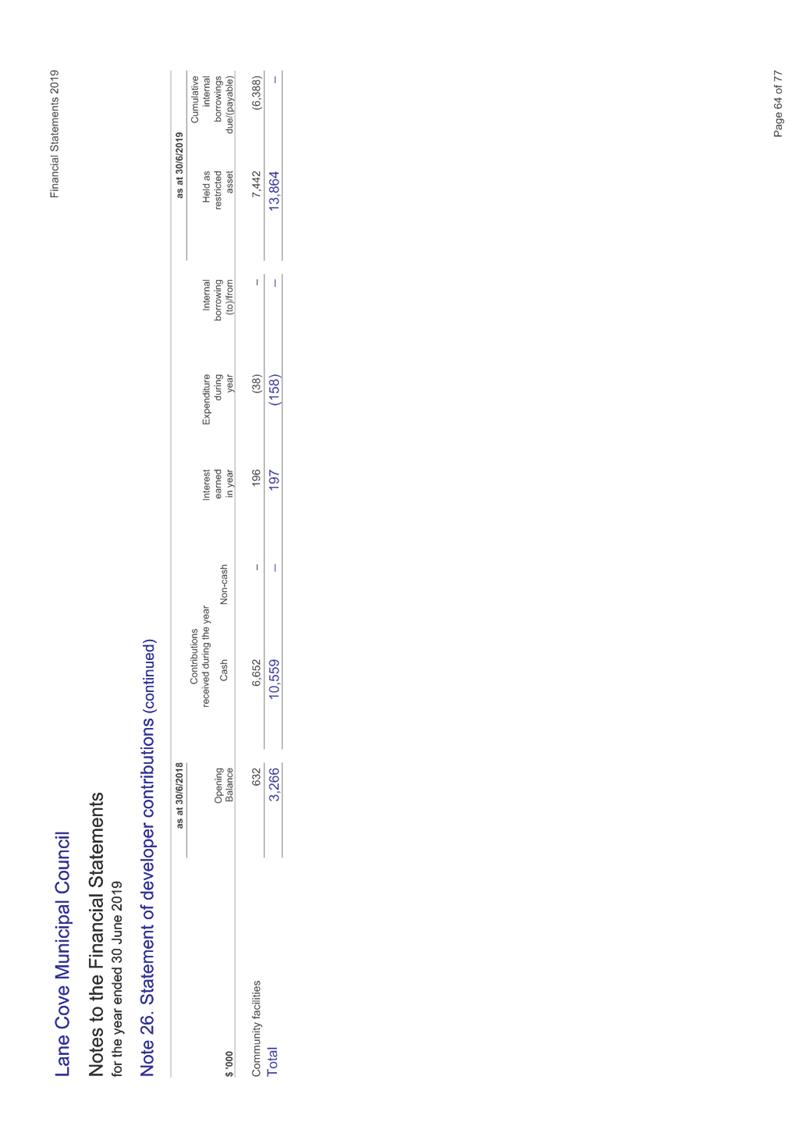
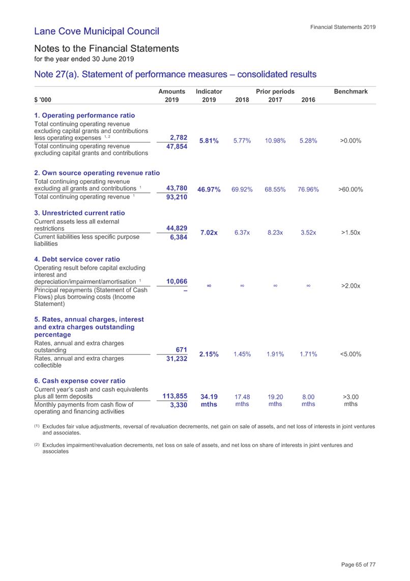
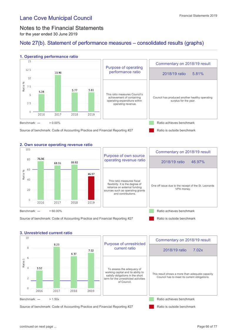
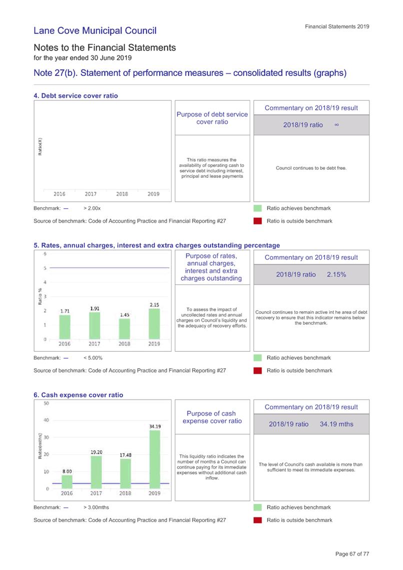

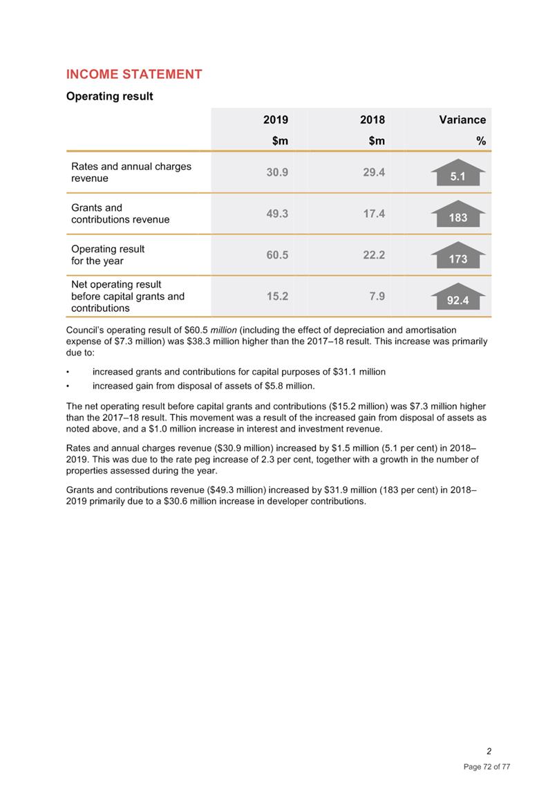
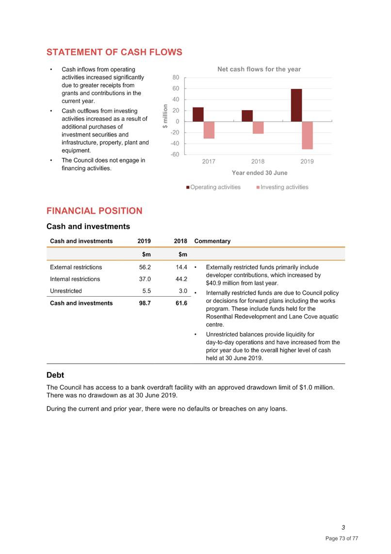
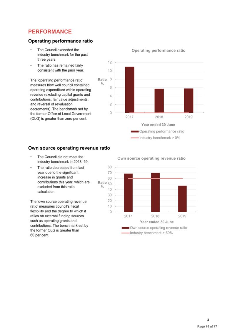

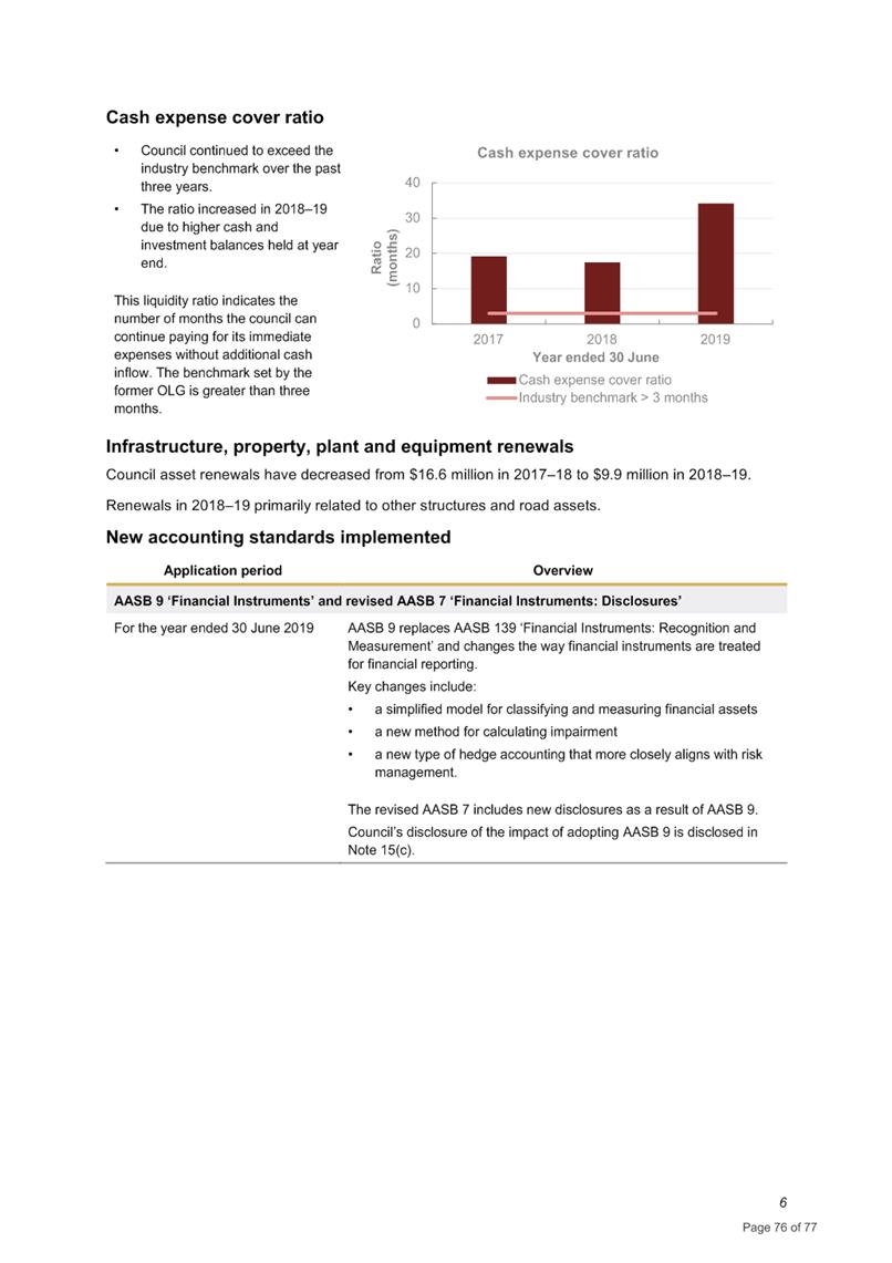


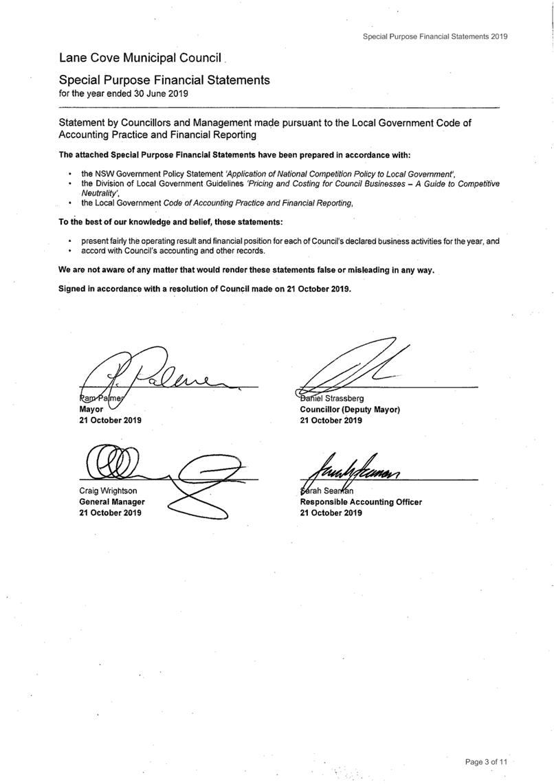
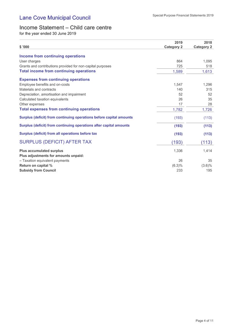
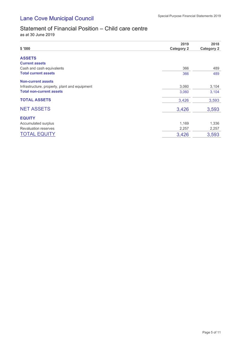


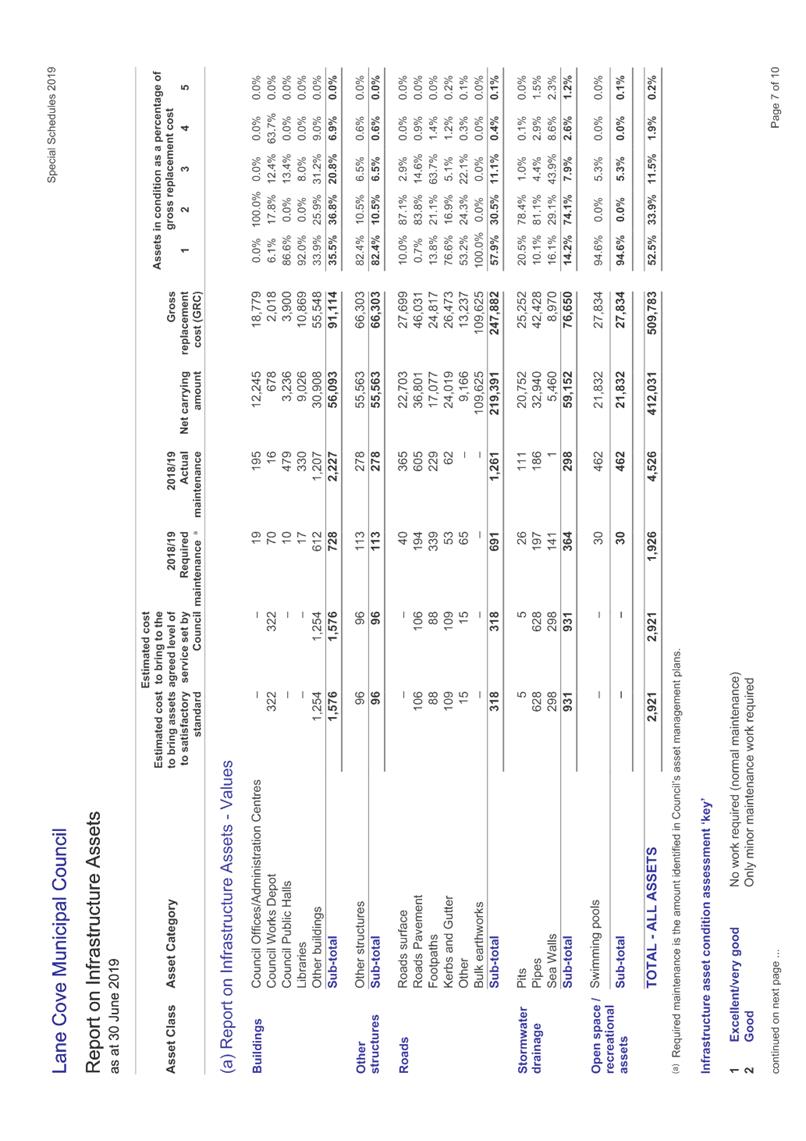
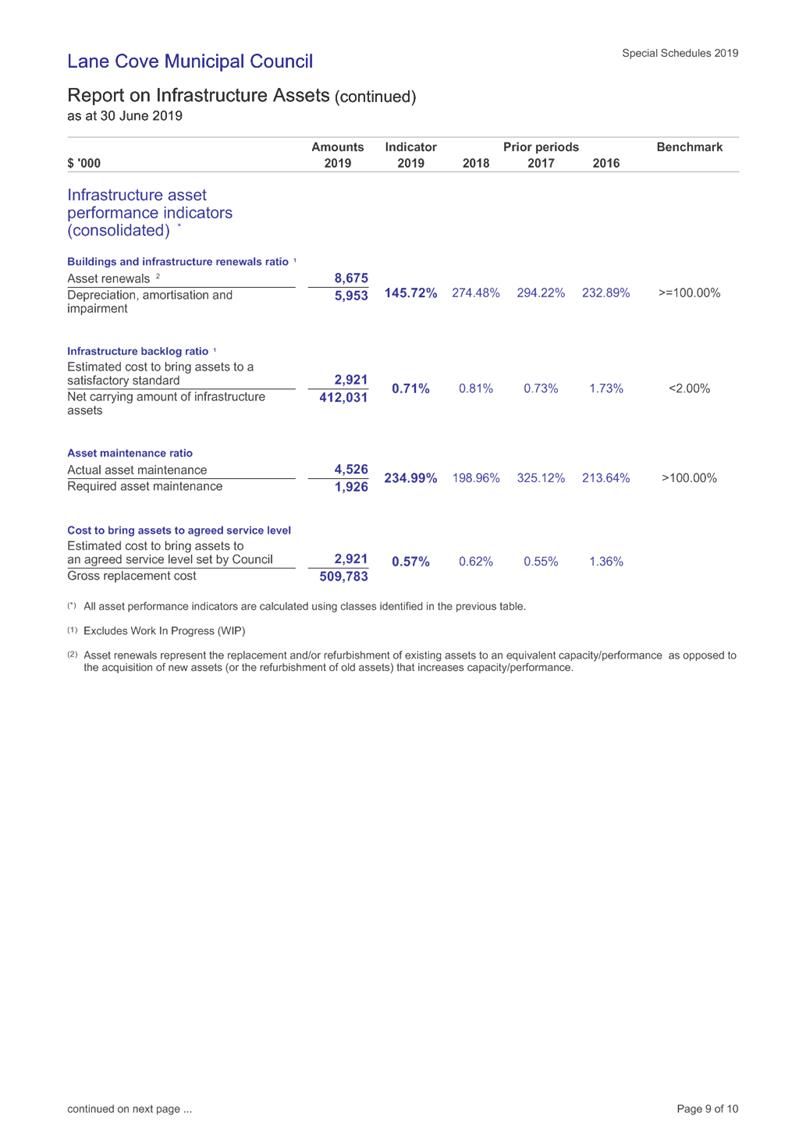
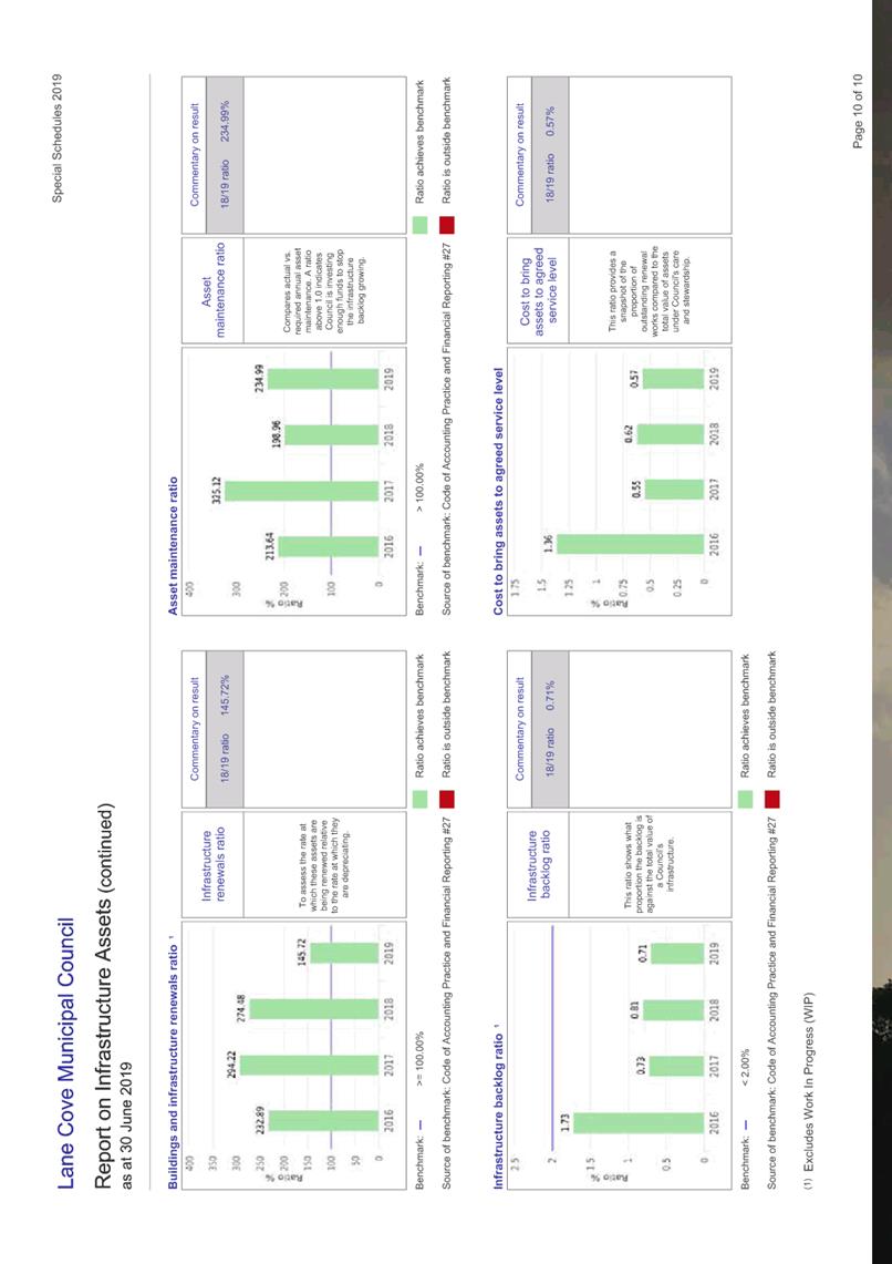

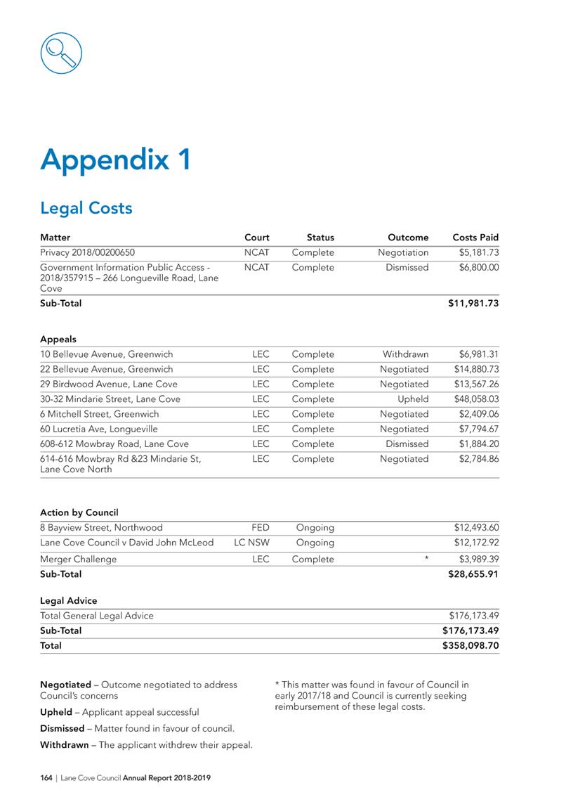


Ordinary Council Meeting 18 November 2019
Schedule of Meetings
2020
Subject: Schedule of Meetings 2020
Record No: SU1915 - 67432/19
Division: Corporate Services
Division
Author(s): Simon
Cole
The Ordinary Council Meeting Schedule for 2020 is proposed
as follows:-
|
Monday, 17 February 2020
|
|
Monday, 17 August 2020
|
|
Monday, 16 March 2020
|
|
Monday, 21 September 2020
|
|
Monday, 20 April 2020
|
|
Monday, 19 October 2020
|
|
Monday, 18 May 2020
|
|
Monday, 16 November 2020
|
|
Monday, 22 June 2020
|
|
Monday, 7 December 2020
|
|
Monday, 20 July 2020
|
|
|
There is no Council meeting in January
2020. NSW schools are back from holidays on
Monday, 20th July 2020 and the dates for the LGNSW Annual Conference
are from the 11th to 13th October 2020.
|
RECOMMENDATION
That the Council Meeting Schedule for 2020 be adopted.
|
Jessica Quilty
Acting Executive Manager
Corporate Services Division
ATTACHMENTS:
There are no supporting documents for this report.
Ordinary Council Meeting 18 November 2019
Council Snapshot October
2019
Subject: Council Snapshot October 2019
Record No: SU220 - 67730/19
Division: General Managers
Unit
Author(s): Craig
Wrightson
Executive Summary
Attached for the information of Councillors
is a review of Council’s recent activities. This report provides a
summary of the operations of each Division for October 2019.
|
RECOMMENDATION
That the report be received and noted.
|
Craig Wrightson
General Manager
General Managers Unit
ATTACHMENTS:
|
AT‑1View
|
Council Snapshot October 2019
|
42 Pages
|
|
|
ATTACHMENT 1
|
Council Snapshot October 2019
|