Lane Cove Local Planning Panel Meeting 17
December 2020
Planning Proposal No. 38
- 46 Nicholson Street, St Leonards
Subject: Planning
Proposal No. 38 - 46 Nicholson Street, St Leonards
Record No: SU8044 - 55878/20
Division: Environmental
Services Division
Author(s): Lara
Fusco; Terry Tredrea; Christopher Pelcz
|
Property:
|
46-52 Nicholson Street and 59-67 Christie Street, St Leonards
|
|
PP No:
|
Planning Proposal No.
38
|
|
Legal Description:
|
· Lot 11 in DP 654462;
· Lots A & B in DP 334878;
· Lot 2 in DP 945933;
· Lot 2 in DP 528060;
· Lot 1 in DP 9409064;
· SP54127; and
· SP18047.
|
|
Date Lodged:
|
24 July 2020
|
|
Owner (Proponent):
|
Jemalong Property
Group
|
|
Applicant:
|
Ethos Urban
|
|
Site Area
|
2,300 m2
|
|
Description of Proposal
|
Jemalong seeks to redevelop the site for a 32 storey
commercial office building by:
· Increasing the FSR controls from 4.5:1 to
16.45:1; and
· Introducing a solar height plane control to
Newlands Park to control building height.
|
|
Planning Proposal
documents
|
Links to all the
proponent’s documents are provided in Attachments at the end of this
report (AT-1 to AT-17).
|
|
Relevant Strategic
Planning documents
|
A Metropolis of
Three Cities – dated March 2018
North District
Plan – dated March 2018
Final St
Leonards/Crows Nest 2036 Plan – dated 29 August 2020 (AT-13)
Lane Cove Local
Strategic Planning Statement 2020 – dated 30 March 2020 (AT-14)
Lane Cove Local Environmental Plan 2009
|
|
Recommendation
|
That Planning
Proposal No. 38 be supported only if its amended to introduce a reduced
height control of RL 175.2 metres and reduced FSR of 15:1, and then be
forwarded to the Minister for a Gateway Determination.
|
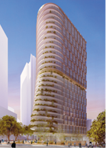
Figure 1: Proposed commercial office building
PURPOSE OF REPORT
The Lane Cove Local Planning Panel is requested to consider
and provide its advice on Planning Proposal No. 38.
REASON FOR REFERRAL
The Planning Proposal is referred to Council’s Local
Planning Panel under Section 9.1 of the Environmental Planning and
Assessment Act 1979. This Section requires referral of any Planning
Proposal to the Local Planning Panel for advice with an assessment report which
sets out recommendations in relation to the Proposal and whether it should be
forwarded to the Minister under Section 3.34.
The Planning Proposal fails to meet
any of the following matters for exemption from referral:-
a) the
correction of an obvious error in a local environmental plan;
b) matters
that are of a consequential, transitional, machinery or other minor nature; or
c) matters
that Council’s General Manager considers will not have any significant
adverse impact on the environment or adjoining land.
Therefore, the Planning Proposal must be referred to the
Local Planning Panel for advice prior to Council making any determination on
the matter.
EXECUTIVE SUMMARY
The purpose of this report is to
consider the planning merits and seek the Panel’s advice on the proposal
to redevelop the site into a commercial office building, for land at 46-52
Nicholson Street and 59-67 Christie Street,
St Leonards.
It is important to note that this
Proposal was lodged prior to the release of the final St Leonards and Crows
Nest 2036 Plan in August 2020. The applicant has provided an updated analysis
to respond to the final plan, which is attached.
The Proposal (AT-1) currently
seeks to retain the existing B3 Commercial Core zoning with an increase in
floor space ratio and height to permit a single 32 storey commercial office
tower development.
Planning Proposal 38
is also accompanied by:
· Appendix A: Urban Design Report (AT-2),
· Appendix B: View Impact Statement (AT-3),
· Appendix C: Traffic and Transport Assessment (AT-4),
· Appendix D: Economic Impact Assessment (AT-5),
· Appendix E: Proposed LEP maps (AT-6),
· Appendix F: Sustainable Timber Construction (AT-7),
· Vision Statement (AT-8),
· Addendum Information – Letter from applicant (AT-9),
· Addendum Information A – St Leonards and Crows Nest
2036 Plan comparison
(AT-10),
· Addendum Information B – Friedlander Place View
Corridor (AT-11),
· Addendum Information C – Christie Street Reserve Solar
Study (AT-12),
· Applicant letter – response to Council’s
preferred option (AT-16),
· Applicant’s revised massing – response to
Council’s preferred option (AT-17).
The
applicant’s letter (AT-9) has stated that it is willing to enter
into a Voluntary Planning Agreement with Council but this is not the subject of
this referral. Council’s adopted policy is that any VPA would be assessed
separately by Council at a later stage to ensure that any Planning Proposal is
considered on its own merit.
The Panel is requested to review and consider issues
proposed by the proponent along with the views and concerns raised in this
report. In particular, that Planning Proposal No 38 is not supported in its
current form. Council’s preferred option reduces and specifies the height
of building at RL175.2 and FSR of 15:1.
The proponent has agreed to accept the heights and FSR
limits in Council’s preferred option. Overall, Council’s preferred
option is supported for the following reasons:
· Passes strategic merit test, as it is consistent
with the following plans and documents:
o A Metropolis of Three Cities, which identifies the St Leonards Strategic
Centre as a major employment asset of the Eastern Economic Corridor for
“attracting investment, business activity and jobs in strategic centres
across Greater Sydney, close to people’s homes and supporting the 30-minute
city.” (p 119).
o The North District Plan's priorities or
actions for the St Leonards Commercial area, which identifies “the
importance of the precinct as a key employment centre in Greater Sydney”.
o The overall vision, objectives related to Employment,
Movement, Tree Canopy and Built Form objectives (and actions) of the St
Leonards/Crows Nest 2036 Plan. As it would –
i. strengthen the precinct
through employment opportunities with an A-grade commercial office space
providing over 3,000 new jobs;
ii. activate the public domain by ground floor links towards
Friedlander Place
iii. minimise overshadowing to neighboring recreation spaces
(Newlands Park and the new St Leonard’s Park); and
iv. retain and enhance the existing tree canopy and colonnade.
o The Proponent’s proposal exceeds the 2036
Plan's prescriptive measures. Council's preferred option, by contrast, is not
inconsistent with the floor space ratio and building height of the St
Leonards/Crows Nest 2036 Plan. Council’s preferred option is also
consistent with the Plan’s actions to minimise overshadowing and views
impacts to adjoining neighbours, and reduced parking rates for new
developments.
o Planning Priorities 6, 7 and 11 of
Council’s Local Strategic Planning Statement, which support the creation of public spaces and
facilities that improve our community's quality of life; also meeting the
precinct's jobs target, provision of standalone commercial office space, and
delivery of a sustainable commercial tower with a minimum target of a 6 Star Green rating.
· Passes the following aspects of the
site-specific merit test, as:
o It would develop commercial premises in this
location that is consistent with recent development and leasing activity.
o It has appropriately responded to any change in
circumstances (given compliance with 2036 Plan objectives).
o It reduces the provision of on-site parking
which would result in reduced traffic impacts on the surrounding road network
– this is also consistent with the action of the St Leonards/Crows
Nest 2036 Plan.
o Council's preferred option has provided a
moderated building envelope of reduced height to mitigate concerns and achieve
better consistency with the 2036 Plan’s controls.
The height and bulk of the Proponent’s
proposal would result in an unacceptable loss of district and iconic views for
existing residential properties in the vicinity.
It should be noted that some view sharing is to
be expected for residential use in a central business district, where
residential use is ancillary to the commercial function of the precinct.
SITE
The site is
located at 46-52 Nicholson Street and 59-67 Christie Street, St Leonards
(Figure 2).
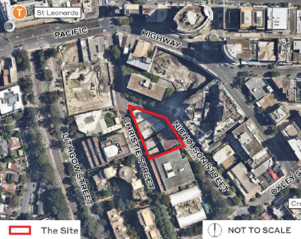
Figure 2: Location of proposal
The site contains six commercial buildings ranging in
height from two to four storeys, which are reaching the end of their economic
lifespan, are in poor repair and in some cases unusable. The eight lots have
been combined under a single landholding ownership.
Much of the
land on the north and south side of the Pacific Highway has been redeveloped
with larger mixed-use buildings and several underdeveloped properties are
subject to development consent. Further north of the site is ‘The
Forum’ which forms a town centre of St Leonards and acts as a commercial,
retailing and transport hub.
Current
Planning Controls
The
current planning controls for the site are as follows:
|
|
Legal Description
|
|
Zoning
|
B3 Commercial Core
|
Site compromised of:
· Lot 11 in DP 654462;
· Lots A & B in DP 334878;
· Lot 2 in DP 945933;
· Lot 2 in DP 528060;
· Lot 1 in DP 9409064;
· SP54127; and
· SP18047.
|
|
Site Area
|
2,300 sqm (proposal)
|
·
| Current
FSR |
4.5:1
|
|
Possible GFA
|
10,350 sqm
|
|
Height Limit
|
25 m
6-7 (storeys)
|
Table 1: Current Planning Controls
If developed entirely for Commercial
purposes, under current Lane Cove LEP controls, a potential building could be 6
– 7 storeys in height.
BACKGROUND
Council’s approach to
re-vitalising St Leonards has been detailed in previous reports to the Panel
and Council.
In pursuing the revitalization of the St Leonards CBD,
Council has taken a measured approach by targeting specific sites to stimulate
and broaden the economic base, by permitting a small number of mixed use (B4)
sites within the CBD as a whole. The remainder of the sites were to remain as
B3 Commercial Core. This approach has been implemented since 2012, through
Council’s:-
1. Four Pilot projects;
2. Proposed Rail Plaza; and
3. St Leonards Public Domain Master
Plan.
This targeted approach, with supporting projects, is a
finely tuned policy designed to stimulate the centre’s long-term
commercial and employment potential with residential development providing a
supporting role in the St Leonards CBD. Council is firmly of the view that
further residential land uses should only be considered after the 4 pilot
projects have been evaluated to gauge impacts and benefits to the Commercial
Core.
The Greater Sydney Commission has confirmed this approach
as consistent with the North District Plan which states that Councils “Strengthen
St Leonards through approaches that [in part] grow jobs in the centre
(Action 34). It aims for a high jobs growth target of 16,400 between 2016 and
2036. The precinct is important “as a key employment centre in Greater
Sydney”. “Employment growth is the principal underlying
economic goal for metropolitan and strategic centres” (North
District Plan: 2018, page 67) such as this.
While this Planning Proposal in
principle validates Council’s approach, there are now other (finalised)
strategic planning documents to consider. The State Government has released
their final 2036 Plan for the St Leonards/Crows Nest area, with an accompanying
Special Infrastructure Contribution. Council’s adopted Local Strategic
Planning Statement should also be considered.
These documents and their
relationship to this site are briefly outlined below.
St
Leonards and Crows Nest 2036 Plan
The St Leonards/Crows Nest Planned Precinct is identified
by the North District Plan (NDP) as “a mixed-use centre with high-rise
offices, and high-density residential development”. Action 34 of the NDP
focuses growth subject to “growing jobs in the centre”.
Additional capacity for housing supply is a secondary but important function of
the precinct. It is from these two purposes of the North District Plan that the
2036 Plan has emerged.
The NSW Department of Planning and Environment released the
Draft 2036 Plan and supporting documents for the St Leonards and Crows Nest
Planned Precinct for community consultation from October 2018 to 8 February
2019.
The final 2036 Plan for the area was released on 29 August
2020, it required that this site remain as B3 Commercial Core with an increased
height and floor space ratio (see Discussion section). The Plan also introduced
a Special Infrastructure Contributions rate to apply to all new residential and
mixed-use residential development in the area.
It is important to note that page 63 of the final 2036 Plan
states that all controls shown in the ‘Implementing the Plan’
section are indicative only. Further, on page 76:
“Planning Proposals may be
inconsistent with the Plan if it can be demonstrated to the Secretary
of the Department of Planning, Industry and Environment that the
inconsistency is of minor significance while still achieving the vision,
objectives and actions identified in the Plan”.
Special
Infrastructure Contributions
Note that as part of the final 2036 Plan, the Special
Infrastructure Contribution (SIC) is to apply to this area of St Leonards and
Crows Nest. However, because this site is proposed to be a commercial office
building, the SIC would not apply to this site.
Lane Cove Local Strategic Planning Statement
Council's adopted Local Strategic Planning
Statement outlines a 20 year vision, planning priorities and actions for land
use in Lane Cove. It was on exhibition from
Thursday, 5 September 2019 to Thursday 17 October 2019. The LSPS was adopted by
Council and sent for Assurance Review in February 2020.
A letter of support from the Greater Sydney Commission was
received for the final LSPS on 27 March 2020, which confirms that
Council’s Statement is consistent with both the Greater Sydney Region
Plan and North District Plan. The LSPS
came into force on 30 March 2020 and
published to the NSW Planning Portal website.
This Statement and other relevant documents must
now be used to inform future amendments to Council's Local
Environmental Plan and Development Control Plan. The Proposal’s
consistency with this Statement is detailed in the Discussion section of this
report.
PROPOSAL
The proponent-led Planning Proposal seeks the following
amendments to Lane Cove LEP 2009 (see proponent’s Draft LEP maps):-
· Increase the FSR controls from 4.5:1 to 16.45:1;
and
· Introduce a solar height plane control to avoid
shadowing of Newlands Park to control building height.*
* Height of building only to be defined by wording that:
“the development does not result in any additional overshadowing on the
land shown with blue hatching as ‘Newlands Park’– between
10.00am and 3.00pm on 21 June in each year”.
Overall, the proposed controls could potentially result in
the following outcomes:
|
|
CURRENT LEP CONTROLS
|
2036 PLAN
|
PROPOSAL
|
|
Zoning
|
B3 Commercial Core
|
B3 Commercial Core
|
Retain zoning
|
|
FSR
|
4.5:1
(commercial)
|
15:1
(indicative)
|
15.96:1
(commercial)
|
0.49:1
(retail)
|
16.45:1 (Total)
|
|
Gross Floor
Area
|
10,350 sqm
(commercial)
|
34,500 sqm
(indicative)
|
36,693 sqm (commercial)
|
1,149 sqm (retail)
|
37,842 sqm (Total)
|
|
Height
|
25 metres
(6-7 storeys)
|
30 levels/storeys - indicative
(no height shown in metres or RL)
|
Solar height plane control (to Newlands Park) but proponent’s
plans show RL 198.6m
(32 storeys)
|
|
Parking Spaces
|
367
(based on Council’s parking controls)
|
No control, but action to “limit the amount of
car parking provided for new developments”.
|
122
|
Table 2: Current and Proposed Planning
Controls
This would result in:-
· A 32 storey commercial office building with a total GFA of
37,842 sqm (FSR of 16.45:1), including ground floor retail and top two levels
of plant;
· Three levels of basement car parking with capacity for 122
car spaces with access from Christie Street;
· Above-ground balconies (up to Level 27);
· Public domain improvements including an activated ground
floor with public open space on the corner of Christie Street and Nicholson
Street, and public through-site link from Christie Street to Nicholson Street;
· Roof top garden terraces;
· Above ground outdoor balcony space for over half the floors; and
· 3 meters setback (at ground level) to all frontages and
rear boundary.
Refer to Figure 3 below.
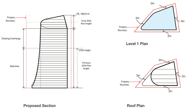
Figure 3: Concept elevation and footprint
Council’s Preferred Option
In response to the negative impacts of the
applicant’s proposal on the amenity of nearby residents (see Discussion
item iii below.- District views from residential neighbours impacted),
Council sought external advice from planning firm Architectus to consider
alternative built forms for the subject proposal (see AT-15).
The alternative building envelope
recommended for the proposal comprises the following:
• 26
storeys, with 24 office floors plus a plant level plus part rooftop plant;
• 15:1
FSR;
• 8
storey podium (street wall height) with 0m setback only along Christie Street;
• 3m
setback to Nicholson Street and southern boundary (rear); and
• 3m
setback above podium.
This reduction in height responds
to concerns, by reducing the impacts of over-looking and loss of district views
to adjoining/neighbouring residences, as well as transitioning the height and
bulk more appropriately to the surrounding context (see Figure 4). The reduced
FSR of 15:1 is consistent with the 2036 Plan.
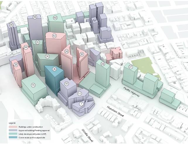 Figure 4: Council’s alternative
option
Figure 4: Council’s alternative
option
DISCUSSION
This section examines the provisions of the
proponent’s Planning Proposal against the strategic and site-specific
merit tests, as well as consistency against Council’s Local Environment Plan.
It also considers the relative merits of Council’s preferred option.
When considering a Planning Proposal, A guide to preparing Local Environmental Plans (prepared
by NSW Department of Planning & Environment) addresses the following
strategic and site-specific merit tests in assessing proposals.
Strategic Merit test:
1. Does the
Planning Proposal give effect to regional plan outside of the Greater Sydney
Region, the relevant district plan within the Greater Sydney Region, or
corridor/precinct plans applying to the site, including any draft regional,
district or corridor/precinct plans released for public comment?
a) A Metropolis of
Three Cities
It is claimed that the Proposal supports the achievement of
the regional Planning Priority N12: Delivering integrated land use and
transport planning and a 30-minute city, and Objective 14 – A
Metropolis of Three Cities – integrated land use and transport creates
walkable and 30-minute cities.
Comment:
The Proposal is consistent with Objective 22 of A
Metropolis of Three Cities. This objective states that the expectations
of all strategic centres include both:
· “co-location of a wide mix of land
uses, including residential” (page 118);
· “areas identified for commercial
uses, and where appropriate, commercial cores” (page 119).
· “Employment growth is the principal underlying
economic goal for metropolitan and strategic centres (page 119).
· A balance is required in providing adequate mixed use or
residential zoned land around a commercial core that allows new residential developments to benefit from
access and services in centres” (A
Metropolis of Three Cities, page 120).
Based on these considerations, Council’s existing
land use approach and programs of targeting just four key sites around open
space for mixed use development (i.e. pilot projects) achieves the directions
specified in both A Metropolis of Three Cities and the North District
Plan. This approach seeks to achieve an appropriate balance between
commercial and residential development and supports a commercial-only
development on the subject site at this time.
The Proposal’s commercial only approach is considered
to be consistent with the objectives and expectations (of strategic centres) of
A Metropolis of Three Cities.
b) North
District Plan:
It is claimed that the District Plan also contains specific
actions for St Leonards. Relevant actions that the proposal is consistent with
included:
· Leverage the new Sydney Metro Station at Crows
Nest to deliver additional employment capacity;
· Grow jobs in the centre;
· Reduce the impact of vehicle movements on
pedestrian and cyclist accessibility; and
· Deliver new-high quality open space, upgrade
public areas, and establish collaborative place-making initiatives.
Comment:
Both A Metropolis of Three Cities and the North District Plan (NDP) identify St
Leonards as a ‘strategic centre’. The District Plan considers that
the strategic centres play an important economic role in supporting the growth
of Sydney as a global city. Particularly as a health and education (employment)
‘super precinct’ (page 60).
Council must assess this planning proposal against Planning
Priorities N9 & N10 and Action 34 of the District Plan, in regards to St
Leonards.
Planning Priority N9: Growing and investing in
health and education precincts
Page 64 reinforces “the importance of the precinct as a key employment
centre in Greater Sydney”. Action 34, a Productivity Action, is primarily focused on
additional employment capacity by growing jobs. In particular, a higher jobs
target of an extra 16,400 jobs identified by 2036.
This Proposal states that it would realise 3,430 additional
jobs (21%) of the total employment potential of the strategic centre of St
Leonards Crows Nest. Medical office suites are also proposed to be
delivered at the lower levels of the building. This would further support the
health and education precinct of St Leonards and Royal North Shore Hospital.
Council’s preferred option, with an FSR of 15:1 is
consistent with the 2036 Plan and contributes to the precinct’s high jobs
target in a manner similar to the applicant’s proposal.
Planning Priority N10: Growing investment,
business opportunities and jobs in strategic centres
Page 67 of the NDP reinforces that, “the
growth, innovation and evolution of centres will underpin the economy of the
North District.”
The Proposal is consistent with the central objective of
supporting an employment hub, such as St Leonards, that can provide 16,400
additional jobs over the next 20 years. If combined with Council’s
‘pilot project’ sites, approximately 4,691 additional jobs will be
created in the Lane Cove portion of St Leonards. This would be counted towards
the high jobs target for the area.
c) St Leonards/Crows
Nest 2036 Plan:
The Planning Proposal argues that it is consistent with the
Vision and Area Wide Design Principles of the 2036 Plan. More specifically,
Table 3 in part addresses the Design Criteria which should be complied with,
and compares compliance by the applicant’s proposal with Council’s
preferred option.
|
|
Applicant’s Proposed
|
Council’s Preferred
|
2036 Plan
|
|
Land Use
|
* Entirely commercial
* in A-grade office
|
* Entirely commercial
* in A-grade office
|
* Entirely commercial
* in A-grade office
|
|
FSR
|
16.45:1
(15.96:1 =
commercial; 0.49:1 = retail)
|
15:1
|
15:1 (indicative)
|
|
Height
|
32 storeys (approx.
RL 198.6)
No actual height
control (based on no overshadowing of Newlands Park by 10am)
|
26 storeys
(RL175.2)
|
30 storeys
(indicative – no height)
|
|
Setbacks
|
3m. (only tapers
upward on western corner)
South-east side;
3m towards rear
boundary.
|
0m setback along
Christie; 3m to Nicholson and rear boundary;
8 storey street wall
height;
Further 3m above
podium.
|
3m setback;
4 storey street wall
height;
Activate corner
streetscape
|
|
Parking
|
122 spaces (3 level
basements)
|
122 spaces (3 level
basements)
|
Keep parking to a
minimum
|
|
Overshadowing
|
No impact on Newlands
Park after 10am.
|
Further reduced
impact on Newlands Park.
|
Avoid
“substantial additional overshadowing” 10-3
Newland Park
& new park (p37)
* Minimise
overshadowing of adjoining residential
|
|
Connections
|
Provides:
* mid-block
pedestrian link;
* 3m colonnade along
both streets (in addition to 3m setbacks on both streets)
|
Provides:
* mid-block
pedestrian link;
* 3m colonnade along
both streets (in addition to 3m setback on Nicholson)
|
East-west ped.
connection from Plaza to Crows Nest station via Nicholson.
North-south bike path
down Christie
|
Table 3: Design Criteria Assessment
against 2036 Plan
Within this section of Strategic Merit, the Proposal is
assessed in terms of design elements of the 2036 Plan.
Positives:
· An increase in employment (jobs) to meet the
Precinct’s high jobs target;
· A-grade office space (no residential);
· Capacity to achieve a 6 star-green energy and
NABERS rated building;
· Activated ground floor links towards Friedlander
Place;
· Minimises shadowing of Newlands Park;
· Colonnade along Nicholson and Christie Streets.
Concerns:
i. Height & FSR above 2036
Plan;
ii. Uncertain height defined by
solar impact on Newlands Park;
iii. District
views from residential neighbours impacted;
iv. Christie
St park overshadowed till approx. 1.30pm;
v. Overshadowing of adjacent
residential;
vi. Amount
of tree canopy cover;
vii. Traffic
network impacts.
These seven issues of possible concern are addressed below.
i. Height
and FSR above 2036 Plan limits
The applicant’s proposed height
of the building is 32 storeys which is two storeys above the 2036 Plan of 30
storeys. The applicant’s FSR of 16.45:1 is 1.45:1 above the FSR of the
2036 Plan.
Comment:
The indicative number of storeys and
indicative proposed floor space ratios for the site and its surrounds under the
2036 Plan are shown in AT-13 (on pages 66 and 67).
Note that the proposed Ground floor
provides approximately 575m2 of public open space. This reduces the
effective (private) FSR down to 16.2:1.
The proposed 3m ground level setback
and 4 storey street wall height, the other contributor to perceived bulk and
scale, is consistent with the 2036 Plan (as shown in Figures 3 and 5).
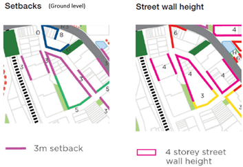
Figure 5: Setbacks in 2036 Plan
Notwithstanding the proposal’s compliance with the
2036 Plan for setbacks and street wall heights, variations to the indicative
FSR and height in storeys is not supportable from an amenity perspective.
Modifications to the height, FSR and setbacks of the
proposal were investigated by Council and are addressed elsewhere in this
report (refer to Council’s Preferred Option).
Based on the controls in the final
2036 Plan, the applicant created an indicative maximum building envelope (see AT-9)
using the setbacks shown in Figure 5 to achieve the indicative storeys shown in
the final 2036 Plan (AT-13, page 66). The resulting floor space ratio
(shown in Figure 6) is significantly larger than the FSR in the final 2036 Plan
at 18.4:1 and achieve approx. 42,000 sqm of gross floor area.
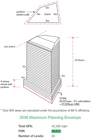
Figure 6: Maximum
building envelope using final 2036 Plan controls
It is noted that Figure 6, shows a commercial office
development which would comply with setbacks and indicative heights shown in
the final 2036 Plan.
However, the applicant’s proposed design (planning
envelope) reduces the impacts on surrounding properties by a modified building
envelope articulation compared with the final 2036 Plan – see Figure 7.
This is discussed further in section iii District views
from residential neighbours impacted.
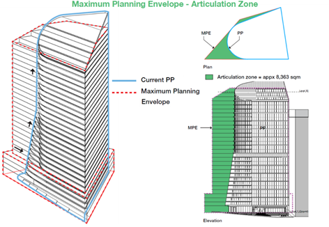
Figure 7: Applicant’s
proposed envelope
ii. Uncertain
height defined by solar impact on Newlands Park
It is proposed to define height in
terms of a solar height plane to Newlands Park where no shadow falls on
Newlands Park between 10.00am-3.00pm on 21 June. This was a requirement of the
2036 Plan.
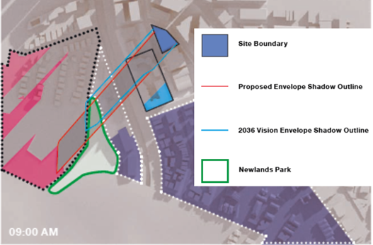
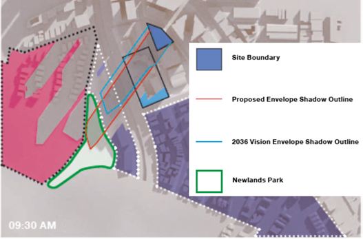
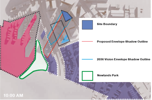
Figure 8: Shadow
modelling at 9am, 9:30am and 10am
Comment:
This
is no longer a requirement of the final 2036 Plan. One of the new actions on
page 33 of the 2036 Plan states that new development must:
“Minimise overshadowing of key open
spaces, public places and adjoining residential areas. Solar height planes
should be adhered to as indicated within the Solar Access Map” (page 33
of 2036 Plan).
When read in conjunction with the
solar access map (on page 38 of the Plan), it is made clear that any new
building must seek to ‘minimise overshadowing of key open spaces’
between the hours of 10am – 3pm (mid-winter), in this case Newlands Park.
Notwithstanding that, shadow
modelling in Figure 8 shows that the proposed building will not overshadow
Newlands Park at all after 10am mid-winter. Therefore, the proposed LEP height
control in the Planning Proposal is no longer applicable to the action of the
final 2036 Plan.
An RL, as seen in the
applicant’s proposal (RL 198.6 metres) and/or equivalent height in metres
gives assurance of height to adjoining land owners. Conversely, the definition
of height in terms of a solar height plane is uncertain and unnecessary in this
Planning Proposal due to a new action in the final 2036 Plan. It is recommended
that the Panel advise that the applicant’s Planning Proposal be amended
to remove the proposed LEP height control (expressed as a solar height plane)
and replace it with an RL. Council’s preferred Option of 26 floors is
equivalent to RL175.2.
iii. District
views from residential neighbours impacted:
Impacts on district views, including
iconic views (to the Sydney Harbour Bridge and the Sydney CBD) are partly
addressed in the applicant’s Urban Design Report (AT-2), and View
Impact Assessment (AT-3).
The greater articulation towards Nicholson Street, would
reduce the potential visual impact for the properties in nearby Landmark
development (500-504 Pacific Highway, St Leonards). It would also maintain an
important view corridor (from the Abode building in North Sydney towards
Friedlander Place) which was a key part of Council’s original
‘pilot project’ approach to the area.
Using these assessments, plus
reference to the development consents for the nearby residential towers, the
visual impacts are measured from the nearby residential towers at 472, 486
(Mirvac development) and 504 (Landmark development) Pacific Highway, St
Leonards, as well as the soon-to-be-completed 88 Christie Street mixed-use
residential towers. These buildings are within the line-of-sight of this
Proposal. Views were measured from low, medium and high levels, and from
apartments between the far west and far east end of buildings.
Comment:
An impact comparison is made between
the proponent’s Planning Proposal 38 (32 storeys) and Council’s
preferred option.
In summary:
|
Height of top of the building
(in RL metres)
|
No. of storeys
|
46 Nicholson Street
Proposal
(RL 198.6; 32 storeys)
|
Council’s preferred option for 46
Nicholson Street
(RL 175.2; 26 storeys)
|
|
(Mirvac) Rear Tower
|
RL 204.46
|
35 levels + roof and plant
|
Approximately 2 storeys of unimpeded views
|
Approximately 9 storeys of unimpeded views
|
|
(Mirvac) Front Tower
|
RL 180.46
|
27 levels + roof and plant
|
Minimal impact
|
Minimal impact
|
|
504 Pacific Hwy (Landmark)
|
RL 227.4
|
43 storeys
|
Approximately 9 storeys of unimpeded views
|
17 storeys of unimpeded views
|
|
88 Christie St (JQZ)
|
RL 227.31
|
47 storeys
|
Approximately 15 storeys of unimpeded views
|
21 storeys of unimpeded views
|
Table 4: View impacts
Table 4 shows that under the
applicant’s proposal (RL198.6; 32 storeys), district view losses occur
from 486 (Mirvac) and 504 (Landmark) Pacific Highway, and to a lesser extent
from 88 Christie (JQZ). View sharing (loss) is to be expected from residential use
in a central business district, where residential use is ancillary to the
commercial function of the precinct. Council’s preferred option (RL
175.2; 26 storeys) significantly increases the storeys with unimpeded views. It
is concluded that Council’s preferred option has a more moderate impact
on this nearby residential amenity of B4 Mixed Use towers.
iv. Christie
St park overshadowing
Figure 9 shows that the existing
Christie St park is within close proximity to the site. According to the applicant’s
studies it is overshadowed till 1.30pm. The 2036 Plan requires development to
avoid “substantial additional overshadowing” of Newlands Park &
the new St Leonards South park from 10am-3pm. This does not apply to Christie Street
Park (see Figure 9).
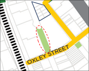
Figure 9: Christie
Street Park
Comment:
Shadow modelling (AT-2 p 66)
shows the park at the southern end of Christie Street would experience
overshadowing until approx. 1.30pm. While the 2036 Plan requires development to
avoid “substantial additional
overshadowing” of Newland Park & the new St Leonards South park from
10am-3pm (p 37), this does not apply to Christie Street Park.
Although the park would be protected under Council’s
current 25 metre height limit, the 30 levels stated in the 2036 Plan and 32
levels in this proposal would significantly overshadow Christie Street park.
Christie street enjoys a northern orientation and this is not altered by either
proposal.
The proposed development would need to be approximately
half its current height to result in any reduction in overshadowing of the
park. This is an onerous requirement of a commercial building in a Commercial
Core zone and is against the intent, objectives and actions of the 2036 Plan.
v. Overshadowing
of adjacent residential
The 2036 Plan (AT-13) requires
that development “Minimise overshadowing of … adjoining
residential areas.” The solar access map states that this applies to
“residential areas inside the boundary (for at least 2 hours)”
Comment:
The proponent’s shadow
modelling is contained on pages 64-71 (in AT-2). It highlights that in:
· Lithgow Street residential (Northmark/Shoremark) –
shadow gone by 12:15 pm. (i.e. 2.75 hours in pm). Additional shading is very
similar to 2036 Plan potential shadowing.
· Duntroon Ave – shadow gone by 12:30pm.
· Canberra Ave –
shadow gone by 9:30am.
These are considered acceptable levels of solar access as
defined by the final 2036 Plan and Apartment Design Guide. It is noted that
this is a commercial office building and such high standards (as defined in the
Apartment Design Guide) do not necessarily apply to this site. Council’s
preferred option is lower in height, so its shadow impacts would be reduced
further than the applicant’s.
vi. Amount
of tree canopy cover
A tree canopy cover target of 25.7%
has been identified for this ‘urban’ sub-precinct in the 2036 Plan
(AT-13 pp 3 and 29). This is not addressed in the Planning Proposal or
its documents.
Comment
In the 2036 Plan vision map (see AT-13
pg 6), Nicholson Street is identified as a “tree-lined green street”
while Christie Street is not. The objectives are to “incorporate new
street trees to realise the tree canopy targets” (AT-13 pg 10)
but there are no related actions that apply to this site (see AT-13 pg
27).
The proponent’s ground floor
plan (seen in Figure 10) shows that there is consistent street tree planting
proposed along both street frontages (Nicholson and Christie Streets) but the
exact amount of tree canopy cover has not been specified by the proponent.
However, as stated above, there are no
direct actions in the 2036 Plan on tree canopy cover which affect this site
(see AT-13, pg 27). Notwithstanding this, it appears that there is
potentially enough space to accommodate increased tree planting if needed,
based on the proposed ground floor plan (seen in Figure 10).
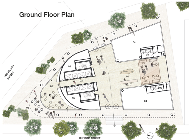
Figure 10: Ground floor proposal
The street tree plantings indicatively proposed along
Nicholson Street are consistent with the vision of the ‘tree-lined
street’, with the addition of tree plantings on the site (along Christie
Street which currently has limited or no trees – see AT-1 pp 17-18)
will achieve the objective and will likely realise increased tree canopy cover
across both streets. Nevertheless, the applicant is requested to specify the
tree canopy cover in an amended Planning Proposal.
vii. Traffic
The proponent’s traffic and
transport study (AT-4) states that:
“… will not result in
adverse impacts on the surrounding road network. All intersections retain an
acceptable level of service during both the AM and PM peak hours, with no
additional measures required to accommodate future traffic demands.” (AT-4 p.
25).
Comment:
Parking is proposed for 122 bays which is lower than
Council’s DCP Part R requirement (see Table 2). It is much closer to the
rate for North Sydney which specifies 1 space/400m2 GFA (using this
calculation the proposal would provide approximately 92 parking spaces).
It is also consistent with the action of the 2036 Plan to “Limit the
amount of car parking provided for new developments”.
The
proponent’s traffic and transport study (AT-4) also outlines a
Green Travel Plan with a suite of measures to reduce
the need to travel and promotion of sustainable means of transport. This
includes cycling, walking, public transport (St Leonards train station and
Crows nest Metro), and carshare/carpooling. All of these measures are
consistent with Part R of Council’s Development Control Plan and will
assist in achieving the action of the 2036 Plan. Hence the impacts on the
surrounding network are considered acceptable.
Entry to the basement is proposed off Christie Street (at
the south-east end). Council’s DCP suggested off Nicholson (thereby
forcing southbound arrivals to turn across Nicholson). By this route the
proposed entry is a preferable solution.
2. Does
the Planning Proposal give effect to a relevant local strategy that has been
endorsed by the Department, such as the local strategic planning statement,
housing strategy?
Council’s Local Strategic
Planning Statement (LSPS):
Council’s local strategic
planning statement (see AT-14) was formally endorsed by the Greater
Sydney Commission in March 2020.
Comment (LSPS):
Under the Productivity section,
Council states that:
“St Leonards had a base estimate of
47,100 jobs in 2016. By 2036, it is expected that St Leonards could accommodate
a higher jobs target of up to 63,500 jobs, an increase of 16,400 new jobs. Lane
Cove has already contributed to this higher jobs target as all four of its
pilot projects have now been approved with commercial/retail/office floor space
in excess of current planning controls. They provide an additional 22, 696 sqm
of non-residential floor space which translates to 1,261 new jobs (based on the
Draft 2036 Plan findings). In addition, a world class commercial tenant
MasterCard has now established a technology hub in an existing commercial
office building in St Leonards, highlighting the need for stand-alone
commercial office space”.
Council’s targeted approach to expansion,
involved leaving the remainder of the B3 Commercial Core area in Lane Cove LGA
as currently zoned, avoiding isolation of commercial sites. Further, these
pilot projects were to be monitored in terms of their effectiveness in
stimulating the commercial sector in advance of any consideration of similar
rezonings. Council’s pilot project approach and recent construction
approvals provide overwhelming evidence that stand alone commercial development
is now viable and may potentially become more viable as a result of Crows Nest
Metro Station according to the Draft 2036 Plan findings.
In its Draft 2036 Plan submission, Council
proposed not pursuing any further mixed use rezonings (as proposed in the Draft
2036 Plan) and a development phasing plan reviewing the Plan in 2026 after
delivery of the Sydney Metro project in 2024, to ensure opportunities for
commercial development are maximised.
…Council’s long term approach
outlined above would leverage off the Crows Nest Metro Station to deliver
additional employment capacity. It will also achieve a balance of commercial
and residential development in the St Leonards Strategic Centre”. (Local
Strategic Planning Statement: 2020, page 42).
This translates into the ongoing
action:
“Achieve a balance between the designated
commercial core and residential development in the St Leonards Strategic Centre
to manage the impact of residential development in crowding out commercial
activity” (page 44).
Council is mindful of providing for
jobs growth in the B3 zone of St Leonards, which the applicant’s proposal
is consistent with. Council’s preferred option, which compares the
applicant’s proposed FSR of 16.45:1 against Council’s preferred
15:1 FSR. The preferred GFA continues to support a substantial A-grade office
footprint that still achieves the NDP high jobs target.
3. Does
the Planning Proposal respond to a change in circumstances, such as the
investment in new infrastructure or changing demographic trends that have not
been recognized by existing planning controls?
As stated in previous reports, the new Metro Station at
Crows Nest will act as a catalyst for more stand-alone commercial office
development in the area.
Both the original Planning Proposal and Council’s
preferred option also respond to Council’s recent Climate Emergency
declaration by having a greater focus on sustainability (see AT-8).
Overall, the original Proposal and Council’s
preferred option have strategic merit as they are consistent with the existing
strategic planning framework for the area, respond to the investment by State
government in the Metro Station at Crows Nest, and respond to Council’s
Climate Emergency resolution. Reduced on-site parking should also be considered
given the location of the Metro Station and need to increase pedestrian
connectivity.
Site-specific Merit Test
If the Planning Proposal has demonstrated
strategic merit, then the site-specific merit test must have regard to:
4. the
natural environment (including known significant environmental values,
resources or hazards)
Significant environmental values or resources
are not likely to be impacted as a result of either the applicant’s
proposal or Council’s preferred option, nor is the land affected by any
known hazards.
5. the
existing uses, approved uses and likely future uses of land in the vicinity of
the land subject to a proposal
The proposed height and bulk of the applicant's
proposal would result in loss of district and iconic views for Mixed Use
residential uses along Pacific Highway. The Planning Proposal fails to
satisfactorily justify loss of view and amenity to existing dwellings beyond
the 30 levels specified in the 2036 Plan. The additional FSR of 1.45:1 sought
by the proponent cannot be justified on the grounds that it would achieve a
better planning outcome. Further, they have also failed to appropriately
consider the cumulative impacts of development on view loss.
The applicant responded to Council’s
preferred option (AT-16 and AT-17) and supported a reduced FSR of
15:1 but did seek an additional 10% (approximately 2-3 storeys) in height above
Council’s preferred 26 storeys, without giving a reason for this height.
As stated above this increased height (to approximately 28-29 storeys) fails to
consider and address the cumulative impacts of development on view loss.
Therefore, in response to this negative amenity
impact, Council's preferred option has provided a moderated building envelope
of reduced height to mitigate concerns. However, some view sharing is to
be expected from residential use in a central business district, where
residential use is ancillary to the commercial function of the precinct.
On 10 December 2020, the proponent confirmed
that the height and FSR limits in Council’s preferred option (RL 175.2
and 15:1) is accepted. The Panel is recommended to support this.
6. the
services and infrastructure that are or will be available to meet the demands
arising from the proposal and any proposed financial arrangements for
infrastructure provision.
The subject site is near to the Crows Nest Metro station,
due to open in 2024. As a result, off-street parking should consider this new
reality and address the requirements of Council’s DCP Part R in terms of
impacts. The reduced provision of parking would result in reduced traffic
impacts on the surrounding network, which Council supports.
CONCLUSION
Council has taken a balanced and measured approach to the
revitalization of the St Leonards CBD by targeting sites that will stimulate
and broaden the economic base to stimulate the centre’s long-term
employment potential.
The regional plan (A Metropolis of Three Cities)
describes St Leonards as “a major asset” of the Eastern Economic
corridor. It states:
“Attracting investment, business
activity and jobs in strategic centres across Greater Sydney increases access
to a wide range of jobs, goods and services close to people’s homes and
supports the 30-minute city.” (p 119)
Council’s approach is acknowledged in the North
District Plan where it defines St Leonards as a “strategic”
centre which plays an important economic role in supporting the growth of
Sydney as a global city. Particularly as a health and education (employment)
“super precinct”.
It also reinforces “the importance of the precinct
as a key employment centre in Greater Sydney”. Action 34 states that
St Leonards is primarily focused on additional employment capacity by growing
jobs and not permitting residential development to crowd out commercial
development.
Based on these considerations, Council’s preferred
option is considered to be consistent with both the Regional Plan and North
District Plan as it will allow for a commercial office building to provide jobs
which will contribute to the high jobs target for the area.
It is also in principle consistent with the vision,
objectives and actions of the final St Leonards/Crows Nest 2036 Plan.
The 2036 Plan provides the proponent with considerable FSR
and height above Council’s existing planning controls. The additional
height and FSR sought by the proponent represent an increase of 2 levels and
FSR of 1.45:1 (respectively) as stated by the 2036 Plan. These increases would
impact views and amenity of nearby residential towers.
The proponent endeavored to consider these potential
impacts by reducing the building envelope and encouraging pedestrian
connectivity at the street and within the building. The proposal results in a
significant negative impact on visual amenity in the vicinity. Council’s
preferred option will reduce these impacts (and others) with a more moderated
built form.
The land uses (commercial while accommodating pedestrian
connectivity) of the original and Council preferred proposals are also
consistent with Council’s Local Strategic Planning Statement Priorities
and Actions as they would achieve a balance in the St Leonards Commercial area
of residential and commercial development.
The final 2036 Plan Action is now to “minimise
overshadowing of key public open spaces” and the proposed LEP
amendment is not consistent with this. Even though it is likely that tree
canopy cover on site will be increased by the proposed development and achieve
the target of 25.7%, the proponent is requested to specify the amount of tree
canopy cover.
While the
proponent’s Planning Proposal No. 38 passes the strategic merit test, it
cannot be supported in its current form as submitted by the applicant, as it
fails the site-specific merit test on unacceptable visual amenity grounds.
Planning
Proposal No. 38 could be supported if amended by the introduction of a reduced
height control of RL 175.2 metres and a reduced FSR of 15:1. The proponent has
written to Council confirming that these height and floor space ratio
amendments are accepted. It is recommended that the Panel support these changes
and Planning Proposal No. 38 be amended accordingly.
|
RECOMMENDATION
Pursuant
to Section 9.1 of the Environmental Planning and Assessment Act 1979,
the Lane Cove Planning Panel at its meeting of 17 December 2020 is
recommended to support Planning Proposal No. 38, only with the following
amendments:
A. Amendments
· to show a (reduced) numerical height control of RL 175.2
metres; and
· reduce the proposed floor space ratio (FSR) to 15:1.
The
Panel is also recommended to advise Council to forward the amended Proposal
(stated in point A.) to the Minister of Planning for a Gateway
Determination, as it would pass the Strategic Merit Test and the
Site-Specific Merit Test for the following reasons:
B. Amended Proposal - Passes
Strategic Merit Test
Reasons
1) Is consistent
with A Metropolis of Three Cities, which identifies the St Leonards
Strategic Centre as a major employment asset of the Eastern Economic Corridor
for “attracting investment, business activity and jobs in strategic
centres across Greater Sydney, increasing access to a wide range of jobs,
goods and services close to people’s homes and supporting the 30-minute
city.” (p 119)
2) Is consistent
with the North District Plan's priorities or actions for the St
Leonards Commercial area, which identifies “the importance of the
precinct as a key employment centre in Greater Sydney”.
Particularly as a health and education (employment) "super
precinct". This Proposal would realise close to approximately 3,000
additional jobs of the total employment potential of the strategic centre of
St Leonards Crows Nest.
3) Is consistent
with the following aspects of the St Leonards/Crows Nest 2036 Plan:-
a. The Plan’s
vision will be achieved with this proposal because it will be ‘a
balance of commercial’ and contribute to the ‘sunny tree-lined
public spaces’.
b. The relevant
objectives of the Plan will be achieved as the preferred option has
considered the cumulative impacts of overshadowing and view loss and altered
the building’s design. The commercial offices will also ‘ensure
new employment sites in the area cater to a range of business types and
sizes’ while ‘protecting the site for future employment
uses’. The design also incorporates street tree planting which will
likely increase the tree canopy cover on the site to achieve the target.
c. Under Employment, (p 51) “The Plan
supports jobs within the precinct through the identification of five (5) key
employment areas including St Leonards requiring an extra 2,160 to 4,570 new
jobs by 2036”. The amended proposal focus on over 3,000 new jobs
supports this target.
d. The Plan seeks to “to encourage the
renewal of St Leonards through the delivery of new A-grade commercial floor
space…” (p 42). The amended proposal is for A-grade office
space (and no residential floor space).
e. Under Movement (p 55), the Plan aims to
“provide clear, continuous and direct pedestrian and cycle routes to
priority destinations such as St Leonards Station and surrounding commercial
core”. By activating ground floor links to Friedlander Place as
well as providing colonnades along both street frontages, the amended
proposal supports this action.
f. The amended proposal is consistent with the
action (p 37) to minimise substantial overshadowing of Newlands Park.
g. Under Tree Canopy (p 29) the Plan aims to
“retain and enhance the existing network of tree-lined
streets”. This is supported by the proposed street trees and
colonnade.
h. Under Built form, the Plan seeks to “consider
cumulative impacts of new developments on existing areas, including
overshadowing, wind impacts and view loss.” As addressed above, the
proposal as amended gives careful consideration of the cumulative
overshadowing and view impacts on the surrounding area.
i. The Plan seeks to “Limit the amount
of car parking provided for new developments.” As addressed above,
the reduced parking provision supports this Action.
4) Council’s
preferred option is not inconsistent with the floor space ratio and building
height of the St Leonards/Crows Nest 2036 Plan. The original proposal,
by contrast, exceeds the 2036 Plan’s prescriptive measures.
5) Is consistent
with the following aspects of Council’s Local Strategic Planning
Statement:-
a. Planning
Priority 6: Through the creation of a ground floor public domain and
through-site walkway, the proposal supports the creation of public spaces and
facilities to improve our community’s quality of life;
b. Planning
Priority 7: By meeting the precinct’s jobs target and provision of
standalone commercial office space, the proposal facilitates location of a
diverse range of retail, commercial and industrial businesses in Lane Cove;
and
c. Planning
Priority 11: The proposal is to comprise sustainable practice relating to
water and energy use and to deliver a highly sustainable commercial tower,
with a minimum target of a 6 Star Green rating, 5.5 Star NABERS Energy rating
and 4 Star NABERS Water rating, the proposal would Improve the management of energy,
water, and waste resources.
C. Amended Proposal - Passes
Site-specific Merit Test
Reasons
6) The proposal to
develop a commercial premise in this location is consistent with recent
development and leasing activity.
7) Due to the
compliances with the 2036 Plan objectives, design criteria, design principles
and actions, the proposal as amended has appropriately responded to any
change in circumstances.
8) In response to the negative
amenity impact of loss of district and iconic views for residential
properties in the vicinity, Council's preferred option has provided a
moderated building envelope of reduced height to mitigate concerns. It
should be noted that some view sharing is to be expected from residential use
in a central business district, where residential use is ancillary to the
commercial function of the precinct.
9) The reduced
provision of parking would result in reduced traffic impacts on the
surrounding network which is consistent with the action of the St
Leonards/Crows Nest 2036 Plan.
|
Mark Brisby
Executive Manager
Environmental Services Division
ATTACHMENTS:
|
AT‑1View
|
Planning Proposal 38
|
57 Pages
|
|
|
AT‑2View
|
Appendix A: Urban Design Report
|
79 Pages
|
|
|
AT‑3View
|
Appendix B: View Impact Statement
|
24 Pages
|
|
|
AT‑4View
|
Appendix C: Traffic and Transport Assessment
|
39 Pages
|
|
|
AT‑5View
|
Appendix D: Economic Impact Assessment
|
29 Pages
|
|
|
AT‑6View
|
Appendix E: Proposed LEP Maps
|
2 Pages
|
|
|
AT‑7View
|
Appendix F: Sustainable Timber Construction
|
2 Pages
|
|
|
AT‑8View
|
Vision Statement
|
4 Pages
|
|
|
AT‑9View
|
Addendum Information - Letter from applicant
|
9 Pages
|
|
|
AT‑10View
|
Addendum Information A - St Leonards and Crows Nest 2036
Plan comparison
|
9 Pages
|
|
|
AT‑11View
|
Addendum Information B - Friedlander Place View Corridor
|
5 Pages
|
|
|
AT‑12View
|
Addendum Information C - Christie Street Reserve Solar
Study
|
4 Pages
|
|
|
AT‑13View
|
Final St Leonards and Crows Nest 2036 Plan
|
80 Pages
|
|
|
AT‑14View
|
Local Strategic Planning Statement
|
83 Pages
|
|
|
AT‑15View
|
Urban Design analysis - Architectus - 46 Nicholson
|
57 Pages
|
Available Electronically
|
|
AT‑16View
|
Applicant Letter - Response to Council's preferred option
|
2 Pages
|
Available Electronically
|
|
AT‑17View
|
Applicant revised massing - response to Council's
preferred option
|
2 Pages
|
Available Electronically
|


 Yours
faithfully
Yours
faithfully