Lane Cove Local Planning Panel Meeting 15 June
2022
72 Kallaroo Road,
Riverview
Subject: 72
Kallaroo Road, Riverview
Record No: DA22/18-01 - 15216/22
Division: Environmental
Services Division
Author(s): Greg
Samardzic
|
Property:
|
No. 72 Kallaroo Road, Riverview
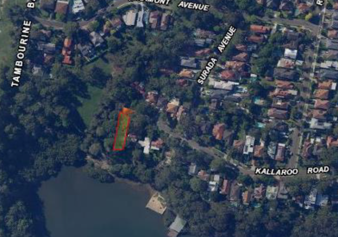
Figure 1: Aerial Photograph of Subject
Property
|
|
DA No:
|
DA18/2022
|
|
Date Lodged:
|
23 February 2022
|
|
Cost of Work:
|
$450,000.00
|
|
Owner:
|
CM & BA Beck
|
|
Applicant:
|
Daniel Sutton
|
|
Description of the proposal to appear on
determination
|
Alterations and additions to an existing
dwelling
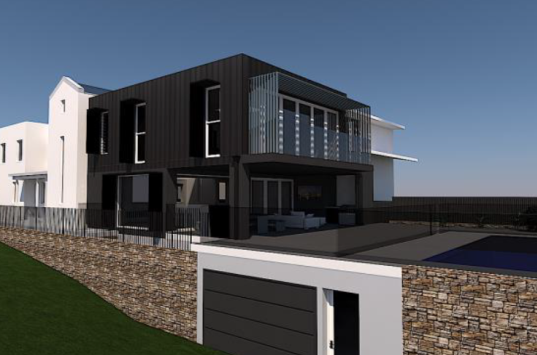
Figure 2: Perspective of Proposal
|
|
Zone
|
R2 Low Density
Residential under Lane Cove Local Environmental Plan (LCLEP) 2009
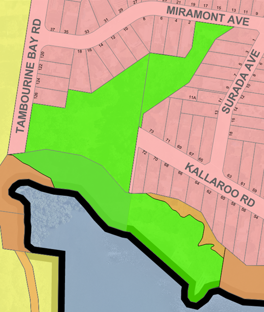
Figure 3: R2 Zoning of Subject Site
|
|
Is the proposal permissible within the
zone
|
Yes – a ‘dwelling
house’ development is permissible with consent within the R2 zone
|
|
Is the property a heritage item
|
No –
however the subject property adjoins Local Heritage Item I233, Tambourine Bay
Baths to the south.
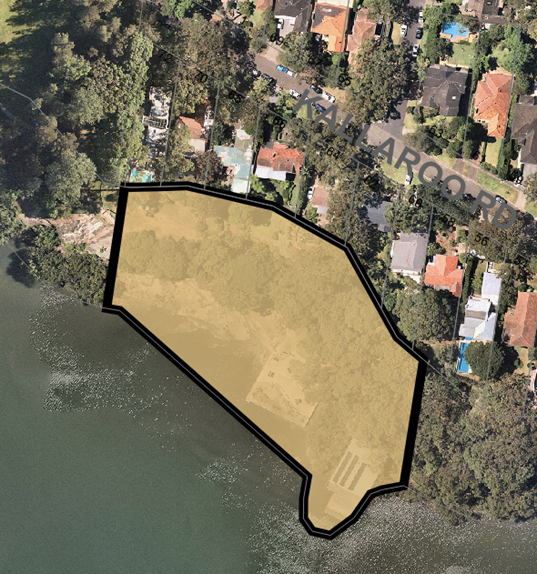
Figure 4: Adjoining Heritage Site
The
development proposal will not have any significant adverse impact upon the
heritage significance of this site.
|
|
Is the property within a conservation
area
|
No
|
|
Is the property adjacent to bushland
|
No
|
|
BCA Classification
|
Class 1a, 10a and 10b
|
|
Stop the Clock used
|
No
|
|
Notification
|
Notified in accordance with Council’s policy and no
objections
received
|
REASON FOR REFERRAL
The subject
Development Application is referred to the Lane Cove Local Planning Panel as
the applicant is proposing a maximum 16.9% breach to the Floor Space Ratio
(FSR) development standard under LCLEP 2009.
EXECUTIVE SUMMARY
The Development Application is
for alterations and additions to an existing dwelling.
The Development
Application has been assessed against LCLEP 2009 and is unsatisfactory as the
proposed FSR of 0.584:1 (a 16.9% variation) exceeds the prescribed
maximum floor space ratio of 0.5:1. It is considered that the submitted Clause
4.6 written request does not meet the relevant tests. The existing development
is already over the permitted maximum FSR development standard resulting from a
previous development consent and any further increases to this are not
supported. The proposal would be of such a scale that it would
be largely inconsistent with the controls set for this form of development
under the LEP.
Further, the
applicant has not adequately demonstrated full compliance with the maximum 9.5m
LEP Building Height development standard and the applicant has not submitted a
Clause 4.6 written justification claiming full compliance. Council’s
assessment has identified a maximum height of 9.7m and the breach cannot be
approved in this instance.
The Development
Application also has been assessed against Lane Cove Development Control Plan
(LCDCP) 2010 and there are variations identified which have been addressed
within this report.
The Development Application is reported to Panel
with a recommendation for refusal primarily due to the extent of the FSR
variation proposed where approval of the subject Development Application would
create an undesirable and dangerous precedent within the immediate Kallaroo
Road residential locality.
SITE
|
Property
|
Lot 124 DP 16472, No. 72 Kallaroo Road,
Riverview
|
|
Area
|
612m²
|
|
Site location
|
Southern side
of the Kallaroo Road at the western end of the road of the cul-de-sac
adjacent to Tambourine Park Reserve – see Figures 1 and 3 above
|
|
Existing improvements
|
Part two and
part three storey dwelling house with attached/detached garages and swimming
pool
Figure 5: Site Survey
Figure 6: Satellite Image of Subject Site
The existing
dwelling on the site contains:
Sub-Ground
Level
•
Existing basement/boat garage
•
Underground storage area (approved under Development Consent No 194/2015)
•
Internal stairs to ground level.
Ground
Level
•
Existing side front entrance with tiled covered entrance porch.
• Home office, guest bedroom,
bathroom, lounge and kitchen located in the front portion of the existing
dwelling.
•
Staircase to upper and lower levels.
•
Open plan lounge and dining room located at the rear of the
dwelling.
•
Outdoor covered alfresco entertaining area with built in BBQ and external WC.
First Floor
Level
• Bed 3, bed 2, bathroom, bed 4, bed
5, store/linen located in the front (northern) portion of the dwelling.
•
Stairs to lower level with voids either side and walk-bridge.
• Master suits with walk in robes and
ensuite at the rear (southern) end of the dwelling.
Front
Setback
•
Garage
•
Stone block front fencing.
•
Landscaped areas above garage and within front setback area.
•
Driveway along western side of the site to the rear of the property.
Rear
Setback
• Existing tiled rear POS area at
ground level adjoining covered external alfresco area.
• Swimming pool, tiled coping
with glass balustrades.
• Landscaped garden bed area to
the east of the swimming pool adjacent to the boundary.
The site
contains existing vegetation in the form of one tree within the front setback
of the site and small shrubs and other vegetation within the landscaped beds
within the front and rear setbacks. The site has a fall of approximately 3.9m
from the north (front) to the south (rear) and a cross fall of approximately
2.3m from the east to the west.
Figure 7: Subject Site Viewed from
Kallaroo Rd
Figure 8: Subject Site Looking South
Along the Western Boundary
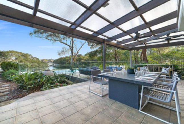
Figure 9: Rear Outdoor Alfresco Area
Looking South West

Figure 10: Rear of Subject Site Looking
North West
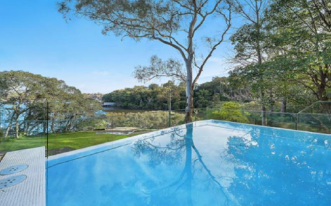
Figure 11: Looking South West Across
Existing Pool Towards Tambourine Reserve and Tambourine Bay
|
|
Shape
|
Irregular
|
|
Dimensions
|
Northern boundary (front – Kallaroo
Road): 13.285m
Eastern (side) boundary: 46.135m
Western (side) boundary: 52.725m
Southern (rear) boundary: 10.135m
|
|
Adjoining properties
|
Existing development
surrounding the site is primarily residential with one and two storey
residential dwellings. A specific description of surrounding development is
provided as below:
East – No. 70 Kallaroo Road which contains a twostorey rendered brick
dwelling with a tile roof
West –
Tambourine Bay Reserve which is a public reserve that
adjoins Tambourine Bay
North –
Across Kallaroo Road is No. 73 Kallaroo Road which
contains a two storey brick dwelling with a tile roof
South –
Tambourine Reserve which adjoins the southern
boundary of the subject site and further to the south is Tambourine Bay.
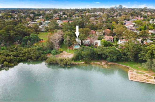
Figure 12: Aerial View of the Subject
Site Showing the Reserve and Tambourine Bay in the Foreground
|
PREVIOUS APPROVALS/HISTORY
|
DA351/2005
|
Approval for a
double garage with vehicular access from Council land issued on 22 February
2006
|
|
DA80/2013
|
Approval for a swimming pool issued on 27
May 2013
|
|
DA194/2015
|
Approval for
alterations and additions to the existing dwelling house including a part
basement addition to provide a media room and a workshop with an access
passageway issued on 27 April 2016.
|
PROPOSAL
|
The
proposal is for alterations and additions to an existing dwelling to include:
Ground Floor Level
• New hood above lounge room window
in the western external wall.
• New structural column in
south-western corner of the covered outdoor alfresco area.
• Render existing external walls.
First Floor
Level
•
Demolition of the western external wall of the master suite.
• Extend
the floor area toward the western boundary and construct new western external
wall.
• Retention of the eastern external wall of
the walk-in robe and ensuite and extend the eastern external wall to create
new ensuite.
• Recreate the floor plan to create new
master suite, large walk-in robe and dressing room and ensuite.
• Glass
bifold doors the full length of the southern external wall of the master
suite.
• Construct a new southern (rear) facing
balcony 1.245m wide accessed directly via the master suits, running the full
length of the master suite 6.4m in length.
•
Privacy screen to be installed on the eastern end of the new balcony
• New
hoods over the windows in the western wall.
• Skylights to roof over the alterations and
additions servicing the walk-in robe, dressing room, and master suite.
Materials of Construction
•
Lysaght ‘Klip-lok’ roofing.
• Render
existing masonry external walls in “Monument”.
•
‘Heka’ hoods over new windows to western external walls.
•
Snap-Lock to western external wall on first floor level in
“Monument”.
• New
privacy screen to first floor balcony in silver battens.
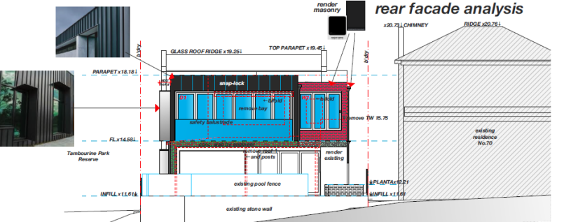
Figure 13: Proposed Rear Elevation
Figure 14: Proposed Side Elevations

Figure 15: Proposed Material and Finishes
The
justification of the proposed development is to improve the amenity of the
residents living at the subject site.
|
SECTION
4.15 ASSESSMENT
|
Any environmental planning instrument:
|
State
Environmental Planning Policy (SEPP) (Building Sustainability Index: BASIX)
2004
A valid BASIX certificate has been submitted with the application and confirms that the proposal (once
operational) will comply with the water, thermal comfort and energy efficiency
requirements of the policy.
State Environmental Planning Policy (SEPP) (Resilience and Hazards)
2021
On 1 March 2022, the provisions of SEPP (Resilience and
Hazards) 2021 had consolidated three state policies including SEPP 55 –
Remediation and SEPP (Coastal Management) 2018 into one policy. The provisions of the SEPP are required to be considered for any
development application to determine if the land:
· is suitable for the proposed development,
· if it is contaminated,
· if it is suitable for the proposed use, and
· if the contamination is required to be remediated before the land is
used for that purpose.
The site has
been developed from bushland into residential development over the years where
it is therefore unlikely that the site has any contamination, further as the proposed
development does not involve any excavation, no further investigation is
necessary for the proposed development.
The provisions
of the SEPP also apply to the proposed development as the site is within the
“proximity area for coastal wetlands” as shown by the figure below:
Figure 16: Proximity to Coastal Wetlands
The relevant clause reads
as:
2.8 Development
on land in proximity to coastal wetlands or littoral rainforest
Note—
The Coastal Wetlands and Littoral Rainforests Area Map identifies
certain land that is inside the coastal wetlands and littoral rainforests area
as “proximity area for coastal wetlands” or “proximity area
for littoral rainforest” or both.
(1) Development
consent must not be granted to development on land identified as
“proximity area for coastal wetlands” or “proximity area for
littoral rainforest” on the Coastal Wetlands and Littoral
Rainforests Area Map unless the consent authority is satisfied that the
proposed development will not significantly impact on—
(a) the biophysical, hydrological or ecological integrity of the adjacent
coastal wetland or littoral rainforest, or
(b) the quantity and quality of surface and ground water flows to and from the
adjacent coastal wetland or littoral rainforest.
(2) This
section does not apply to land that is identified as “coastal
wetlands” or “littoral rainforest” on the Coastal
Wetlands and Littoral Rainforests Area Map.
The proposed
development satisfies the provisions of the SEPP in that:
(a) The development proposes alterations and
additions to the existing dwelling where these alterations and additions are
confined to the first floor of the dwelling and are within the existing
building footprint. There will be no impacts upon the biophysical, hydrological
or ecological integrity of the adjacent coastal wetland or littoral rainforest.
(b) The development proposes additional roof area, of which the runoff
from the roof will connect to the existing stormwater infrastructure on the
site. The alterations and additions do not extend beyond the existing building
footprint of the dwelling or propose any additional hard paved surfaces at
ground level, excavation or the filling of soil on the site and in this regard
the development will not have any impact the quantity and quality of surface
and ground water flows to and from the adjacent coastal wetland or littoral
rainforest.
The proposed
development satisfies the provisions of the SEPP and no further consideration
is required in this instance.
State Environmental Planning Policy (SEPP) (Biodiversity and
Conservation) 2021
On 1 March 2022, the provisions of SEPP (Biodiversity and
Conservation) 2021 had consolidated 11 state and regional policies including
Sydney Regional Environment Plan (Sydney Harbour Catchment) 2005 into one
policy. The land is mapped as being within the Foreshores and Waterways
Boundary Area and a minor portion of the site is mapped as a Wetlands
Protection Area. An assessment has occurred against the relevant provisions of
the SEPP as illustrated in Attachment 1.
|
Clause
|
Provision
|
Proposal
|
Compliance
|
|
Chapter 10 Part 10.3 – Foreshore and Waterways Area
– Division 2 – Matters for Consideration
|
|
10.19 –
Biodiversity, ecology and environment protection
|
The
matters to be taken into consideration in relation to biodiversity, ecology
and environment protection are as follows—
(a) development should have a neutral or beneficial
effect on the quality of water entering the waterways,
(b) development should protect and enhance
terrestrial and aquatic species, populations and ecological communities and,
in particular, should avoid physical damage and shading of aquatic vegetation
(such as seagrass, saltmarsh and algal and mangrove communities),
(c) development should promote ecological
connectivity between neighbouring areas of aquatic vegetation (such as
seagrass, saltmarsh and algal and mangrove communities),
(d) development should avoid indirect impacts on
aquatic vegetation (such as changes to flow, current and wave action and
changes to water quality) as a result of increased access,
(e) development should protect and reinstate natural
intertidal foreshore areas, natural landforms and native vegetation,
(f) development should retain, rehabilitate and
restore riparian land,
(g) development on land adjoining wetlands should
maintain and enhance the ecological integrity of the wetlands and, where
possible, should provide a vegetative buffer to protect the wetlands,
(h) the cumulative environmental impact of
development,
(i) whether sediments in the waterway adjacent to the
development are contaminated, and what means will minimise their disturbance.
|
The
proposal does not provide for excessive water flows to stormwater pits which
are piped to Lane Cove River and has been assessed to be satisfactory by
Council’s stormwater engineer.
The proposed overshadowing
is satisfactory
The proposal does not
include works impacting upon the connectivity of aquatic vegetation.
The proposal does not
modify existing foreshore access.
The proposal does not
include works encroaching the foreshore area with no vegetation impacts.
The foreshore area on the
subject site is not mapped as riparian land.
The proposal would not
adversely impact the vegetative buffer through the appropriate stormwater
infrastructure.
As
above.
No known contamination.
|
Yes
|
|
10.20 – Public
access to, and use of, foreshores and waterways
|
The
matters to be taken into consideration in relation to public access to, and
use of, the foreshores and waterways are as follows—
(a) development should maintain and improve public
access to and along the foreshore, without adversely impacting on
watercourses, wetlands, riparian lands or remnant vegetation,
(b) development should maintain and improve public
access to and from the waterways for recreational purposes (such as swimming,
fishing and boating), without adversely impacting on watercourses, wetlands,
riparian lands or remnant vegetation,
(c) if foreshore land made available for public
access is not in public ownership, development should provide appropriate
tenure and management mechanisms to safeguard public access to, and public
use of, that land,
(d) the undesirability of boardwalks as a means of
access across or along land below the mean high water mark if adequate alternative
public access can otherwise be provided,
(e) the need to minimise disturbance of contaminated
sediments.
|
The
proposal would not impact upon foreshore use or access.
|
Yes
|
|
10.21
– Maintenance of a working harbour
|
The
matters to be taken into consideration in relation to the maintenance of a
working harbour are as follows—
(a) foreshore sites should be retained so as to
preserve the character and functions of a working harbour, in relation to
both current and future demand,
(b) consideration should be given to integrating
facilities for maritime activities in any development,
(c) in the case of development on land that adjoins
land used for industrial and commercial maritime purposes, development should
be compatible with the use of the adjoining land for those purposes,
(d) in the case of development for industrial and
commercial maritime purposes, development should provide and maintain public
access to and along the foreshore where such access does not interfere with
the use of the land for those purposes.
|
The proposal would not
impact upon the maintenance of a working harbour.
|
Yes
|
|
10.22 –
Interrelationship of waterway and foreshore uses
|
The
matters to be taken into consideration in relation to the interrelationship
of waterway and foreshore uses are as follows—
(a) development should promote equitable use of the
waterway, including use by passive recreation craft,
(b) development on foreshore land should minimise any
adverse impact on the use of the waterway, including the use of the waterway
for commercial and recreational uses,
(c) development on foreshore land should minimise
excessive congestion of traffic in the waterways or along the foreshore,
(d) water-dependent land uses should have priority
over other uses,
(e) development should avoid conflict between the
various uses in the waterways and along the foreshores.
|
The proposal does not
adversely impact upon the intended interrelationship of waterway and
foreshore uses as intended by this clause.
|
Yes
|
|
10.23 – Foreshore
and waterways scenic quality
|
The
matters to be taken into consideration in relation to the maintenance,
protection and enhancement of the scenic quality of foreshores and waterways
are as follows—
(a) the scale, form, design and siting of any
building should be based on an analysis of—
(i) the land on which it is to be erected, and
(ii) the adjoining land, and
(iii) the likely future character of the locality,
(b) development should maintain, protect and enhance
the unique visual qualities of Sydney Harbour and its islands, foreshores and
tributaries,
(c) the cumulative impact of water-based development
should not detract from the character of the waterways and adjoining
foreshores.
|
The scale of the building
is excessive as detailed in this report.
The visual quality may be
reduced from the waterways due to the uncharacteristic bulk to be created by
the proposed development. It is noted that no visual analysis from the water
is provided by the applicant.
N/A
|
Not
demonstrated.
Not
demonstrated.
N/A
|
|
10.24 –
Maintenance, protection and enhancement of views
|
The
matters to be taken into consideration in relation to the maintenance,
protection and enhancement of views are as follows—
(a) development should maintain, protect and enhance
views (including night views) to and from Sydney Harbour,
(b) development should minimise any adverse impacts
on views and vistas to and from public places, landmarks and heritage items,
(c) the cumulative impact of development on views should
be minimised.
|
No significant loss of
views to (if any) and from Sydney Harbour has occurred.
View loss impacts minimised
where possible
Noted.
|
Yes
Yes
|
|
10.25 – 10.27
– Boat storage facilities, Floating boat platforms, Mooring pens
|
Not
Applicable
|
Not
Applicable
|
N/A
|
|
Part 10.6 – Wetlands Protection
|
|
Clause
10. 63 – Matters for consideration
|
(1) The
matters referred to in this clause (together with any other relevant
matters)—
(a) are to be taken into consideration by consent
authorities before granting consent to development under Part 4 of the Act,
and
(b) are to be taken into consideration by public
authorities and others before they carry out activities to which Part 5 of
the Act applies.
(2) The matters to be taken into consideration in relation
to any development are as follows—
(a) the development should have a neutral or
beneficial effect on the quality of water entering the waterways,
(b) the environmental effects of the development,
including effects on—
(i) the growth of native plant communities,
(ii) the survival of native wildlife populations,
(iii) the provision and quality of habitats for both
indigenous and migratory species,
(iv) the surface and groundwater characteristics of
the site on which the development is proposed to be carried out and of the
surrounding areas, including salinity and water quality and whether the
wetland ecosystems are groundwater dependent,
(c) whether adequate safeguards and rehabilitation
measures have been, or will be, made to protect the environment,
(d) whether carrying out the development would be
consistent with the principles set out in The NSW Wetlands Management
Policy (as published in March 1996 by the then Department of Land
and Water Conservation),
(e) whether the development adequately preserves and
enhances local native vegetation,
(f) whether the development application adequately
demonstrates—
(i) how the direct and indirect impacts of the
development will preserve and enhance wetlands, and
(ii) how the development will preserve and enhance
the continuity and integrity of the wetlands, and
(iii) how soil erosion and siltation will be
minimised both while the development is being carried out and after it is
completed, and
(iv) how appropriate on-site measures are to be
implemented to ensure that the intertidal zone is kept free from pollutants
arising from the development, and
(v) that the nutrient levels in the wetlands do not
increase as a consequence of the development, and
(vi) that stands of vegetation (both terrestrial and
aquatic) are protected or rehabilitated, and
(vii) that the development minimises physical damage
to aquatic ecological communities, and
(viii) that the development does not cause physical
damage to aquatic ecological communities,
(g) whether conditions should be imposed on the
carrying out of the development requiring the carrying out of works to
preserve or enhance the value of any surrounding wetlands.
|
Relevant matters are
addressed as there would be no significant impacts onto adjoining wetland
areas subject to appropriate conditions should the proposal be approved
|
Yes
|
Lane Cove Local Environmental Plan 2009
Permissibility
The land is zoned R2 Low Density
Residential under Lane Cove Local Environmental Plan 2009 (see Figure 3 above
in this report). The proposal is for alterations and additions to an existing
dwelling house and dwelling houses are permissible with consent under the LEP.
Aims and Zone Objectives
The subject site
is zoned R2 Low Density Residential and the immediate locality is zoned R2. To
be discussed in further detail in this report below, the proposed additional
floor space created would contain adverse local character or amenity impacts
which does not satisfy the following Lane Cove LEP 2009 aim and zoning
objective as follows:
· to preserve and, where appropriate, improve the
existing character, amenity and environmental quality of the land to which this
Plan applies in accordance with the indicated expectations of the community.
· To retain, and where appropriate improve, the
existing residential amenity of a detached single family dwelling area.
It is considered
that the location of the new floor space is not suitable where it would be
inconsistent with the intended built form of the local R2 zoned catchment.
Approval of the proposal would not assist in maintaining or improving current
local amenity levels which are enjoyed by surrounding residents. The location
of the spa would also be obtrusive when viewed from an adjoining property to
the east.
Development Standards
The land is mapped on the Height
of Buildings Map and Floor Space Ratio Map under Lane Cove Local Environmental
Plan 2009. An assessment of the proposal against the building height and floor
space development standard is provided in the table below.
|
Lane
Cove Local Environmental Plan 2009 – Development Standard Compliance
|
|
Standard
|
Mapped Maximum
|
Proposed Maximum
|
Compliance
|
|
Floor
Space Rati
|
0.5:1
(306sqm permitted)
|
Applicant Assessment:
0.584:1 (358sqm proposed, a 16.9% variation)
Council Assessment: 0.584:1
+ additional areas within basement that ought to be counted as GFA
|
No,
Clause 4.6 unsatisfactory - see below.
|
|
Building
Height
|
9.5m
|
Applicant Assessment: Max.
9.5m
Council Assessment: Max.
9.7m
|
No, not demonstrated and
no Clause 4.6 submitted – recommended as a reason for refusal.
|
Clause 4.6 Written Request – Floor Space Ratio
A maximum FSR of 0.5:1 applies to
the site under LCLEP 2009.
Figure 17: LEP FSR Map (0.5:1 hatched in blue)
The proposal has a maximum FSR of
0.584:1 (a 16.9% variation) where a maximum of floorspace of
306m² is permitted and a maximum floor space
proposed is 358m² (being 52m² over). The site has had previous application determinations made, most
recently is Development Consent No. 194/2015 which was for alterations and additions
to the existing dwelling including basement extension to
provide a media room and a workshop with an access passageway approved by Council on 27 April 2016 under Delegated Authority. The
applicant has stated that this application was approved with an FSR of 0.524:1
or 320.8m² which exceeded
the maximum FSR of 0.5:1 under Clause 4.4 of LCLEP 2009.
The proposed
alterations and additions which are the subject of this application seeks to
further increase the floor space of the dwelling by 36.97m² to enable necessary changes to be
made to the existing first floor plan in the rear half of the dwelling to
improve the amenity of the master suite, ensuite and walk in robe/dressing
room. A review of the approved delegated report has indicated that the approved
FSR was 0.58:1 (355m²) which would mean that the
proposed FSR would be at least approximately 0.64:1 as Council had counted
parts of the basement level as floor space in addition the floorspace created
by the media room. However, if one counted all the applicant’s excluded
areas, the maximum FSR would be approximately 0.69:1 Please see the
applicant’s method of calculation below:
Figure 18: Applicant’s FSR Calculation Diagrams
The relevant GFA definition reads
as follows:
gross floor area means the sum of the floor area of each floor of a
building measured from the internal face of external walls, or from the
internal face of walls separating the building from any other building,
measured at a height of 1.4 metres above the floor, and includes—
(a) the area of a mezzanine, and
(b) habitable rooms in a basement or an attic, and
(c) any shop, auditorium, cinema, and the like, in a basement or
attic,
but excludes—
(d) any area for common vertical circulation, such as lifts and
stairs, and
(e) any basement—
(i) storage, and
(ii) vehicular access, loading areas, garbage and services, and
(f) plant rooms, lift towers and other areas used exclusively for
mechanical services or ducting, and
(g) car parking to meet any requirements of the consent authority
(including access to that car parking), and
(h) any
space used for the loading or unloading of goods (including access to it), and
(i) terraces and balconies with outer walls less than 1.4 metres
high, and
(j) voids above a floor at the level of a storey or storey above.
The areas not counted as floor
space by the applicant ought to be counted as GFA as there is another double
garage structure located at the front of the subject site which is not counted
as floor space and any additional garaging floor space is technically required
to be counted. It is considered that boat store and a workshop is not typical
‘storage’ space as defined by the LEP which would be excluded as
floor space under the LEP definition of GFA as boat storage is not storage as
such where it is used for parking purposed whether it is for a boat or for
vehicles. The basement level is not a basement as such as it would now contain
a media room and garaging space with a potential for a workshop as it was
included under the previous development consent.
Further, the hallway would also
need to be included as floor space as well as it would not be access to car
parking to meet the parking requirements of Council. It is considered that
there are excessive floor areas excluded that ought to be included.
Clause 4.6 Exceptions to
development standards
Clause 4.6 of LCLEP 2009 allows
exceptions to development standards. Consent must not be granted for
development that contravenes a development standard unless the consent
authority has considered and agrees with the written request from the applicant
that seeks to justify the contravention of the development standard. This
written request must demonstrate compliance with the relevant provisions of
Clause 4.6 of LCLEP 2009. These matters are discussed below:
Written request provided by
the applicant
The applicant has provided a
written request seeking a variation to the development standard with the lodged
application. A copy of the request is provided to the Panel (see Attachment 2).
Under Clause 4.6(3) the applicant is required to demonstrate:
(a) that compliance with the development standard is
unreasonable or unnecessary in the circumstances of the case, and
(b) that there are sufficient environmental
planning grounds to justify contravening the development standard.
1. Whether compliance with the
development standard would be unreasonable or unnecessary in the circumstances
of the case.
The Clause 4.6 variation has
argued that it is unreasonable or unnecessary for the same reasons provided
under the building height development standard to require strict compliance
with the development standard however provided the additional following
reasons:
Compliance with the development standard is unreasonable and
unnecessary as the subject site has an existing non-compliance of 0.524:1
approved under Development Consent 194/2015. The additional GFA proposed under
this application is to provide necessary improvements to the layout of the rear
of the first-floor master bedroom, walk in robe and ensuite. There are no
unreasonable environmental amenity impacts in terms of bulk and scale impacts,
overshadowing, loss of views, privacy or visual amenity of the development.
Comment:
The Clause 4.6
written request does not demonstrate that compliance with the development
standard would be unreasonable or unnecessary and accordingly does not satisfy
Clause 4.6(3)(a) of Lane Cove Local Environmental Plan 2009.
2. Environmental planning grounds to justifying contravening the
development standard.
The applicant has provided the following additional environmental
planning grounds justifications:
Strict technical compliance with the FSR development standard cannot
be achieved due to the existing FSR non-compliance approved under DA 194/2015.
• The
additional GFA proposed under this application is 36.97sqm and is required to
make necessary improvements to the layout of the existing master suite, walk in
robe, and ensuite at the rear of the first floor which will increase the
quality of living for the current occupants of the dwelling.
• The
proposed development achieves compliance with the relevant underlying
objectives of the standard and of the zone as discussed in this submission.
• The
proposal does not result in any adverse impacts upon adjoining properties by
way of bulk, scale, privacy, noise or overshadowing impacts.
• The
proposal does not create any view loss to adjoining properties or from any
public space.
• The
proposal will provide a suitable design and of suitable amenity in terms of the
built environment which is identified as objects of the Act (Section 1.3 of the
EP & A Act, 1979).
• The
intensity of the development is appropriate and acceptable, having regard to
existing development and adjoining/surrounding development.
The
environmental planning grounds are not supported as the proposal does not
comply with both the LEP building height 9.5m contrary to the claim of
compliance and LCDCP wall height control of 7m (9.7m above natural ground level
which now includes the ‘basement’ level) whilst claiming a maximum
wall height of 7.7m. The applicant has not demonstrated compliance with the
relevant height controls partly by not correctly nominating what the natural
ground levels are across the subject site and on the submitted plans. The
controls seek to establish an appropriate wall height for flat roof dwellings
to mitigate the impacts of bulk and scale.
Overall, the
environmental planning grounds put forward in the Clause 4.6 written request
are not considered to satisfy Clause 4.6(3)(b) of Lane Cove Local Environmental
Plan 2009.
3. Consistent
with the zone objectives and objectives of the development standard.
Development consent cannot be granted
to vary a development standard unless a consent authority is satisfied that the
proposed development would be in the public interest because it is consistent
with the objectives of the standard and the objectives for development within
the zone in which the development is proposed to be carried out.
The applicant has stated that:
The proposal achieves the relevant
objective of the FSR development standard as it is compatible with the character of the locality. Surrounding
development is primarily residential in nature and consists mainly of two
storey dwellings. The subject site is adjacent to a nature reserve and the
waterfront, and the proposed additions do not create any visual impacts to or
from the reserve or waterfront. The rear additions to the first floor of the
dwelling have been carefully designed so that the materials and finishes are
complimentary to the setting of the development, and the development is fully
compliant with the maximum height of building development standard.
An assessment against the objectives
of FSR and the IN2 Light Industrial zone contained within LCLEP 2009 are
provided as follows:
FSR
Objective
Clause 4.4(1) provides the following objective:-
(a) to ensure that the bulk and scale of development is
compatible with the character of the locality.
Comment:
The additional floor space proposed to
be created would contribute to the unnecessary bulk and
scale to the overall building and in turn would adversely affect the character
of the immediate Kallaroo Road/Riverview locality by not providing for a good
planning outcome where it would set a dangerous or an undesirable precedent.
The existing dwelling already has an FSR which is above the maximum FSR
development standard and any further increases are not supported in this
instance.
In accordance
with the above, it is contended that the development does not comply with the
LCLEP 2009 objective of the FSR control and is not supported in this instance.
R2 Low Density Residential
Zone Objectives
The applicant has provided the
following justifications as to why the proposed development is consistent with
the R2 zone objectives as follows:
The proposal
accommodates sufficient indoor living space and private open space to serve the
housing needs of a typical family, in accordance with community standards and
within a low-density residential environment. The proposal seeks to improve
upon the existing residential amenity of a detached single-family dwelling. The
proposed additions to the first-floor level which are the subject of the GFA
variation are necessary to improve the functionality of the rear of the
first-floor plan, including the master suite, walk in robe and ensuite area.
The proposed
rear addition will be visible from the waterfront, however as they are located
to the rear of the existing dwelling and are contained within the overall
building envelope, i.e., do not increase the overall building height or change
the existing building setbacks to side boundaries, there is a negligible impact
to the visibility of the additions when viewed from the waterfront. The
proposal seeks to improve upon the current degree of landscaped area on the
site despite there being no requirement for this due to the proposed building
works being confined to the rear of the first floor of the dwelling. The
development proposes an additional 13.5sqm of landscaped area within the front
setback of the site in the form of a landscaped garden bed.
As
demonstrated above, the proposed development will be in the public interest
because it is consistent with the objectives of the FSR development standard
and the objectives of the R2 Zone.
The R2 Low Density Residential Zone
objectives are as follows:
· To provide for the housing
needs of the community within a low density residential environment.
Comment: The proposed FSR of the development would not be
commensurate with the low-density residential environment in which it is
proposed to be situated and is resultant from a development form not intended
for lots of this size.
· To enable other land uses that
provide facilities or services to meet the day to day needs of residents.
Comment: N/A
· To retain, and where
appropriate improve, the existing residential amenity of a detached single
family dwelling area.
Comment: The proposed bulk and scale is considered to reduce the residential
amenity of a detached single-family area through providing a dwelling design
that is larger than anticipated and over-bearing.
· To encourage new dwelling
houses or extensions of existing dwelling houses that are not highly visible
when viewed from the Lane Cove River or Parramatta River.
Comment: Not satisfactorily demonstrated by the applicant.
· To ensure that landscaping is
maintained and enhanced as a major element in the residential environment.
Comment: Landscaping is not adversely impacted by the proposed development.
In accordance
with the above, the development does not comply with the Lane Cove Local
Environmental Plan 2009 objectives for the Floor Space Ratio standard or the R2
Low Density Residential zone and is therefore not in the public interest.
4. Concurrence of the Director
General.
The Local Planning Panel can
assume concurrence for exceptions to development standards where the variation
to the development standard is greater than 10%. As the proposal is
referred to the Local Planning Panel for determination; concurrence is taken to
be assumed.
5. Conclusion
The
objectives of Clause 4.6 are to provide an appropriate degree of flexibility in
applying certain development standards and to achieve better outcomes for and
from development by allowing flexibility in particular circumstances. The
variation to the height standard of LCLEP 2009 is not well-justified in this
instance. There are insufficient environmental planning grounds and the
objectives of the standard are not met. The
development does not satisfy the objectives and the criteria outlined in clause
4.6. As such, the variation is not considered satisfactory or in the public
interest.
Building Height
The submitted architectural
drawings does not adequately demonstrated whether the proposal complies with
the maximum 9.5m Building Height development standard by not indicating where
the natural ground levels and the maximum building height plane are. The
drawings have been reviewed with respect to the definition of Building Height
contained within Lane Cove Local Environmental Plan 2009 being:
building height (or height of building) means—
(a) in relation to the height of a building in metres—the
vertical distance from ground level (existing) to the highest point of the
building, or
(b) in relation to the RL of a building—the vertical distance
from the Australian Height Datum to the highest point of the building,
including plant and lift overruns, but excluding
communication devices, antennae, satellite dishes, masts, flagpoles, chimneys,
flues and the like.
Whilst the applicant has claimed
full compliance however Council’s assessment has indicated that when you
measure the highest point of the proposed addition from top of the parapet to
the bottom of the basement level which is now the natural ground level, the
maximum height is proposed is 9.7m when measuring off the submitted section
plans.
Figures 19 & 20: Relevant Section Indicating a
Maximum 9.7m Building Height from Top of Parapet (Coloured in Red) to the
Bottom of the Basement Level
As there is no submission of a
Clause 4.6 written justification by the applicant, the proposed breach to
building height cannot be approved in this instance and along with the proposed
extent of the FSR variation, the subject Development Application is recommended
to be refused despite the proposed height breach of the
dwelling house being minimal with the applicant merely attempting to match the
existing parapet roof line of the existing dwelling. It is noted that it would
also appear to be below the existing height of the glass void/clerestory roof
ridge structure in the middle section of the building.
Other Considerations
|
Lane Cove Local Environmental Plan 2009 – Other Relevant
Provisions
|
|
Provision
|
Assessment
|
|
Clause 5.10(5) - Heritage Conservation
|
The
proposal is subject to Clause 5.10 of LCLEP 2009 due to the land being
adjacent to a local heritage item to the south (I233 - Tambourine Bay Baths, see Figure 4). Clause 5.10(5) states the following:
(5) Heritage assessment The
consent authority may, before granting consent to any development—
(a) on land on which a
heritage item is located, or
(b) on land that is within a
heritage conservation area, or
(c) on land that is within
the vicinity of land referred to in paragraph (a) or (b), require a heritage
management document to be prepared that assesses the extent to which the
carrying out of the proposed development would affect the heritage
significance of the heritage item or heritage conservation area concerned.
Council’s
Heritage Advisor has reviewed the proposal and has concluded that the development as proposed would not
have an unacceptable impact on the item. Accordingly, the proposal is
considered to satisfy Clause 5.10(5) of LCLEP 2009.
|
|
Any proposed instrument
(Draft LEP, Planning Proposal)
|
N/A
|
Any development control plan
|
Lane Cove DCP
2010
Parts B
and C1 – General Controls, Dwelling Houses and Dual Occupancies
A full
assessment of the proposal under LCDCP 2010 Parts B and C1 has occurred and the
non-compliances identified in the table are assessed below.
|
LCDCP 2010 -
Dwelling House – Table of Compliance
|
|
Part
|
Control
|
Proposed
|
Complies
|
|
Front setback
(min)
|
Consistent with
area or 7.5m
|
There are no
changes to the existing front setback
|
N/A - existing
|
|
Side setback
(min)
|
1200mm single
storey
1500mm two
storey
|
The first floor
of the existing dwelling has setbacks as follows: Eastern: 1.145m Western:
1.125m
The proposed
alterations and additions to the rear existing first floor of the dwelling
proposes the following side setbacks:
Eastern: 1.145
– following on from existing building line. Western: 1.615m
|
No, whilst
extension of wall is consistent with existing building setbacks however would
contribute to the unnecessary overall increased bulk or scale of the
development
|
|
Rear setback
(min)
|
<1000m²:
8m or 25% whichever is the greater. The subject site has an irregular shape the eastern boundary measures
46.135m and the western boundary measures 52.725m where the average is 49.43m
Setback
required: 12.4m
|
The proposed
alterations and rear addition to the first floor have a rear setback of
8.675m on the eastern boundary and 10.475m on the western boundary.
|
No, the rear
setbacks would be inconsistent with the rear setback of the adjoining
property
|
|
Wall Height
(max) (max parapet of 600mm)
|
7.0m
|
9.7m –
flat roof parapet design
|
No, see
Building Height discussion in the main report
|
|
Maximum Ridge
height
|
9.5m
|
See above
|
No, not
adequately addressed by the applicant
|
|
Undercroft
height (max)
|
1m
|
No change to
existing
|
N/A - existing
|
|
Number of
Storeys (max)
|
2
|
Part 2 and 3
|
Existing
variation however the extent of the 3 storey component of the development has
been increased by the subject proposal
|
|
Maximum Number
of Storeys in Elevation Profile
|
3
|
3 along the
western and rear elevations
|
Yes
|
|
Landscaped area
(min) (Minimum width of 1m required to be included in area)
|
35%
The site has an
area of
612sqm and therefore is required to have 35% or 214.2sqm landscaped area.
|
143.35sqm being
an increase of 13.5sqm (23.4%)
|
Existing
landscaped area maintained however it is an indicator of the already
overdeveloped nature of the site
|
|
Foreshore Building Line (min)
|
See DCP for details
|
The proposal does not pass the 1st test where the new first-floor
level setback would not match the first-floor level of the adjoining dwelling
to the east
|
No, the
variation along with the other variations proposed would adversely contribute
to the relevant bulk and scale concerns raised
|
|
Cut and Fill (max)
|
1m
|
No cut and fill
proposed
|
Yes
|
|
Solar Access
|
3 hrs as per
DCP.
|
Achieved
|
Yes
|
|
Provide for view
sharing
|
See DCP for
details
|
Further
encroachments to the rear may affect some existing views to the Tambourine
Bay Bushland Reserve from the adjoining to the east
|
Whilst not a
reason for refusal as the majority of views would be maintain however the
additional works does contribute to the overdeveloped nature of the proposal
|
|
Heritage
Conservation
|
See heritage
referral assessment.
|
See heritage
referral assessment.
|
Yes
|
|
Deck/Balcony
depth (max)
|
3m
|
Max. 1.25m
|
Yes
|
|
Rooftop Terraces
|
No rooftop
terraces allowed.
|
None proposed
|
N/A
|
|
Private open
space
|
24 m² (min)
4m minimum depth
|
Achieved
|
Yes
|
|
Off-street
spaces (min)
|
2
|
Achieved
|
Yes
|
|
Driveway width
|
3m at the lot
boundary
|
Consistent with
existing.
|
N/A
|
|
% of Allotment Width (garages & carports)
|
50% of lot width or 6m, whichever is the lesser
|
Unchanged -
existing
|
N/A
|
|
Pool Setback to Neighbour’s House (min)
|
3m to waterline
|
Unchanged - existing
|
N/A
|
|
Pool Height (max)
(steeply sloping sites)
|
1.0m
1.8m
|
Existing
|
N/A
|
|
Pool Setback from boundary if coping is above ground level (existing)
(min)
|
Coping to be set back at a ratio of 1:1
|
Existing
|
N/A
|
|
Front fence
height (max)
|
Solid: 900mm
Lightweight: 1.2m
|
Existing
|
N/A
|
|
Front fence
setback from front boundary if > 1.2m
|
1m
|
Existing
|
N/A
|
|
Side and rear
fences
|
1.8m
|
Not proposed.
|
N/A
|
DCP Objectives
The relevant objectives for dwelling houses
and dual occupancies are as follows:
Clause 1.1
· Ensure new dwellings and alterations & additions to existing
dwellings are well designed and compatible with the surrounding context and
enhance the streetscape within the area.
· Achieve a reasonable level of amenity for both development sites and
neighbouring dwellings.
Variations
The following section of the
report addresses the proposed variations to the prescriptive DCP measures
sought to be varied having regard to the applicant’s submitted
justification and the objectives of the prescriptive measure sought to be
varied:
The relevant DCP setbacks objective is as follows:
Clause 1.3
· Side and rear setbacks are to provide building separation, sunlight,
landscaping, ventilation, public views (if appropriate) for the dwelling and
its neighbours.
i. Side First Floor Setback
– The DCP required a minimum 1.5m setback on the first-floor level.
The existing first floor setbacks are a minimum of 1.145m to the eastern
boundary and 1.125m to the western boundary. It is proposed to have minimum
setbacks of 1.145m to the eastern boundary to match the existing setback and
1.615m to the western boundary. Whilst not a reason to refuse in
isolation, the proposed variation along with the other proposed variations
including the proposed large variation to FSR cumulatively contribute to the unnecessary
created bulk or scale of the development in particular to the adjoining
dwelling to the east by further minimising building separation and public
views.
ii. Rear Setback – The
DCP requires a minimum 12.4m rear setback. The proposed
alterations and rear addition to the first floor would have a rear setback of
8.675m on the eastern boundary and 10.475m on the western boundary. It is noted that
the existing rear setback of both the ground and first floors matches the
existing setbacks of the dwelling to the east and the proposed upper level
addition including new balconies would now be well forward of the existing
ground level deck and well forward of the upper level including the balcony of
the adjoining dwelling.
Figure 21: Proposed Roof Plan of the New Works
Adjacent to the Existing Adjoining Dwelling
Along with the above side first
floor setback variation, this variation also contributes to the concerns posed
by the large FSR variation involved being the overdeveloped nature of the
proposal by not maintaining a consistent rear setback with the adjoining
dwelling and reasons provided above under the side setback variation section of
this report.
The relevant DCP building design objectives are as follows:
Clause 1.7
· Ensure new dwellings and alterations and additions to existing
dwellings reinforce the typical bulk and scale of existing dwellings within the
street and the area.
· Ensure elevations to the street and public domain are well
proportioned and designed.
· Minimise impact in terms of overshadowing, loss of privacy, light
spillage to adjoining properties, loss of views and amenity.
iii. Wall Height – The
DCP stipulates a maximum wall height of 7.0m where a wall height of 9.7m
inclusive of the proposed parapet structure on a flat roofed design, which had
not been addressed by the applicant (see the Building Height section above in
this report for further details) claiming full compliance. Again, the proposed
extension with this proposed breach would contain some additional unnecessary
bulk and scale issues which could be easily addressed with a minor redesign to
fully comply and to minimise impacts on the adjoining property.
The relevant DCP B5 Development in Foreshore Areas objective
is as follows:
Clause 5.1
· Maintain or enhance existing residential amenity and visual
character of foreshore residential development by:
- i. Minimising the impact
and prominence of foreshore development when viewed from the Lane Cove and
Parramatta Rivers.
ii. Ensuring that
the architecture of development that is highly visible from the rivers is not
visually prominent, in character with the locality and minimises its bulk and
scale.
iv. Foreshore Building Line
(1st Test) – As a guide only, the DCP requires that the foreshore
setback line is to be kept parallel to the foreshore where there is only one
neighbour. The proposal does not demonstrate technical compliance with the
second test being that the proposed upper level extension does not match the
existing upper levels of the adjoining dwelling as discussed in this report and
as shown under Figure 21 above. It is considered that the
proposal’s inconsistency with the adjoining dwelling upper level setbacks
would also contribute to the additional potential adverse impacts resulting
from the substantial FSR and rear building setback variations being
proposed.
|
The likely impacts of that
development, including environmental impacts on both the natural and built
environments, and social and economic impacts in
the locality
|
The impacts on both the natural
and built environments of the locality have been considered and addressed in
the report and are unsatisfactory.
|
The suitability of the site for the
development
|
The proposed
development does not respond appropriately to the site constraints and
therefore the site is not suitable for the development in this instance.
|
Any submissions made in accordance
with this Act or the regulations
|
The proposed development was
notified in accordance with Council policy and one submission was received from
the adjoining dwelling to the east at No. 70 Kallaroo Road. The submissions
main points are summarised and addressed below.
This is a substantial extension
from the existing upper level footprint. Although there is a privacy screen,
there still would be adverse privacy impacts into the adjoining property. The
extensions would impact the views to Tambourine Bay Bushland Reserve. The
proposed extension is based on further increasing on the permitted land to
building ratio permitted which is already over from the recent approval granted
for the basement media room under the house.
Comment: The proposed
increase in floor space would further add to the already existing
non-compliance with Council’s maximum 0.5:1 FSR development standard and
no further increases in floor space proposed on the subject site ought to be
approved in this instance. It is considered that the maximum development
potential or yield on the site has been fully achieved and approval would
create a precedent for the immediate Kallaroo Road locality where there have
been no substantial variations approved. It is recommended that the subject
application be refused to maintain the existing residential amenity to be
maintained in particular to the adjoining property to the east.
The proposal would be contrary to the public
interest if approved as it provides for an overdevelopment of a residential
site that departs from the envisaged/existing built form of the low-density
residential character of the immediate Kallaroo Road locality and its potential
adverse impacts to an adjoining property.
CONCLUSION
The matters in
relation to Section 4.15 of the Environmental Planning and Assessment Act 1979
have been addressed in the report. The Development Application is for
alterations and additions to an existing part two and part three storey
dwelling house. The proposed development is of such a bulk and scale that it is
largely inconsistent with the controls set for this form of development under
Lane Cove Local Environmental Plan 2009 and Lane Cove Development Control Plan
2010. The FSR variation of 16.9% is demonstrative of this. The resulting
impacts on the locality and on an adjoining property are considered
unsatisfactory. The Development Application
is reported to the Lane Cove Local Planning Panel with a recommendation for
refusal for the reasons outlined below.
|
RECOMMENDATION
That the Lane Cove Local Planning Panel
refuse a variation to the floor space ratio prescribed by Clause 4.4 of the
Lane Cove Local Environmental Plan 2009, as it is not satisfied that the
applicant’s request has adequately addressed the matters required to be
demonstrated by Clause 4.6 of that Plan, and the proposed development would
be contrary to the public interest as it is inconsistent with the objectives
of that particular standard and the objectives for development within the
zone.
That pursuant to Section 4.16(1)(b) of the Environmental Planning
and Assessment Act, 1979 the Lane Cove Local Planning Panel at its meeting of
15 June 2022, exercising the functions of Council as the consent authority,
refuse Development Application DA18/2022 for the alterations and additions to
an existing dwelling at No. 72 Kallaroo Road, Greenwich for the following
reasons:
1. Aims of Lane Cove
Local Environmental Plan 2009:
The
proposed development does not meet the aims of Lane Cove Local Environmental
Plan 2009.
Particulars:
a) The proposed development would not
preserve and improve the existing character, amenity and environmental
quality of the land and the expectations of the community.
2. Objectives of Lane
Cove Local Environmental Plan 2009:
The proposed development does not meet the objectives of the Zone R2 Low
Density Residential of the Lane Cove Local Environmental Plan 2009.
Particulars:
a) To
retain, and where appropriate improve, the existing residential amenity of a
detached single family dwelling area.
3. Floor
Space Ratio
The proposed
floor space ratio exceeds the standard and the Clause 4.6 written request is unsatisfactory.
Particulars
a) Clause 4.4 of LCLEP applies a maximum floor space
ratio of 0.5:1 to the land.
b) The proposed floor space ratio is 0.584:1 being a
variation of 16.9%.
c) The calculation should likely include additional
areas within the basement level.
d) The Clause 4.6 written request is considered
unsatisfactory as it does not demonstrate the matters to be established under
Clause 4.6(3).
e) Approval of the floor space ratio variation would be
contrary to the public interest as it does not comply with the objectives of
the standard or zone.
4. Building Height
The proposed
building height does not meet the objectives of the standard or zone under
LCLEP 2009.
Particulars
f) Clause 4.3 of LCLEP applies a maximum height of
building of 9.5m to the land.
g) The proposed maximum height of building is 9.7m.
h) No written Clause 4.6 written request has been
submitted to demonstrate whether the matters to be established under Clause
4.6(3).
i) The height variation would be contrary to the
public interest as it does not comply with the objectives of the standard or
zone.
5. Wall Height
The wall
height is unsatisfactory as it would exacerbate the height of the flat roofed
building.
Particulars
a) Part C1.7.1(a) of LCDCP 2010 stipulates a maximum
wall height of 7m where a wall height of 9.7m is proposed.
b) The wall height is resultant from a protruding
existing basement level in the south-western corner of the building.
c) The proposed wall height does not meet the objective
of the control relating to providing a typical bulk and scale, to ensure elevations to the public domain are well proportioned and
designed and to minimise impact in terms of loss of privacy, loss of views
and amenity.
6. Rear Setback
The rear
setback element for the first-floor addition would not be consistent with the
adjoining dwelling to the east.
Particulars
a) Part C1.3.4(d) of LCDCP 2010 allows for a minimum
rear setback of 12.4m.
b) The proposed alterations and rear
addition to the first floor have a rear setback of 8.675m on the eastern
boundary and 10.475m on the western boundary.
c) The rear setbacks would be
inconsistent with the rear setback of the adjoining property and would
adversely contribute to the relevant bulk and scale concerns raised.
d) The proposed rear setback does not
meet the objective of the control relating to rear setbacks are to provide building separation and public views for
its neighbours; ensuring alterations/additions to
existing dwellings are well designed and compatible with the surrounding
context and to achieve a reasonable level of amenity for both development
sites and neighbouring dwellings.
7. Foreshore Setback Line – 1st Test
(DCP)
As a guide
only, the proposed development will encroach into the foreshore setback area
between the existing dwelling and the existing adjoining dwelling on the
first-floor level.
Particulars
a) Part B5.1.3(2)(c) of LCDCP 2010 sets a Foreshore
Setback Line according to the following test that the foreshore setback line
is to be kept parallel to the foreshore where there is only one neighbour.
b) The proposal does not demonstrate technical compliance
with the second test being that the proposed upper level extension does not
match the existing upper levels of the adjoining dwelling.
c) It is considered that the proposal’s
inconsistency with the adjoining dwelling upper level setbacks would also
contribute to the additional potential adverse impacts resulting from the
substantial FSR and rear building setback variations being proposed.
d) The proposed rear setback does not
meet the objective of the control relating to maintaining
or enhancing existing residential amenity and visual character of foreshore
residential development by minimising the impact and prominence of foreshore
development when viewed from the rivers and ensuring that the development
when visible from the river is not visually prominent, in character with the
locality and minimises its bulk and scale.
8. Side Setback
The side
eastern boundary of the development requires a setback of 1500mm under Part
C1.2.2(a) of LCDCP 2010 on the upper floor level and whilst
the extension of wall is consistent with existing building side building
setback of 1.145m however it would contribute to the unnecessary overall
increased bulk or scale of the development. The
proposed side setback does not meet the objective of the control relating to side setbacks are to provide building
separation and public views for its neighbours.
9. Public Interest
The proposal would be contrary to
the public interest as it provides for a form of overdevelopment of the site
that departs from the envisaged low-density residential character of the
locality.
10. Site Suitability
The proposed development does not respond appropriately to the
site constraints and therefore the site is not suitable for the proposed
development.
11. Sydney Harbour Catchment – Lack of Information
Insufficient
information is provided to determine compliance with SEPP (Biodiversity and
Conservation) 2021 in relation to visual impacts from the waterways (given no
analysis is provided from the waterway itself).
12. Undesirable Precedent
The proposal development would set an undesirable precedent for a similar development
in low density residential areas in relation to excessive floor space area
being
located on a R2 zoned allotment.
|
|
|
Mark Brisby
Executive Manager
Environmental Services Division
ATTACHMENTS:
|
AT‑1 View
|
Clause 4.6 Submission to Vary Clause 4.4 Floor Space Ratio
- 72 Kallaroo Road, Riverview - DA18/2022
|
9 Pages
|
|
Lane Cove Local Planning Panel Meeting 15 June
2022
S 4.55 at 2 - 4 Merinda
Street Lane Cove North
Subject: S4.55
at 2 - 4 Merinda Street Lane Cove North
Record No: DA21/18-01 - 26048/22
Division: Environmental
Services Division
Author(s): Christopher
Shortt
|
Property:
|
S 4.55 at 2 - 4 Merinda Street Lane Cove North
|
|
DA No:
|
DA18/2021
|
|
Date Lodged:
|
5 April 2022
|
|
Cost of Work:
|
No change
|
|
Owner:
|
Marian Street Pty Ltd
|
|
Applicant:
|
Ms Amber Ingleton – Designcorp
Architects Pty Ltd
|
|
Description of the proposal to appear on
determination
|
Section 4.55(2) modification to approved
residential flat building
|
|
Zone
|
R4 High Density Residential
|
|
Is the proposal permissible within the
zone
|
Yes
|
|
Is the property a heritage item
|
No
|
|
Is the property within a conservation
area
|
No
|
|
Is the property adjacent to bushland
|
No
|
|
BCA Classification
|
Class 2 and 7a
|
|
Stop the Clock used
|
No
|
|
Notification
|
Notified in accordance with Council
Policy and ten (10) submissions received by way of objection.
|
REASON FOR REFERRAL
The proposal is
referred to the Lane Cove Local Planning Panel as ten (10) public submissions
were received as a result of the notification period. The proposal is
therefore considered to be a contentious development application.
EXECUTIVE
SUMMARY
The application
proposes alterations and additions to an approved residential flat building.
The s4.55 (2) proposed modifications include:
· An increased area of the roof top communal space by 125.37sqm;
· Southern lift overrun height increase to allow all residents access
to the roof;
· Reconfigured mechanical service area on roof;
· Raise stepped section to southern roof of
level 5 by 500mm from RL65.7 RL66.2 to achieve 2.7m floor to ceiling height;
· New substation and fire hydrant booster on Merinda Street;
· Change balustrades 108, 208 and 308 to balconies of units from clear
to opaque glazing as per condition (1A) to increase privacy to 6 Merinda and 28
Pinaroo Place;
· Changes to window configurations on north elevation facing Mindarie
Street. Larger single pane windows divided to small multi-pane windows to
accommodate for wind loading impacts;
· Windows added to east elevation of unit 102, 202 and 303 bedrooms as
per recommendations of Condition (3) of the development consent;
· Ground Floor courtyard dividing fences modified as per Conditions 4
of the development consent;
· internal changes to bathrooms for adaptable units, service rooms in
basement, basement and lower ground floor RLs
The proposed changes to the rooftop
communal space would vary the LEP2009 height control. As
the consent authority, Lane Cove Council cannot apply clause 4.6 to the subject
section 4.55 application.
Despite the
above, the applicant has provided a clause 4.6 variation assessment to justify
the proposed variations to the 17.5m LEP height control.
The variations
to the height standard of LCLEP 2009 are considered justified and supported in
the circumstances of this case. The development would satisfy the
objectives of the control despite the non-compliance
with the height control. The proposal results in a better planning outcome. The
elements of the building which vary the height controls do not result in
unacceptable shadows additional shadows as compared to the original approval,
but would provide access for residents to a high amenity roof top communal open
space area.
SITE
The consolidated
development comprises four (4) allotments legally known as Lots 67, 68, 69 and
70 in DP 35865 with a street address known as 2 – 4 Merinda Street and 24
– 26 Mindarie Street, Lane Cove North as shown in Figure 1 below.
The site has an
area of 2324.7 sqm. The site has a moderate fall in natural ground level from
northern boundary (Mindarie Street) to southern boundary of approximately 4m.
The site is relatively flat from western boundary (Merinda Street) to eastern
boundary.
To the north are
sites containing completed and currently-under-construction residential flat
buildings. East and west are sites zoned R4 High Density Residential and
currently-under-construction and yet to be developed sites. To the south and
south-east are lower density dwelling houses zoned E4 Environmental Living. The
E4 area provides a lower built form transition buffer between the residential
flat buildings and Stringybark Creek Reserve.
Directly east of
the northern portion of the site are single dwelling houses known as 20 and 22
Mindarie Street and 30 Pinaroo Place. These sites are zoned R4 and proposed to
be re-developed for the construction of a new 5-storey residential flat building
containing thirty (30) dwellings, basement carparking and stratum
subdivision.
Directly east of
the southern portion of the site is a dwelling house at 28 Pinaroo Place zoned
E4. Directly south of the site is a dwelling house at 6 Merinda Street zoned E4.
On the western
side of Merinda Street are single dwellings fronting Mindarie Street on land
zoned R4 High Density Residential yet to be developed.
On the
south-western side of Merinda Street is a six (6)-storey residential flat
building containing 106 apartments,
cafe and basement parking for 174 vehicles
PREVIOUS APPROVALS/HISTORY
On 6 April 2021 the Lane Cove Local Planning Panel at its meeting of 6 April 2021,
exercising the functions of Council as the consent authority, granted consent
to Development Application DA18/21 for the demolition of existing structures
and construction of a residential flat building on Lots 67, 68, 69 and 70 in DP
35865, known as 2–4 Merinda Street and 24–26 Mindarie Street, Lane
Cove North.
The Lane Cove
Local Planning Panel approved a
variation to the height prescribed by Clause 4.3 of the Lane Cove Local
Environmental Plan 2009, and was satisfied that the applicant’s
request had adequately addressed the matters required to be demonstrated by
Clause 4.6 of that Plan.
Condition
(1A) of the development consent required:
· The balustrades on the eastern perimeters of the balconies of units
108, 208 and 308 are to be constructed with either opaque glass or solid upstand
structures to prevent views to 28 Pinaroo Place.
Condition
(2) of the development consent required:
1.
(a) The proposed roof top communal
open space is to be increased in area by approximately 70% of its current
size. The increased size shall not create any impacts on privacy of
adjoining properties.
2.
(b) The amended communal area
is to include a planter box around the perimeter. The adjacent rooftop service
area will be required to be rearranged to suit. The amended area
must not include any feature which exceeds the 17.5m height limit and must not
involve movement or alteration of the existing features of the rooftop communal
area that are the subject of the cl4.6 request, namely the pergola, lift
overrun 1, accessible WC roof, fire stairs roof and lift overrun 2.
Condition
(3) of the development consent required:
The plans and
elevations are to be amended to ensure bedroom 2 of Units 102, 202 and 302 have
a window.
Condition
(4) of the development consent required:
The private courtyard on the eastern side of the ground floor is to
be amended so that it cannot be accessed by both Unit G02 and Unit G03.
The adjacent private courtyard on the eastern side of the ground
floor is to be amended so that it cannot be accessed by both Unit G07 and Unit
G11.
The plans are to be amended and fences or walls at a height of
1.8m are to be erected within these courtyards to fully separate the outdoor
space of each unit.
PROPOSAL
The section
4.55 modifications to the approved residential flat building. Proposed changes
include:
· Roof top communal space proposed to be enlarged with the
southern lift core extended to roof level to enable the communal open space to
be accessed and utilised by all residents.
· A substation easement and FH booster assembly adjacent to
the Merinda Street frontage;
· Basement RL and Lower ground floor RL have been amended to
suit structural design while complying with traffic/access requirements;
· Southern side of Level 4 (1m deep section) stepped includes
a stepped 2400mm ceiling height. The application proposes to raise this stepped
section to 2700mm ceilings by increasing the roof height by 500mm from RL65.7
to RL66.2;
· Internal layout changes for unit around the lift shafts
– size of lift shaft have enlarged to suit the manufacturer’s
specification;
· A
general revision in the bathroom layouts to meet access requirements for
Visitable and Adaptable units;
· The installation of opaque glazing to the balustrades on
the eastern perimeter of the balconies of Units 108, 208 and 308 in accordance
with Condition 1A of the development consent;
· Service rooms in basements have been updated to meet
requirements from various consultants; and
· Window configuration changes on the north elevation facing
Mindarie Street for ease of façade design (wind loading). Also, windows
added as per Conditions 3 of the development consent.
-
The proposed s4.55 also proposes the
deletion/modification of the following conditions:
-
· Condition 1 - Approved Plans and Documents - This condition has been requested to be modified to
reflect the amended architectural and landscape plans;
· Condition 1A - Balustrades - This condition has been requested to be deleted as the
requirements have been incorporated in the modified plans.
· Condition 2 - Roof top communal open space - This condition has been requested to be deleted as the
requirements have been incorporated in the modified plans.
· Condition 3 - Windows -
This condition has been requested to be deleted as the requirements have been
incorporated in the modified plans.
· Condition 4 - Ground floor courtyard - This condition has been requested to be deleted as the
requirements have been incorporated in the modified plans.
PROPOSAL
DATA/POLICY COMPLIANCE
SECTION 4.55 OF THE ENVIRONMENTAL PLANNING AND ASSESSMENT
ACT 1979 (the Act)
The proposal has been assessed in
relation to the relevant matters under s.4.55 of the Act as discussed below.
s4.55 (2)(a) Other modifications - The
modified development is to be substantially the same
Yes: The s.4.55(2) The proposed modifications
include changes to approved roof top communal area, roof, additional
substation, basement RLs and other internal changes. The proposal is
categorised as (2). The proposed modifications are
substantially the same as approved.
s4.55(2) (c) and
(d) the
application was notified in accordance with Council policy and has considered
any submission made concerning the proposed modification.
s4.55 (2)
(3) Assessment of the
proposed modifications
Local Environmental Plan 2009
Zoning: R4
High Density
|
LANE COVE LEP 2009
|
Proposed
|
Complies
|
|
4.4 Floor Space Ratio
1.8:1
|
0.5:1
|
Yes
|
|
Height of Buildings
17.5m
|
Proposed
southern lift overrun: Maximum height of 21.29m
(3.79
m or 21.6% variation).
The
southern foyer roof:
Maximum
height of 19.64m
(2.14m
or 12.2% variation).
The
southern edge of the Level 4 roof form exceeds the 17.83m.
(330cm
or 1.8% variation).
|
No
Refer to clause 4.6 variation section.
|
Clause 4.3 - Height of
Buildings
A maximum
building height of 17.5m applies to the site under LCLEP 2009.
· The
approved building has a maximum building height of 20.044m (2.544m or 14.6%
variation) to the northern lift overrun.
· The
s4.55(2) modifications propose a maximum building height of 21.29m (3.79 m or 21.6% variation) to the southern lift overrun.
The height
control diagrams shown in Figures 5 and 6 below depict the extent of the
approved and proposed height variations.
Clause 4.6 variation
The proposal
includes additional works which vary the 17.5m LEP height control. A clause 4.6
variation statement is not relevant in this instance as:
· The requirement to justify departures to development standards under
clause 4.6 only applies when development consent is granted, not when a
modification application is made.
·
· As the consent authority, Lane Cove Council cannot apply clause 4.6
to the subject section 4.55 modification application.
Despite the
above, the applicant has provided a clause 4.6 variation assessment to justify
the proposed variations to the 17.5m LEP height control.
1. Whether compliance with the
development standard would be unreasonable or unnecessary in the circumstances
of the case.
The Clause 4.6 variation has
argued that it is unreasonable or unnecessary to require strict compliance with
the development standard for the following reasons:-
· The
objectives of the standard are achieved notwithstanding the non-compliance with
the numerical standard (First Method established in Wehbe v Pittwater Council
[2007] NSW LEC 287).
2. Environmental planning
grounds to justifying contravening the development standard.
The decision in Four2Five Pty Ltd v
Ashfield Council [2015] NSWLEC 90 demonstrates that the requirement in
Clause 4.6(3)(b) of the LEP to justify there are sufficient environmental
planning grounds for the variation, requires identification of grounds
particular to the circumstances of the proposed development, and not simply
grounds that apply to any similar development on the site or in the vicinity.
The applicant has argued that:
· “The extent of the breach is considered relatively
minor and confined to lift overruns, rooftop terrace pergola and a minor
portion of the south west corner of the building. The breaching elements do not
give rise to any amenity impact with regard to privacy, view loss or
overshadowing. The breaching elements are located in the centre of the building
which will not be readily discernible from the street. In that regard, the
non-compliant elements do not contribute to any perceived unreasonable bulk and
scale or visual impact concerns.
· There are sufficient environmental planning grounds to
justify the contravention of the height of buildings development standard.
· The architectural plans and sections demonstrate that all
habitable floors sit comfortably below the 17.5 metre height standard with the
primary areas of non-compliance being the lift and stair core extension and
shade structure associated with the rooftop communal open space. In this
regard, I note that clause 3.9(a) - Design of Roof Top Areas of LCDCP states
that roof top areas including podium area are to be designed for use as
recreation facilities where practicable and should be of high standard of
finish and design.
· The building height breaching elements facilitate
compliance with this DCP control with the proposed communal open space being of
exceptional design quality given its northern orientation, size, geometry and
integrated landscape elements and compliant with Condition 2 of the development
consent. Lane Cove Council has routinely requested/suggested that communal open
space should be located on the roof of nearby developments (640-646 Mowbray
Road, 23 Mindarie and 614/616 Mowbray, 594-598 Mowbray and 5/7 Mindarie) with
variations to the height standard accepted to achieve the superior amenity
outcomes associated with rooftop communal open space. In this regard, Council
has applied the height standard with a degree of flexibility as it relates to
the provision of rooftop communal open space within this precinct.
· The south east corner of the site would have been a logical
ground level location for the COS, however that would have placed it in the
immediate proximity of houses on the zone boundary thereby impacting their
amenity. The proposed location on the roof does not have any impact on the
neighbours from a privacy or acoustic perspective and the shadow impact is
negligible.
· The building could be made to comply by
deleting the communal rooftop open space and excavating the building further
into the ground or by stepping the building floor plates however these
alternatives which would make the building compliant are considered to
be contrary to objective 1.3(g) of the EP&A Act which is “to promote
good design and amenity of the built environment”.
The building
massing does not result in unacceptable impacts to the properties to the south.
The environmental planning grounds provided are considered satisfactory and
supported. Clause 4.6(3)(b) is considered to be satisfied.
3. Consistency with the zone
objectives and objectives of the development standard
Under the original DA, development
consent could not be granted to vary a development standard unless a consent
authority is satisfied that the proposed development would be in the public
interest because it is consistent with the objectives of the particular
standard and the objectives for development within the zone in which the
development is proposed to be carried out. An assessment against the objectives
of building height and the R4 High Density Residential zone contained within
LCLEP 2009 are provided as follows:
An
assessment as to the consistency of the proposal when assessed against the
objectives of the standard is as follows:
Height of
Building Objectives
Clause 4.3 (1) provides the following objectives:-
(a) to ensure
development allows for reasonable solar access to existing buildings and public
areas;
Comment:
The applicant has provided shadow diagrams and sun view
diagrams from 9.00am through to 3.00pm in midwinter. The diagrams demonstrate
the level of overshadowing the proposed modifications would have on the
existing surrounding residential properties.
· No additional shadows full on the sites that receive less than the standard hours of sun as a result of the
original approval.
· Sites that receive additional shadows as result of this s4.55
modification achieve a minimum 2 hours solar access and comply.
The largest variations to the height controls are limited to the
southern lift overrun which is centrally located within the site. The
minor variation of an additional 500mm of the south west edge of the roof would
not result in unacceptable overshadowing impacts compared to the approved
building envelope as demonstrated in the shadow diagrams.
(b) to ensure
that privacy and visual impacts of development on neighbouring properties,
particularly where zones meet, are reasonable;
Comment: The variation to the lift overruns, fire exit
roof, pergola and SE corner of building roof uppermost residential level do not
result in any privacy and visual impacts to surrounding developments. The roof
top terrace is significantly setback from all building perimeters with privacy
suitably addressed through planter boxes and balustrade setbacks.
(c) to seek
alternative design solutions in order to maximise the potential sunlight for
the public domain; and
Comment: The proposed development provides a high
level of solar access to the public domain.
(d) to relate
development to topography
Comment: The site has only a moderate slope from
north to south. The proposed building responds to the gentle slope of the site.
The slight slope does not necessitate the need for a significant step-down of
part of the upper floor. The
development relates appropriately to site topography with excavation limited to
that necessary to accommodate the basement parking and service areas. The bulk of the building (excluding lift overruns/fire exit
pergola) is within the 17.5m height control. The building height breach is limited to the lift overruns,
pergola over the rooftop terrace and a minor portion of the top of the south
east corner of the building where the topography of the land falls away.
R4
High Density Residential Zone Objectives
The R4 High Density Residential Zone objectives are as follows:
·
To provide for the housing needs of
the community within a high-density residential environment
Comment: The approved development provides 50 apartments to meet the
housing needs of the growing community in accordance with the established
strategic planning for the locality. No changes are proposed to approved
number of units.
·
To provide a variety of housing
types within a high-density residential environment.
Comment: The approved development provides for a variety of unit types within a
high-density residential environment (11 x 1 bedroom, 29 x 2 bedroom and 10 x 3 bedroom). No changes are proposed to the unit mix.
·
To enable other land uses
that provide facilities or services to meet the day to day
needs of residents.
Comment: Not applicable.
· To provide for a high concentration of housing with good
access to transport, services and facilities.
Comment: The approved development provides 50 new dwellings with good access to
Epping Road, Mowbray Road and public transport services. The site has good
access to a public reserve with café, sporting and child play equipment
facilities at Mindarie Park
·
To ensure that the
existing amenity of residences in the neighbourhood is respected.
Comment: The approved
building design has regard to the existing amenity of residences in the
neighbourhood and in particular residential land and properties to the south.
The Apartment Design Guide (ADG) permits non-habitable rooms at
ground and 1st floor within 6m of the boundary with lower density
zones. The first 4 levels of the proposed
building would be setback 9m from property boundaries adjacent to E4 zones.
Therefore, the design has not only setback levels 1-4 but also has
setback the ground floor an additional 3m from the boundary. The 5th floor would be setback 12m from property
boundaries adjacent to the E4 zone. These setbacks allow adequate separation to
reduce solar access and overlooking impacts.
·
To avoid the isolation of
sites resulting from site amalgamation.
Comment: The proposal does not result in isolation of any site. The site is the
amalgamation of 4 lots.
·
To ensure that landscaping is
maintained and enhanced as a major element in the residential environment.
Comment: The proposal provides for
landscaped areas well in excess of Apartment Design Guide requirements (33.7%
at ground floor where ADG requires 15%) including appropriate streetscape and
boundary plantings. The resulting landscape scheme would contribute to local
amenity and the broader landscaped character of the residential environment by
increasing the overall quantum and quality of landscaping for residential
apartment development.
In accordance
with the above, the development complies with the LEP 2009 objectives for the
R4 High Density Residential zone.
5. Conclusion
The
objectives of Clause 4.6 are to provide an appropriate degree of flexibility in
applying certain development standards and to achieve better outcomes for and
from development by allowing flexibility in particular circumstances. The
variations to the height standard of LCLEP 2009 are considered justified and
supported in the circumstances of this case. The development would
satisfy the objectives of the control despite
the non-compliance with the height control. The elements of the building which
vary the height controls do not result in unacceptable shadow impacts as
compared to the approved development but would provide access for residents to
a high amenity roof top communal open space area. The development satisfies the
objectives and the criteria outlined in clause 4.6. As such, the variation is
considered well founded, results in a better planning outcome and is in the
public interest.
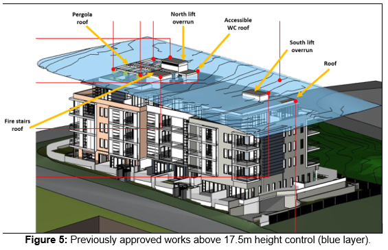
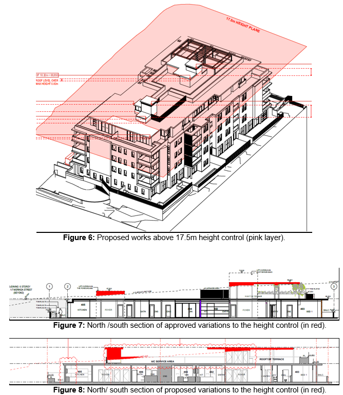
Comprehensive DCP Section 4.55 assessment
|
Control C.3 Residential Flat Buildings
|
Proposed
|
Complies
|
|
3.9 Design of Roof Top Areas
(a)
Roof top areas including podium area are to be designed for use as recreation
facilities where practicable and should be of high standard of finish and design.
A detailed landscape design and plan of roof top design is to be submitted
with the DA.
-
|
Roof top area includes recreational
facilities including:
· BBQ area
· Accessible toilet
· Seating area
· Landscaped planter box around the perimetre minimum of 1.8m in
depth and 1.1m in height
The s4.55 included amended landscaping
plans with full species listing for the planters
including banksias, frangipanis which have mature heights up to 5m to add
vegetation screening.
|
YES
|
|
3.9 Design of Roof Top Areas
(b) the design of exterior private open
space such as roof top gardens is to address visual and acoustic privacy,
safety, security and wind effects
|
The original DA approval included a roof
top area of approximately 170.59sqm which was only accessible from the
northern lift core. A condition in the DA consent included: The proposed roof top communal open space is to be increased in
area by approximately 70% of its current size.
The proposed s4.55 includes an extended
roof top communal open space area of approximately 125.37sqm. The extended
communal area is generally contained in the central portion of the building
and away from the single dwelling houses on adjacent sites to the south and
south-east.
The southern lift overrun and 1.6m wide
passage to the main communal area are located at least 18m to the south and
south east boundaries. This element is considered to be a transitionary area
where persons are not anticipated to occupy for extended periods.
The main trafficable area would be:
· Approx. 31m from the southern boundary and approx. 33.5m from the
building at 6 Merinda Street;
· Approx. 22m from the closest property boundary and approx. 30m
from the dwelling house at 28 Pinaroo Place.
(Refer to Figure 7 in this report).
The perimetre of the main communal area
also includes 1.8m deep and 1.1m high planter boxes.
Beyond the planters and vegetation, the
trafficable areas are a minimum 4m from the building edge which will reduce
sightlines to downward to the nearest neighbouring dwelling houses. Views
will largely be over the roofs of these dwellings.
The large separation of the extended roof
top communal area is not considered to result in unreasonable acoustics or
visual privacy impacts.
|
YES
|
|
3.14 Solar Access
(c) Where
adjacent dwellings and their open space already receive less than the
standard hours of sun, new development should seek to maintain this solar
access where practicable.
(d)
Council may accept a reduction in solar access for the subject site and
adjacent development if the topography and lot orientation (as distinct from
a preferred design) are such that the standard is considered unreasonable.
|
The approved
development included compliant building separation, and further separation at
the upper-storey to reduce total shadows. The setbacks were increased by an
additional 3m to accommodate the zone transitions
The s4.55
modification includes some additional roof top elements which exceed the
17.5m height control.
The applicant
has provided updated shadow diagrams from 9.00am through to 3.00pm in
midwinter.
The diagrams
confirm:
9.00am: Additional shadows on Merinda Street carriageway, the front
footpath, and setback of the (Hyecorp) residential flat building at 1 - 7
Merinda Street
10:00am: Additional shadows to front footpath/yard and roof of 10 Merinda
Street. (No impacts to open space or north facing windows)
11:00am: Additional area shadows fall on roof of 10 Merinda Street
(potentially additional shadows on northern elevation/windows)
12:00pm: Additional area shadows on side property boundary of 10 Merinda
Street and 8 Merinda Street (adjacent to pool patio) – majority of rear
yard receives full solar access. Small area of shadow on the roof of 28
Pinaroo Place.
1:00pm: Additional area of shadows on rear yard of 26 Pinaroo
Place. – However majority of rear yard receives solar access at 1.00pm.
2.00pm: Additional area of shadows on rear yard and roof of 26 Pinaroo
Place. Approx. 50% of rear yard still receives full sun.
3.00pm: Additional shadows on front yard of 24 Pinaroo Place, Council
footpath and street in front of 24 Pinaroo Place.
The LEP
controls permitted a 5-storey RFB to be approved on the site. The site
topography and orientation make maintaining the existing solar access for the
two southern adjoining properties unreasonable.
As a result of
the changes proposed in the s4.55 modification:
· No additional shadows fall on the sites that receive less than the standard hours of sun as a result of the
original approval.
· Sites that receive additional shadows as result of this s4.55
modification achieve a minimum 2 hours solar access and comply.
|
YES
|
|
3.17 Communal Open Space
a) A minimum of 25% of the site area is to be provided as
communal open space.
b) For mixed use sites, communal open space can be
provided on podiums and roof terraces subject to achieving privacy for
adjoining users.
|
The
application proposes to increase the roof top area by an additional 125.37sqm
(total – 295.96sqm) The proposal roof terrace achieves adequate privacy
for adjoining users.
Refer to DCP
section 3.9 which addresses privacy measures which have been incorporated
into the amended design.
|
YES
|
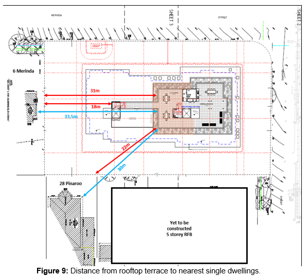
Lane
Cove LOCAL Environmental Plan 2009 (Section 79c(1)(a))
The proposal is
permissible, complies with the development standards for Floor Space
Ratio. The proposal would result in a variation to the Height controls as
required in the Lane Cove Local Environmental Plan 2009.
A clause 4.6
variation statement is not relevant in this instance, however the applicant has
submitted a clause 4.6 statement which is considered well founded and justifies
the variations of the height controls against the standards of the control,
objectives of the R4 zone and height do not raise any issues in regard to the
Lane Cove Local Environmental Plan 2009.
Other Planning Instruments
SEPP 55
Remediation of Land
The subject site
and adjoining sites are zoned for residential purposes. Given the types of uses
permissible within the residential zones, it is unlikely that the site would be
contaminated.
APPLICABLE REGULATIONS
The
Environmental Planning and Assessment Regulation 2000 indicates that the
standards for demolition and removal of materials should meet with AS 2601-2001
and therefore any consent will require the application of a relevant condition
seeking compliance with the Standard.
RESPONSE
TO NOTIFICATION (Section 79C(1)(d))
As a result of the notification period there were
10 submissions. Concerns raised in the submission are summarised below:
|
Concern
|
Comment
|
|
Concerns raised with additional visual
and acoustic privacy impacts due to the expansion of rooftop terrace.
|
The proposed
expansion of the roof top terrace is not anticipated to result in unreasonable amenity impacts. The main
trafficable areas with seating facilities/BBQ/ toilet are located at the
north and central sections of the building. They are approximately 30m from
the boundary closest neighbouring single dwellings to the south and south
east 6 Merinda Street and 28 Pinaroo Place) . The expanded roof terrace
includes a 1.1m high and 1.8m wide planter box. The revised landscaping plans
include a full species listing for the planters including banksias,
frangipanis which have mature heights up to 5m to add vegetation screening.
The southern lift core and connecting 1.6m wide passage would be a
transitionary area which persons are not anticipated to occupy for extended
periods.
|
|
Concerns with non-compliance with LEP
17.5m height control.
|
Although not
required under legislation, the applicant included a 4.6 variation statement which
is considered well founded.
The proposed variation to the height control is confined
to lift overruns, rooftop terrace pergola and a minor portion of the south
west corner of the building. The breaching elements do not give rise to any
significant amenity impacts with regard to privacy, view loss or
overshadowing as compared to a compliant building. The breaching elements are
located in the centre of the building which would not be readily visible from
either of the street frontages. In that regard, the non-compliant elements do
not contribute to any perceived unreasonable bulk and scale or visual impact
concerns.
|
|
Concerns that the proposal is out of
character with the area.
|
The site is
zoned R4 High density. The building is generally similar in scale to other
residential flat building (RFB) in the area.
· Directly west of the site is a RFB at 1- 7 Merinda Street which
included a 19.9m height of lift overrun or 13.7% variation to the height
control.
· North west of the site is an approval for a RFB at 28 – 34
Mindarie Street which included a lift overrun up to 22.2m in height or 26.86%
variation.
|
|
Concerns with additional shadows and
solar access
|
The LEP
controls permitted a 5-storey RFB to be approved on the site. The site
topography and orientation make maintaining the existing solar access for the
two southern adjoining properties unreasonable.
As a result of
the changes proposed in the s4.55 modification:
· No additional shadows fall on the sites that receive less than the standard hours of sun as a result of the
original approval.
· Sites that receive additional shadows as result of this s4.55
modification achieve a minimum 2 hours solar access and comply.
|
|
Concerns on shadows on solar panels of 26
Pinaroo.
|
The solar
access controls in the DCP relate to windows of habitable rooms and private
open space. The solar access controls do not prohibit shadows on solar panels
which can be erected as exempt development. Some additional shadow would fall
on the solar panels at 2.00pm as a result of the s4.55 modifications. Refer
to Figure 10.
Regardless of
the controls, the solar panels would achieve 4 hours solar access as no
additional shadows would fall on the solar panels of 26 Pinaroo Place between
9.00am at 1.00pm at mid-winter as a result of the s4.55 modifications. The
proposal is considered acceptable.
|
|
Concerns with privacy impacts from the
approved windows and balconies on the south and east elevations.
|
As per the
original DA condition (1A) the balconies balustrades of units 108, 208 and
308 on the southeast corner of the approved building have been modified to be
constructed with opaque glazing rather than clear glazing. The adjoining
living rooms of units have blank walls facing south-east. The above design
measures would help restrict overlooking to the nearest rear yards of the
dwelling houses of 6 Merinda and 28 and 26 Pinaroo Place. The east-facing
balconies of units 107, 207 and 307 have full height screens on the southern
perimetre to prevent views to 26 Pinaroo Place. These design options were
considered acceptable as part of the original approval.
To further
address the concerns of neighbours, the applicant has agreed to a condition
to delete the south facing kitchen widows to units 108, 208 and 308. Refer to
figure 13. These windows have would be located closest to the south-east
corner. The kitchens have secondary light sources from the glass
balcony doors. Deleting the windows would not prevent the kitchens from
comply with the BCA, but would prevent any southward
overlooking from the kitchens to rear yards of 6, 8 and 10 Merinda Street, and
28, 26 Pinaroo Place
It is
considered onerous to require other windows of bedrooms on the southern and
eastern facades to require high sill windows as the south-facing rooms
require adequate light and ventilation.
The other
properties mentioned in the submission are significantly further away from
the subject site:
· 8 Merinda approx. 17m further distance from the boundary of the
site.
· 10 Merinda approx. 34m further distance from boundary of the site
· 12 Merinda approx. 48m further distance from the boundary of the
site.
· 14 Merinda approx. 63m further distance from the boundary of site
· 16 Merinda approx. 77m further distance from the boundary of the
site.
·
|
|
Concerns with additional windows and
changes to windows. Concerns raised to privacy impacts on 6 Merinda Street.
|
No additional
windows are proposed on the south elevation towards 6 Merinda Street.
The original
DA had no windows to bedrooms of units 102, 202 and 302 which are required
under the BCA for light and ventilation. A condition was imposed in the
original DA approval requiring these bedrooms to include windows. The
proposed windows would face the east elevation toward the approved 5-storey
RFB at 20 and 22 Mindarie Street and 30 Pinaroo Place. Thee windows would not
overlook 28 Pinaroo Place or 6 Mindarie Street.
As stated
above, the applicant has agreed to a condition requiring 3 kitchen windows on
the southern elevation on levels 1, 2 and 3 to be deleted to increase privacy
measures and address the concerns of neighbours to the south. Refer to Figure
13 in this report.
|
|
Concerns that the proposal does not
reflect the transition between the R4 high density zone and the E4 low
density zone.
Request for a ‘graded building
stepping down with the southern end of the site.
|
The
original DA approval included design measures to accommodate the zone
transition between R4 and E4 zones.
The LCDCP
2010 requires development applications at the interface between the high and
low-density residential zones to demonstrate that the amenity of adjacent
houses has been a design consideration by stepping the building in at least
3m after the second level.
The site
adjoins E4 to the southern boundary and the southern section of the eastern
boundary. Under the Apartment Design Guide (ADG) the zone transition
habitable rooms at ground and 1st floor are permitted within 6m of
the boundary with lower density zones.
The
approved building (habitable rooms) are set back an additional 3m (total 9m)
from the southern and south eastern boundary from GF up to 4th level,
and setback 12m at 5th level.
The
setbacks comply. Therefore, the approved design would not only setback levels
1-4 but also has setback the ground floor an additional 3m from the boundary.
|
|
Concerns with impacts of common retaining
walls between the site and 28 Pinaroo Place.
|
An additional
draft condition is recommended requiring boundaries of adjoining properties 6
Merinda and 28 Pinaroo be secured by temporary fences throughout the
demolition and construction period.
|
|
Concerns with the 2m setback of the
driveway from the southern boundary with 6 Merinda Street. Including noise,
safety.
|
The setback
controls in the DCP relate to building setback (external walls) only. The
proposal building compiles with the DCP setbacks. There is no requirement for
the driveway to be setback a minimum 6m from the neighboring property as the
submission requests.
|
|
Recommendation that the carpark entrance
be relocated to Mindarie Street.
|
The s4.55
modification does not include changes to the approved vehicle access driveway
location on Merinda Street. Vehicle access is generally located at the lowest
location on site to minimise excavation.
|
|
Concerns with the landscaping between the
driveway and the southern boundary
|
The amended
landscape plans include a vegetation buffer in the 2m setback between the
driveway and the boundary of 6 Merinda Street including 3 Grey Myrtle trees
with a mature height of 4m - 6m and 9 Lilly Pilly shrubs with a mature height
up to 3m. The landscaping is considered acceptable. Refer to figure 11
below:
|
|
Concerns with the proposed location of
the substation/ fire hydrant booster
|
The substation
easement would be located approximately 11.8m from the southern boundary with
6 Merinda Street. A standard substation has specified height of approximately
1.8m. It is not anticipated to result in adverse amenity impacts.
|
|
Concerns with traffic/parking impacts of
the development.
|
No additional
units are proposed as part of this application.
The originally
approved apartment building is within the planned density for the site and is
a permissible use. The proposed car parking has been provided in accordance
with Council controls and was reviewed by Council’s traffic engineers
who determined the road network can accommodate the development of the site
for a residential flat building.
|
|
Concerns with approved colourbond fence
on southern boundary
|
Concerns raised that colorbond fence
would not provide adequate noise insulation from the driveway entrance. The
fence material is considered acceptable.
|
|
Concerns raised for alleged lack of
information for assessment.
|
A schedule of materials and finishes is
shown on the elevational plans.
The transition between the R4 and E4
zones and setbacks have been addressed in both the original and s4.55 report.
There is no requirement for a feasibility
study for population growth to be submitted with the DA. Increased population
growth was taken into consideration when the site and surrounding area were
rezoned to R4 High Density Residential under the provisions of Lane Cove LEP
2009, and the Mowbray Road Precinct Master Planning Study in 2011, following
requirements from the state government to increase residential populations in
the local government area.
|
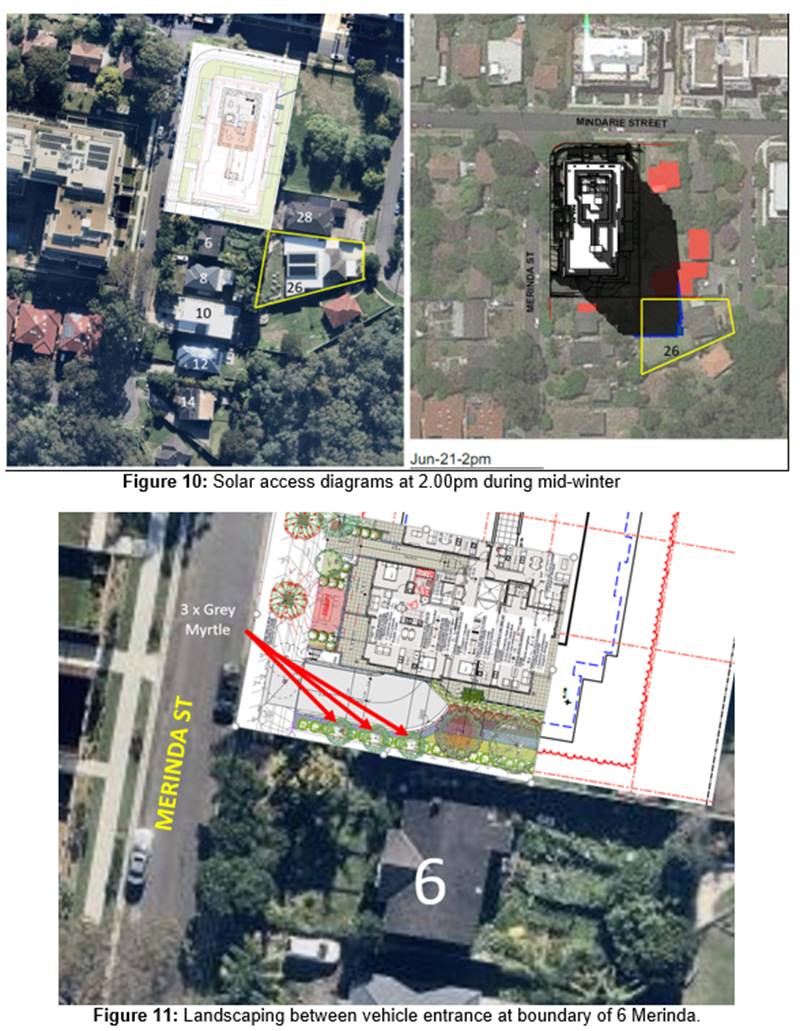
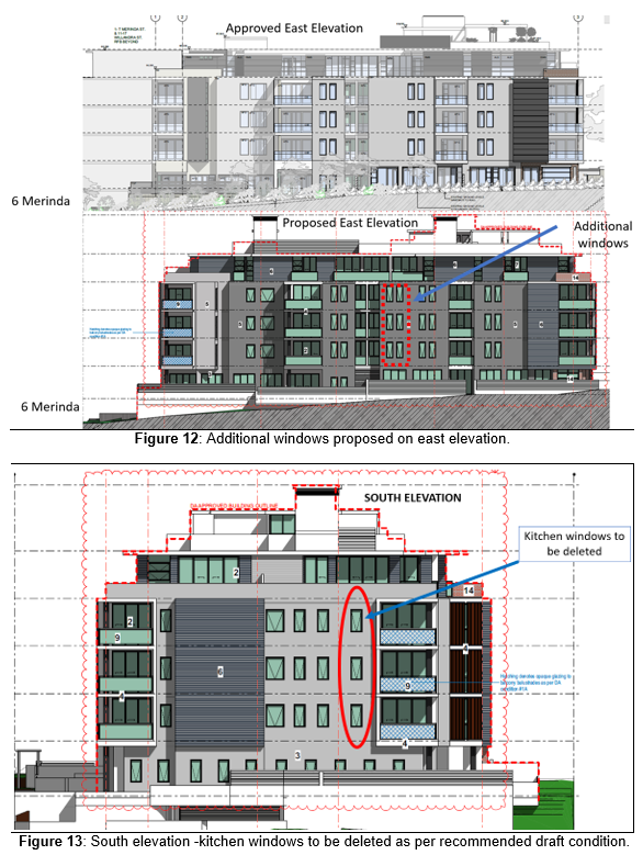
CONCLUSION
The matters for consideration
under section 4.15 of the Environmental Planning and Assessment Act 1979 have
been satisfied.
The application
complies with the Floor Space Ratio control which remains unchanged. The
proposal would result in a variation to the Height controls as required in the
Lane Cove Local Environmental Plan 2009.
A clause 4.6
variation statement is not strictly required in this instance, however the
applicant has submitted a clause 4.6 statement which is considered well founded
and justifies the variation of the height controls against the standards of the
control, and objectives of the R4 zone. The proposed
variations to the height control would be confined to lift overruns, rooftop
terrace pergola and a minor portion of the roof of the south west corner of the
building. The breaching elements do not give rise to any significant amenity
impacts with regard to privacy, view loss or overshadowing as compared to the
approved building. The breaching elements are predominantly located in the
centre of the building and would not be readily visible from either street
frontage. In that regard, the non-compliant elements do not contribute to any
perceived unreasonable bulk and scale or visual impact concerns.
The proposal
generally meets with the Part C Residential Development Objectives in the Lane
Cove Development Control Plan.
On balance the
proposed development as amended would be reasonable and therefore is
recommended for approval.
|
RECOMMENDATION
That pursuant to the provisions
of Section 4.55 of the Environmental Planning and Assessment Act, 1979 (as
amended), the Lane Cove Local Planning Panel at its meeting
of 15 June 2022, exercising the functions of Council as the consent
authority, grant consent to the Section 4.55 modification to Development Application
DA18/21 for the demolition of existing structures and construction of a
residential flat building on Lots 67, 68, 69 and 70
in DP 35865, known as 2–4 Merinda Street and 24–26 Mindarie
Street, Lane Cove North, subject to attached updated
draft conditions below:
A: Amend Condition (1) conditions of consent to
modify approved plans:
Approved Plans
and Documents
That the
development be in accordance with the following approved plans and documents:
|
Drawing No :
|
Title
|
Rev:
|
Prepared by:
|
Dated:
|
|
DA01
|
Lower Basement
|
|
Wolski Coppin
Architecture
Project No: 21903
|
29/01/2021
|
|
DA02
|
Basement
|
|
Wolski Coppin
Architecture
Project No: 21903
|
29/01/2021
|
|
DA03
|
Ground Floor
|
|
Wolski Coppin
Architecture
Project No: 21903
|
29/01/2021
|
|
DA04
|
Level 2 Typical (L1 + 3 SIMILAR)
|
|
Wolski Coppin
Architecture
Project No: 21903
|
29/01/2021
|
|
DA05
|
Level 4
|
|
Wolski Coppin
Architecture
Project No: 21903
|
29/01/2021
|
|
DA06
|
Roof Plan + site plan
|
A
|
Wolski Coppin
Architecture
Project No: 21903
|
11/02/2021
|
|
DA07
|
Cross + Long Section
|
|
Wolski Coppin
Architecture
Project No: 21903
|
29/01/2021
|
|
DA08
|
Driveway & Ramp Section
|
|
Wolski Coppin
Architecture
Project No: 21903
|
29/01/2021
|
|
DA09
|
Mindarie & Merinda Street Elevation
|
A
|
Wolski Coppin
Architecture
Project No: 21903
|
10/02/2021
|
|
DA10
|
South and East Elevation
|
|
Wolski Coppin
Architecture
Project No: 21903
|
29/01/2021
|
|
SA01
|
Site Analysis
|
|
Wolski Coppin
Architecture
Project No: 21903
|
29/01/2021
|
|
SA02
|
Site Context
Analysis
|
|
Wolski Coppin
Architecture
Project No: 21903
|
29/01/2021
|
|
CA01
|
Landscape Area Calculations
|
|
Wolski Coppin
Architecture
Project No: 21903
|
29/01/2021
|
|
FH01
|
Finishes 01
|
|
Wolski Coppin
Architecture
Project No: 21903
|
29/01/2021
|
|
FH02
|
Finishes 02
|
|
Wolski Coppin
Architecture
Project No: 21903
|
29/01/2021
|
|
PH01
|
Adaptable 01
|
|
Wolski Coppin
Architecture
Project No: 21903
|
29/01/2021
|
|
PH02
|
Adaptable 02
|
|
Wolski Coppin
Architecture
Project No: 21903
|
29/01/2021
|
|
PH03
|
Adaptable 03
|
|
Wolski Coppin
Architecture
Project No: 21903
|
29/01/2021
|
|
CC200370
E1
|
Cover
Sheet & Notes
|
A
|
ACOR
Consultants (CC) Pty Ltd
|
05/01/2021
|
|
CC200370
E2
|
Erosion
& Sediment Control Plan
|
A
|
ACOR
Consultants (CC) Pty Ltd
|
05/01/2021
|
|
CC200370
E3
|
Erosion
& Sediment Control Detail Sheet
|
A
|
ACOR
Consultants (CC) Pty Ltd
|
05/01/2021
|
|
CC200370
C1
|
Cover
Sheet & Notes
|
C
|
ACOR
Consultants (CC) Pty Ltd
|
12/01/2021
|
|
CC200370
C2
|
Stormwater
Management Plan – Ground (Part 1)
|
C
|
ACOR
Consultants (CC) Pty Ltd
|
12/01/2021
|
|
CC200370
C3
|
Stormwater
Management Plan – Ground (Part 2)
|
C
|
ACOR
Consultants (CC) Pty Ltd
|
12/01/2021
|
|
CC200370
C4
|
Stormwater
Management Plan – Basement
|
C
|
ACOR
Consultants (CC) Pty Ltd
|
12/01/2021
|
|
CC200370
C5
|
Stormwater
Management Plan -Lower Basement
|
C
|
ACOR
Consultants (CC) Pty Ltd
|
12/01/2021
|
|
CC200370
C6
|
Stormwater
Management Details Sheet No. 1
|
C
|
ACOR
Consultants (CC) Pty Ltd
|
12/01/2021
|
|
CC200370
C7
|
Stormwater
Management Details Sheet No. 2
|
C
|
ACOR
Consultants (CC) Pty Ltd
|
12/01/2021
|
|
DOCUMENT
|
REV
|
AUTHOR
|
DATED
|
|
BASIX
Certificate No. 1165735M_03
1284587M
|
|
Senica Consultancy Group Pty Ltd
Green Star Energy Solutions
|
28 January 2021
17 March 2022
|
|
Site
Waste Minimistaion and Operational Waste Management Report
SW20/11212
|
C
|
Senica
Consultancy Group Pty Ltd
|
09/012/2020
|
As amended
by the following plans
|
Drawing No:
|
Title:
|
Rev:
|
Prepared by:
|
Dated:
|
|
DA01
|
Basement 2 Floor Plan
|
J
|
design corp
|
26/04/22
|
|
DA02
|
Basement 1 Floor Plan
|
J
|
design corp
|
26/04/22
|
|
DA03
|
Ground Floor Plan
|
H
|
design corp
|
17/03/22
|
|
DA04-A
|
Level 1 Floor Plan
|
H
|
design corp
|
17/03/22
|
|
DA04-B
|
Level 2 Floor Plan
|
H
|
design corp
|
17/03/22
|
|
DA04-C
|
Level 3 Floor Plan
|
H
|
design corp
|
17/03/22
|
|
DA05
|
Level 4 Floor Plan
|
H
|
design corp
|
17/03/22
|
|
DA06- A
|
Roof Plan
|
H
|
design corp
|
17/03/22
|
|
DA06- B
|
Upper Roof Plan
|
H
|
design corp
|
17/03/22
|
|
DA07-A
|
Section 1
|
H
|
design corp
|
17/03/22
|
|
DA07-B
|
Section 2
|
H
|
design corp
|
17/03/22
|
|
DA08
|
Section 3
|
H
|
design corp
|
17/03/22
|
|
DA09
|
Elevations
|
H
|
design corp
|
17/03/22
|
|
DA10
|
Elevations 2
|
H
|
design corp
|
17/03/22
|
|
DA11
|
Elevations 3
|
G
|
design corp
|
17/03/22
|
|
LPCC 22 – 289
Page 1
|
Hardscape / Site Plan
|
C
|
Conzept
|
21/03/22
|
|
LPCC 22 – 289
Page 1
|
Landscape Plan Ground Floor
|
C
|
Conzept
|
21/03/22
|
|
LPCC 22 – 289
Page 1
|
Landscape Plan Level 4 & Roof Top
|
C
|
Conzept
|
21/03/22
|
|
LPCC 22 – 289
Page 4
|
Irrigation Plan
|
C
|
Conzept
|
21/03/22
|
|
LPCC 22 – 289
Page 5
|
Sections
|
C
|
Conzept
|
21/03/22
|
|
LPCC 22 – 289
Page 6
|
Specifications and Details
|
C
|
Conzept
|
21/03/22
|
|
LPCC 22 – 289
Page 7
|
Details
|
C
|
Conzept
|
21/03/22
|
(Condition amended June 2022)
B: Delete Conditions (1A), (2), (3) and (4)
1A. Balustrades
- The balustrades on the eastern perimeters of the balconies of units
108, 208 and 308 are to be constructed with either opaque glass or solid
upstand structures to prevent views to 28 Pinaroo Place.
Details
are to be provided on amended plans to the PCA Principal Certifying Authority
(PCA) for approval PRIOR TO SUBMISSION OF A CONSTRUCTION CERTIFICATE.
Reason: To reduce privacy impacts to the
neighbour at 28 Pinaroo Place.
(Condition deleted June
2022)
2. ROOF TOP
COMMUNAL OPEN SPACE
3.
(a) The
proposed roof top communal open space is to be increased in area by
approximately 70% of its current size. The increased size shall
not create any impacts on privacy of adjoining properties.
4.
(b) The
amended communal area is to include a planter box around the perimeter. The
adjacent rooftop service area will be required to be rearranged to
suit. The amended area must not include any feature which exceeds
the 17.5m height limit and must not involve movement or alteration of
the existing features of the rooftop communal area that are the subject of
the cl4.6 request, namely the pergola, lift overrun 1, accessible WC roof,
fire stairs roof and lift overrun 2.
5.
The landscape drawings
must be amended and submitted to Council’s Landscape Principal
Certifying Authority (PCA) for approval prior to issue of Construction
Certificate.
Article I.
Reason:
Communal amenity.
(Condition deleted June 2022)
3. WINDOWS
The plans and elevations are to be amended to ensure
bedroom 2 of Units 102, 202 and 302 have a window.
Details are to be provided to the PCA
Principal Certifying Authority (PCA) for approval prior to submission of a
Construction Certificate.
Reason: Light and ventilation.
(Condition deleted June 2022)
4. GROUND
FLOOR COURTYARD
The private courtyard on the eastern side of the
ground floor is to be amended so that it cannot be accessed by both Unit G02
and Unit G03.
The adjacent private courtyard on the eastern side
of the ground floor is to be amended so that it cannot be accessed by both
Unit G07 and Unit G11.
The plans are to be amended and fences or
walls at a height of 1.8m are to be erected within these courtyards to
fully separate the outdoor space of each unit. Details are to be
provided to the Principal Certifying Authority (PCA) for approval prior to
submission of a Construction Certificate.
Reason: Privacy and amenity.
(Condition deleted June
2022)
C: Add Conditions (4A) and (4B) to delete
kitchen windows and erect temporary fences to
property
boundaries.
Condition
(4A) South facing kitchen windows to units 108, 208 and 308 are required to
be deleted.
Details to submitted on plans to the Principal Certifying Authority (PCA)
prior the
issue of a
Construction Certificate.
(Condition
added: June 2022)
Reason:
Improve privacy and amenity.
Condition
(4B) A temporary fence is erected between the
boundaries of the subject site
and the neighbouring properties (in particular 28 Pinaroo Place and 6
Merinda)
throughout the demolition and construction periods.
(Condition added: June 2022)
Reason:
Security, safety and amenity.
D: Amend Condition (107) to included
updated Landscaping plans
107. Landscaping works are to be carried out in accordance with:
· Landscape plans 193.20/448A, 449A, 450A
(dated 10.02.21 and 451- 454; prepared by Iscape Landscape Architecture and
dated January 2021;
Landscape Specification prepared by Iscape landscape
Architecture dated December 2020.
|
LPCC 22 – 289
Page 1
|
Hardscape / Site Plan
|
C
|
Conzept
|
21/03/22
|
|
LPCC 22 – 289
Page 1
|
Landscape Plan Ground Floor
|
C
|
Conzept
|
21/03/22
|
|
LPCC 22 – 289
Page 1
|
Landscape Plan Level 4 & Roof Top
|
C
|
Conzept
|
21/03/22
|
|
LPCC 22 – 289
Page 4
|
Irrigation Plan
|
C
|
Conzept
|
21/03/22
|
|
LPCC 22 – 289
Page 5
|
Sections
|
C
|
Conzept
|
21/03/22
|
|
LPCC 22 – 289
Page 6
|
Specifications and Details
|
C
|
Conzept
|
21/03/22
|
|
LPCC 22 – 289
Page 7
|
Details
|
C
|
Conzept
|
21/03/22
|
·
The landscape
works shall be completed PRIOR TO ISSUE OF THE
OCCUPATION CERTIFICATE.
(Condition
amended June 2022)
Reason: Landscaping requirement
E: Retain all remaining conditions being (5) –
(106) and (108) - (115)
|
ATTACHMENTS:
There are no supporting documents for this report.


