Lane Cove Local Planning Panel Meeting 30
November 2022
s4.55 - 266 Longueville
Road, Lane Cove
Subject: s4.55
- 266 Longueville Road, Lane Cove
Record No: DA17/117-01 - 66518/22
Division: Environmental
Services Division
Author(s): Robert
Montgomery - Independent Assessor
|
Property:
|
Lot 1 in DP 321353, Lot 1 in DP 1227921
and Lot 2 in DP 1227921
|
|
DA No:
|
DA117/2017
|
|
Date Lodged:
|
18/11/2022
|
|
Cost of Work:
|
$81,345,000.00
(unchanged)
|
|
Owner:
|
Lane Cove Council
|
|
Applicant:
|
Longueville The Village Pty Ltd
|
|
Description of the proposal to appear on
determination
|
Modification
pursuant to s4.55(1A) of Development Consent
DA117/2017 by changing the wording of conditions 2.1, 2.2, 4, 5. 6 and 9 to
enable multiple construction certificates and occupation certificates to be
issued for various components of the development.
|
|
Zone
|
R2 Low Density Residential
|
|
Is the proposal permissible within the
zone
|
Yes
|
|
Is the property a heritage item
|
No
|
|
Is the property within a conservation
area
|
No
|
|
Is the property adjacent to bushland
|
Yes
|
|
BCA Classification
|
Class 9c
|
|
Stop the Clock used
|
No
|
|
Notification
|
Not Required
|
REASON FOR REFERRAL
The modification application is referred to the Lane
Cove Local Planning Panel as Lane Cove Council is the owner of the land.
EXECUTIVE SUMMARY
This assessment report is prepared by Robert
Montgomery, an independent town planner engaged by the Council to assess the
application.
The Section 4.55(1A) application seeks to modify
Development Consent DA117/2017 by changing the wording of certain conditions to
enable multiple construction certificates to be issued for various components
of the development. The modification is administrative in nature and no
physical changes to the approved development are proposed.
Approved by the
Sydney North Planning Panel on 6 September 2021, the development is described
as:
“Construction of a seniors
housing development comprising 70 bed residential aged care facility, 82
independent living units/self-contained dwellings, with basement car parking
for 122 vehicles, new public park and facilities and landscaped through-site
link.”
The Sydney North Planning Panel recently delegated all
functions relating to determination of applications to modify consent to
Council’s General Manager. However, as the Council is the owner of
the land, the application is referred to the Lane Cove Local Planning Panel for
determination.
In accordance with the Lane
Cove Community Participation Plan, the application was not notified due to the
minor nature of the proposed modifications.
The modification application has been assessed under
the provisions of Sections 4.15 and 4.55 of the Environmental Planning and
Assessment Act, 1979, and is recommended for approval.
SITE
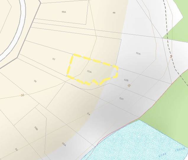
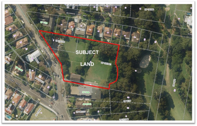
The site comprises three parcels of land described as
Lot 1 in DP 321353, Lot 1 in DP 1227921 and Lot 2 in DP 1227921, with a total
area of 9,204m2. The site is irregular in shape and has a northern
boundary of approximately 147m, an eastern frontage to Lane Cove Golf Course of
approximately 81m, a southern boundary of approximately 83m and a combined
western frontage to Longueville Road of approximately 103m.
The site has a fall from north to south of 0.85m along
Longueville Road, and a fall from west to east of approximately 18m, from 57.83
AHD near the north-western end of the street frontage to 40.00 AHD near the
eastern most edge of the development area. Beyond the eastern edge of the
development site, there is a further fall to the east of approximately 10-11m
to the Lane Cove golf course.
The
land is occupied by two disused bowling greens, a paved car parking area in the
north-western corner of the site and a brick and weatherboard building near the
south western corner of the site.
Vegetation on the site comprises a mix of
lawn areas and dense scrub around the bowling greens and a grove of trees
located to the north of the lower bowling green. Dense bushland occupies
the area to the east of the development site, towards the golf course.
Development in the surrounding area comprises
a mix of single and two storey free standing dwelling houses, multi storey
residential flat buildings and recreational facilities.
To the north is a residential flat building
at Nos. 250-252 Longueville Road and detached dwelling houses at Nos. 42-58
Richardson Street. To the east is dense bushland on steep topography that
leads down towards the Lane Cove Golf Course.
To the south is, a part three and part four
storey residential flat building known as ‘Timbertops’. Development on the western side of Longueville Road
comprises the former Masonic Lodge and detached dwellings.
Figure 1: Satellite Image. Source: NSW
LPI SIX Maps
PREVIOUS APPROVALS/HISTORY
The land is owned by Lane Cove Council, which proposes
to lease the land to the applicant for a period of 99 years.
The land was rezoned from public recreation to R4 High
Density Residential in recent years. The rezoning was initiated by the
Council, which had identified a need for high density accommodation for seniors
in this locality. The land was also reclassified to Operational Land
under the provisions of the Local Government Act 1993.
The development benefits from a Certificate of Site
Compatibility under Clause 25(4)(a) of State Environmental Planning Policy
(Housing for Seniors or People with a Disability) 2004. The effect of
this Certificate is to increase the maximum permissible floor space ratio from
1.1:1 to 1.6:1.
Approved by the Sydney North Planning
Panel on 6 September 2021, the development is described as:
“Construction of a seniors
housing development comprising 70 bed residential aged care facility, 82
independent living units/self-contained dwellings, with basement car parking
for 122 vehicles, new public park and facilities and landscaped through-site
link.”
Since development consent was issued, the site has
been secured by construction fencing and site preparation works have commenced.
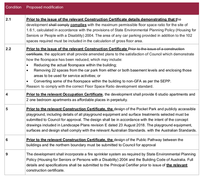
PROPOSED MODIFICATION
The application proposes to
modify the wording of conditions as follows:
· Amend the wording of condition 4 to allow
for satisfaction of the condition prior to the relevant occupation certificate.
· Amend the wording of conditions 2.1, 2.2, 5. 6, and 9 to allow for
satisfaction of the conditions prior to the relevant construction certificate.
The proposed amendments are shown in bold
and underlined as detailed in the table below:
SECTION
4.55 ASSESSMENT
The application is made under section 4.55(1A) of the Environmental
Planning and Assessment Act, 1979. This section relates to
“modifications involving minimal environmental impact” and provides
that the consent authority may modify the consent if:
(a) it is satisfied that the
proposed modification is of minimal environmental impact, and
(b) it is satisfied that the
development to which the consent as modified relates is substantially the same
development as the development for which the consent was originally granted and
before that consent as originally granted was modified (if at all), and
(c) it has notified the
application in accordance with—
(i) the regulations, if the
regulations so require, or
(ii) a development control plan, if the
consent authority is a council that has made a development control plan that
requires the notification or advertising of applications for modification of a
development consent, and
(d) it has considered any
submissions made concerning the proposed modification within any period
prescribed by the regulations or provided by the development control plan, as
the case may be.
In relation to section 4.55(1A) (a) and (b), the Panel
is advised that the proposed modification is administrative in nature only and
does not involve any physical changes to the development. Accordingly,
the Panel can be satisfied that the proposed modification is of minimal
environmental impact and is substantially the same development as the
development for which the consent was originally granted.
In relation to section 4.55(1A)(c), there is no
specific requirement under the Environmental Planning and Assessment
Regulation, 2021 or under the Lane Cove Development Control Plan which
requires this application to be notified. Council’s Community Participation Plan 2019
provides exemptions in certain circumstances, including:
“Notification may be dispensed
with, except in relation to heritage items or heritage conservation areas,
when:
1. Council
is of the opinion an amended or substituted application (including applications
under s4.55 or s8.2 of the) varies in a minor respect from the original
application that was previously notified.”
It is considered that notification is not required as
the application clearly satisfies the criteria for exemption within the
Community Participation Plan. It is also relevant to note that there will
be no different environmental impacts compared to the development as originally
approved, and no physical changes. In the circumstances, it is considered
that there would be no utility in notifying the development.
Pursuant to Section 4.55(3) of the Act, the consent authority must also take into
consideration the reasons given by the consent authority for the grant of the
consent that is sought to be modified. The reasons for the decision are
contained within the:
· Sydney North Planning Panel Determination and
Statement of Reasons dated 6 September 2021;
· Assessment Report to SNPP dated 11 July
2018; and
· Supplementary Assessment Report to SNPP dated
4 August 2021.
Copies of these documents are attached.
Having reviewed and considered the reasons
for determination, it is concluded that the proposed modification is not in
conflict with any of those reasons.
SECTION 4.15(1) MATTERS FOR CONSIDERATION
In determining an application for
modification of a consent under this section 4.55, the consent authority must
take into consideration such of the matters referred to in section 4.15(1) as
are of relevance to the development the subject of the application.
Notwithstanding that the modification is
administrative in nature only, the following section 4.15(1) matters have been
considered.
Environmental
Planning Instruments
The following Environmental
Planning Instruments apply to the land:
· State Environmental Planning Policy
(Resilience and Hazards) 2021;
· State Environmental Planning Policy
(Biodiversity and Conservation) 2021;
· State Environmental Planning Policy
(Transport and Infrastructure) 2021;
· State Environmental Planning Policy (SEPP) No. 65
Design Quality of Residential Flat Development;
· State Environmental Planning Policy
(Housing for Seniors or People with a Disability) 2004;
· State Environmental Planning Policy
(Building Sustainability Index: BASIX) 2004;
· Lane Cove Local Environmental Plan 2009.
Note: State Environmental
Planning Policy (Housing) 2021 is not applicable, due to the savings provision
found in schedule 7A (2)(d) of the Housing SEPP. Accordingly, State
Environmental Planning Policy (Housing for Seniors or People with a Disability)
2004 continues to apply to the development.
No amendments are proposed other than
procedural matters relating to construction certificates and occupation
certificates. The development therefore will remain identical to that
approved. Notwithstanding, consideration of the relevant provisions of
the above Environmental Planning Instruments confirms that the proposed
modification has no impacts.
Draft Environmental Planning
Instruments
There are no draft instruments.
Development
Control Plans
Lane Cove Development Control
Plan 2010 (LCDCP) applies to the site. The development application
was assessed against the provisions of the LCDCP in the assessment reports
dated 11 July 2018 and 4 August 2021.
As stated in this report, the application was not
notified (in accordance with the Lane Cove Community Participation Plan) due to
the minor nature of the proposed modifications.
Regulations
The Environmental Planning and Assessment
Regulation, 2021 (EP&A Reg) contains provisions relating to
modification applications. The following clauses apply:
Table 1: Summary of Relevant Clauses in the EP& A Reg,
2021
|
Clause
|
Summary
|
Comment
|
|
98
|
Sets out who can make an application
|
Complies
|
|
99
|
Form, particulars and lodgement
|
Complies
|
|
100
|
Content required
|
Complies
|
|
104
|
Consent authority may ask for
additional information
|
Not required
|
|
105
|
Requires notification of 4.55(1A) if
required by local community participation plan
|
Lane Cove community participation
plan does not require notification
|
|
109
|
Relevant concurrence and approval
bodies to be notified
|
The original DA was referred to NSW
RFS and RMS for comment only. There was no concurrence or approval
role. Therefore, notification is not required.
|
Likely
Impacts of the Development
The development consent conditions assume that one
construction certificate would be issued for the entire site. However,
this is a large development with many distinct components, including
demolition, geotechnical work, building components, construction of a public
park and public walkway.
The proposed amendments to conditions 2.1, 2.2, 5, 6
and 9 are intended to facilitate the issue of separate construction
certificates for the various components. This would be expected in a
project of this size. The way in which these conditions are currently
structured would prevent a logical approach to the project unless various
matters which may not relate to the actual work were satisfied.
The proposed amendment to condition 4 is intended to
facilitate the issue of separate occupation certificates. Under the
current condition structure, no occupation certificate could be issued until
the affordable units were physically provided. The current condition would
prevent the issue of multiple occupation certificates to certify that various
components of the project have been satisfied and is likely to hinder the
logical progression of the development. Amending condition 4 as proposed
does not alter the applicant’s obligation to provide affordable units
within the development.
In assessing the modification, it became apparent that
condition 4 of the consent is located under the heading “prior to issue
of a construction certificate”. Clearly this is incorrect. It
is also noted that condition 154 (under the heading “prior to issue of an
occupation certificate”) requires that a restrictive or positive covenant
be registered for the continued provision of affordable places prior to the
issue of an occupation certificate. Although not raised by the applicant,
it is considered that this condition should also be modified to refer to
“the relevant occupation certificate”. It is proposed to
incorporate amended condition 4 into this condition as shown in the
recommendation.
The Environmental Planning
and Assessment Act,1979 and the Environmental Planning and Assessment (Development
Certification and Fire Safety) Regulation, 2021 recognises that multiple
construction certificates can be issued in respect of one project.
It is agreed that the proposed modification is a
logical approach to this major development. The modified conditions will
facilitate a clearer approach and prevent unnecessary time, costs and
uncertainty for the certification process.
It is considered that no impacts arise as a
consequence of the modification.
Suitability of the Site
The site was considered
suitable for the development when the development application was assessed and
approved.
Any
Submissions Made
The application was not notified and therefore no
submissions were received.
The Public Interest
It is considered that the proposed modification
will facilitate the Objects of the Environmental Planning and Assessment Act,
1979. In particular the following Objects are relevant:
(c) to promote the orderly and economic use
and development of land,
(d) to promote the delivery and maintenance
of affordable housing,
(h) to promote the proper construction and
maintenance of buildings, including the protection of the health and safety of
their occupants,
Accordingly, it is considered that the approval of the
modification serves the public interest.
REFERRALS
No internal or external referrals are
required.
CONCLUSION
The
modifications proposed are minor and administrative in nature. There will
be no additional or different impacts as a consequence of the modifications.
The
application satisfies the requirements of Section 4.55(1A) of the Environmental
Planning and Assessment Act, 1979 and the relevant Regulations.
Accordingly, the application is recommended for approval.
|
RECOMMENDATION
That:-
A. The Panel is satisfied that the proposed
modification:
· is of minimal environmental impact;
· is substantially the same development as the
development for which consent was originally granted and before that consent
was modified;
· has been notified (or not notified because not
required); and
· has been assessed having regard to the relevant
matters in s4.15(1) EP&A Act.
The Panel has taken into account the reasons of the
consent authority that granted the consent that is sought to be modified.
B. Pursuant to the provisions of Section 4.55 of the Environmental
Planning and Assessment Act, 1979, the Lane Cove Local Planning Panel at its
meeting of 30 November 2022, exercising the functions of Council as the
consent authority, approve the modification to Development Consent DA117/2017
for a seniors living development at 266 Longueville Road Lane Cove, subject
to the following updated conditions (changes are bolded):
Condition 2.1 is amended to read:
Prior to
the issue of the relevant Construction Certificate, details demonstrating that the development complies
with the maximum permissible floor space ratio for the site of 1.6:1,
calculated in accordance with the provisions of State Environmental Planning
Policy (Housing for Seniors or People with a Disability) 2004. The area
of any car parking provided in addition to the 102 spaces required must be
included in the calculation of gross floor area.
Condition 2.2 is amended to read:
Prior to
the issue of the relevant Construction Certificate, the applicant shall provide amended plans to the
satisfaction of Council which demonstrate how the floorspace has been
reduced, which may include:
• Reducing the actual
floorspace within the building;
• Removing 22 spaces
from the car park from either or both basement levels and enclosing those
areas to be used for service activities; or
• Converting some of
the floorspace within the building to non-GFA as per the SEPP.
Condition 4 is deleted.
Condition
5 is amended to read:
Prior to
the issue of the relevant Construction Certificate, the design of the Pocket Park and
publicly accessible playground, including details of all playground equipment
and surface treatments selected must be submitted to Council for
approval. The playground shall be designed in accordance with the
intent of the concept drawings included in Landscape Plans revision E dated
23 August 2018. The playground equipment, surfaces and design shall
comply with the relevant Australian Standards. with the Australian Standards.
Condition
6 is amended to read:
Prior to
the issue of the relevant Construction Certificate, the design of the Public Pathway
between the buildings and the northern boundary must be submitted to Council
for approval.
Condition 9 is amended to read:
The development shall incorporate a fire sprinkler system as
required by Sate Environmental Planning Policy (Housing for Seniors or
Persons Living with a Disability) 2004 and the Building Code of
Australia. Full details and specifications shall be submitted to the
Principal Certifier prior to issue of the relevant Construction
Certificate.
Condition 154 is amended to read:
The development shall provide 6 studio apartments and 2 one
bedroom apartments as affordable places in perpetuity. Prior to the
issue of the relevant Occupation Certificate, a restrictive or positive
covenant shall be registered on the land for the continued provision of
affordable places identified in this approval in perpetuity, prior to the
issue of an occupation certificate.
|
Mark Brisby
Executive Manager
Environmental Services Division
ATTACHMENTS:
|
AT‑1 View
|
Sydney North Planning Panel determination and Statement of
Reasons dated 6 September 2021
|
4 Pages
|
Available Electronically
|
|
AT‑2 View
|
Assessment Report to SNPP dated 11 July 2018
|
28 Pages
|
Available Electronically
|
|
AT‑3 View
|
Supplementary Assessment Report to SNPP dated 4 August
2021
|
13 Pages
|
Available Electronically
|
|
AT‑4 View
|
Development consent dated 6 September 2021
|
14 Pages
|
Available Electronically
|
Lane Cove Local Planning Panel Meeting 30
November 2022
Section 4.55: 31 Fox
Street, Lane Cove
Subject: Section
4.55: 31 Fox Street, Lane Cove
Record No: DA21/14-01 - 58477/22
Division: Environmental
Services Division
Author(s): Andrew
Thomas
|
Property:
|
31 Fox Street,
Lane Cove
|
|
DA No:
|
D14/21
|
|
Date Lodged:
|
26.7.22
|
|
Cost of Work:
|
N/a: Section
4.55 amendment
|
|
Owner:
|
Premier One
Estate Pty Ltd
|
|
Applicant:
|
George Tawaf
|
|
Description of the proposal to appear on determination
|
Section 4.55
modification of consent for amendment of DA14/21 for alterations and
additions to the existing dwelling house, subdivision and construction of a
new dwelling house and the amendment of condition 12.
|
|
Zone
|
R2 Low Density
Residential
|
|
Is the
proposal permissible within the zone
|
Yes
|
|
Is the
property a heritage item
|
No
|
|
Is the
property within a conservation area
|
No
|
|
Is the
property adjacent to bushland
|
Yes
|
|
BCA
Classification
|
Class 1a and
10b
|
|
Stop the Clock
used
|
No
|
|
Notification
|
Neighbours The
same properties as per the DA.
Ward Councillors Central
Progress
Association None
operates
Other
Lane Cove Bushland and
Conservation Society
|
REASON FOR
REFERRAL
The s.4.55
application is referred to the Lane Cove Local Planning Panel because the Panel
determined Development Application 14/21 in September 2021 following significant
concerns raised by adjoining residents.
EXECUTIVE
SUMMARY
· The site is known as 31 Fox Street, Lane Cove and has an area of
1,126m2.
· In summary, Development Application 14/21 (D14/21) proposed:
- the
subdivision of the site into two Torrens title lots;
- alterations
and additions to the existing dwelling house on the proposed front lot 1;
- a
two storey dwelling house on the proposed rear lot 2; and
- fences,
retaining walls and landscaping.
· The Panel approved D14/21 in September 2021 subject to a deferred
commencement consent.
· Council granted an operative consent in November 2021.
· Demolition-related works addressing the subdivision of the site have
commenced.
· The s. 4.55 application (the/this application) is for amendment of
the approved alterations and additions to the existing part single and part two
storey dwelling house on the approved front lot 1 (the/this front lot). This
lot has an approved area of almost 567m2 and a 15.24m wide
frontage to Fox Street. On the submitted plans it is shown as 31A Fox Street,
an indication of its possible future address. The amendments would:
- still result in a part
single and part two storey dwelling house;
- reposition the garage from
the rear of its approved lower/ground floor level additions to the front of
this level;
- provide direct access from
the habitable rooms at this same level to its rear yard;
- seek to address visual and
acoustic privacy-related matters for the residents of 29 Fox Street on the east
side of this front lot; however, overlooking of the dwelling house on the west
side of this same lot, at 33 Fox Street, would need to be addressed by the
treatment of a side window; and
- replace the existing and
approved hipped tiled roof with a sawtooth metal roof.
· No amendments are proposed to either the approved subdivision plan
or to the new dwelling house approved on the rear lot 2.
· A recent request has been added to the application seeking a
reduction in the diameter of a stormwater pipe in a subdivision-related
condition of the consent (condition 12).
· Four submissions have been received in response to Council’s
notification of the application. The concerns raised in the submissions, from
the owners of 29, 33 and 35 Fox Street and 80A River Road West, include:
- the proposal is not a s.
4.55 application and should be a new development application;
- the proposal’s design
changes and their impact on the streetscape and character of housing in the
local area;
- noise from the repositioned
garage and its impact on the residents of 29 Fox Street;
- the impact of ancillary
structures on the residents of 33 Fox Street; and
- the encroachment of a bay
window into the front setback area.
· Revised, additional and supplementary plans have been submitted
that, inter alia, have:
- reduced gross floor area to
ensure compliance with the floor space ratio standard of the Lane Cove Local
Environmental Plan 2009 (the LEP);
- reduced the depth of a rear
first floor level terrace to ensure compliance with the maximum permitted
under the Lane Cove Development Control Plan 2009 (the DCP);
- confirmed a privacy screen
along the eastern façade would be fixed;
- provided details of the
motor for a garage door and an acoustic wall;
- provided an elevation and
details of a front fence;
- confirmed the width of the
driveway crossing;
- addressed overall and wall
height calculations; and
- confirmed swept paths.
The revised, additional and supplementary plans were sent to all the
four neighbours’ who made a submission.
· The amendment of:
- the approved alterations
and additions to the existing dwelling house on the front lot are reasonable;
and
- the amendment of condition
12 is supported by Council.
· The application is recommended for approval subject to the following
draft changes to the consent:
- the amendment of conditions
1,12 and 56;
- the deletion of conditions
17 and 18;
- the inclusion of conditions
17a and 21a - 21d; and
- the retention of the other
existing conditions of the consent.
SITE
The site was
described in the original report. Whilst the locality circumstances have not
changed since that time, some demolition-related works relating to the
subdivision approved under D14/21 have commenced. These works include the
demolition of an attached garage and room above along the east side of the
existing dwelling house (to enable construction of a wider and longer driveway
that would provide access to both approved lots) and a swimming pool and the
removal of most of the site’s trees.
APPROVAL
The Lane Cove Local Planning Panel (the Panel)
At its meeting of 29 September 2021 the Panel
granted a deferred development consent to Development Application 14/21 for
the subdivision of the site into two Torrens title lots, alterations and
additions to the existing dwelling house, a proposed dwelling house, fences,
retaining walls and landscaping on existing Lot 22, DP 12009 and known as 31
Fox Street, Lane Cove.
Operative
consent
The applicant
addressed the deferred matters on revised plans. Council issued an operative
consent by letter dated 22 November 2021 subject to the conditions under Part B
of the Recommendation to this Division’s
report.
PROPOSAL
|
Section
4.55 application (the application)
The
application is for amendment of the alterations and additions to the existing
dwelling house on the front lot, some of its fences and retaining walls and
landscape-related matters.
The
description on the application states:
- Improved privacy
measures to mitigate overlooking towards 29 & 33 Fox Street.
- A masonry fence along
the portion of driveway adjacent (sic) the garage door to provide acoustic
separation to the neighbours at 29 Fox Street.
- A modified roofline to
reduce bulk, scale and overshadowing.
Amendments in
this application include:
· alterations and additions to both levels of the existing dwelling
house within the front lot and alterations to its roof and ancillary
structures;
· a fence along this same lot’s common eastern side boundary
to 29 Fox Street and an acoustic fence abutting this same boundary fence
facing the proposed garage;
· a revised front fence;
· revisions to retaining walls; and
· landscape-related matters.
In October
2022 a request to reduce the diameter of the stormwater pipe required in
condition 12 was added to the application.
Details of
these amendments are addressed under the sub-headings that follow.
Dwelling
house
(i) Ground floor level
· Would maintain its approved finished floor level (FFL) of 41.76
towards the front and lower it to Reduced Level (RL) 41.02 at the rear level
with the rear yard.
· Under this application no external door to the subfloor area at
the front southwest corner is proposed and its internal walls would be
bricked-in. Adjoining the subfloor area an approved bathroom and cellar are
both deleted, a laundry retained and a powder room proposed beneath the
approved internal stairs to the floor level above.
1)
· The approved attached double garage would be relocated from the
rear to its front southeast corner where it would replace an approved
bedroom; the garage door would have sliding battens. Adjoining the garage
would be a bedroom and ensuite which, under revised plans, has been set in
from the existing east wall of the dwelling house. It would replace a
slightly smaller approved bedroom that included a courtyard along its east
side.
A 1.8m high x 140mm thick acoustic block wall within the
front lot and facing the relocated garage is proposed abutting a proposed
fence on its eastern side boundary. Revised plans have increased the length
of this proposed wall from the width of the garage to about 8.1m
· The approved rear garage and adjoining terrace would be replaced
by an open plan rumpus room and kitchenette with direct access to the rear
yard. Revised plans have reduced the floor area of both these rooms by
setting them in 1.37m from the approved rear wall.
(ii) First
floor level
· Its front patio would be raised by 50mm.
2)
· Whilst an approved rear terrace would remain, its proposed depth
of 3.57m has been reduced to 3m on revised plans; this is consistent with a
requirement of the deferred commencement consent that required its depth to
be reduced to a maximum of 3m to comply with the DCP.
· The main amendments are:
-
a cantilevered bay window the width of the front bedroom, about 1.2m in depth
and the height of this level that would have a glass roof with a pitch of about
600;
-
translucent privacy glass is proposed on all
three of the windows on its west façade; the approved width of the
stair window would be unchanged and fixed but the window for each of the
other two rooms would be wider than approved and both would open sideways;
-
the four approved windows on its east façade would be replaced by
three wider windows and a 2.7m high x 200mm wide privacy screen with fixed
angled blades that would extend along its entire length, including its rear
terrace and the access stairs to its front patio.
(iii) Roof
· The existing terracotta tiled roof would be removed and it, and an
approved higher tiled roof over both the centre and the approved rear
extensions, would be replaced by a sawtooth metal roof over all the dwelling
house.
· The ridge height of the existing dwelling house varies between RL
48.57 and RL 49.69. Its approved ridge height of RL 50.50 would be lowered to
a maximum height of RL 49.14 and a minimum height of RL 47.74 for each
box gutter.
(iv)
Materials and construction
The approved
cement rendered and painted finish for the external walls of the existing
dwelling house and its rear additions would be amended to a rendered brick
finish with painted roof cladding.
(v)
Ancillary structures
The ancillary
structures proposed within the western side setback of the dwelling house on
the front lot are:
· 3 x 4,000 litre rainwater tanks, each 1.785m high x 2.9m long x
700mm wide; and
· 2 x air conditioning units.
Fences
(i) Front
The approved
1.2m high front fence would be replaced by a 900mm high steel framed fence
with angled palings matching those of the proposed privacy screen along the
east façade of the first floor level of the dwelling house.
The fence
would include an entry gate, next to which would be a rendered masonry wall
650mm wide, about 3m long and with a variable height of between 900mm and
1.5m that would include a planter and two mailboxes. This wall would be
located next to the western side of the driveway. On the other side of this
wall would be entry steps that would connect to proposed paving within the
front yard.
(ii)
Side
The existing
timber fence along the eastern side boundary of the front lot would be
replaced with a 1.8m high timber paling fence.
Retaining
walls
The two
approved retaining walls behind the front fence, and another at right angles
to it, would generally be unchanged under this application.
Landscaping
The landscape
plan submitted with the DA showed a proposed general level of RL 43.20 for
the front lot’s front yard and RL 40.68 for its rear yard.
The site plan
for this application shows the proposed general level of its front yard at RL
43.60 and the level of its rear yard as being variable. At RL 43.60, its
front yard would be similar to the average of its existing fall and that
shown on the DA. Abutting the dwelling house its rear yard would be similar
to the FFL of RL 41.02 for the proposed ground floor level and about 300mm
above both its existing general level and the level shown on the
DA.
As occurred
with the DA, a landscape plan has also been submitted with this application
even though a landscape plan was not approved or required. This plan states
that it addresses the planting required by landscape-related condition 83. As
this condition, and condition 102, address the planting required, including
replacement planting, this plan does not need to be assessed.
2.
Condition 12 amendment
Condition 12,
being one of the conditions relating to the approved subdivision of the site,
states:
(a)
(X4) Easement Requirements: The following additional easement is to be created prior
to the release of the Subdivision Certificate:
• a 1.8m wide drainage
easement through proposed Lot 2 in favour of proposed Lot 1 for the
proposed 225mm diameter pipe as per Section 12.1 of Part O Stormwater
Management of the Lane Cove DCP 2009
The creation of this easement is to satisfy
Section 12.3.1 under the DCP. Standard wordings are to be obtained from
Council.
Reason: To ensure stormwater infrastructure is in
accordance with Australian Standards and Council’s requirements.
A request has
been added to the application seeking to reduce the diameter of the required
stormwater pipe from 225mm to 150mm in this condition.
This request
is to avoid construction of an access pit 5m below ground within the
adjoining bushland reserve known as Tennyson Park located at the rear
of the site. A pipe with a smaller diameter of 150mm would be able to connect
into Council’s existing stormwater pipe.
|
PROPOSAL DATA/COMPLIANCE
The Lane Cove
Local Environmental Plan 2009
Zoning: R2
Low Density
Total site
area: 1,261m2.
The area of
the approved front Lot 1 is 566.9m2
and 455.3m2 excluding the right of
carriageway*.
The following
table addresses the two LEP standards relevant to the amendments under this s. 4.55 application for the dwelling house
on this front lot.
|
|
Approved
|
Proposed
|
Standard
|
Complies
|
|
Floor
space ratio
|
0.5:1
|
0.5:
1**
|
0.5:1*
(227.7m2)
|
DA
: Yes - compliance achieved by a gross floor space reduction of 1.5m2 and
the deletion of both a proposed access door to an existing subfloor area and
the air conditioning condenser to a proposed subfloor area under point 1 of a
deferred commencement consent.
S.
4.55: Yes - revised plans have ensured compliance by reducing gross floor
area by about 19.5m2.
|
|
Height
of buildings
|
8.74m
|
8.34m
|
9.5m
|
DA:
Yes
S.
4.55: Yes
|
* Clause 4.5
(6A) requires the area of an access handle to be excluded from site area in the
calculation of floor space ratio (FSR) under subclause (3). Therefore, the
proposed FSR is based on the area of this approved lot excluding the area of
the approved right-of-carriageway parallel to, and along, its eastern side
boundary that would also serve the approved rear lot.
** Revised floor
plans submitted on 10 November 2022 have reduced gross floor area to comply.
The location and area of these reductions is shown on those plans.
The Lane Cove
Development Control Plan 2009 - Part C.1 Dwelling Houses and Dual Occupancies
The following three tables address the DCP
provisions relevant to the amendments under this s. 4.55 application for the
dwelling house, car parking and fences on the front lot.
|
|
Approved
|
Proposed
|
Control
|
Complies
|
|
Front setback
|
Existing
and unchanged.
|
Front wall of dwelling house:
7.7m (existing and unchanged)
and 6.44m for a proposed bay window
|
Consistent
with area, or a minimum of 7.5m
|
DA:
Yes
S. 4.55: No, the proposed bay
window would be forward of the building line; however, this is supported
because:
the relevant objectives for Setbacks would be satisfied; and
its visual impact would be reduced because part of it would be
below the height of the proposed front fence and it would be screened
by street trees and vegetation within the front yard of adjoining and
neighbouring properties.
|
|
Side setback (min)
|
West: 1.27m (both levels)
East:
3.72m
|
West:
1.27m (both levels)
East:
ground
floor level: 3.65m
first floor level: 3.45m
|
1.2m single storey
1.5m two storeys
|
DA: West - No, for the upper level, but supported because:
* relevant objectives for Setbacks would be satisfied;
* the proposed rear additions would be in line with the existing
side setback; and at 3.5m, the length of the addition would not be
significant, and its visual impact would be reduced by an existing tree and
proposed landscaping.
S. 4.55: West - No, but unchanged and therefore also supported.
DA:
East - Yes
S.
4.55: East -Yes
|
|
Rear setback (min): both side boundaries are 37.2m, of which 25% =
9.3m.
|
7.1m
|
7.1m
|
<1000m²: 8m or 25%, whichever is greater – the
latter is greater at 9.3m.
Outbuildings, garages, …… decks and terraces may be
located within the rear setback.
|
DA: No, but supported because relevant objectives for Setbacks
would be satisfied, whilst the rear façade would be screened by a
Turpentine tree 14m high that is required to be retained, and by other
proposed landscaping.
S. 4.55: No, but unchanged and therefore also supported for the
same reasons as per the DA.
|
|
Wall
height (max)
|
6.4m
|
6.54m
|
7m
|
DA:
Yes
S.
4.55 : Yes
|
|
Ridge
height (max)
|
8.74m
|
8.34m
|
9.5m
|
DA:
Yes
S.
4.55: Yes
|
|
Subfloor
height (max)
|
About
2.25m (front south - west corner)
For
A/C condenser (front southeast corner) about 2m high.
|
Unchanged
A/C
units relocated within the western side setback area.
|
1m
|
DA:
No, but existing and unchanged.
This area was subject to a deferred commencement consent to ensure
FSR complied by requiring a proposed access door to the subfloor area on its
west façade to be deleted.
S.
4.55: no external access to the existing subfloor area and its internal walls
would be bricked-in.
DA:
not confirmed.
This area was also subject to a deferred commencement consent to
ensure FSR complied by requiring this proposed area to be deleted.
S.
4.55: not an issue.
|
|
Number
of storeys (max)
|
Part
1 (above subfloor) and part 2
|
Unchanged
|
2
+ basement
|
DA:
Yes
S.
4.55: Yes
|
|
Landscaped
area (min) and having a minimum width/ dimension of 1m.
|
35.6%
(including access handle) and
44.4%
(excluding access handle)
|
32%
(including access handle)
and
39.5%
(excluding access handle)
|
35%
|
DA:
Yes, and condition 20 imposed to ensure compliance.
S.
4.55: Yes*, and condition 20 retained.
|
|
Cut and fill (max)
|
<1m
|
<1m
|
1m
|
DA: Yes
S. 4.55: Yes
|
|
Solar
access
|
Exceeds
3 hours and would otherwise not affect sunlight to the main recreation areas
of adjoining premises apart from a marginal increase in shadow over the front
yard of the adjoining property to the east, at 29 Fox Street, in the
afternoon.
|
Windows
unchanged
and
a marginal decrease in shadow over the front yard of 29 Fox Street in the
afternoon.
|
3
hours to north-facing habitable windows, and reasonable sunlight to the
recreation areas of adjoining premises, between 9am and 3pm on June 21.
|
DA:
Yes
S.
4.55: Yes
|
|
Deck/balcony depth (max)
|
Rear upper level 2 terrace: 3.2m.
|
Rear upper/first floor level terrace: 3m
|
3m
|
DA: Yes - subject to a deferred commencement consent to ensure
compliance.
S. 4.55 Yes, reduced from 3.57m to 3m on revised plans to ensure
compliance.
|
|
Private
open space (min)
|
Both
exceeded
|
Both
exceeded
|
24m²
4m
depth
|
DA:
Yes
S.
4.55: Yes
|
|
BASIX
Certificate
|
Supplied
|
Revised
|
Required
|
DA:
Yes
S. 4.55: Yes, and subject to the draft amendment of condition 56
to ensure that this revised certificate is addressed in an amended consent.
|
* Landscaped area complies based on the area of the site available for
landscaping, i.e. excluding the area of the right-of-carriageway. See
discussion under the later sub-heading Section 4.15(1)(a)(iii)) The
provisions of any development control plan.
Car
parking
|
|
Approved
|
Proposed
|
Control
|
Complies
|
|
Off-street
spaces (min)
|
2
|
2
|
1
|
DA:
Yes
S.
4.55: Yes - one B85 car can enter and exit the proposed garage in a
reasonable manner.
|
|
Driveway
width (max)
|
3.72m
(including cutaways)
|
3m
(with
500mm cutaways on each side).
|
3m
at the kerb (with 500mm cutaways allowed on each side).
|
DA:
Yes, and subject to condition 72
S.
4.55: Yes
|
|
Driveway width (battle-axe lots) (min) RofC*
|
2.5m
|
3m
|
3m
|
DA: Yes, subject to a deferred commencement consent that widened
the driveway to 3m.
S.
4.55: Yes
|
*RofC = a 3m
wide right-of-carriageway has been approved under condition 13 of the
subdivision-related conditions of consent.
Fences
|
|
Approved
|
Proposed
|
Control
|
Complies
|
|
Front
fence height (max)
|
900mm
with metal pickets set above a 200mm (max.) masonry base and supported by
1.2m masonry columns.
|
900mm and steel framed with angled
palings.
|
Solid: 900mm
Part solid and
predominantly
see - through: 1.2m.
|
DA:
Yes
S. 4.55: Yes
|
|
Setback
from front boundary if > 1.2m
|
Not
an issue
|
Not
an issue
|
1m
|
DA:
Not an issue
S.
4.55: Not an issue
|
|
Side and rear fence height (max)
|
1.8m
(rear
common boundary fence to approved rear lot 2).
(Existing
side fences retained).
|
Approved
rear fence unchanged.
1.8m timber paling fence along all the eastern side boundary.
|
1.8m behind the building line
|
DA:
Yes
S.
4.55: Yes, and unchanged
DA:
N/a
S. 4.55: Yes, in part, i.e. for that section behind the building
line, but the section forward of the building line is subject to a
proposed draft condition 21b to ensure it does not exceed a height of 900mm.
|
REFERRALS
Development
Engineer
Supports the
request to amend condition 12 to allow a reduction in the diameter of the
required stormwater pipe from 225mm to 150mm.
Tree Officer
Confirms that:
· the proposed acoustic wall, facing the
garage and abutting the proposed fence on the eastern side boundary of the
front lot, would be within the protection zone of a tree about 8m high in the
front yard of the adjoining property at 29 Fox Street; and
· this wall would require a pier and
beam construction supervised by the Project Arborist, and
has recommended draft condition 21a to address
this construction matter.
ASSESSMENT -
ENVIRONMENTAL PLANNING AND ASSESSMENT ACT 1979 (the Act)
The assessment
of this s. 4.55 application under this Act is addressed under the two sub-headings
that follow.
1. SECTION 4.55
An
assessment of the proposal in relation to the relevant matters under s. 4.55
(2) and (3) of the Act follows.
Section 4.55 (2)(a) Is the modified development substantially the same?
Yes,
because the application seeks relatively:
· insignificant changes to the approved alterations
and additions to the existing dwelling house;
· modest design changes to an approved front fence;
and
· minor changes to approved retaining walls and
landscaping.
Section 4.55 (2)(b) Consultation with the relevant Minister, public
authority or approval body
There
is no requirement to consult with any Minister, public authority or approval
body as a result of the proposed changes.
Section 4.55 (2)(c) Notification of application to modify consent
The
application was notified to the same properties, local progress association and
local bushland and conservation society that were notified of the development
application (DA).
Section 4.55 (2)(d) Consideration of submissions
As
with three of the four submissions that were received in response to
Council’s notification of the development application (DA), submissions
have also been received from the same owners of the three properties that
adjoin the site, and a fourth submission from a nearby resident, in response to
the notification of this application.
In
contrast to its submission to the notification of the DA, no submission has
been received from the local bushland and conservation society to this
application.
Section 4.55 (3) Assessment of the proposed modification
An
assessment of the proposal is required in relation to s. 4.15 of the Act. This
assessment follows.
2. SECTION 4.15 (1)
An
assessment of the proposal in relation to the relevant matters under s. 4.15 (1)
of the Act follows.
Section 4.15 (1)(a)(i) The
provisions of any environmental planning instrument
Development Application (DA)
Other than the Lane Cove Local
Environmental Plan 2009, the three other environmental planning instruments
addressed under the assessment of the DA were the following State Environmental Planning Policies (SEPPs):
· SEPP 55 Remediation of Land;
· SEPP (Infrastructure) 2007; and
· SEPP 19 Bushland in Urban Areas.
Section 4.55
application
The four environmental
planning instruments addressed under the DA assessment are
relevant to the assessment of this s. 4.55 application. Each environmental
planning instrument is addressed under the sub-headings that
follow, the last three of which reflect the updated title of each SEPP that
occurred in March 2022.
1. Lane Cove
Local Environmental Plan 2009 (the LEP)
Development standards
The application
complies with the height standard under the LEP.
The applicant
was advised that the proposed floor plans exceeded the maximum permitted floor
space ratio (FSR) standard under the LEP which equates to a gross floor area (gfa)
of 227.7m2 by almost 19m2.
The proposed gfa
for the dwelling house has been reduced by a total of about 19.5m2 and
the location and area of these reductions are shown on revised plans. The main reduction to gfa,
of almost 16m2, has been achieved by proposing to set in the sliding
glass wall:
- along the rear
façade of the kitchenette and rumpus area; and
- along the eastern
façade of bedroom 4.
A further reduction
of about 3.5m2 to gfa has also been proposed by deducting the
area of all eight proposed air conditioning risers on these same plans. The
definition of gross floor area under the LEP excludes:
(f) plant rooms, lift towers and other areas used exclusively for
mechanical services or ducting, and..
(g) …….
Under part (f)
of the definition all eight of the proposed air conditioning risers are
excluded from gfa and hence the calculation of FSR because each riser
would connect and vent into the proposed roof space.
Based on the
reductions shown on revised plans, the FSR proposed under this application
complies with the LEP standard.
Riparian land
The northern
half of the site is affected by the Riparian Land Map addressed under
clause 6.3 Riparian land of the LEP. The objective of clause 6.3 is
to ensure that development does not adversely impact on riparian land.
In its response
to Council’s referral of the DA, the Natural Resources Access Regulator
within the then Department of Planning, Industry and Environment, confirmed
that a Controlled Activity Approval (CAA) was not required.
Council’s
Manager Open Space concurred that a CAA was not required and stated that
as a result, no landscaping conditions in relation to riparian land were
required for the DA. The amendments proposed in this application would not
affect this previous advice.
The application
does not raise any issue in relation to the LEP.
2. SEPP
(Resilience and Hazards) 2021
In March 2022 SEPP
55 was consolidated into SEPP (Resilience and Hazards) 2021. The DA
assessment in relation to SEPP 55 resulted in the draft conditions
recommended by Council’s Manager Environmental Health imposed as
condition 15 under the sub-heading Specific and conditions 110 - 112
under the sub-heading Health in the consent. These conditions are still
relevant to the amendments proposed in this application.
3. SEPP (Biodiversity and
Conservation) 2021
In March 2022 the former
environmental planning instruments SEPP 19 Bushland in Urban Areas (SEPP
19) and SEPP (Vegetation in Non-Rural Areas) 2017 were consolidated
into SEPP (Biodiversity and Conservation) 2021.
Under the assessment
of the DA in relation to:
· SEPP 19, draft conditions recommended by
Council’s Bushland Coordinator were imposed as conditions 84 - 91 under
the sub-heading Bushland in the consent; and,
· Council’s Tree Officer recommended a draft condition to
address the regulation and preservation of trees under SEPP
(Vegetation in Non-Rural Areas) 2017 and condition 92 was imposed under the
sub-heading Tree protection.
The relevant
chapters under SEPP (Biodiversity and Conservation) 2021 that address these two former SEPPs are chapters 2 and 6. Both
chapters are addressed under the sub-headings that follow.
(i) Chapter
2: Vegetation in non-rural areas.
This chapter,
which addresses the former SEPP (Vegetation in Non-Rural Areas) 2017,
aims:
· to protect the biodiversity values of trees and other vegetation in
non-rural areas …., and
· to preserve the amenity of non-rural areas … through the
preservation of trees and other vegetation.
Part 2.3
requires a Council permit to clear vegetation, including trees, declared
by a development control plan.
In relation to
the DA, Council’s Tree Officer (TO) recommended draft conditions to
protect trees required to be retained on the site, and in particular a Turpentine
tree that after subdivision, would be close to the rear boundary of the
approved front lot 1. The draft conditions recommended by Council’s TO
were subsequently included as conditions 92 - 108 under the sub-heading Tree
protection in the consent.
Under this
application Council’s TO has recommended draft condition 21a to address
the method of construction for the acoustic block wall that is proposed close
to a tree in the front yard of the adjoining property to the east of the site,
at 29 Fox Street.
Subject to:
· the existing tree-related conditions 92 - 108; and
· draft condition 21a,
this
proposal’s potential tree-related impacts under Chapter 2 of this SEPP
can be addressed.
(ii) Chapter
6 Bushland in urban areas
Adjoining the site’s rear
boundary is bushland. However, the front lot is separated from this bushland by
the approved rear lot 2.
The general aim of this chapter, which addresses the former SEPP Bushland in Urban Areas,
… is to protect and preserve bushland.
A specific aim is to maintain
bushland in locations which are readily accessible to the community.
Bushland adjoining the site within Tennyson Park is accessible to the
community.
Council’s Bushland
Coordinator sought to protect this bushland from the potential adverse impacts
of the DA and recommended draft conditions that would achieve this outcome.
These draft conditions were subsequently imposed as conditions 84 - 91 under
the sub-heading Bushland in the consent. Ssubject to
these conditions, the proposal’s potential bushland-related impacts in
relation to Chapter 6 of this SEPP would be addressed.
The conditions
imposed in this consent, to protect and preserve adjoining bushland, remain
relevant and do not need to be amended, or added to, because of this
application.
4. SEPP (Transport and
Infrastructure) 2021
In March 2022 SEPP
(Infrastructure) 2007, and two other SEPPs, were consolidated into SEPP
(Transport and Infrastructure) 2021. The DA assessment in relation to the
original SEPP addressed the requirement that a consent authority:
· needs to consider development that is likely to be adversely affected
by road noise or vibration; and
· must be satisfied that appropriate measures will be taken to
ensure specified noise levels are not exceeded.
The assessment
resulted in condition 16 under the sub-heading Specific that required
the construction of both approved dwelling houses to implement the
recommendations of an acoustic report submitted for the DA. Condition 16
remains relevant to the amendments proposed in this application.
Comment
Subject to:
· the
implementation of relevant conditions of the consent; and
· the
inclusion of draft condition 21a recommended by Council’s Tree Officer to
address the potential impact of construction of an acoustic wall close to a
tree in the front yard of 29 Fox Street,
the application does not raise
any significant issues in relation to any relevant environmental planning
instrument.
Section 4.15 (1)(a)(ii) The
provisions of any draft environmental planning instrument
There is no draft environmental
planning instrument relevant to this proposal.
Section 4.15
(1)(a)(iii) The provisions of any development
control plan
The only
development control plan relevant to the assessment of this proposal is the
Lane Cove Residential Development Control Plan 2009 (the DCP).
The previous compliance tables
confirm that some of the amendments proposed in this application would not comply
with some of the numerical provisions of the DCP. The two non-compliances, for
the rear and western side setbacks, that were supported under the DA are
repeated under this application and are therefore not reassessed in this
report.
Of the two new non-compliances
under this application:
· the
proposed front setback is supported; and
· that
part of the proposed side boundary fence forward of the building line along the
eastern side of the driveway is recommended to be reduced in height to 900mm to
comply under a new draft condition 21b, in addition to the same height
reduction of the masonry wall of the entry structure and adjoining stairs on
the western side of the same driveway.
Both non-compliances are
discussed under the sub-headings that follow. In addition, landscaped area
is discussed under its own sub-heading.
1. Front setback
Clause 1.3
addresses Setbacks and its objectives are:-
· Maintain the predominant street setback.
· To enhance and maintain vegetation corridors through landscaping
within front and rear gardens and side boundaries.
· Side and rear setbacks are to provide building separation, sunlight,
landscaping, ventilation, public views (if appropriate) for the dwelling and
its neighbours.
Clause 1.3.1
sets out the provisions for Front setbacks. Clause 1.3.1a) states that:
The front
setback of the building shall be consistent with
the prevailing setback along the street……Where there is no
predominant setback within the street, the setback should be a minimum of 7.5m.
Clause 1.3.1 c)
states that the front setback is to be free of structures ….and
ancillary elements….
Clause 1.3.1 d)
states that (I)n general, no part of a building or above ground structure
may encroach into a setback zone. Exceptions are awnings, balconies, blade
walls, bay windows and other articulation elements up to a maximum of 500mm.
The existing
dwelling house on the front lot has a setback of almost 7.7m from its street
boundary, or marginally more than the minimum of 7.5m. In this part of Fox
Street there is no predominant front setback because:
· the existing dwelling house on the front lot is forward of the
dwelling house on both adjoining lots; and
· the dwelling house on 33 Fox Street is forward of the dwelling house
on 29 Fox Street.
With a setback
of 6.44m from this same street boundary, the proposed first floor level bay
window would have an overall encroachment of just over 1m compared to the
minimum building line of 7.5m. Although about 500mm, or half, of this
encroachment would exceed the maximum permitted encroachment of 500mm, the
non-compliance is supported because:
· in relation to the relevant objectives previously stated under the
first and second bullet points for Setbacks:
3)
- generally, it would not
interfere with the predominant street setback because as it would not be
visually dominant it would not cause a significant disruption; and
- it would not affect
vegetation within the front yard; and because:
· with a width of about 4.2m, a height of 2.7m and a depth of 1.2m, it
would be a relatively modest structure;
· its glass roof with a pitch of about 600 would be
angled away from the street so that only the edge of its base would encroach by
this amount; at a setback of 7m, more than half of it would comply with the
maximum encroachment permitted;
· it would improve the amenity of the residents of the front lot
without having an adverse impact on neighbours or the streetscape;
· its visual impact viewed from the street would be reduced by:
- street trees and trees and
other vegetation within neighbouring front yards, including the hedge along the
front boundary of the adjoining property to the west of this lot and the hedge
along part of the common side boundary between this same lot and the front lot;
- the 900mm high front fence proposed along
this same lot’s front boundary; and
- the Frangipani tree about 7m high that is proposed
to be relocated within this lot’s front yard; and
· it is a relatively minor structure compared to a carport that may be
permitted (and often is) in the front setback area.
2. Side fence
Clause 1.4
addresses Fences and its objectives are to:
· Contribute positively to the streetscape character and design of the
dwelling house.
· Provide privacy and security to its residents.
· Preserve public views across a property, where available, by
utilising open style fencing.
This application
proposes:
· a front fence, with a height of 900mm that complies; and
· a side fence, with a height of 1.8m, part of which does not comply.
Clause 1.4. 2 addresses Side
and rear fences. Subclause 1.4.2 a) states:
Side fences behind the
building line are to be a maximum of 1.8m in height above ground level.
A 1.8m high timber paling fence
is proposed along all the east side boundary of the front lot i.e. from its
common boundary with the approved rear lot up to its front boundary with Fox
Street. With a height of 1.8m that part of this fence that would be forward of
the existing building line of the dwelling house on this same lot would exceed
the maximum height of 900mm for a solid front fence permitted under clause
1.4.1 a) with side returns.
The existing timber fence along
this same side boundary consists of a low paling fence with a lattice fence above
it. The subdivision-related conditions of the consent include condition 9 which
states:
9. (34) Fences adjoining the access strip not exceeding 900mm in
height between the existing dwelling house (building line) and the street
frontage.
Reason: To improve
both the amenity of the streetscape and pedestrian safety.
That part of the proposed 1.8m
high fence that would be forward of the existing building line would impair the
line of sight of a driver:
· exiting
this front lot and put at risk the safety of people using the nature strip,
particularly in front of the adjoining lot to the east, at 29 Fox Street (#29);
and
· entering
this same lot and put at risk the safety of people using the driveway.
As the nature strip along this
side of Fox Street has no footpath pedestrians can walk up to its front fences.
Although #29 has a fence about 1.4m high along its front boundary that would
reduce a driver’s line of sight, this fence may not always
remain.
In addition, on the opposite,
western side of the right-of-carriageway, a masonry wall, with a variable
height of between 900mm and 1.5m, is proposed that would adjoin the entry and
stairs; it would include a pillar housing the mailbox for both approved lots
and a landscaped planter. This wall would also impair a driver’s line of
sight of people using the nature strip adjoining this front lot and those
people using the driveway.
To address pedestrian safety, by
improving a driver’s line of sight, draft condition 21b is recommended so
that both:
· the
proposed timber paling fence on the east side of the driveway that would be
forward of the building line; and
· the
masonry wall of the entry and adjoining stairs on the west side of the
driveway, and the planting within it,
do not exceed a height of 900mm
above the finished level of the driveway at any point.
Landscaped area
Clause 1.5 addresses Landscaped
area. Clause 1.5 a) requires a minimum of 35% of site area to be landscaped
area.
In addition to these two
non-compliances, a compliance table shows that landscaped area is close to the
minimum required.
Under clause 4.5 (3) of the Lane
Cove Local Environmental Plan 2009 (the LEP) in determining site area
subclauses (4) - (7) apply when calculating floor space ratio (FSR). Clause 4.5
(6A) states that the area of an access handle is not to be included when
calculating site area. FSR is to be based on the area of a site excluding the
area of an access handle. The area of the approved front lot 1 is:
· 566.9m2
including the area of the right-of-carriageway; and
· 455.3m2
excluding the area of the right-of-carriageway.
The earlier compliance table
confirms that this lot’s proposed landscaped area would be:
· 32%
if the area of the right-of-carriageway is included; and
· 39.5%
if the area of the right-of-carriageway is excluded.
In line with the definition of landscaped
area under the DCP, Council’s landscaped area calculations exclude
the following three areas of the front lot that have all been included in the
applicant’s calculation:
· part
of the western side setback;
· on
the eastern side of the dwelling house near its garage; and
· the
pathway within the front yard,
i.e. where landscaped area would
include ancillary structures, paved areas or otherwise have a minimum dimension
of less than 1m.
Although neither this clause, or
any other clause in the LEP or the DCP, states that this exclusion should apply
to landscaped area, it would be fair and reasonable to exclude the area
of the right-of-carriageway in the same way it is excluded when calculating FSR
because:
· this
would be consistent with an intention of clause 4.5 (6A) which is to permit
development on a site only where it can be built; and
· it
cannot be used for development or landscape purposes.
Adopting the LEP’s approach
to the calculation of FSR proposed landscaped area complies. Condition 20
exists to ensure that:
· a
landscaped area of 35% is provided for each approved lot; and
· this
requirement is addressed on plans submitted with a Construction Certificate and
in a Certificate of Completion.
section 4.15 (1)(a)(iv) Applicable
regulations
The development
application was assessed having regard to the Environmental Planning and
Assessment Regulation 2000 and condition 51 (79) was imposed to ensure the
demolition and removal of materials complied with AS 2601 - 2001.
The amendments
in this application do not raise any new issues in relation to the Environmental
Planning and Assessment Regulation 2021 that replaced these previous
regulations in March 2022.
Section 4.15 (1)(b) The likely
impacts of the development
Under the sub-heading Specific, conditions
15 - 21 address matters relating to one, or both, of the approved
dwelling houses. Of these conditions three are relevant to this application and
each is summarized below:
· condition 17 requires certain windows
and a terrace on the west façade of the dwelling house on this front lot
facing 33 Fox Street to be treated;
· condition 18 requires certain windows
on both levels of the east façade of the dwelling house on this same lot
facing 29 Fox Street to be treated; and
· condition 20 requires not less than
35% of the area of each approved lot to be landscaped area, and that this is
confirmed on plans submitted with a Construction Certificate and in the
Certificate of Completion of landscape works.
Comment
The amendments to the west and east
façades of the dwelling house on the front lot have sought to address
overlooking of the dwelling house on the adjoining properties at 29 and 33 Fox
Street that was an issue with the DA. An assessment of the potential impact of
these amendments on both properties is addressed under the two sub-headings
that follow:
Built impact
The proposal’s main impact on the built
environment would be due to the amendments to both side façades of the
approved alterations and additions to the existing dwelling house on the front
lot. These changes have the potential to:
· overlook the dwelling house on one
adjoining property; and
· have a noise impact on the other
adjoining property.
These impacts are addressed under the
sub-headings that follow.
(i) Overlooking
a) 33 Fox Street (#33)
Condition 17 addressed overlooking of the dwelling
house on this adjoining property to the west of the front lot from both levels
of the dwelling house on this same lot.
This application proposes window changes on the
west façade at the first floor level. Whilst the proposed wider window
for bedroom 3 would have translucent privacy glass it would be a sliding
window. From inspection this proposed window would enable a bedroom window of
#33 below it to be overlooked. To address this issue, it is recommended that
condition 17 is deleted and a new draft condition 17a included requiring the
treatment of the window of bedroom 3.
Although the bathroom window at this level of
this façade would also have the same finish and be sliding, the side
windows of #33 below it are treated in obscure glass and therefore this
bathroom window is not a concern. As the staircase window on this same
façade would be treated with the same finish and be fixed it would also
not be a concern.
b) 29 Fox Street (#29)
Condition 18 of the consent
addressed overlooking of the part
single and part two storey dwelling house on the adjoining property to
the east of this same front lot, at #29.
Revised plans confirm that:
· the
privacy screen along all of the east façade of the first floor level
would be fixed; and
· a fixed privacy screen of vertical
battens is proposed in front of a large sliding glass door to a ground floor
bedroom window.
As these fixed screens would prevent
overlooking of #29 condition 18 is therefore recommended to be deleted.
(ii) Noise
This application proposes to
relocate the approved attached double garage from the rear of the ground floor
level to the front of this same level. This relocation would place the garage
directly opposite the main bedroom of #29.
In their submission to this
application, the owners of #29 are concerned about noise from:
· cars
using the garage; and
· the
operation of the garage door.
To address this concern this
application proposes an acoustic block wall 1.8m high and 140mm thick
facing the proposed relocated garage and abutting the proposed side boundary
fence between both lots. A later plan (Section D) confirms that this acoustic
wall would consist of betta blocks core filled with concrete.
In their submission, these same
owners request if this wall could be extended. Revised plans have marginally
increased the length of this wall at either end i.e. up to the change in grade
of the approved driveway.
This same plan confirms that the
motor proposed to operate the garage door would drive a rubber tooth belt that
would absorb vibration and noise. To ensure these owners’ concerns
are addressed:
· a
draft amendment of condition 1 would include Section D in the plans listed for
approval in the Recommendation to this report; and
· draft
condition 21c requires that noise generated by the operation of the garage door
does not cause offensive noise according to relevant legislation.
Natural impact
The only concern
is the potential impact on a Champak tree about 8m high within the front
yard of #29 that is close to the common side boundary with the front lot. Part
of the southern end of the acoustic wall facing the relocated garage would be
within 2m of this tree’s protection zone.
Subject to an
additional draft condition 21a recommended by Council’s Tree Officer, the
potential impact of the proposed acoustic wall on this neighbour’s tree
can be addressed.
Section 4.15 (1)(c) The suitability
of the site for the development
The area of the front lot has not
changed since the development application was approved. The front lot continues
to remain suitable for the amendments to the approved alterations and additions
to the existing dwelling house on it and its approved front fence, retaining
walls and landscaping.
Section 4.15 (1)(d) Any
submissions
Submissions were received in
response to Council’s notification of the s. 4.55 application from the
owners of 29, 33 and 35 Fox Street and 80A River Road West. A copy of each
submission is attached at AT3. A summary of the concerns raised, and a
comment on those concerns, are addressed under the sub-headings that follow.
1. Not a s.
4.55 application - should be a new development application (DA)
Allowing this
modification:
· has enabled the applicant to avoid
submitting a full assessment;
· prevents a thorough analysis as the information submitted is scant
and incomplete;
· allows existing setbacks to be used and extended vertically; it would be more appropriate to align what is essentially a new
dwelling to the setbacks of the development control plan.
Comment
The application
seeks amendments to the approved development application (DA). The same
environmental planning instruments and Lane Cove DCP 2009 (the DCP)
addressed in the assessment of the DA have been addressed in this
assessment. In addition, this assessment has addressed all matters under s.
4.15 of the Environmental Planning and Assessment Act 1979.
The application
summarizes the details and benefits of the proposed amendments and is
reasonable.
The DCP
requirements for Setbacks were addressed in the assessment of the DA and
have been reassessed in this application. Support of the approved
development’s non-compliances with the rear and side setback provisions
of the DCP have not changed and are supported. Under this application a
proposed front setback non-compliance is addressed and supported.
(i) Section
4.55 of the Environmental Planning and Assessment Act 1979 (the EPA Act)
Assessment of
the application as a modification is inconsistent with this section of the EPA Act.
In summary,
Council must be satisfied that the development proposed to be modified is
substantially the same development as that granted consent. The consent
included alterations and additions to an existing dwelling house, whereas this
application:
· … is for a new dwelling where a very minimal proportion of the existing dwelling is retained (20%);
· the relevant form seems to suggest the application proposes a 32%
increase in gross floor area (gfa) - the existing gfa stated is
180m2 and the proposed is 238m2 - this is not
a minimal modification that would leave the development substantially similar
to that approved and with a building footprint that is unchanged;
· has little or no resemblance to the original plans either in
appearance, setbacks, landscaping or its roof;
· this application … retains a negligible amount of the
original structure;
· (T)he design itself, …………….., is so
radically different from what was approved…
· … streetscape appearance is completely changed, including a
roofline with an entirely different form with a different appearance and
shadow impacts;
· the consent included the subdivision of the site and a house on the
rear lot and conditions regarding the setback, driveway, land size and area,
this application should alert Council to revisit the consent and treat
this as a new application;
· several of the points made in the application that the changes are
minimal do not stack up;
· the proposal is clearly a totally new design with design
parameters substantially outside the DA;
· the changes in this application are far from simple
modifications;
· the modifications are not minor;
· make this proposal a new DA so we can fully investigate
and discuss the new plans and understand the downstream repercussions of
the design and the new footprint, against Council’s own development
guidelines.
Comment
In summary,
DA14/21 proposed alterations and additions to an existing dwelling house, the
subdivision of the site and a new dwelling house.
This application
is for amendments to the approved alterations and additions to the existing
dwelling house.
As a proportion
of the floor area assessed and approved, the floor area of the dwelling house
on the front lot represents half. This application is an assessment of half of
the floor space approved under this development.
Despite the
design changes proposed in this application it would also result in a part
single and part two storey dwelling house with:
· the same footprint and gross floor area;
· a similar landscaped area; and
· the same rear and side setbacks,
as approved.
In addition:
· the height of its proposed roof would be lower than that approved;
· the amended design would have almost the same shadow impacts on
adjoining properties; and
· the overall impact of the amendments to the approved design on
adjoining properties and the streetscape would be substantially the same.
Inter alia, s.
4.55 of the EP&A Act requires Council, as the consent authority, and
therefore this Panel:
· to be satisfied that a proposed modification is substantially the
same development as that approved;
· to consider any submissions; and
· to consider the relevant matters referred to in s. 4.15 (1) of this
same Act.
This assessment
confirms that:
· Council is satisfied that this application is substantially the same
development as that approved; and
· it has addressed the submissions received in response to
Council’s notification of the application and all matters under s. 4.15
(1) of the Act.
(ii) Planning
principle
There are two
planning principles of the NSW Land and Environment Court (LEC) that address
whether a proposal is
for alterations and additions to, or a new, dwelling.
Coorey v
Municipality of Hunters Hill (2013) provides
guidance on whether an application should be described as alterations and
additions or a new development.
The first
question it considered is what is the purpose for determining whether this
application should be characterised as being for additions and/or alterations
to an existing structure rather than an application for a new structure ?
In answer to this question this case followed the process in Moto Projects
(No 2) Pty Limited v North Sydney Council (1999) by undertaking both a
qualitative and a quantitative analysis of what is proposed compared to
what is currently in existence.
Qualitative
issues
Those emphasized
in bold in a neighbour’s submission include changes to:
· how a building looks viewed from a public place
· its use
· the streetscape
· its existing access arrangements
· the outlook from within it.
Quantitative
issues
Those emphasized
in bold in this same submission include changes to:
· its site coverage
· an increase, or a reduction, of its existing non-compliances with
numerical controls
· its envelope
· its boundary setbacks
· the numerical amount of landscaping
· its existing floor space ratio
· its roof form
· garaging within the building
· the relationship between the proportion of the retained building and
the proposed development.
In this same submission the following part of the Judgment is
quoted:
61. Obviously, the greater the overall extent of departure from the
existing position, the greater the likelihood the proposal should be
characterised as being for a new building.
In a previous
planning principle (of Commissioner Watts - Edgar Alan Planning) the LEC
judgment stated that:
A development application to alter and add to a building will be
taken to be that relating to a new building where more than half of the existing external fabric of the building is
demolished. The area of the existing external
fabric is taken to be the surface area of all the existing external walls, the
roof measured in plan and the area of the lowest habitable floor. (Neighbour’s emphasis).
When this principle is applied
this s. 4.55 application should be described as a new dwelling. The two
planning principles addressed above indicate that:
· based
on the extent of the proposal; and
· changes
to the streetscape,
this proposal should be submitted
and determined as a new DA. If:
· the
Applicant does not submit a new DA … with complete supporting
documents and assessment……. ; and
· Council
processes this s. 4.55 application as comprising alterations and additions,
.... it could be questioned
whether correct procedure was being followed.
If Council assesses and
determines the current Modification Application, the pertinent question will be
whether Council has followed the statutory processes under the EPA Act and
Regulations and whether the NSW Land and Environment Court Planning Principles
have been applied.
Comment
Inter alia, DA14/21 proposed
alterations and additions to an existing dwelling house on the front lot within
this site and this s. 4.55 application proposes the same.
The development that is the
subject of this application would also result in a part single and a part two
storey dwelling house for the same residential use and with the same access
arrangements, whilst its site coverage would be similar to that approved. Although
one of its additional non-compliances, in relation to its proposed front
setback, is supported, the only other proposed non-compliance, in relation to
both the height of a side fence and masonry wall on either side of an approved
driveway, is recommended to be subject to draft condition 21b to ensure
compliance.
Although its visual impact viewed
from Fox Street would change, mainly because of its proposed sawtooth metal
roof, this would not have an adverse impact on the streetscape or adjoining
properties.
2. The Lane Cove
Development Control Plan 2009 (the DCP)
……..very little
can be assessed based on the information submitted. However, issues are:
(i) Deep soil zone
The plan indicating the extent of
the deep soil zone is incorrectly calculated because it includes impervious
surfaces that are excluded under the deep soil zones definition of
the DCP i.e. this should exclude the areas of the water tanks, side paths,
front path and the overhanging bay window.
Comment
This matter has been addressed
under the earlier sub-heading Section 4.15(1)(a)(iii) The
provisions of any development control plan. Council’s assessment of landscaped area proposed in this
application complies with the DCP provision.
(ii) Streetscape
character
· The
proposed dwelling is jarring in character with the streetscape, which is
dominated by one to two storey dwellings with pitched terracotta roofs.
· The
proposal is contrary to the objective under clause 1.2 Streetscape under
Part C.1 of the DCP which states:
1. Achieve development of a scale and appearance which
is in keeping with the predominant traditional or emerging street and
neighbourhood character.
· The
radical new design of the roof and exterior appearance in
this proposal ….. does not remotely compliment the surrounding
streetscape and would be appropriate within the Artarmon industrial area…
Comment
The amendments in this
application would still result in a part single and part two storey dwelling
house. Whilst its proposed sawtooth roof is unique, the roof of the residential
buildings at 27 and 39 Fox Street are also atypical in this street, as is the
sloping roof of the approved two storey dwelling house on lot 2 at the rear of
the front lot.
(iii) Clause 1.7 Building
Design
Whether this application is for a
new dwelling, or alterations and additions, the following objectives are not
fulfilled:
· to
reinforce the typical bulk and scale of existing dwellings within the
street and the area;
· to maintain
the integrity of the design and style of the existing building; and
· to ensure
elevations to the street and public domain are well proportioned and designed.
Comment
The approved alterations and
additions to the existing dwelling house were not contrary to these objectives
and the amendments to that approval would:
· result
in a part single and a part two storey dwelling house of the same scale as it
would also have a floor space ratio of 0.5:1 but less bulk and a lower height
than that approved.
Whilst its proposed sawtooth roof
is unique, and its bay window and side privacy screen are also new design
elements, its design would otherwise be substantially the same as that
approved.
(iv) Setbacks
a) West
side:
· Should
be calculated for a new dwelling and therefore this should be 1.5m, not the
existing 1.27m.
Comment
A similar concern was raised with
the DA. The approved and proposed rear additions follow the existing 1.27m
setback from the front lot’s western side boundary. Although the proposed
ground floor additions comply with the minimum side setback provision of 1.2m,
the rear additions at the first floor level would be 230mm below the minimum
requirement of 1.5m.
However, as the approved and
proposed side setback would be the same, and the same relevant objectives would
be satisfied, the same non-compliance is supported.
b) Rear and front
· Need
to be assessed for those required of a new dwelling;
· a
new dwelling should consider the front setback of adjoining dwellings;
· its
proposed front setback would bring the dwelling substantially in front of
both neighbouring properties;
· the
existing footprint is extended in both front corners;
· the
design change seems particularly crass given the rear setback was 2m
less than the control; hence, the reduction at the front would seem pretty
indefensible.
Comment
Apart from the encroachment of
the proposed bay window, the approved and proposed front and rear setbacks are
unchanged.
The 500mm encroachment of this
same window into the front setback area has been addressed in the earlier
sub-heading Section 4.15(1)(a)(iii) The
provisions of any development control plan
to this report and is supported.
The other amendment within the
front setback area is the proposed relocation of the approved access stairs
from the centre of the front façade to its south-eastern corner.
However, these proposed stairs would be in line with the existing building line
and would improve amenity within the front yard by creating a more private
space.
(v) Height
· Further
information/sections are required to demonstrate that overall and wall heights
comply.
Comment
The compliance tables for overall
and wall height provided earlier in this report have been calculated at the
lowest part of the site relative to the proposed rear additions, i.e. at the
rear northwest corner wall and the ridge of the sawtooth roof above this point.
The overall height and wall height proposed in this application both comply.
3. Other issues
(i) Bulk
· Shadow
diagrams suggest bulk would be increased.
Comment
On the original plans submitted
with this application the proposed floor space ratio (FSR) was calculated to
exceed the maximum by the equivalent of almost 19m2. Revised floor
plans have reduced gross floor area by about 19.5m2 and compliance
with the FSR standard of 0.5: 1 under the LEP achieved. These revised floor
plans are included in the recommended draft amendment of condition 1 (the list
of approved plans).
The amendments to the existing
dwelling house would be of the same scale as the approved additions to it, but
its approved height and bulk would both be reduced.
Shadow diagrams confirm that
shadow cast by the amended design proposed in this application would be
consistent with shadow cast by the approved design.
(ii) Garage: manoeuvrability
· As
the width of the accessway is restricted question if the garage is
workable;
· the
proximity of the ramp may cause scraping and manoeuvrability issues;
· requires
swept path diagrams to confirm compliance;
Comment
The applicant’s swept path
diagrams were reviewed by Council’s Traffic Engineer who confirms that:
· the
garage apron width does not comply with the relevant Australian Standard;
· the
proposed garage would have difficulty accommodating one B85 car because the
car will need to make more than a three point turn to get either into or out of
the garage;
· a three
point turn into a private garage is usually considered acceptable;
· it
will take at least a four point turn to get in or out of the garage.
Although the proposed garage
would not be able to accommodate two B85 cars, it can accommodate one B85 car
albeit requiring more than a three point turn. Since one car space per dwelling
house is required under the DCP reasonable access for a B85 car would be
possible.
Condition 72 (V2) requires a
longitudinal section to demonstrate compliance with the scraping provisions of
the relevant Australian Standard.
(iii) Garage: acoustic fence
· The
proposed masonry fence installed to reduce the noise of cars manoeuvring
multiple times would not be required if the approved garage remained;
moving the garage to the front of the dwelling house will cause more noise and
disruption to the shift workers living at 29 Fox Street (#29);
· the
approved garage should remain (at the rear of the dwelling house); as residents
of #29 we oppose its proposed relocation opposite our main bedroom, as this
will increase the noise levels considerably and will greatly affect us as
shift workers;
· request
more information on the proposed acoustic wall, e.g. its noise absorption
properties, its construction and aesthetics, and that these details are
addressed;
· request
that the length of the acoustic wall is extended to reduce some of the noise;
· the
developer says a silent close garage door motor would be installed to
reduce noise levels; request this is also addressed;
· would
like access to new plans (that address these
matters).
Comment
An additional plan, Section D,
has been submitted that shows details of the acoustic wall and motor for the
garage door. A revised ground floor plan has marginally increased the length of
this acoustic wall. These two plans, which have been provided to the owners of
#29, confirm that:
· the
acoustic wall would be 1.8m high x 140mm thick x about 8.1m long; its betta
blocks would be core filled with concrete to absorb noise and it would be
screened from #29 by the proposed 1.8m high side boundary fence; and
· the
garage door would travel along a rubber
belt.
Both plans are recommended to be
included under a draft amendment of condition 1 (the list of approved plans).
An additional draft condition 21c is also recommended to ensure the operation
of the garage door does not cause offensive noise according to relevant
legislation.
(iv) Side fence
· The
developer has agreed to replace the side boundary fence to #29;
· …..
would like to see this reflected in the new DA and know its timeframe to
coordinate how to protect our children and pets during its construction.
Comment
A revised ground floor plan
confirms that a 1.8m high timber paling fence is proposed along all the common
side boundary between #29 and the front lot.
Condition 50 (78) requires that
fencing is installed to address general safety during both demolition- and
construction-related works. The fencing evident at the time of this Assessment
Town Planner’s site visit should be sufficient to address this
neighbour’s concerns until the side boundary fence is constructed.
(v) Tree canopy
· The
application form appears to request the removal of an additional 40m2 of
tree canopy and wonder if this refers to Tree 20 which is subject to
numerous conditions to ensure its protection and retention, although this is
not happening.
Comment
The applicant has confirmed that
this reference repeats that shown on the DA documentation.
Tree 20 is a Turpentine
tree within the rear yard of the front lot. Council’s Tree Officer has
confirmed that a compliance inspection has been requested to be undertaken by
Council’s Rangers to ensure tree protection conditions are being
addressed.
(vi) Tree impacts
· The
applicant’s Arborist was not present to oversee the impact of the
demolition of the driveway on Tree 20 and the protection of trees within
#29; the Arborist should be present at critical stages of the driveway’s
construction to ensure trees within #29 are retained.
Comment
Several of the conditions under
the sub-heading Tree protection (conditions 92 -108) state the role of
the Project Arborist for this development. In addition to the compliance
inspection requested by Council’s Tree Officer, the principal certifier
is responsible to ensure the Project Arborist undertakes the matters set out in
these conditions.
(vii) Ancillary structures
· Encroachments
from the wall of the dwelling house and its ancillary structures need to be
assessed;
· multiple
above ground water tanks are shown on plan but not in elevation; their capacity
indicates they would stand around 2.2m high, but based on the slope of this
side setback area, their height would be at least 2.5m, considerably higher
than the boundary fence;
· the
noise level of the proposed air conditioning units should be confirmed.
Comment
Revised plans have confirmed the
same dimensions for all three 4,000 litre rainwater tanks proposed within the
western side setback area of the dwelling house on the front lot. The height of
each rainwater tank would be just under 1.8m.
At the time of this Assessment
Town Planner’s site inspection, the builder stated that the existing
timber paling fence along this lot’s common western side boundary to 33
Fox Street (#33), that has a maximum height of about 1.4m, would be
replaced with a 1.8m high timber paling fence. Although not proposed along this
same side boundary in this application, a fence of this height behind the
building line would be exempt development under State Environmental Planning
Policy (Exempt and Complying Development Codes) 2008. The inspection also
confirmed similar ancillary structures within the side setback area of #33
facing the front lot.
Condition 40 (65) of the consent
imposes time and noise restrictions on domestic air conditioners.
Section 4.15 (1)(e) The public
interest
This report has
assessed the amendments proposed under this s. 4.55 application (the
application) against the approved alterations and additions to the existing
dwelling house and the fences, retaining walls and landscaping on the approved
front lot 1 (the front lot).
The proposed
amendments have been assessed against both the Lane Cove Local Environmental
Plan 2009 (the LEP) and the Lane Cove Development Control Plan 2009
(the DCP) and relevant environmental planning instruments.
As revised, the
application also complies with the height and floor space ratio standards of
the LEP and the relevant objectives and most of the provisions of the DCP.
Apart from a name change regarding the environmental planning instruments
affecting this site, the assessment and findings addressed under the
development application remain unchanged for this application. The potential
impacts of the amendments on adjoining properties and the streetscape would
generally be the same as the impacts of the approved development on this same
front lot.
However, the
application raises a potential matter concerning the kitchenette that is
proposed at the rear of the ground floor level. Access to this level would be
possible either through a laundry door on its western façade, or the
rear glass sliding doors to the kitchenette itself, or through the garage and
adjoining hallway. By contrast, access to the first floor level above would be
from the front where its main entry is proposed. Although both levels would be
connected by an internal staircase, they could be closed off by a door at the
foot or top of this staircase.
The application
proposes two air conditioning units located within the western side setback of
the dwelling house. The applicant’s Architect has confirmed that one air
conditioner is proposed for each level of the dwelling house.
Although no
laundry is proposed at the first floor level, there is potential for a separate
dwelling on both levels that could be independently accessed. Draft condition
21d is recommended to address this potential and to require the kitchenette
area to be a wet bar.
Generally, the
amendments proposed in the application are unlikely to have an adverse impact
on adjoining neighbours, the streetscape or bushland.
Subject to the
draft amendment of condition 1 and the inclusion of draft conditions 17a and
21a - 21d addressed in this report, approval of this application would not be
contrary to the public interest.
CONCLUSION
The amendments
proposed under this s. 4.55 application (the application) to the approved
alterations and additions to the existing dwelling house on the approved front
lot 1 (the front lot), and its approved front fence, retaining walls and
landscaping under consent D14/21 (the DA) would:
· comply with both the height and floor space ratio standards of the Lane
Cove Local Environmental Plan 2009 (the LEP);
· result in some non-compliances with some of the numerical provisions
under the Lane Cove Development Control Plan 2009 (the DCP); however, of
these its rear and a side setback are unchanged from those supported under the
DA, whilst one additional non-compliance, regarding front setback, is
recommended to be supported and one other, the height of part of a side
boundary fence, is recommended to be reduced to comply under draft condition
21b;
· not raise any significant issues subject to new draft conditions 17a
and 21a - 21d, that would address its potential impacts on two adjoining
properties, improve a driver’s lines of sight when entering and exiting
this same lot and the potential for a second dwelling within the dwelling
house; and
· allow for a smaller diameter stormwater pipe under a draft amendment
of condition 12 relating to a subdivision matter that requires a drainage
easement through the approved rear lot 2 for the benefit of the front lot.
The application
does not raise any issues with any other environmental planning instrument
relevant to development on the site.
Four submissions
have been received to the proposal from the owners of the three properties that
adjoin the site and from a nearby resident. A common concern is that the
amendments are such that they should be the subject of a new development
application. However, the amendments:
· can be determined under the s. 4.55 application submitted; and
· would not have any additional significant adverse impact on
adjoining properties, the streetscape or nearby bushland.
Matters in
relation to both s.4.15 and s.4.55 of the Environmental Planning and Assessment
Act 1979 have been satisfied.
On balance the
s. 4.55 application is reasonable and is recommended for approval subject to
the following draft amendments to the consent:
(i) the amendment of the following three
conditions:
· condition 1, to amend the list of approved plans by including revised,
additional and supplementary plans submitted under this s. 4.55 application;
· condition 12, to allow a reduction in the diameter of a stormwater
pipe required under a drainage easement; and
· condition 56, to ensure it addresses both the Basix Certificate
submitted under the DA for the dwelling house on the approved rear lot 2 and
the revised certificate submitted under this application for the dwelling house
on the approved front lot 1; and,
(ii) the deletion of
conditions 17 and 18; and
(iii) the
inclusion of the following five conditions:
· condition 17a, to address the overlooking potential from a side
bedroom window on an adjoining property at 33 Fox Street;
· condition 21a, to ensure the construction of an acoustic wall would
not adversely affect a tree within the front yard of #29 or nearby trees ;
· condition 21b, to reduce the height of a side fence forward of the
building line and the height of a front entry wall to 900mm to be consistent
with both condition 9 and the DCP so as to improve the sight lines of drivers
entering and exiting this front lot;
· 21c, to limit the noise of a garage door to reduce its impact on the
residents of an adjoining property at 29 Fox Street (#29); and
· 21d, to address the potential for a second dwelling within the
dwelling house on the front lot.
The proposed
amendment, deletion or inclusion of these conditions is shown in bold
italics under Part A, Part B and Part C of the Recommendation to
this report, respectively, and where it is necessary, a reason is also provided
in bold italics.
All the other
conditions of the original development consent would remain relevant and
therefore are retained as indicated under Part D of this same Recommendation.
|
RECOMMENDATION
That pursuant
to Section 4.55 of the Environmental Planning and Assessment Act 1979, the
Local Planning Panel at its meeting of 30 November 2022, exercising the
functions of Council as the consent authority, amend the operative consent to
Development Application DA14/21 granted on 29 November 2021 for the
subdivision of the site into two Torrens title lots, alterations and
additions to the existing dwelling house, a proposed dwelling house, fences,
retaining walls and landscaping on existing Lot 22, DP 12009 and known as 31
Fox Street, Lane Cove in the following manner:
PART A The
amendment of conditions 1, 12 and 56 to read:
1. (20)
That the development be strictly in accordance with drawings:
· DA02, 05, 08, 09 and 11, Revision B, dated 11.10.21; and
· DA04, revision E, dated 16.11.21,
by Corben Architects, as amended by
· S 4.55 _ 0101, Issue A, dated 22 July 2022, and
· S 4.55_ 1200, 1201, 1202, 1301, 1302, 1303, 1304, 1400, 1401,
1402, 1403, 1450, Issue B and SUP _ 5, Issue A, dated 10 November 2022,
by Lachlan Seegers Architect.
Reason: To ensure the development, as amended
by a s. 4.55 application submitted in July 2022, is in
accordance with the determination.
12. (X4)
Easement Requirements: The following additional easement is to be created
prior to the release of the Subdivision Certificate:
• a
1.8m wide drainage easement through proposed Lot 2 in favour of
proposed Lot 1 for the proposed 150mm diameter pipe as
per Section 12.1 of Part O Stormwater Management of the Lane Cove DCP
2009.
The creation of this easement is to satisfy
Section 12.3.1 under the DCP. Standard wordings are to be obtained from
Council.
Reason: To ensure stormwater infrastructure is in
accordance with Australian Standards and Council’s requirements.
56. (142) BASIX – Compliance
with all the conditions of the BASIX Certificate submitted
with:
· the
development application in relation to the dwelling house on the proposed
rear lot 2; and
· the
s. 4.55 application in July 2022 for the dwelling house on the proposed front
lot 1.
Reason: To ensure both dwelling houses achieve minimum
heating/cooling/energy and water efficiency.
PART B The deletion of conditions 17 and 18
to read:
17. Deleted.
Reason:
Generally, these window and other privacy treatments are no longer required
because of design changes in an application submitted under s. 4.55 of the
Environmental Planning and Assessment Act 1979 in July 2022.
18.
Deleted.
Reason:
These window treatments are no longer required because of design changes in
an application submitted under s. 4.55 of the Environmental Planning and
Assessment Act 1979 in July 2022.
PART C The
inclusion of the following conditions 17a and 21a - 21d to read:
17a. Window W07, of
bedroom 3 on the west façade of the first floor level of the dwelling
house on the proposed font lot 1, is to be treated in obscure glass up to
1.7m above its FFL, or its sill height is to be raised to this same level, or
an external privacy screen is to be attached to the window.
PLANS
ARE TO BE AMENDED TO COMPLY PRIOR TO THE ISSUE OF A CONSTRUCTION CERTIFICATE.
Reason: To reduce potential overlooking of the adjoining property to the
west of the site, at 33 Fox Street, and to protect the amenity of its
residents.
21a. The installation of the acoustic
wall within the TPZ and SRZ of Tree 15 must use an isolated pier and beam method
of construction under the supervision of the Project Arborist, with
excavation using hand tools only. No roots greater than 30mm in diameter are
to be severed to facilitate the installation of the piers. A 150mm buffer
must be given to roots greater than 30mm in diameter. Roots less than 30mm in
diameter that conflict with the location of piers must be documented by the
Project Arborist and pruned with a sharp implement.
Exposed roots shall be protected in accordance with section
4.5.4 of AS 4970-2009 The Protection Of Trees On Development Sites.
Reason: To protect the root system of this and nearby trees.
21b. The
maximum height of:
· that
section of the timber paling fence along the eastern side boundary of the front
lot forward of the building line; and
· the
masonry wall and the landscaping within its planter, along the western side
of the driveway,
are to be reduced to, and at no time are to exceed,
900mm above the finished level of the driveway.
Reason: To ensure the fence is consistent with condition 9 and complies
with clause 1.4.1 a) of the Lane Cove DCP 2009, to improve the sight lines of
drivers entering and exiting the site and to promote the safety of
pedestrians using the nature strip in front lot.
21c. The operation of the garage door of the
dwelling house on the front lot is not to cause any offensive noise at any
time as defined under the Protection of the Environment Operations Act 1997.
Reason: To ensure the acoustic amenity of the residents of 29 Fox
Street.
21d. No approval is granted, or
implied, for the use of the ground floor level as a separate
dwelling. The kitchenette is to be amended to a wet bar on plans submitted
with a construction certificate.
Reason: To ensure the dwelling house on the front lot 1 is used as a single
residence.
PART
D The retention of the other conditions of consent being
conditions 2 - 11, 13 - 16,
19 - 55 and 57 - 112, inclusive.
Mark Brisby
Executive Manager
Environmental Services Division
|
ATTACHMENTS:
There are no supporting documents for this report.