Lane Cove Local Planning Panel Meeting 05 July
2023
243 Longueville Road, Longueville
Subject: 243
Longueville Road, Longueville
Record No: DA23/39-01 - 34843/23
Division: Environmental
Services Division
Author(s): Phillipa
Frecklington
|
Property:
|
243 Longueville Road, Longueville
|
|
DA No:
|
DA39/2023
|
|
Date Lodged:
|
21/04/2023
|
|
Cost of Work:
|
$22,000
|
|
Owner:
|
Lane Cove Council
|
|
Applicant:
|
Longueville Sporting Club
|
|
Description of the proposal to appear on
determination
|
Extension to
an existing shade cloth and associated works – Longueville Sporting
Club.
|
|
Zone
|
RE1 Public Recreation
|
|
Is the proposal permissible within the
zone
|
Yes
|
|
Is the property a heritage item
|
No
|
|
Is the property within a conservation
area
|
No
|
|
Is the property adjacent to bushland
|
No
|
|
Stop the Clock used
|
No
|
|
Notification
|
Notified in
accordance with Council’s Community Participation Plan. No submissions
were received.
|
REASON FOR REFERRAL
The Development
Application is referred to the Lane Cove Local Planning Panel to determine on
behalf of the Council as the land owner is the Council in accordance with
Council’s Conflict of Interest Policy.
EXECUTIVE SUMMARY
The Development
Application is submitted by Longueville Sporting Club (“The Diddy”)
for the extension of an existing shade cloth and additional paved area at 243
Longueville Road, Longueville.
The Development
Application has been assessed against the provisions of Lane Cove Local
Environmental Plan 2009, Lane Cove Development Control Plan 2009 and the Lane
Cove Community Land Plan of Management and is considered to be satisfactory.
The Development
Application was notified in accordance with Council’s notification policy
and no submissions were received.
The new shade
cloth will enhance the amenity of the existing outdoor area and provide sun
protection to patrons.
The Development
Application is reported to the Lane Cove Local Planning Panel to determine on
behalf of Council with a recommendation for approval.
SITE
|
Property
|
Lot 1 / DP 917402
Lot 1 / DP 917813
Lot 1 / DP 115668
|
|
Area
|
3,155.85m² (243 Longueville Road)
|
|
Site location
|
243
Longueville Road, Longueville. The site forms part of a larger landholding
owned by the Council which includes 245 Longueville Road (Figure 1)
and is zoned RE1 Public Recreation. The site is a corner allotment with
frontage to Kenneth Street, Northwood Road, and River Road West.
|
|
Existing improvements
|
The site is
developed with a single storey building occupied by the Longueville Sporting
Club, ancillary pizza oven, outdoor seating area, and bowling green. The
Longueville sporting club traverses the boundary of 245 Longueville Road,
owned by the Council, which includes Central Park, and Lane Cove Tennis Club
operated courts. The proposed existing improvements relate to 243 Longueville
Road only.
|
|
Shape
|
Rectangular
Irregular ü
|
|
Adjoining properties
|
The site is
adjoined by Council owned land at 245 Longueville Road to the south and
low-density residential dwellings to the west.
|
Figure 1: Subject
site at 243 Longueville Road. The site forms part of a larger landholding by
the Council which includes 245 Longueville Road.
Figure 2: Aerial
locality plan.
Figure 3: Proposed
works.
Figure 4: Existing
outdoor seating adjoining the bowling green and outdoor pizza oven.
PREVIOUS APPROVALS/HISTORY
|
DA147/2021
|
Covered outdoor pizza area
|
Approved by LPP 03/03/2022
|
PROPOSAL
|
The
proposal involves:
· Extension of an existing shade sail
of approximately 50m² above an existing outdoor area including three (3)
supporting posts.
· Landscaping works including removal
of an existing buxus hedge and an additional 29m² paved area underneath
the new shade.
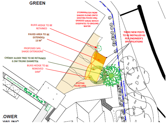
Figure
5: Site plan
showing the proposed works.
|
SECTION
4.15 ASSESSMENT
The following assessment is
provided against the relevant provisions of Section 4.15 of the Environmental
Planning and Assessment Act, 1979:
Local Environmental Plan 2009 (Section 4.15(1)(a)(i))
|
Zoning:
|
RE1 Public Recreation. The proposal is
consistent with the zone objectives.
|
|
Permissibility:
|
The proposed development forms part of
the continued use of the Longueville Sports Club as a community facility, recreation
facility (outdoor) and restaurant, all of which are permissible with consent
in the RE1 Public Recreation zone.
|
Lane Cove Comprehensive DCP 2010
There are no
applicable controls under LCDCP 2010. As such a merit-based assessment is
applied, as follows:
· The proposal is consistent with the
relevant objectives for the DCP contained in clause 1.1:
The
proposal will support the locality’s sustainability in environmental,
social, and economic terms by enhancing the amenity of the community facility/restaurant
/recreation facility (outdoor) for patrons.
The
design of the proposal will not detract from the visual quality of the
surrounding area and its relationship with the adjoining public domain.
The
proposal will provide for enhanced sun protection.
· The proposal does not involve any tree
removal. A draft condition is included to protect an existing mature Cherry
Alder Tree during construction works. The three (3) structural poles
of 120mm diameter will not encroach within 4m of the tree.
· The proposal has been skillfully
designed to be integrated with the existing sail structure.
· The proposal is not considered to give
rise to any adverse environmental impacts. The site is located on a corner
allotment with the works appropriately setback from the road frontage. No
additional seating or restaurant capacity is sought as part of this
application.
· The extended shade structure and
associated paving will enhance the amenity of an existing outdoor area used by
the sporting club and restaurant. The proposal is not considered to generate
any additional noise impact beyond the existing facilities.
· The additional paved area of 29m²
and associated removal of an existing Buxus hedge and grassed area will not
impact upon use of the recreational (outdoor) areas of the site.
Therefore,
the proposal is acceptable on merit.
Part Q:
Waste Management and Minimisation
The
submission of a Waste Management Form is exempt for the proposed works.
Part O:
Stormwater Management
A drainage plan has not been submitted with the
DA package. The site analysis plan indicates that stormwater from the shade
sails will flow onto existing paved and grassed areas and dissipate to ground
water.
Community
Land Plan of Management (Adopted 21 October 2019)
The Lane Cove
Council Community Land Plan of Management covers management of Central
Park, which includes 243 and 245 Longueville Road, owned by the Council. The
site is categorised within the Plan of Management as ‘general community
use’.
The proposal is
consistent with the objectives, land use and desired outcomes of the Plan of
Management as it allows for the continued/well-managed use of the site for a
community purpose associated with the Longueville Sporting Club that is
compatible with adjoining land uses.
REFERRALS
Development Engineer
No objections
subject to recommended draft conditions.
Tree
Preservation Officer
No objections subject to recommended draft
conditions. Consent is given for minor pruning and encroachment of the Tree
Protection Zone (TPZ) of an existing Syzygium leuhmannii tree
at the front of the site from the installation of shade cloth footings and
minor pruning.
APPLICABLE REGULATIONS
Section 61(1) of
the Environmental Planning and Assessment Regulation 2021 requires the
consent authority to consider the Australian Standard AS 2601-2001: The
Demolition of Structures. As the proposal involves removal of landscaped
area, compliance with AS2601-2001 is included as a draft condition.
LIKELY
IMPACTS OF THE DEVELOPMENT (Section 4.15(1)(b))
The impacts of the development
have been considered. The proposal is not considered to give rise to any
adverse environmental, social or economic impacts. Draft conditions are
included to require:
· Protection
of the existing Cherry Alder tree in accordance with AS 4970-2009 The
protection of Trees on Development Sites.
· The
shade cloth to be affixed in accordance with professional engineer’s
specifications and certification prior to issue of the occupation certificate.
· The
shade structure to be constructed from a non-combustible
material.
· Outdoor lighting to comply with Australian Standard AS 4282-1997
– Control of the obtrusive effects of outdoor lighting.
· No obstruction including stockpiling of materials of the public
pathway.
SUITABILITY OF THE SITE (Section 4.15(1)(b))
The proposal
is suitable for the site and will improve the amenity of the existing community
facility for club members and members of the public.
RESPONSE
TO NOTIFICATION (Section 4.15C(1)(d))
The
application was notified in accordance with Council’s Community
Participation Plan 2019 from 24 April to 9 May 2023. No submissions were
received.
CONCLUSION
The matters in
relation to Section 4.15 of the Environmental Planning and Assessment Act 1979
have been satisfied.
The application
is acceptable regarding the Lane Cove LEP 2009, the Lane Cove DCP 2010
and the Lane Cove Community Land Plan of Management 2019. The
proposal will improve the amenity of an
existing community facility for patrons.
On balance, the
proposed development would be reasonable and is therefore recommended for
approval.
|
RECOMMENDATION
That pursuant
to Section 4.16(1) of the Environmental Planning and Assessment Act, 1979 the
Lane Cove Local Planning Panel at its meeting of 5 July 2023, exercising the
functions of Council as the consent authority, grant consent to Development
Application 39/2023 for extension to an existing
shade cloth and associated works – Longueville Sporting Club at 243
Longueville Road, Longueville, subject to the
following conditions:
PART A – GENERAL CONDITIONS
1. A.1 -
Approved plans and supporting documentation
Development must be carried out in accordance with the following
approved plans and supporting
documentation (stamped by Council), except where the conditions of this consent
expressly require otherwise.
|
Plan No
|
Plan Title
|
Drawn By
|
Dated
|
|
A.01
|
Full Site Plan
|
Officepoint Drafting
|
15/03/2023
|
|
A.03
|
Site Analysis Plan
|
28/03/2023
|
|
A.04
|
South Elevation
|
14/03/2023
|
|
A.05
|
North Elevation
|
14/03/2023
|
|
A.06
|
Landscaping Plan
|
28/03/2023
|
|
Document Title
|
Version No.
|
Prepared By.
|
Dated
|
|
Statement of Environmental Effects
|
-
|
-
|
April 2023
|
In the event of any inconsistency between the approved plans and
the supporting documentation, the approved plans prevail. In the event of any
inconsistency between the approved plans and any condition(s) of this
consent, the condition(s) prevails.
Note: An inconsistency occurs between
an approved plan and supporting documentation or between an approved plan and
a condition when it is not possible to comply with both at the relevant time.
Reason: To
ensure all parties are aware of the approved plans and supporting
documentation that applies to the development.
2. A.3 - Payment
of security deposits (if applicable)
Before the commencement of any works on the site or the issue of a
construction certificate, the applicant must make all of the following
payments to Council and provide written evidence of these payments to the
Certifier:
|
Security deposit
|
Revision
|
|
Infrastructure Damage Bond
|
$4,000.00
|
A $4000.00 cash bond or bank guarantee
shall be lodged with Council to cover any infrastructure damage.
The payments will be used for the cost
of:
· making good any damage caused to any
council property (including street trees) as a consequence of carrying out
the works to which the consent relates,
· completing any public work such as
roadwork, kerbing and guttering, footway construction, stormwater drainage
and environmental controls, required in connection with this consent, and
Reason: To ensure any damage to public infrastructure is rectified
and public works can be completed.
3. A.7.L Tree
preservation and approved landscaping works
All landscape works shall be undertaken in accordance with the
approved landscape plan,
The protection of trees in Lane Cove is
regulated under the State Environmental Planning Policy (Biodiversity and
Conservation) 2021 (SEPP) parts 2.2 and 2.3 which prohibits the clearing of
vegetation without the authority conferred by a permit granted by Council.
Clearing under the SEPP is defined as:
a) cut down, fell, uproot, kill,
poison, ringbark, burn or otherwise destroy the vegetation, or
b) lop or otherwise remove a
substantial part of the vegetation.
The clearing of trees or vegetation protected by the regulation is
an offence against the Environmental Planning and Assessment Act 1979 (NSW).
The maximum penalty that may be imposed in respect to any such
offence is $1,100,000 per individual and $5, 500,000 per corporation.
The
following trees shall be retained:
|
Tree No.
|
Species
|
Location
|
Dimension
(metres)
|
|
1
|
Syzygium
leuhmannii
|
Front of property
|
8 x 8
|
This consent gives approval to carry out the following works in
Tree Protection Zones:
|
Tree No.
|
Species
|
Location
|
Permitted
works in TPZ
|
|
1
|
Syzygium leuhmannii
|
Front of property
|
Installation of
shade cloth footings, minor pruning
|
No Trees are to be removed as part
of this consent.
Reason: To
ensure the protection of trees to be retained and to confirm trees removed
for pruning/removal.
4. No building
or demolition works prior to release of construction certificate
The building work, or demolition work, must not commence until:
a) A Construction Certificate has been
obtained from the Council or an Accredited Certifier in accordance with the Environmental
Planning and Assessment Act, 1979.
b) A Principal Certifying Authority has
been appointed and Council has been notified of the appointment in accordance
with the EP&A Act 1979 and the EP&A Regulation 2021.
c) Council is given at least two
days’ notice in writing of the intention to commence the building
works.
Reason:
Statutory requirement.
5. Shade
structure material
The shade
structure shall be constructed from a non-combustible material.
Reason: To
mitigate fire risk.
PART B – PRIOR TO DEMOLITION
WORKS
6. B.3.EH
Compliance with demolition standard
Demolition of buildings and structures must comply with Australian
Standard AS 2601—2001: The Demolition of Structures.
Reason: Prescribed condition under EP&A Regulation 2021.
7. B.14
- Special Condition - Tree Protection Measures Fencing
The following tree protection measures must be in place prior to
demolition works and certified by the project arborist.
Tree Protection Fencing must be installed within the following
locations:
1. Offset 2m form
the trunk of T1 to protect root system and trunk of tree
The fencing must consist of a 1.8 m high chain mesh fence held in
place with concrete block footings and fastened together. An example of
fencing is shown under figure 3 on page 16 of the Australian Standard
4970-2009 The Protection of Trees on Development. The fenced area shall not
be used for the storage of building materials, machinery, site sheds, or for
advertising and the soil levels within the fenced area shall remain
undisturbed.
A waterproof sign must be placed on every second panel stating,
‘NO ENTRY TREE PROTECTION AREA – this fence and sign are not to
be removed or relocated for the work duration.’ The minimum size of the
sign is to be A3 portrait with NO ENTRY TREE PROTECTION ZONE in capital Arial
Font size 100, and the rest of the text in Arial font size 65.
Such fencing and signage must be erected Prior to Demolition
including site preparation and remain in place for the duration of the
construction work
Movement of Tree Protection Fencing must be overseen and approved
by the project Arborist with notification provided to Council’s Tree
Management Officer in writing.
Reason: To protect the
natural environment.
PART C - BEFORE THE ISSUE OF A
CONSTRUCTION CERTIFICATE
8. C.1 –
Construction site management plan
Prior to any works and before the issue of a construction
certificate, the applicant must ensure a construction site management plan is
prepared before it is provided to and approved by the certifier. The plan
must include the following matters:
a) location and materials for protective
fencing and hoardings to the perimeter of the site
b) location and materials for
protective fencing and hoardings to the perimeter on
the site.
c) provisions for public safety
d) pedestrian access, including
disabled and pram access, is to be maintained throughout the course of the
construction as per AS-1742.3, ’Part 3 - Traffic control devices for
works on roads’
e) pedestrian and vehicular site access
points and construction activity zones
f) location of site storage areas
and sheds
g) equipment used to carry out all work
h) a garbage container with a tight-fitting lid
i) protective measures for on-site tree
preservation (including in accordance with AS 4970-2009 Protection of trees
on development sites
The applicant
must ensure a copy of the approved construction site management plan is kept
on-site at all times during construction.
Council
Approvals
· Where
hoarding is required to be provided along the street frontage, a Hoarding
Application is to be submitted to Council for approval.
· Any construction
plant on the public road reservation requires an approved “Application
for standing plant permit”
Reason: To require details of measures that will protect the
public, and the surrounding environment, during site works and construction.
9. C.2 - Erosion
and sediment control plan
Prior to any demolition works or clearing of any vegetation and
before the issue of a construction certificate, the applicant is to ensure
that an erosion and sediment control plan is prepared in accordance with the
following documents before it is provided to and approved by the certifier:
· Council’s
development control plan,
· the guidelines
set out in the NSW Department of Housing manual ‘Managing Urban
Stormwater: Soils and Construction Certificate’ (the Blue Book), and
· the ‘Do it
Right On-Site, Soil and Water Management for the Construction Industry'
(Southern Sydney Regional Organisation of Councils and the Natural Heritage
Trust).
The applicant must ensure the erosion and sediment control plan is
kept on- site at all times during site works and construction.
10. C.24.E - Structural
engineer’s details
The shade cloth is to be affixed in accordance with professional
engineer’s specifications with details included on the construction
certificate documentation.
Reason: To ensure the structural integrity of the extended shade
cloth.
PART D
– BEFORE THE COMMENCEMENT OF BUILDING WORK (INCLUDING DEMOLITION)
11. D.1 - Erosion and
sediment controls in place
Before the commencement of any site or demolition works, the
principal certifier must be satisfied the erosion and sediment controls in
the erosion and sediment control plan, (as approved by the principal
certifier) are in place until the site is rectified (at least 70% ground
cover achieved over any bare ground on site).
Reason: To ensure runoff and site debris do not impact local
stormwater systems and waterways.
12. D.2 - Tree protection
measures
Before the commencement of any demolition works, the principal
certifier must ensure the measures for tree protection detailed in the
construction site management plan are in place. Tree protection measures
shall comply with AS4970-2009 – Protection of trees on development
sites.
Reason: To
retail and protect trees on the site.
13. D.3 - Signs on site
A sign must be erected in a prominent position on any site on
which the building and demolition work is being carried out:
a) showing the name,
address and telephone number of the principal certifier for the work, and
b) showing the name of the principal contractor (if any)
for any building work and a telephone number on which that person may be
contacted outside working hours, and
c) stating that unauthorised entry to the work site is
prohibited.
Any such sign is to be maintained while the building work or
demolition work is being carried out but must be removed when the work has
been completed.
Note: This does not apply in relation
to building work or demolition work that is carried out inside an existing
building that does not affect the external walls of the building.
Reason: Prescribed condition EP&A Regulation, clauses 98A (2)
and (3).
PART E: CONDITIONS
TO BE COMPLIED WITH WHILE WORKS ARE BEING CARRIED OUT
14. E.1 - Hours of work
The principal certifier must ensure that building work, demolition
or vegetation removal is only carried out between:
Monday to Friday (inclusive) 7am
to 5.30pm
Saturday 7am
to 4.00pm
Sunday and public holidays No
works permitted
A Notice/Sign showing permitted working hours and types of work
permitted during those hours, including the applicant’s phone number,
project manager or site foreman, shall be displayed at the front of the site.
The principal certifier must ensure demolition is not carried out
on Sundays and public holidays, except where there is an emergency.
Unless otherwise approved within a construction site management
plan, demolition/construction vehicles, machinery, goods, or materials must
not be delivered to the site outside the approved hours.
Note: Any variation to the hours of
work requires Council’s approval.
Reason: To protect the amenity of the surrounding area.
15. E.2 - Compliance with
the Building Code of Australia
All works must comply with the requirements of the Building
Code of Australia.
16. E.8 - Tree protection
While demolition and building work is being carried out, the
applicant must maintain all required tree protection measures in good
condition in accordance with the construction site management plan required
under this consent, the relevant requirements of AS 4970-2009 Protection
of trees on development sites, any arborist’s report approved under
this consent and conditions B14, B15 and B16. This includes maintaining
adequate soil grades and ensuring all machinery, builders refuse, spoil and
materials remain outside tree protection zones.
Reason: To
protect trees during demolition works.
17. E.25
– Stockpiling of Materials
No
stockpiling of materials, building equipment or additional activities listed
in section 4.2 of AS4970-2009 The Protection of trees on Development Sites
is to occur within designated tree protection areas or on the Council
Owned Nature Strip. All building materials must be stored within the subject
site.
Reason: To mitigate damage
to Council land.
18. E.26 – Tree
Pruning
No
stockpiling of materials, building equipment or additional activities listed
in section 4.2 of AS4970-2009 The Protection of trees on Development Sites
is to occur within designated tree protection areas or on the Council
Owned Nature Strip. All building materials must be stored within the subject
site
Council
grants consent for the pruning of Tree #1 Syzygium leuhmannii at the
front of the property. Pruning is to consist of the following:
Selective
prune of 2nd and 3rd order branches to achieve adequate branch clearance for
the newly erected shade structure. Final cuts <60mm diameter at branch
junctions with 10% live foliage to be removed
All pruning
works must be done in accordance with AS4373-2007 The Pruning of Amenity
Trees. All branches must be pruned to branch collars to the specified branch
diameters listed above.
Works may
only be undertaken Upon issue of a construction certificate. Pruning outside
of the authorised works will result in regulatory action.
Reason:
To provide appropriate construction clearances whilst maintaining health and
aesthetic of tree.
19. E.18.B - No obstruction
of public way
The public way must not be obstructed by any materials, vehicles,
refuse, skips or the like, under any circumstances. Non-compliance with this
requirement will result in the issue of a notice by Council to stop all work
on site.
Reason: To
ensure public safety.
20. E.20.EH –
Stockpiles
Stockpiles of topsoil, sand, aggregate, spoil or other material
capable of being moved by water to be stored clear of any drainage line,
easement, natural watercourse, footpath, kerb or roadside.
Reason: To mitigate adverse environmental impacts on the
surrounding area.
PART F
– BEFORE THE ISSUE OF AN OCCUPATION CERTIFICATE
21. F.1 – Structural
Engineer Certification
Before the issue of the relevant occupation certificate, the
applicant must submit, to the satisfaction of the principal certifier, a
compliance certificate that the proposed shade structure has been constructed
in accordance with the professional structural engineer’s
specifications.
Reason: To ensure the structural integrity of the works to the
public community facility.
22. F.7 - Completion of
landscape and tree works
Before the issue of an occupation certificate, the principal
certifier must be satisfied that all landscape works (paving), including
protection of the Cherry Alder tree, have been completed in accordance with
the approved plans and any relevant conditions of this consent.
Reason: To ensure the approved landscaping works and tree
protection in accordance with this consent.
23. F.13.EH - Outdoor
lighting
Outdoor lighting shall comply with Australian Standard AS
4282-1997 – Control of the obtrusive effects of outdoor lighting.
|
ATTACHMENTS:
There are no supporting documents for this report.
Lane Cove Local Planning Panel Meeting 05 July
2023
5 Mary Street,
Longueville
Subject: 5
Mary Street, Longueville
Record No: DA23/25-01 - 33471/23
Division: Environmental
Services Division
Author(s): Andrew
Thomas
|
Property:
|
5 Mary Street, Longueville
|
|
DA No:
|
D25/23
|
|
Date Lodged:
|
23.3.23
|
|
Cost of Work:
|
$3,500
|
|
Owner:
|
D. and S. and S. Petrovic
|
|
Applicant:
|
Dragoslav Petrovic
|
|
Description of the proposal to appear on
determination
|
The
re-subdivision (boundary adjustment) of two existing Torrens tile lots into
two equal-sized Torrens title lots.
|
|
Zone
|
R2 Low Density
Residential
|
|
Is the proposal permissible within the
zone
|
Yes
|
|
Is the property a heritage item
|
No
|
|
Is the property within a conservation
area
|
No
|
|
Is the property adjacent to bushland
|
No
|
|
BCA Classification
|
No
classification
|
|
Stop the Clock used
|
No
|
|
Notification
|
Neighbours 1,
3, 7 and 9 Mary Street and 2, 4, 6, 8, 10 and 10A Stuart Street.
Ward Councillors Central
Progress
Association Longueville
Residents Association.
Other
Lane Cove Historical Society.
|
REASON FOR
REFERRAL
Development
Application D25/23 is referred to the Lane Cove Local Planning Planal given the
concerns raised by neighbours and because the Applicant has lodged a deemed
refusal appeal in the Land and Environment Court (NSW).
EXECUTIVE
SUMMARY
· The subject site comprises two Torrens title lots: one lot has an
area of 695.6m2 and a frontage of 15.24m and the other lot has an
area of 418.1m2 and a frontage of 9.145m.
· The site is vacant.
· The application proposes to adjust the common side boundary of both
lots by about 3m to re-subdivide the site into two Torrens title lots of equal
size so that each proposed lot would have an area of 557.5m2 and a
frontage of 12.19m.
· Subdivision is permissible with consent under clause 2.6 of the Lane
Cove Local Environmental Plan 2009 (the LEP).
· The area of both proposed lots complies with the minimum lot size of
550m2 under the LEP.
· The width of both proposed lots does not comply with the minimum
frontage provision of 15m under the Lane Cove Development Control Plan 2009 (the
DCP).
· Seven submissions have been received in response to Council’s
notification of the application. In summary, the main concerns and issues
raised in these submissions are:
- the non-compliant width of both
proposed frontages;
- its impact on an adjoining
heritage item and a rear property;
- its impact on a shared
driveway;
- the applicant’s
motives; and
- its impact on
health.
· Council officers who have commented on the proposal have either
recommended conditions or raised no concerns. By
contrast, Council’s Heritage Adviser does
not support the proposal because:
- the narrow frontage proposed for each lot would be
below the DCP requirement;
- the area proposed for each lot would be
far less than lot sizes prevailing in Mary Street and elsewhere in
Longueville; and
- of its unacceptable impact on an adjoining
residential property that is a heritage item under the LEP.
· The proposal would result in two equal-sized lots that would create
the potential for a better development outcome on the site and for adjoining
and adjacent property owners.
· The proposed application is recommended for approval subject to
conditions.
SITE
|
Property
|
The subject
site comprises Lot 5, DP 5795 and Lot 1, DP 1093439.
|
|
Area
|
The combined
area of both existing lots is 1,115m2 (see the later subheading Proposal).
|
|
Site location
|
The site is
located on the high, north side of Mary Street and about 70m from this
street’s intersection with Stuart Street to the east.
|
|
Existing improvements
|
When this
development application was lodged there was a single storey dwelling house
that straddled both lots and a combined detached carport and garage on the
site’s smaller eastern lot. These structures were demolished in May
2023. The site is currently vacant.
|
|
Shape
|
Each existing
lot is a regular rectangle.
|
|
Dimensions
|
Lot 5, DP 5795
has a width of 15.24m and a depth of 45.72m
Lot 1, DP
1093439 has a width of 9.145m and a depth of
45.72m.
|
|
Adjoining properties
|
Adjoining
properties are dwelling houses. The adjoining property on the west side of
the site, at 7 Mary Street, is a heritage item of local significance under
the LEP. The locality is generally residential. Opposite the site, on the
lower southern side of Mary Street, is a Council reserve known as Aquatic
Park.
|
PREVIOUS APPROVALS/HISTORY
The most recent
approval on the site has been a complying development certificate issued in
February 2023 by a certifier for the demolition of all its existing structures
(CDC 26/23).
Council’s
computer system has no record of any other development approval, or any other
development history, for the site.
PROPOSAL
|
The application for re-subdivision proposes to
adjust the common side boundary of the site’s existing two Torrens tile
lots to create two equal-sized Torrens title lots. The following table
compares the existing and proposed site area and frontage of each existing
and each proposed lot.
|
Existing lot
|
Proposed lot
|
|
(i) Site area
Lot
5, DP 5795 : 695.6m2
Lot
1, DP 1093439 : 418.1m2
|
(i) Site area
Lot 1 : 557.5m2
Lot
2 : 557.5m2
|
|
(ii) Frontage
Lot
5, DP 5795 : 15.24m
Lot
1, DP 1093439 : 9.145m
|
(ii) Frontage
Lot
1 : 12.19m
Lot
2 : 12.19m
|
From the areas shown in the table above:
· the two existing lots have a combined area of 1,113.7m2
· the two proposed lots have a combined area of 1,115m2
· the difference in the total area of both lots is 1.3m2.
To address the difference of 1.3m2
between the total area of both lots the Applicant has confirmed that:
· the existing Lot 5, DP 579 has an area in perches that is 695.6m2
· taking its survey dimensions
of 15.24m x 45.72m, this same lot has an area of 696.77m2
· based on the survey, the total area
of both existing lots is 1,114.87m2 (696.77m2 + 418.1m2)
and rounded up this gives a total area for both proposed lots of 1,115m2
(557.5m2 + 557.5m2).
From the frontage dimensions shown in the table
above the common side boundary of both existing lots is proposed to be moved
3.05m to the west.
|
PROPOSAL
DATA/COMPLIANCE
Lane Cove Local Environmental Plan 2009
(the LEP)
Zoning: R2 Low Density
Combined site area: 1,115m²
|
Existing lot
|
Existing area
|
Proposed lot and its area
|
Minimum
subdivision lot size
|
Complies
|
|
Lot
5, DP 5795
|
695.6m2
|
Lot
1: 557.5m2
|
550m2
|
Yes
|
|
Lot
1, DP 1093439
|
418.1m2
|
Lot
2: 557.5m2
|
550m2
|
Yes
|
Lane Cove Development Control Plan 2009:
Part C.4 Residential Subdivision - Dwelling Houses (the DCP)
|
Existing lot
|
Existing frontage
|
Proposed lot and its frontage
|
Provision:
minimum frontage
|
Complies
|
|
Lot
5, DP 5795
|
15.24m
|
Lot 1: 12.19m
|
15m
|
No
|
|
Lot
1, DP 1093439
|
9.145m
|
Lot 2: 12.19m
|
15m
|
No
|
The tables above confirm that:
· the area and frontage of the existing
smaller lot does not comply with the LEP and DCP, respectively;
· the area of both proposed lots
complies with minimum lot size under the LEP; and
· the frontage of both proposed lots
does not comply with the DCP.
REFERRALS
Heritage Adviser
Has advised
that:
· the proposal includes schematic designs for a pair of two storey
infill dwellings ……which are proposed for construction following
clearing of the site;
· 7 Mary Street is a heritage item of local heritage significance
under the LEP that includes an intact timber Queenslander style Federation
elevated residence;
· the proposed infill development will
have considerable impact on this heritage building;
· Longueville is characterised by large late Victorian-early
Federation period buildings;
· 7 Mary Street is unusual as a surviving timber building of the
period with exceptional design features and joinery detailing;
· the subdivision pattern of Mary Street is large allotment sizes,
typically greater than 20 metre street frontages;
· the proposed subdivision results in two frontages of less than the
code requirement and far less than lot sizes prevailing in Mary Street and
elsewhere in Longueville;
· the proposed development of two closely spaced two storey residences
will have an unacceptable impact not only on the adjacent heritage item, but
also on the existing streetscape;
· …the development is inappropriate in this location adjacent
to a heritage item and in the context of the heritage character and subdivision
pattern of Longueville;
· therefore I am unable to support the proposed
development in its present form.
Comment
The proposed
re-subdivision involving the adjustment of the common side boundary of both
existing lots does not involve any physical works.
The
documentation submitted with this application includes concept plans for a two
storey dwelling house with attached parking on each proposed lot. These plans
show compliance with both the height and floor space ratio standards under the Lane
Cove LEP 2009 (the LEP) and relevant numerical provisions of the Lane
Cove DCP 2009 (the DCP) and may have been submitted to address a
requirement under Part C.4 Residential Subdivision - Dwelling Houses of
this DCP.
Whilst some of
the potential impact of the proposed re-subdivision is illustrated in these
concept plans, the full impact cannot be assessed until a development
application is lodged for a dwelling house on either of the proposed two lots.
However, since both lots also have the potential for a two storey dwelling
house as complying development under State Environmental Planning Policy
(Exempt and Complying Development Codes) 2008 (the SEPP), this
impact would not be a consideration. The Applicant has confirmed that under
this SEPP a two storey dwelling house could be constructed on each existing lot
with a gross floor area about 25m2 less (on the smaller eastern lot)
and about 56m2 more (on the larger western lot) than the maximum
gross floor area permitted on each proposed lot under the LEP.
There would be
no discernible impact from the proposed re-subdivision of the site’s
existing two lots into the two proposed lots.
The impact on
this adjoining heritage item would be a matter for consideration if a
development application was submitted for a dwelling house on the proposed
adjoining western Lot 1.
However, the
owner of each proposed lot also has the potential to construct a dwelling house
on that lot under the SEPP. If this approach is taken the impact of such
development on the adjoining heritage item would not be a matter of
consideration.
Development Engineer
Has recommended
a condition to address the documentation required for the proposed subdivision.
Development Engineer - Traffic
Has confirmed that:
· the
shared driveway is predominantly (if not entirely) on the road reserve;
however, under Section 218 of the Roads Act 1993, the landowner or
occupier is responsible for the construction and repair of a driveway servicing
their property; and
· as part of an assessment of a development application for a dwelling
house on each proposed lot, a condition would be imposed requiring the forward
entry and exit to each property.
Tree Officer
Has confirmed
that as no works are proposed no tree-related conditions are required.
ASSESSMENT - ENVIRONMENTAL PLANNING AND
ASSESSMENT ACT, 1979
Section 4.15 (1)(a)(i) The provisions of any
environmental planning instrument
The two
environmental planning instruments relevant to the assessment of this
application are addressed under the respective subheadings that follow.
1. Lane Cove
Local Environmental Plan 2009 (the LEP)
General
In relation to
the LEP the proposed re-subdivision:
· is permissible with consent under clause 2.6;
· satisfies the relevant objectives of the R2 zone (see subheading (i)
below);
· satisfies the minimum subdivision lot size of 550m2 under
cl. 4.1(3) (see sub-heading (ii) below);
· would have no impact on the heritage significance of the adjoining
property at 7 Mary Street (see subheading (iii) below); and
· does not raise any other issues in relation to the LEP.
(i) Zone objectives
The site is in Zone R2 Low Density Residential under the LEP.
Of the five objectives within this zone the following three are relevant to
this proposal:
· To provide for the housing needs of the community within a low
density residential environment.
· To retain, and where appropriate improve, the existing residential
amenity of a detached single family dwelling area.
· To ensure that landscaping is maintained and enhanced as a major
element in the residential environment.
Comment
The proposal would be consistent
with all three objectives because it would:
· maintain the area’s low density residential character;
· retain existing residential amenity for the residents of the
proposed western Lot 1 whilst improving residential amenity for the residents
of the proposed eastern Lot 2 compared to a dwelling house that could be built
on the existing smaller eastern lot; and
· maintain the site’s existing trees and enable both proposed
lots to be landscaped in the future.
(ii) Part 4 Principal development standards
Clause 4.1
Minimum subdivision lot size
The objective
under subclause (1)(a) is to promote consistent subdivision and
development patterns in zones.
Clause 4.1 (2) applies
to a subdivision of any land shown on the Lot Size Map.
Clause 4.1 (3)
states that the size of any lot resulting from a subdivision of land to
which this clause applies is not to be less than the minimum size shown on the Lot
Size Map in relation to that land which is 550m2. The proposal
would create two equal-sized Torrens title lots of 557.5m2.
Comment
With a site area
of 557.5m2 both proposed lots comply with the minimum lot size.
In addition, the
proposed re-subdivision would be consistent with the current subdivision pattern
as the site would continue to comprise two Torrens title lots orientated
north-south.
(iii) Part 5
Miscellaneous provisions
Clause 5.10
Heritage conservation
Objectives
The relevant
objectives of subclause (1) are:
(a) to conserve the environmental heritage
of Lane Cove,
(b) to conserve the heritage significance of
heritage items and heritage conservation areas, including associated fabric,
settings and views.
Comment
The suburb of Longueville
is not a conservation area.
7 Mary Street is
a heritage item under the LEP (heritage reference I248) and adjoins the
site’s western side boundary. A copy of Council’s heritage listing
for this site is attachment AT-1. In summary, Council’s heritage listing states that:
· the property is of local heritage significance;
· its Federation cottage was built at the turn of the 20th
century; and
· it retains its contemporary garden.
The proposed
re-subdivision of the site would not be contrary to either of these objectives
because it would have no impact on this adjoining heritage item.
Under subclause
(5) Council may …….on land that is within the vicinity of a
heritage item require a heritage management document to be prepared that
assesses the extent to which the carrying out of the proposed development would
affect the heritage significance of the heritage item….concerned.
In addition,
under Part B.9 Heritage of the Lane Cove DCP 2009, Council can
require a Heritage Impact Statement to be prepared as part of any DA
for development “ in the vicinity of a heritage item”.
The impact on
the heritage significance of this same adjoining property would be a matter for
consideration if a development application is submitted to Council for
development on either of the proposed two lots and particularly development on
the proposed western Lot 1.
Consequently,
the proposed re-subdivision does not raise any issues regarding the LEP.
2. State
Environmental Planning Policy (Biodiversity and Conservation) 2021 (SEPP)
Chapter 6
Water catchments of this SEPP includes land within
the Sydney Harbour Catchment.
Although the
site is within this catchment, the proposed re-subdivision does not raise any
issue in relation to this SEPP. The assessment and potential impact of future
development on Sydney Harbour Catchment would be a matter for
consideration if a development application was submitted for development on
either of the two proposed lots.
Section 4.15 (1)(a)(ii) The provisions of any draft
environmental planning instrument.
There is no
draft environmental planning instrument relevant to this application.
Section 4.15 (1)(a)(iii) The provisions of any
development control plan
The two
development control plans that apply to the assessment of this application are
addressed under the respective subheadings that follow.
1. The Lane
Cove Development Control Plan 2009 (the DCP)
The proposed
development has been assessed against the objectives and provisions of the DCP
that are addressed under the following subheadings.
Part C
Residential Development
Part C of the
DCP sets out the objectives and provisions for Residential Development and
Part C.4 addresses both aspects in relation to subdivision.
C.4
Residential Subdivision - Dwelling Houses
The objectives
and provisions relating to residential subdivision are addressed below.
Objectives
The objectives
for residential subdivision are to:
1. Protect amenity while permitting
the subdivision of lots in environmentally sensitive areas or where significant
impacts on neighbours are likely and careful design is required to minimize
those impacts.
2. Allow residential Torrens Title
subdivision which retains, and where appropriate, improves existing amenity and
streetscape within residential zones.
Comment
The proposed
re-subdivision of the site does not raise any issue regarding these two
objectives because:
· the site is not in an environmentally sensitive area and the
minimisation of any significant impacts through design is not a relevant
matter under this assessment; and
· existing amenity would not change; however, existing amenity would
be more likely to be improved on the proposed eastern Lot 2 because it would
have a significantly larger area relative to the area of the existing
undersized lot on the site’s eastern side; in addition, whilst
streetscape would also not change, the visual impact of development on either
of the two proposed lots viewed from Mary Street would be reduced by the
vegetation along the shared driveway serving the site and adjoining sites and
by the restricted line of sight caused by the rock embankment supporting this
driveway, whilst opposite the site, on the southern side of Mary Street,
pedestrian views of the site are restricted from the section of the street
where there are parked boat trailers and no
footpath.
Provisions
The provisions
relevant to the proposed re-subdivision of the site are addressed below.
a)
Constraints on development
Subclause a) of
the DCP states that (W)here a development application is proposed for
residential subdivision …..where significant impacts on neighbours are
likely and careful design is required to minimize those impacts, Council may
impose conditions providing constraints on future buildings that include, but
are not limited to, a prescription of:
· its maximum height
· its building envelope or location, or
· its design, and
such
constraints may include the placement of an appropriate covenant….
Comment
As addressed
under an earlier subheading in relation clause 5.10 Heritage conservation
of the LEP, the proposed re-subdivision would have no impacts on neighbours,
including the owners of the heritage item at 7 Mary Street that adjoins the
site’s western side boundary and the owners of the residential property
at 3 Mary Street that adjoins the site’s eastern side boundary.
In addition, as
the proposal would re-subdivide the site’s existing two lots, meet the
minimum lot size requirement of the LEP and retain its existing north-south
orientation, there would be no impact on the owners of the residential
properties at the rear of the site in Stuart Street.
b) Minimum
frontage (allotment width at street)
Under subclause
c) a minimum frontage of 15m is required.
Comment
The proposed
re-subdivision would create two lots of equal size compliant with the LEP
minimum lot size of 550m2. However, the proposed 12.19m
frontage of each lot would be less than the DCP requirement of 15m.
However, the
proposed frontage is reasonable given that the proposed development is a better
planning outcome as the subdivision would be consistent with the existing
subdivision pattern. By proposing to make each existing lot the same in both
its area and frontage a potentially better outcome on adjoining properties
could be achieved.
c) Driveway
width
Subclause d)
states that the minimum width for a driveway serving a battle-axe allotment is
3m and should be designed to ensure that vehicles can enter and leave
the proposed lot/s in a forward direction.
Comment
Although the
proposed re-subdivision would not create a battle-axe allotment,
Council’s Development Engineer - Traffic has confirmed that under a
development application a condition of consent would require vehicles to enter
and leave both proposed lots in a forward direction.
d) Direct
access
Subclause e)
states that a battle-axe lot must have direct access to a dedicated public
road through the provision of an access handle attached to that lot, or via an
access corridor shared by such lots.
Comment
Whilst the
proposed re-subdivision would not create a battle-axe allotment,
Council’s Development Engineer -Traffic has confirmed the shared driveway
provides access to the site and to 3, 7 and 9 Mary Street, and that this
driveway ensures each lot has direct access to Mary Street.
2. Sydney
Harbour Foreshores and Waterways Area Development Control Plan 2005 (DCP 2005)
DCP 2005
accompanies the Foreshores and Waterways Area controls under Chapter
6 Water catchments of the SEPP (Biodiversity and Conservation) 2021
that was addressed under point 2 of the earlier subheading Section 4.15(1)(a)(i) Any environmental planning
instrument.
As no physical
works are required under the proposed re-subdivision, the proposal does not
raise any issues regarding either:
· the site and/or this area’s landscape character type under
part 3 Landscape Assessment; or
· the appearance of any building under part 5 Design Guidelines for
Land-Based Developments,
or any other
part of this DCP.
Section 4.15 (1)(a)(iv) The provisions of the
applicable regulations
The proposed
re-subdivision does not raise any issues in relation to the Environmental
Planning and Assessment Regulation 2021.
Since this
development application was lodged with Council the dwelling house and parking
structures that existed on the site have been demolished under a CDC approved
by the Applicant’s own certifier.
Section 4.15 (1)(b) The likely
impacts
Built environment
The proposed re-subdivision of the site’s
existing two lots would have no impact on the built environment.
Natural environment
The proposed re-subdivision of the site’s
existing two lots would have no impact on the natural environment.
Section 4.15 (1)(c) The suitability of the
site
The site has been used for residential purposes
for many years and as it is not bush fire prone land, nor affected by any
natural hazard, it remains suitable for the re-subdivision proposed.
Section 4.15 (1)(d) Any submissions made
Seven submissions have been received in response
to Council’s notification of the proposal: four submissions were received
from the owners of properties adjoining the site at 3 and 7 (two separate
submissions) Mary Street and 4 Stuart Street and three from the owners of
properties close to the site at 1, 9 and 11 Mary Street. A summary of the
concerns and issues raised in these submissions and a comment on the
submissions follows.
1.
Frontage
Understood that a 15m frontage in Longueville was
mandatory.
Each proposed street frontage is significantly
below the minimum requirement of 15m and will set a bad precedent for
the area.
The 15m minimum frontage is etched in town
planning since the creation of Longueville - most blocks subdivided
at Longueville Point in 1905 had a 50-foot frontage (15.24m) and this was
consistent……... throughout Longueville.
The existing smaller eastern lot once formed part
of a lot that had a 40-foot frontage to facilitate the corner position and
access to an adjoining lot; in 1922 it was divided into two with a parcel
10 feet wide attached to this same adjoining lot and the remaining 30 feet
frontage sold together with an adjoining lot to create 5 May Street. With only
a 30-foot frontage it is difficult to envisage that there was a town
planning intention that this residual lot would accommodate a house,
or that the combined lot forming this site was intended to at any
point in time able to accommodate two houses, as is now proposed.
Examples of narrower blocks are provided in the
SEE but these:
· are not comparable: one is a corner
block, another is a battle-axe block and none are as narrow or side by side;
· seem to be isolated and with no example of two adjoining
narrow blocks less than 15m in width, nor any example of two adjoining narrow
blocks (that would each have a narrow house) bordering a heritage
property.
Examples of variations to the minimum frontage are
not common.
Two narrow and apparently similar dwellings
will be a radical departure from character and streetscape in
the locality.
The site is only appropriate for one dwelling.
Comment
There is no mandatory frontage. The 15m minimum
frontage under the Lane Cove DCP is a provision. Where a provision
cannot be met Council would review a proposal against the relevant objectives
of this same DCP.
The design of the dwelling house on each proposed
lot is a mirror reverse of the other and is only a concept to show a dwelling
house that complies with Council’s relevant controls could be constructed
on each lot.
2. Impacts
(i) Heritage
The impact on the heritage item at 7 Mary Street
does not appear to have been addressed in the proposal. How would the
proposed subdivision and subsequent housing development impact this item?
This item’s heritage significance provides
for an open garden space, generous verandah and river views. Views include the
river and waterfront parkland from its front balcony, views of the river and
CBD from a side balcony and toward the Harbour Bridge and river from the
position of its original rear balcony and across the rear yard of the subject
site.
7 Mary Street is one of the few remaining
examples of a wooden home in Longueville and is possibly the one in its
most original form. A key feature is its sweeping verandah
designed to follow the Lane Cove River; the proposed subdivision would
inevitably result in two family-sized structures ….that would
significantly deplete this heritage feature; the property’s original name
Afton Water was named in homage to a Robert Burns poem which speaks
to the heritage empathy between home and the land worth preserving in Lane
Cove.
5 Mary Street is of heritage significance and
should remain so.
Comment
The proposed re-subdivision would have no impact
on the adjoining heritage item.
The concept housing plans show how each proposed
lot could support a dwelling house that would comply with Council’s
relevant controls.
The impact on views from the adjoining heritage
item across the rear yard of either of the proposed two lots would be assessed
if a development application was submitted for a dwelling house on either
of these two lots having regard to the planning
principles established in Tenacity Consulting v Warringah (Council) (2004)
NSWLEC 140. The proposed re-subdivision has no impact on existing views.
5 Mary Street is not a heritage item under the Lane
Cove LEP 2009. The heritage significance of 7 Mary Street is not threatened
by this proposed re-subdivision.
(ii) Hedges/trees
Would like to understand the applicant’s
intentions regarding the hedging (Murraya and Camellias) that act as
both a privacy and green fence along part of the common side boundary between 5
and 7 Mary Street and that serves very well with the garden and heritage
nature of 7 Mary Street but is not shown on the concept plans; in addition,
a cluster of three trees …… toward the boundary appear to
have been overlooked.
Comment
Both the hedging along the common boundary
between 5 and 7 Mary Street and the trees on the subject site have been
retained following the demolition of its dwelling house and car parking
structures.
(iii) Rear property (4 Stuart Street)
The impact of the proposed subdivision into
two very narrow blocks to accommodate two narrow houses does not
paper to have been addressed.
Of particular concern to our privacy is the
intention regarding three large trees at the rear of the block that provide shade and privacy to our
house and pool - please ensure these trees are retained.
Comment
The proposed re-subdivision would have no impact
on this adjoining property.
The trees towards the rear boundary of the
subject site have been retained following the demolition of its dwelling house
and car parking structures.
3. Shared driveway
3, 5 and 7 Mary Street are situated on a
sandstone outcrop that has deteriorated since the initial subdivision
that created these lots; deterioration may accelerate with ongoing
climate changes to rainfall patterns. Question the suitability and
wisdom of subdivision to permit two significant structures and their
interaction with water tables and runoff on an increasingly vulnerable base,
particularly because of the narrow driveway of questionable safety and
durability along the Council edge of the outcrop that is used by vehicles
accessing these same three sites. A further dwelling and associated traffic on
the outcrop, let alone the risk posed by construction vehicles, would
represent a significant additional risk and ultimately cost to Council.
Where only one car from the site used this driveway now there
could be easily 4 cars.
After the subdivision and future development, there
will be at least a 25% additional load and usage on the shared driveway;
has the applicant considered this additional load ?
Concerned if the driveway is damaged,
particularly during construction. Is the Council liable for any damage that
may occur ?
The only access to the site is extremely
narrow.
Demolition and construction vehicles will not
have adequate access, and will at times block free access to the
neighbours who use this driveway. Contractors cannot park on Mary Street to
gain access due to the local geography; the area is parked out by
boat trailers.
An existing high fence results in poor visibility
leaving 9 Mary Street and it is very difficult reversing from its
garage; I need understanding neighbours; worry about the safety of our
small grandchildren.
Comment
The subject site already comprises two lots on
which a dwelling house could be constructed on each lot. The proposed
re-subdivision would also allow a dwelling house to be built on each proposed
lot. The scale of any dwelling house on either of the two proposed lots and its
impact on the water table and on runoff is not a matter for consideration under
this application for re-subdivision.
The potential increase in traffic is a matter for
consideration when a dwelling house on each proposed lot is assessed under a
development application.
Council’s Development Engineer - Traffic
has advised that damage to the shared driveway is the responsibility of the
property owner who caused the damage.
The width of the shared driveway has proved
adequate for the other properties that use it for access.
The shared driveway has provided access to enable
the recent demolition of the dwelling house and car parking structures on the
subject site. Development works undertaken on adjoining properties would
also need to use this same shared driveway.
The visibility available to the residents of 9
Mary Street when reversing would remain their responsibility irrespective of
the re-subdivision of the subject site.
4. Applicant’s motives
The concept plans indicate an intention to
maximise the built environment on each proposed lot.
It would be reasonable to assume that granting
the subdivision would see an opportunistic attempt to make a super profit from
a recent purchase of land.
Request that the fabric of our area is
maintained and that this opportunistic grab for profit is
rejected.
Comment
The concept plans show that a two storey dwelling
house with attached parking that complies with Council’s relevant
controls could be constructed on both proposed lots.
If the re-subdivision of the site as proposed in
this application is approved, the owner could develop each lot under either
Council’s, or the State government’s, current controls, or sell
each lot and any profit made would be dependent on market forces.
The proposed re-subdivision of the existing two
lots would not alter the fabric of this part of Longueville.
5. Asbestos
There could be asbestos on the site; its removal will
likely disperse fibers……. and then affect occupants of
several neighbouring properties and visitors to nearby parks.
Comment
The recent demolition of the dwelling house and
car parking structures on the site appears to have occurred without causing a
health concern.
Section 4.15 (1)(e) The public interest
Council’s notification of this
application’s proposed re-subdivision of the subject site’s two
existing lots into two equal-sized lots has raised concerns with seven property
owners next, or close, to the site. However, most of the concerns raised would
be matters for consideration as part of Council’s assessment of a
development application for development on either of the two proposed lots.
Notwithstanding the seven submissions received,
the proposal complies with the minimum lot size for a dwelling house under the Lane
Cove LEP and does not raise any significant issues in relation to its
heritage-related controls, or any of its other controls.
Therefore, approval of the proposal would not be
contrary to the public interest.
CONCLUSION
The application
for re-subdivision that involves an adjustment of about 3m along the common
side boundary of two existing Torren title lots to create two equal-sized
Torrens title lots:
· satisfies the Lane Cove LEP’s minimum lot size,
· but does not comply with the Lane Cove DCP’s (the DCP)
minimum frontage provision.
The proposal
satisfies the LEP development standard and the objectives for Residential Subdivision
under the DCP. Its non-compliant frontage with the DCP is acceptable because it
would be likely to result in a better development outcome.
Although seven submissions have been received, generally the issues
and concerns raised are matters for consideration that would be part of
Council’s assessment of a development application on either of the
proposed two lots.
Matters in
relation to Section 4.15 of the Environmental Planning and Assessment Act 1979
have been addressed.
On balance, as
the proposed development would be reasonable it is recommended for approval
subject to conditions that address subdivision-related matters.
|
RECOMMENDATION
That pursuant to Section 4.15 of the Environmental
Planning and Assessment Act 1979, the Lane Cove Local Planning Panel,
exercising the functions of Council as the consent authority, grants
development consent to Development Application 25/23 for the re-subdivision
(boundary adjustment) of two existing Torrens tile lots into two equal-sized
Torrens title lots involving Lot 5, DP 5795 and Lot 1, DP 1093439 and known
as 5 Mary Street, Longueville, subject to the following conditions:
1. A.1 -
Approved plan
Development
must be carried out in accordance with the following approved plan (stamped by Council).
|
Plan No.
|
Plan Title
|
Drawn By
|
Dated
|
|
Sheet
01
|
Plan
Showing Proposed Subdivision of 5 Mary Street, Longueville
|
Sydney
Surveyors
|
5.12.2022
|
Reason: To
ensure all parties are aware of the approved plan that applies to the
development.
2. G.1.B -
Sydney Water requirements
A section 73
certificate is to be obtained for subdivision that requires servicing of
sewer and water.
Reason:
Sydney Water requirement.
3. G.6 - Linen
Plan of Subdivision
A Linen
Plan of Subdivision, plus five copies, is to be submitted to Council prior
to the release of the Subdivision Certificate.
The Linen Plan of Subdivision is to be suitable for
endorsement by Council’s General Manager pursuant to Section 377 of the
Local Government Act and shall properly reflect the requirements of
the conditions of this development consent and the approved plan that is part
of it.
Reason: Statutory
requirement.
4. G.7 -
Subdivision certificate
The
Subdivision Certificate will only be released by Council upon satisfactory
compliance with the requirements of conditions 1 - 3 and subject to the
Subdivision Certificate being substantially in accordance with the approved
plan of subdivision addressed in condition 1.
Reason: To ensure the subdivision
certificate is in accordance with the approved plan of subdivision.
|
ATTACHMENTS:
|
AT‑1 View
|
Heritage Study for 7 Mary Street, Longueville
|
1 Page
|
Available Electronically
|