
Agenda
Lane Cove Local Planning Panel Meeting
21 February 2024

Notice
of Meeting
Dear Panel Members,
Notice is given of the Lane Cove Local Planning Panel Meeting, to be held in the Council Chambers on Wednesday 21 February
2024 commencing at 5pm. The business to be transacted at the meeting is
included in this business paper.
Yours faithfully

Craig Wrightson
General Manager
Lane
Cove Local Planning Panel Meeting Procedures
The Lane Cove Local Planning Panel (LCLPP) meeting is chaired by The Hon
David Lloyd KC or alternate Chairs. The meetings and other procedures of the
Panel will be undertaken in accordance with the Lane Cove Lane Cove
Local Planning Panel Charter and any guidelines
issued by the General Manager.
The order of business is listed in the Agenda on the next page. That
order will be followed unless the Panel resolves to modify the order at the
meeting. This may occur for example where the members of the public in
attendance are interested in specific items on the agenda.
Members of the public may address the Panel for a maximum of 3
minutes. All persons wishing to address the Panel must register prior to
the meeting by contacting Council’s Office Manager – Environmental
Services on 9911 3611. Where there are a large number of objectors with a
common interest, the Panel may, in its absolute discretion, hear a
representative of those persons.
Minutes of LCLPP meetings are published on
Council’s website www.lanecove.nsw.gov.au as soon as possible following
the meeting. If you have any enquiries or wish to obtain information in
relation to LCLPP, please contact Council’s Office Manager –
Environmental Services on 9911 3611.
Please note meetings held in the Council Chambers are
Webcast. Webcasting allows the community to view proceedings from a computer
without the need to attend the meeting. The webcast will include audio of
members of the public that speak during the meeting. Please ensure while
speaking to the Panel that you are respectful to other people and use
appropriate language. Lane Cove Council accepts no liability for any defamatory
or offensive remarks made during the course of these meetings.
The audio from these meetings is also recorded for the
purposes of verifying the accuracy of the minutes and the recordings are not
disclosed to any third party under the Government Information (Public Access)
Act 2009, except as allowed under section 18(1) or section 19(1) of the PPIP
Act, or where Council is compelled to do so by court order, warrant or subpoena
or by any other legislation.
Lane Cove Local Planning Panel 21 February 2024
TABLE OF
CONTENTS
DECLARATIONS OF INTEREST
APOLOGIES
NOTICE OF WEBCASTING OF MEETING
Lane Cove Local
Planning Panel Reports
1. 62 Cliff Road Northwood...................................................... 4
2. 180 River Road, Lane Cove.................................................... 25
3. Kingsford Smith Oval, Stuart Street,
Longueville. 45
Lane Cove Local Planning Panel Meeting 21
February 2024
62 Cliff Road Northwood
Subject: 62
Cliff Road Northwood
Record No: DA23/100-01 - 3038/24
Division: Planning
and Sustainability Division
Author(s): Christopher
Shortt
|
DA Number
|
DA 100/2023
|
|
Proposed Development
|
Part demolition of an existing heritage dwelling house including site remediation
|
|
Street Address
|
No. 62 Cliff Road, Northwood
|
|
Applicant/Owner
|
Applicant: Nicole Zaruba – NEM Consulting P/L
Owner: Mr Yi Fei Chen
|
|
Date of DA Lodgment
|
8 September 2023
|
|
Development Cost
|
$250,000.00
|
|
Public Notification Period
|
Notification
Period: 11 September 2023 to 27 September 2023
|
|
Submissions Received
|
Three
submissions received including a submission from the Lane Cove Historical
Society
|
|
Recommendation
|
Refusal
|
|
Local Planning Panel Referral Criteria (Schedule 1 of
Planning Direction)
|
Sensitive
development: Development involving the
demolition of a heritage item
|
|
List of relevant s4.15(1)(a) matters
|
· relevant environmental
planning instruments
- State Environmental Planning Policy
(Biodiversity and Conservation) 2021
- State Environmental Planning Policy
(Resilience and Hazards) 2021
- Lane
Cove Local Environmental Plan 2009
· proposed
instrument that is or has been the subject of public consultation under the
Act and that has been notified to the consent authority
- Nil
· relevant development control
plan
- Lane
Cove Development Control Plan 2009
· relevant
planning agreement that has been entered into under Section 7.4, or any draft
planning agreement that a developer has offered to enter into under Section
7.4
- Nil
· relevant regulations
e.g. Regs 92, 93, 94, 94A, 288
- Considered
and addressed
· coastal zone
management plan
- Nil
· other
relevant plans
- Nil
|
|
Clause 4.6 requests
|
N/A
|
|
Summary of key submissions
|
· Retention or protection of relevant heritage values
present on site where possible.
|
|
Report prepared by
|
Chris Shortt
|
|
Report date
|
21 February 2024
|
1. EXECUTIVE
SUMMARY
The subject Development Application is for the
part demolition of an existing heritage dwelling house including site
remediation from contaminants. The dwelling house is listed as a local heritage item being a federation dwelling under Schedule 5
of Lane Cove Local Environmental Plan 2009. The dwelling had subsequently been
damaged by a fire event on 3 September 2022 and it is proposed to retain some
heritage elements such as the sandstone rear wall structure which had not been
severely affected by the fire.
The Development
Application was notified in accordance with Council policy and three
submissions were received. The submission concerns include, but are not limited
to, ensuring that the retention or protection of the relevant heritage values
present on the site where possible. The
submissions are
addressed in the report in more detail. The
Development Application is reported to Lane Cove Local Planning Panel (LPP)
with a recommendation for refusal as the applicant has not adequately
demonstrated that the proposal as submitted would ensure that the relevant
heritage values of the site would be retained or protected should approval be
granted to the subject application. This is primarily due to the inadequate or
unclear nature of the information being proposed.
There is no clear roadmap being provided for how
the site would evolve from this point on with respect to heritage and the
future development potential of the site moving forward. One option that the
applicant has completely dismissed is the potential for a genuine rebuild or
replica of the existing dwelling house. Whilst it may not be the original
house, any new dwelling house should be designed in a manner that pays respect
to the site’s and dwelling’s federation past. No such undertaking
or concept plans had been offered or provided by the applicant in this case.
Demolition of this nature is not sufficient on this basis without further
detailed investigation occurring and it is considered that under the current
circumstances that a genuine replica should be rebuilt.
Three submissions, including one from the Lane
Cove Historical Society, have been received raising concerns with the proposal,
have been addressed in detail in this report. Based on this lack of clarity
involved or offered by the applicant at this stage, it would not be in the
public interest to approve this application in this instance and refusal is
recommended.
2. REASON
FOR REFERRAL TO THE LOCAL PLANNING PANEL
The subject Development
Application is referred to the Lane Cove Local Planning Panel (LCLPP)
in accordance with the Local Planning Panels Direction under Section 9.1 of the
Environmental Planning and Assessment Act, 1979 Planning Direction dated 6
September 2023 with respect to it, being a:
i. Sensitive
development: Development involving the demolition
of a heritage item.
SITE AND EXISTING CONDITIONS
The subject site
is known as No. 62 Cliff Road (Lots 20 & 21 DP 4424) and is generally rectangular. The site is located on the
southern lower side of Cliff Road between Eva Street and Upper Cliff Road on
the foreshore of Lane Cove River. The site has an overall area of approximately
4,878sqm and has a frontage to Cliff Road of approximately 36.575m. The width of the site varies approximately between
35.5m–46.5m and the depth varies approximately by 120m. There is
approximately a 33m fall in natural ground level from Cliff Road to the river.
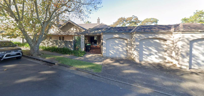
The dwelling
house on the site has been severely damaged in a fire on 3 September 2022. The dwelling house is listed as a local heritage item being a federation dwelling house under
Schedule 5 of Lane Cove Local Environmental Plan 2009.
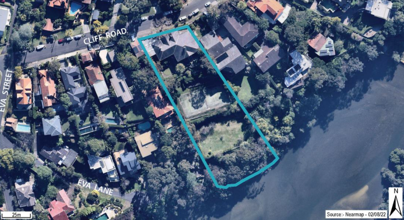
Figure
1 – The site.
The site
incorporates two lots and slopes steeply down from Cliff Road to the Gore Creek
foreshore. The site is separated by terraced area with the highest top terrace
being occupied by the primary fire-damaged dwelling and triple garage structure
(known as the western addition). The later western addition has not been as
severely damaged by the fire as the main heritage house. The garden area at the
rear of the dwelling house is located on the terraced area below. The third
terrace is occupied by a tennis court with an orchard area on the terrace area
below that terraced area. The southern-most terrace area is the largely
unaltered foreshore area with a stone boat shed and pontoon situated on the
water’s edge.
The main
dwelling house occupies both lots and the existing heritage dwelling does not
have a large setback from the street. The building is located behind a stone
rubble wall which conceals much of the dwelling house’s façade. As detailed in the structural advice letter prepared by Plantir and
the Heritage Impact Statement prepared by DFP Planning, the roof and roof
framing have been destroyed. Timber floors, joists and bearers have been
destroyed as well as most of the internal and external doors and window
joinery. The statement notes that the fire damage has revealed that internal
alterations were made to the house at some later time, including widened
openings supported by steel beams.
The bays on the south side of the house also appear to be later
alterations. The stonework is set in wide cement mortar joints and the openings
are supported on steel beams, uncharacteristic of early twentieth-century
construction. The figures below detail the condition of the site pre and post
fire.
Figure
2 – Dwelling from the Cliff Road frontage,
pre-fire.
Figure
3 – Dwelling and rear yard, pre-fire.
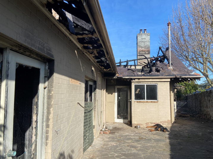
Figure
4 – View of the front house looking west
showing burnt-out roof, eaves and loss of slates.
Figure
5 – View of opening to terrace into the
house. Floors, joists and bearers have been destroyed, no roof or ceiling, and
architraves and door jambs are missing.
Figure
6 – View east across the south-eastern room.
There is no roof, ceiling or floor and architraves and door jambs have been
burnt. The fireplace surround is badly charred.
Figure
7 – External opening showing the original
arch and steel beam inserted to widen the doors. Cracked and missing wall
plaster can be seen on the rear wall.
Figure
8 – View to the north-west across the paved
terrace towards the later addition showing the bay window which is a later
addition. With a widened opening supported by a steel beam, the stonework has
wide cement mortar joints instead of the traditional fine lime mortar joints.
Figure
9 – View from the rear garden of the
sandstone stairs and flanking walls looking north dating from the original
construction phase.
Figure
10 – Rock shelf adjacent to the sandstone
stairs and flat lawn area on the lower terrace.
The subject site is located within the suburb of Northwood in
the Lane Cove Local Government Area and is surrounded by detached dwelling
houses. It is noted that the same owner owns the adjoining property to the
northeast at No. 60 Cliff Road. Cliff Road comprises a mixture of single and
multi-storey residential dwellings that are largely federation in style. The
dwelling houses generally have a deep setback from Cliff Road with a front
garden area and garages located within this setback. Access driveways punctuate
the streetscape at regular intervals.
PROPOSAL
The proposal
is for:
· the
demolition of the burnt-out remnants of the dwelling house and the later addition
to the west; and
· clearing
the part of the site that contains the burnt-out remnants of debris and
remediating the site of potentially hazardous materials (lead, asbestos) in
accordance with the Remediation Action Plan (RAP).
According to
the applicant, due to the September 2022 fire the heritage significance of the
dwelling house has been reduced to a low level. According to the applicant, the
low level of significance, together with the dangerous potential for
contaminants leaching into the site and surrounding environment would mean that
retention or reconstruction of the dwelling house would not be warranted. The
fire has also resulted in contaminants from the dwelling (asbestos and lead)
would lead into the site with potential for this to spread into the surrounding
environment. The subject Development Application intends to demolish the
burnt-out remnants and later additions and remediate the site.
Undamaged
site features are to be retained and these would comprise the paved terrace,
stone balustrades, steps and retaining walls at the rear of the existing
heritage dwelling based on the recommendations of the Heritage Impact Statement
(HIS).
Figure
11 – House and addition (in red and yellow
respectively) to be demolished and rear Terrace (in green) to be retained.
No works are
currently proposed between the terrace and the mean high-water mark.
The
justification provided as to why a replica is not being proposed is due to the
submitted Heritage Impacts Statement (HIS) stating that the question is whether there is sufficient remaining fabric and detail in which to
base reconstruction of the house. To answer this question, the
applicant’s heritage consultant advised that it would be necessary to
refer to the International
Council on Monuments and Sites (ICOMOS) Australia Burra
Charter to determine whether reconstruction of the dwelling house is a viable
option.
Article 20.1
states:
Reconstruction
is appropriate only where a place is incomplete through damage or alteration,
and only where there is sufficient evidence to reproduce an earlier state of
the fabric. In rare cases, reconstruction may also be appropriate as part of a
use or practice that retains the cultural significant of the place.
Article 20.2
states:
Reconstruction
should be identifiable on close inspection or through additional
interpretation.
The definition
of reconstruction is:
Reconstruction
means returning a place to a known earlier state and is distinguished from
restoration by the introduction of new material into the fabric.
According to the applicant’s heritage
consultant, insufficient original fabric has survived
on which to base a meaningful reconstruction. Any attempt to reproduce the
original building would create an inauthentic pastiche. The extent of works
required would be well beyond the meaning of reconstruction in the ICOMOS
Australia Burra Charter.
3. SECTION
4.15 ASSESSMENT
The following assessment is
provided against the relevant provisions of Section 4.15 of the NSW
Environmental Planning and Assessment Act, 1979:
|
3.1 Any
environmental planning instrument:
|
3.1.1 State Environmental Planning
Policy (SEPP) (Resilience and Hazards) 2021
The subject
site is mapped wholly as a Coastal Environment Area and Coastal Use Area and
part Coastal Wetland within Chapter 2 Coastal Management of the SEPP. The site
is already developed for low-density residential purposes. The subject
Development Application does not propose any intensification of this use. It is
proposed to demolish the burnt-out remains of the dwelling house and to
remediate the site from the contaminants that are leaking into the site due to
the fire. This in principle would assist in protecting the coastal zone.
As a result
of the fire and according to the applicant’s Remediation Action Plan
(RAP), there are contaminants leaking into the site. This would propose the
remediation of the site in accordance with the relevant standards and with
Chapter 4 Remediation of Land of the SEPP. There are no further matters raised
in a SEPP that would require consideration.
3.1.2 State Environmental Planning
Policy (SEPP) (Biodiversity and Conservation) 2021
The subject
site is within the Sydney Harbour Catchment and is mapped as being within the
Foreshores and Waterways Area within Chapter 6 Water Catchments of the SEPP.
The subject Development Application is consistent with the principles listed
under Clause 6.28.
3.1.3 Lane Cove Local Environmental
Plan (LCLEP) 2009
3.1.3.1 Permissibility
The proposed
demolition is permissible under Clause 2.7 of LCLEP 2009 which reads as:
2.7 Demolition requires development
consent
The demolition of a building or work may be carried out
only with development consent.
Note—
If the demolition of a building or work is identified in an
applicable environmental planning instrument, such as this Plan or State Environmental
Planning Policy (Exempt and Complying Development Codes) 2008, as exempt development, the Act enables it to be carried
out without development consent.
Further,
Clause 5.10(2)(a) states that:
(2) Requirement for consent Development
consent is required for any of the following—
(a) demolishing or moving any of
the following or altering the exterior of any of the following (including, in
the case of a building, making changes to its detail, fabric, finish or
appearance)—
(i) a heritage item,
(ii) an Aboriginal object,
(iii) a building, work, relic or
tree within a heritage conservation area,
The subject
Development Application is seeking development consent for the demolition of
the fire damaged heritage dwelling house on the site.
3.1.3.2 Heritage Conservation
The subject
site is listed as a heritage item within Schedule 5 of LCLEP 2009 and is
also entered in The NSW Heritage Inventory Database. The property was formerly
known as “Tallawalla”. The Statement of Significance of the site
reads as:
“Tallawalla”
is historically significant as one of the earliest dwellings built on the
Northwood Estate auctioned in 1904. The dwelling has been sympathetically
altered to include garages and the addition of a stone wall to Cliff Road. It
has landmark qualities and is aesthetically significant, adding to the
streetscape quality of Cliff Road.
The proposal is also subject to
Clause 5.10(5) of LCLEP 2009 due to the land being listed as a heritage item.
Clause 5.10(4) and (5) states the following:
(4) Effect of proposed development on
heritage significance The consent authority must, before granting consent
under this clause in respect of a heritage item or heritage conservation area,
consider the effect of the proposed development on the heritage significance of
the item or area concerned. This subclause applies regardless of whether a
heritage management document is prepared under subclause (5) or a heritage
conservation management plan is submitted under subclause (6).
(5) Heritage assessment The consent
authority may, before granting consent to any development—
(a) on land on which a heritage item is located,
or
(b) on land that is within a heritage
conservation area, or
(c) on land that is within the vicinity of land referred to in
paragraph (a) or (b), require a heritage management document to be prepared
that assesses the extent to which the carrying out of the proposed development
would affect the heritage significance of the heritage item or heritage
conservation area concerned.
It is noted that the applicant
had submitted a Heritage Impact Statement (HIS) however they failed to submit a
Heritage Conservation Management Plan (HCMP) with the subject Development
Application. The HIS indicates the main components of the site:
· The burnt-out original house is shown in red outline as shown in
Figure 11 above. According to the statement, in its undamaged state, it would
have been assessed as having high significance warranting retention and
conservation. The current state of the remnants reduces the significance to low
category due to some ability to interpret the plan layout from the
walls. A low level of significance together with the dangerous condition of the
ruins means that retention and reconstruction are not warranted.
· The later additions to the west of the house are outlined
in yellow.
This part of the house is partly intact, but it is not of significance having a
neutral effect on the value of the house as it was before its destruction.
· The terrace and low stone walls (outlined in green) appear to have
been integral to the design concept of the house and are evaluated as having a
high level of significance, worthy of retention and conservation.
· The landscaped area to the south (outlined in blue) comprising lawn,
rock shelves and stone walls contributes to the scenic values of the foreshore
slopes as seen from Gore Creek and Greenwich. Further research is necessary to
evaluate the significance of the trees, plants and structures in the area. The
area made an important contribution to the setting of the house and in this
role is assessed as being of moderate significance. Regardless of the loss of
the house, it is of scenic value.
The origins of the tennis court are not known. The tennis
court appears in a 1943 aerial photograph. Further research may reveal when the
tennis court was constructed and what level of significance should be
attributed to it.
The HIS had found that assessment of the effect of
the proposed demolition of the remnants of the house needs to be made in a
two-step process. The first step is to consider the effect of the fire damage
on the significance of the house. The fire has removed almost all the
significant fabric that would have enabled an understanding and appreciation of
the heritage values of the house. Therefore, the effect on the significance of
the house is severe. Given the extent of damage, the loss of heritage values is
irreversible and beyond meaningful reconstruction.
The second
step is to assess whether the proposed demolition would prevent a meaningful
interpretation of the heritage values of the house. There is insufficient
fabric remaining to achieve this objective. Furthermore, the remaining
structure is in a dangerous condition. The additional impact of demolishing the
remnant fabric of the house would be minor.
The HIS
concluded that the e extent of fire damage is such that
meaningful reconstruction of the house is not possible. The extent of new
fabric would result in an inauthentic, and probably inaccurate, replica. The
dangerous condition of the remnant walls and debris warrant demolition and
removal as a priority safety precautionary action.
Comment:
The applicant has not
adequately demonstrated that the proposal as submitted would ensure that the
relevant heritage values of the site would be retained or protected should
approval be granted to the subject application. This is primarily due to the
inadequate or unclear nature of the information being proposed. Demolition of a
heritage item, even a burnt-out item should always be the last and final
option.
There is no clear roadmap being provided for in
how the site would evolve from this point on with regard to heritage and
the future development potential of the site moving forward. The applicant has
completely dismissed the potential option for a genuine rebuild or replica of
the existing dwelling. Whilst it may not be the original house, any new
dwelling should be designed in a manner that pays respect to the sites and
dwellings federation past. No such undertaking or concept plans have been
offered or provided by the applicant in this case. Demolition of this nature is
considered inappropriate on this basis without further detailed investigation
occurring.
There has been no comprehensive investigation,
research, archival recording, and measured drawings completed to even consider
approving this application to enable establishment of any site-specific
controls. The western addition had been completely dismissed and should be
retained until a full assessment is completed to ensure identified elements of
heritage value are protected or recorded. It is
possible that documentary evidence is available, together with surviving
remnant structure to feasibly achieve an authentic reconstruction. The potential
for a meaningful reconstruction of the dwelling house should be researched to
establish whether there is sufficient evidence available to reproduce the
earlier (undemolished) state.
There have been
numerous instances where developers through their heritage architects have
successfully attempted to provide for a genuine replica when rebuilding a
demolished heritage item.
Typically the
rebuilding of a demolished heritage item would require:
· The preparation of plans that would facilitate an accurate
reconstruction of the building; and
· Any approval would then involve the reconstruction process to be supervised by a qualified heritage specialist.
Further, the extent of remediation works proposed
do not seem to match the heritage value of the site where the RAP suggests that
the vegetated area and the mortar between the sandstone walls may need to be
removed to remove any contaminants present on the site. In addition, the RAP
also suggests that the whole affected would require the removal of soil. This
is not supported and seems excessive which indicates that the applicant has no
real intention of ultimately protecting any heritage values currently present
on this site. No mention of this is made within the Statement of Environmental
Effects (SEE) and the Heritage Impact Statement (HIS).
The absence of site-specific controls would fail
to protect and retain important historic and natural
features on site. Site specific controls should be established prior to any
applications being determined. Based on this lack of clarity involved or offered by the applicant at
this stage, it would not be in the public interest to approve this application
in this instance. Accordingly, the proposal is not
considered to satisfy Clause 5.10 and its objectives including relevant aims
and zone objectives of LCLEP 2009 such as:
5.10 Heritage conservation
(1) Objectives The
objectives of this clause are as follows—
(a) to conserve the
environmental heritage of Lane Cove,
(b) to conserve the heritage
significance of heritage items and heritage conservation areas, including
associated fabric, settings and views,
1.2 Aims of Plan
(2) The particular aims
of this Plan are as follows—
(aa) to protect and promote the
use and development of land for arts and cultural activity, including music and
other performance arts,
(a) to establish, as the first
land use priority, Lane Cove’s sustainability in environmental, social
and economic terms, based on ecologically sustainable development,
inter-generational equity, the application of the precautionary principle and
the relationship of each property in Lane Cove with its locality,
(b) to preserve and, where
appropriate, improve the existing character, amenity and environmental quality
of the land to which this Plan applies in accordance with the indicated
expectations of the community,
(c) in
relation to residential development, to provide a housing mix and density
that—
(ii) is compatible with the existing
environmental character of the locality, and
(iii) has a sympathetic and harmonious relationship
with adjoining development,
(f) in
relation to conservation—
(iii) to control all new buildings to ensure
their compatibility with surrounding existing built form and natural
environmental character, and
(iv) to conserve heritage items,
Zone
R2 Low Density Residential
• To retain, and where
appropriate improve, the existing residential amenity of a detached single
family dwelling area.
• To ensure that
landscaping is maintained and enhanced as a major element in the residential
environment.
3.1.3.3 Earthworks
Clause 6.1A of the LEP reads as:
6.1A Earthworks
(1) The objectives of this clause are as
follows—
(a) to ensure that earthworks
for which development consent is required will not have a detrimental impact on
environmental functions and processes, neighbouring uses, cultural or heritage
items or features of the surrounding land,
(b) to allow earthworks of a
minor nature without requiring separate development consent.
(2) Development consent is required for earthworks
unless—
(a) the work is exempt
development under this Plan or another applicable environmental planning
instrument, or
(b) the work is ancillary to
other development for which development consent has been given.
(3) Before granting development consent for
earthworks, the consent authority must consider the following
matters—
(a) the likely disruption of, or
any detrimental effect on, existing drainage patterns and soil stability in the
locality,
(b) the effect of the proposed
development on the likely future use or redevelopment of the land,
(c) the quality of the fill or
the soil to be excavated, or both,
(d) the effect of the proposed
development on the existing and likely amenity of adjoining properties,
(e) the source of any fill
material and the destination of any excavated material,
(f) the likelihood of disturbing
relics,
(g) the proximity to and
potential for adverse impacts on any watercourse, drinking water catchment or
environmentally sensitive area.
Although not
mentioned within the SEE and the HIS, the RAP requires earthworks to cover
approximately an area of 1,100sqm involving excavation to a depth of 0.1m below
natural ground level (see Figure 11 below).
Figure
12 – Areas hatched in red proposing the
extent of earthworks
This would
suggest that everything in the areas hatched in red in the figure would have to
be removed as the RAP based on the recommendations contained in the report
which includes removal of mortar between the terraced sandstone wall structure.
It is considered that the proposed excavation would have adverse heritage
impacts as discussed further within this report in more detail, where it is
considered that the extent of excavation is not supported as it would be
inconsistent with the heritage character of the site.
It is intended that this would
lead to an outcome where the remaining heritage values of the site would be
effectively removed to enable full remediation and the ultimate redevelopment
of a new dwelling which would not have to address any heritage elements that
otherwise would have remained present on the site.
|
3.2
Any proposed instrument (Draft LEP, Planning Proposal)
|
N/A
|
3.3
Any development control plan
|
3.3.1 Lane Cove Development Control Plan
LCDCP – Part B.9 Heritage
As detailed
above, the proposal is unsatisfactory as it would have
unacceptable impacts on the status of the existing heritage item. Inadequate
documentation had been prepared with the subject application such as submission
of a detailed photographic record and heritage conservation plan as required
under Part B.9.1(d) – Heritage Items and the Conservation Area. This lack
of detail is not sufficient to permit the approval of any demolition of a heritage
dwelling house. Based on the above discussions contained within this report, it
is considered that the following DCP general objectives would not be met as
follows:
•
Support the locality’s sustainability in environmental, social and
economic terms.
• Conserve,
protect and enhance the environmental and built heritage of Lane Cove.
• Minimise
any impacts of the redevelopment of uses not conforming to the zone they are
in, by having regard to the scale and character of the surrounding
neighbourhood.
• Balance
individual and community interests to preserve and, where appropriate, improve
the existing character and amenity of the municipality.
|
3.4 The
likely impacts of that development, including environmental impacts on both
the natural and built environments, and social and economic impacts in the
locality
|
The impacts on both the natural
and built environments of the locality have been considered and addressed in
the report and are unsatisfactory.
|
3.5 The
suitability of the site for the development
|
The proposed
development does not respond appropriately to the site constraints and
therefore the site is not suitable for the development.
|
3.6 Any
submissions made in accordance with this Act or the regulations
|
The proposed development was
notified in accordance with Council policy and three submissions including a
submission from the Lane Cove Historical Society were received. The other
submissions came from Nos. 35 and 56B Cliff Road. The submissions main concerns
are summarised and addressed within the table below as follows:
|
Summary of
Submissions
|
|
Concern
|
Comment
|
|
The residents
are hoping that the building will be restored to the
original state or rebuild a replica. Otherwise, once demolition
would occur, the owner would redevelop the site in an uncontrolled manner
with respect to relevant heritage considerations.
|
In this
instance, this is a reasonable request based on the unique circumstances of
this matter. The proposed retention of the rear elements would assist in the
rebuild of a federation style dwelling reminiscent of and pays homage to its
predecessor.
|
|
Any
redevelopment purposes ought to ensure that is it built within the envelop of the original home so that the water views
for many homes on Cliff Road including our home are not affected as these
homes were purchased based on these views and which were not expected to
change due to the heritage nature of this property.
|
Any new
designs would need to address the relevant heritage values present on the
site and relevant view sharing principles that are applicable. Whether the
new dwelling would be an exact replica is not known as this stage and this
matter would need to be ultimately resolved in a satisfactory manner moving
forward.
|
|
The subject
application ought not to be approved until the legal matters associated with
this site is ultimately resolved.
|
The alleged
criminal case is a separate matter which would be resolved in time, however
determination of this application should not be predicated on the result of
this.
|
|
The assessment
should be undertaken by more than one heritage expert as there would be many views about the repairing restoring, reconstructing, process
of this damaged heritage building.
|
Agreed, the
subject application has been assessed by various heritage consultants which
has been determined that the proposal as submitted should not be supported in
this instance.
|
|
As the
surrounds of the building do not appear to be damaged, would these areas,
would remain under a heritage status.
|
As a minimum, undamaged site
features are to be retained and these would comprise the paved terrace, stone
balustrades, steps and retaining walls at the rear of the existing heritage
dwelling although further work needs to be completed to ensure more heritage
values are protected moving forward.
|
|
The spread of
contaminants in the air and soil during the demolition process would occur,
which can harm the health of residents.
|
Any removal of
contaminants would be conducted in a manner that would be in accordance with
relevant health or safety regulations and guidelines.
|
|
Concerns
from the Lane Cove Historical Society
For the
abovementioned reasons and until the site and building’s history is
fully investigated and recorded, and its significance reassessed, only the
minimum demolition (and remediation) required to secure the safety of the
site should be approved or occur under this DA.
|
The extent of initial demolition work should be limited to a
minimum extent required to secure the safety of the site. Site specific controls can only be determined by Council after a
comprehensive investigation, research, archival recording, and measured
drawings are completed by the applicant.
|
|
The west part
of the building as well as the foundations and footprint should be kept or at
least recorded so that they can inform the location and form of future
development and to maximize the opportunity for retention of historic site
elements and natural features.
|
The west part
of the building which has incurred less damage than the remainder of the
building is a later extension and is unlikely to have the high level of
significance of the original 1915 section. However, it should be retained
until a full assessment is completed and ensure identified elements of
heritage value are protected or recorded.
|
|
The potential
for a meaningful reconstruction of the place should be researched to establish
whether there is sufficient evidence available to reproduce the earlier (undemolished) state. This evidence should include surviving
physical fabric but also evidence from documentary sources, such as photos,
drawings, previous approvals etc.
|
It is possible
that documentary evidence is available, together with surviving remnant
structure to feasibly achieve an authentic reconstruction as after demolition
of the remaining unstable structure the site would be essentially razed to
ground level. Any attempt at conservation of the ruins would result in almost
total reconstruction, resulting in a new replica of the 1915 heritage
building whilst not ideal would be the correct outcome in this instance.
|
|
The Inventory
Form and the Statement of Significance, that underpin the LEP heritage
listing should be reviewed immediately to identify and reference significant
site features and landscape components in the Inventory Form. All the
remaining physical evidence should be recorded together with documentary
evidence, including historical research, to provide a comprehensive record of
the site’s development and to inform any future development.
|
The inventory
has not been updated by the applicant’s heritage consultant. Approval
of a DA based on an inventory for a heritage building which no longer exists,
would compromise any desired outcome which protects the heritage values of
the site, and leaves open unintended consequences and the potential for legal
issues.
|
|
It is
recommended that site specific controls for this site be developed to ensure
that important historic and natural features would be retained, prior to this
application and any further DAs being lodged to redevelop the site.
The site
should continue to be managed as a heritage item, as is its current statutory
status throughout the demolition, rectification, remediation, and
redevelopment process. Significant or historically aesthetically important
built or landscape elements, and natural features should be carefully
identified in consultation with the applicants Heritage Consultant and
Council’s Heritage Advisor to ensure that they are protected from any
further damage during the demolition and remediation process.
|
A
comprehensive set of site-specific controls should be developed, following a
comprehensive investigation by the applicant to ensure protection of
remaining elements. Extensive landscape features including sandstone
structures, retaining walls, steps, the east terraced area, and the stone
wall to the street boundary have already been identified.
The extent of
potential significant elements can only be determined after detailed
investigation and research. Council is aware of the sensitivity of controls
for future development of the site when the current DA is for demolition only.
The first stage of redevelopment and the site would continue with protection
of the heritage listing. The implications for other heritage items are
acknowledged, however the circumstances in this case are unique and should
not create a precedent.
|
Comment: In general, the concerns raised by the historical society are
supported, and the extent that these can be implemented. This would be
dependent on further site investigation and research outlined above. Further
consultation with the society and relevant heritage consultants during this
process would be welcomed. It is recommended that the subject application be
refused until a new assessment of significance is carried out and the heritage
listing be updated immediately to reflect the current situation and identify
significant elements to be retained. Finally, the recommendation by the
residents that a replica be rebuilt is supported in this case, due to its
unique circumstances involved.
|
RECOMMENDATION
That pursuant
to Section 4.16(1)(b) of the Environmental Planning and Assessment Act, 1979
the Lane Cove Local Planning Panel at its meeting of 21 February 2024 refuse
the subject Development Application DA100/2023 for the proposed part demolition of an existing heritage dwelling house including
site remediation on land
known as No. 62 Cliff Road, Northwood for the following reason:
1. LEP zoning objectives, aims of
Plan:
The proposed development would be inappropriate on the subject
heritage site and is inconsistent with the following aims and R2 Low Density
Residential of LCLEP 2009 as follows:
Particulars:
1.2 Aims
of Plan
(2) The
particular aims of this Plan are as follows—
(aa) to protect and promote
the use and development of land for arts and cultural activity, including
music and other performance arts, to establish, as the first land use
priority, Lane Cove’s sustainability in environmental, social and
economic terms, based on ecologically sustainable development,
inter-generational equity, the application of the precautionary principle and
the relationship of each property in Lane Cove with its locality,
(b) to preserve
and, where appropriate, improve the existing character, amenity and
environmental quality of the land to which this Plan applies in accordance
with the indicated expectations of the community,
(c) in relation to residential development, to
provide a housing mix and density that—
(ii) is compatible
with the existing environmental character of the locality, and
(iii) has a
sympathetic and harmonious relationship with adjoining development,
(f) in relation to conservation—
(iii) to control all new buildings to ensure their compatibility
with surrounding existing built form and natural environmental
character, and
(iv) to conserve heritage
items,
Zone R2 Low Density
Residential
· To retain, and where appropriate
improve, the existing residential amenity of a detached single family
dwelling area.
· To ensure that landscaping is
maintained and enhanced as a major element in the residential environment.
2. LEP Heritage provisions of the
Plan:
The proposed development would be inappropriate on the subject
heritage site and is inconsistent with Clause 5.10 – Heritage
conservation of LCLEP 2009 and does not satisfy the relevant
objectives as follows:
Particulars:
Objectives The objectives of this clause are as follows—
(a) to conserve the
environmental heritage of Lane Cove,
(b) to conserve the heritage significance of
heritage items and heritage conservation areas, including associated fabric,
settings and views.
3. LEP Earthwork provisions of the
Plan:
The proposed development cannot be granted due to the inability to
fully satisfy the earthworks provisions of the Lane Cove LEP 2009:
Particulars:
Clause 6.1A – Earthworks of LCLEP 2009. Including:
· (3) Before granting
development consent for earthworks, the consent authority must consider the
following matters—
(f) the likelihood
of disturbing relics,
The extent of earthworks proposed is not supported as it would be
inconsistent with the
heritage values currently present on the subject site and does account for
the disturbance of heritage relics on the site.
4. DCP Heritage provisions:
The development does not comply with the following requirements of
Lane Cove Development Control Plan (LCDCP) 2009 Part B –
General Control in respect of:
Particulars:
· Part B General Objectives for the DCP
Part 1.1 General Objectives –
- Support the locality’s sustainability in
environmental, social and economic terms.
- Conserve, protect and enhance the environmental
and built heritage of Lane Cove.
- Contribute to effective management of biodiversity.
- Minimise any impacts of the redevelopment
of uses not conforming to the zone they are in, by having regard to the scale
and character of the surrounding neighbourhood.
- Balance individual and community interests to
preserve and, where appropriate, improve the existing character and amenity
of the municipality
· Part 9.1(d) Heritage Items
and the Conservation Area.
(d) Photographic records of all heritage listed items to be
demolished or to be changed is to be undertaken prior to release of the
construction certificate.
(f) Development involving a heritage item may be required to be in
accordance with an up - to - date Conservation Management Plan and/or
Specific Element Conservation Policy (SECP).
(i) The
proposed development would have an unreasonable impact upon the existing
heritage values currently present on the subject heritage site. The impacts
on the environmental, built, and social environments on the site and locality
are unsatisfactory. The cumulative heritage impact of
the proposal is unreasonable.
(ii) The subject Development Application should be refused
because the proposal would not be suitable for the subject heritage site
having regard to the unnecessary heritage impacts that the proposal would
have.
(iii) The subject Development Application should be refused
primarily for the reasons provided above, and approval of the application
would be contrary to the public interest. Approval
of the proposal would be contrary to the public interest as it would provide
for an inappropriate form of development of the subject heritage site.
5. Insufficient
Information:
Insufficient information has been submitted in support of the
application in accordance with Clause 36 of the Environmental Planning
& Assessment Regulations (EPAR) 2021 with respect to:
Particulars:
· Inadequate documentation had been prepared with the subject
application such as submission of a detailed photographic record and heritage
conservation plan as required under Part B.9.1(d) – Heritage Items and
the Conservation Area.
· The documentation does not include
any potential for alternatives to demolition such as a genuine rebuild or
replica of the existing dwelling.
· The applications fails to provide a
comprehensive investigation, research, archival recording, and measured
drawings to enable establishment of any site-specific controls.
6. Public Interest:
The proposal does not with the relevant evaluation provisions of
clause 4.15 of the Environmental Planning and Assessment Act 1979 and is not
in the public interest.
The subject Development Application should be refused primarily
for the reasons provided above, and approval of the application would be
contrary to the public interest. Approval of the proposal would depart from
the existing local Northwood character which should respond to and be
informed by a more sensitive approach to the heritage status of the site.
Particulars:
4.15 Evaluation (1) Matters
for consideration - general
In determining a development
application, a consent authority is to take into consideration such of the
following matters as are of relevance to the development the subject of the
development application—
(a) the provisions of—
(i) any environmental planning instrument, and
(b) the
likely impacts of that development, including environmental
impacts on both the natural and built environments, and social and economic
impacts in the locality,
(c) the suitability of the
site for the development,
(e) the public interest.
|
ATTACHMENTS:
There are no supporting documents for this report.
Lane Cove Local Planning Panel Meeting 21
February 2024
180 River Road, Lane
Cove
Subject: 180
River Road, Lane Cove
Record No: DA22/147-01 - 7256/24
Division: Planning
and Sustainability Division
Author(s): Robert
Montgomery
|
Property:
|
180 River Road Lane Cove (comprises
various lots)
|
|
DA No:
|
DA 147/2022
|
|
Date Lodged:
|
1 December 2023
|
|
Cost of Work:
|
$61,912,148.00
|
|
Owner:
|
Lane Cove Council
|
|
Applicant:
|
Lane Cove Council
|
|
Description of the proposal to appear on
determination
|
Modification
pursuant to s4.55(1A) of Development Consent
DA147/2022 and approved plans to reflect minor design changes that have
occurred as the project progresses. These changes include internal rearrangement,
changes to stairs and landscaping.
|
|
Zone
|
RE1 Public Recreation
|
|
Is the proposal permissible within the
zone
|
Yes
|
|
Is the property a heritage item
|
No
|
|
Is the property within a conservation
area
|
No
|
|
Does the property adjoin bushland
|
No
|
|
BCA Classification
|
Class 5, 6, 7a, 9b
|
|
Stop the Clock used
|
No
|
|
Notification
|
Neighbours: Notified from 1 December 2023 to 19 January 2024
Ward Councillors
Progress Association
Other
|
SITE
|
Property
|
Various lots to be consolidated as a consequence
of DA. Known as 180- River Road Lane Cove
|
|
Area
|
2.006ha
|
|
Site location
|
180 River Road Lane Cove
|
|
Existing improvements
|
Golf Club, pro shop, outdoor tennis
courts, car parking and outbuildings
|
|
Shape
|
Irregular
|
|
Dimensions
|
Width
Depth
|
|
Adjoining properties
|
East – Lane Cove Golf
Course
West – 8 dwellings
Nort – Lane Cove Golf
Course
South – Lane Cove Golf Course
|
SITE APPLICATION HISTORY
|
DA 147/2022
|
Construction
of a sports and recreation facility – Approved by Sydney North Planning
Panel on 3 May 2023.
|
|
|
|
PROPOSAL
|
The proposal is for a number of minor
modifications to the consent and approved plans for construction of a sports and recreation
facility, which was approved by Sydney North Planning Panel on 3 May 2023.
The modification comprises numerous changes brought about by the need for BCA compliance,
operational requirements and the ongoing design process. The changes are
detailed in Table 1 contained within this report. In summary, the changes
relate to stair location, additional skylights, relocation of golf pro shop,
alterations to driveway and pedestrian pathway, internal reconfiguration,
additional shade structure, minor reduction in roof overhang, amendments to
landscape planting schedules and changes to entry design.
The application is made pursuant to Section
4.55(1A) of the Environmental Planning and Assessment Act, 1979.
|
PROPOSAL DATA/POLICY
COMPLIANCE
Lane Cove Local Environmental Plan
2009
Zoning: RE1
Public Recreation Site
Area: 2.006ha
|
LEP table
|
|
|
Development Standard
|
Proposal
|
Complies
|
|
Floor Space Ratio
(max)
|
No maximum specified
for the site.
|
|
N/A
|
|
Height of Buildings
(max)
|
No maximum specified
for the site.
|
|
N/A
|
Comprehensive Development Control
Plan
The development was assessed against the relevant
provisions of the Lane Cove Development Control Plan and was found to be compliant.
The proposed modification does not bring about any non-compliance.
REFERRALS
(a)
The application was
referred to Council’s Director Open Space and Infrastructure, who raised
no objection to this modification subject to the submission of detailed
construction methodology for assessment prior to the issue of a Construction
Certificate. Condition C.10 of the original consent requires this to
occur.
REASON FOR REFERRAL
The modification application is referred to the Lane
Cove Local Planning Panel as Lane Cove Council is the owner of the land.
EXECUTIVE SUMMARY
This assessment report is prepared by Robert
Montgomery, an independent town planner engaged by the Council to assess the
application.
The Section 4.55(1A) application
seeks to modify Development Consent DA147/2022 by proposing a number of changes
relating to stair location, additional skylights, relocation of golf pro shop,
alterations to driveway and pedestrian pathway, internal reconfiguration,
additional shade structure, minor reduction in roof overhang, amendments to
landscape planting schedules and changes to the entry design.
The modification comprises a number of minor changes,
which are required in part to achieve BCA compliance, future operational
requirements and the ongoing design process.
Approved by the
Sydney North Planning Panel on 5 May 2023, the development is described as:
“Demolition of existing
structures and construction of a (part two and part three storey/mezzanine)
sports and recreation facility.”
The approved development comprises four new outdoor
multi-purpose courts, indoor sports hall, multipurpose shared spaces, bistro,
outdoor dining terrace, lounge space, meeting rooms and golf pro shop.
The Sydney North Planning Panel previously delegated
all functions relating to determination of applications to modify consent to
Council’s General Manager. However, as the Council is the owner of
the land, the application is referred to the Lane Cove Local Planning Panel for
determination.
In accordance with the Lane
Cove Community Participation Plan, the application was notified from 1 December
2023 to 19 January 2024. Seven submissions were received.
The modification application has been assessed under
the provisions of Sections 4.15 and 4.55 of the Environmental Planning and
Assessment Act, 1979, and is recommended for approval.
SITE
The site, known
as the Lane Cove Golf Course and Lane Cove Country Club, is located at 180
River Road, Lane Cove. The site is approximately 3km south of Chatswood CBD and
4km north-west of North Sydney CBD.
River Road is classified as a
regional road, which provides a connection between St Leonards in the east and
Lane Cove in the West. Figure 1 below shows the location in the context of
surrounding town centre’s and road network.
Figure 1: Location Source: NSW LPI SIX Maps
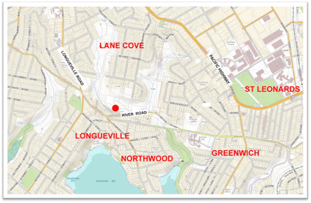
Figure 2: Satellite Image. Google Maps and Ethos Urban
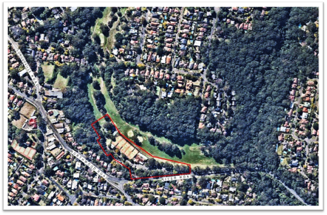
The
land currently provides local sporting facilities in the form of five (5)
floodlit synthetic tennis courts, Lane Cove Country Club building, various
outbuildings, a greenkeepers cottage and carparking. The land comprises a
number of lots which includes the adjoining golf course. It is proposed
to consolidate all lots and re-subdivide to create a lot of 2.006ha, which will
contain the proposed recreation centre.
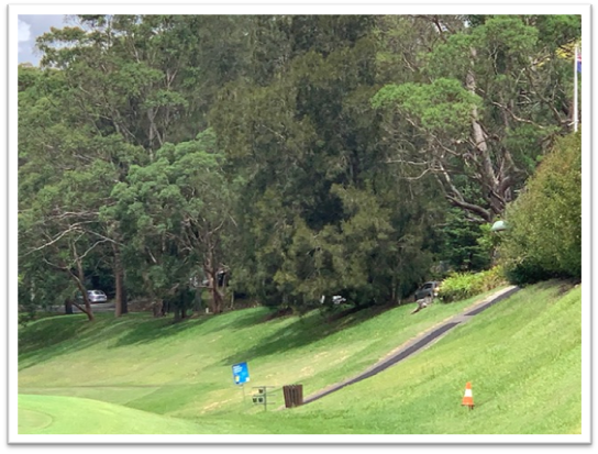
Figure 3: Golf Club Building with grassed bank down to golf course
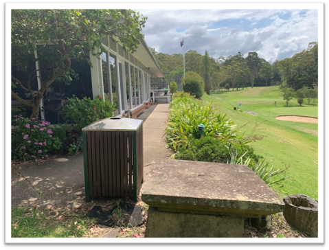
Figure 4: Tennis Courts
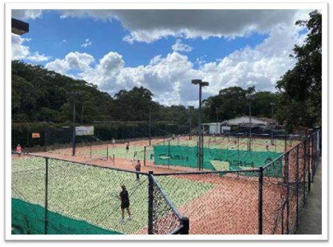
Figure 5: Car Park with Escarpment behind
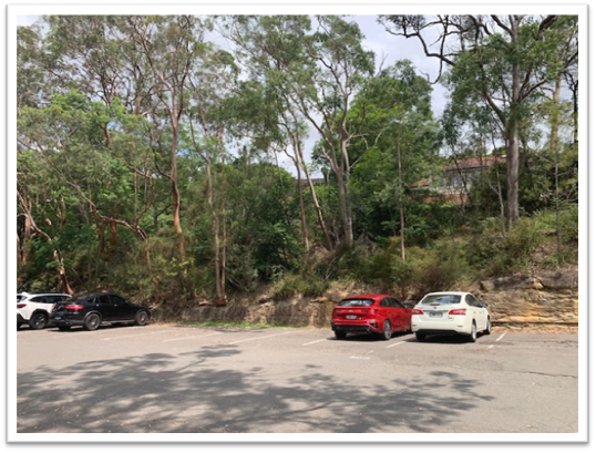
Figure 6: Car Parking near Golf Club
Building
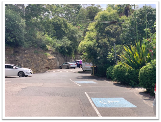
Figure 7: Maintenance Buildings
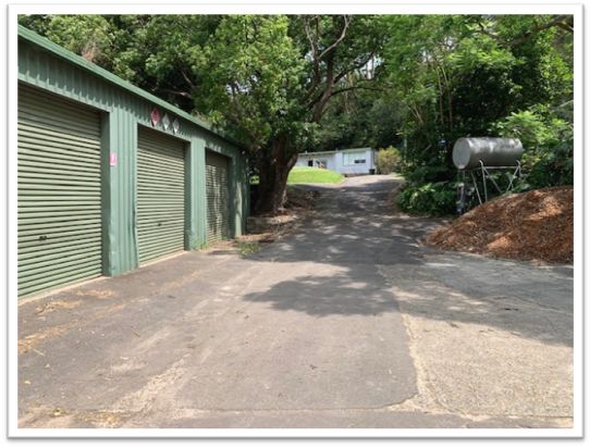
Figure 8: Grass Bank Transition between development site and golf
course
The site is surrounded by the Lane Cove golf course to the
north, east and south of the site. Eight dwellings, with frontage to
Northwood Road, adjoin the site to the west and seven dwellings, with frontage
to Fleming Street, are located on the southern side of River Road.
PREVIOUS APPROVALS/HISTORY
Approved by the Sydney North Planning
Panel on 5 May 2023, the development is described as:
“Demolition of existing
structures and construction of a (part two and part three storey/mezzanine)
sports and recreation facility.”
Since development consent was issued, the site has
been secured by construction fencing and ground works have commenced.
Attachment 5 is a copy of the development consent
issued on 9 May 2023.
PROPOSED MODIFICATION
The application seeks to amend
the following conditions:
· Condition A.1 – Approved plans and supporting documentation;
· Condition A.4 Tree preservation and approved
landscaping works; and
· Condition C.11 – Entry Design.
These conditions relate to the details of
the approved plans, the management of trees on site and the design of the
entrance. In summary, the changes relate to stair location, additional
skylights, relocation of golf pro shop, alterations to driveway and pedestrian
pathway, internal reconfiguration, additional shade structure, minor reduction
in roof overhang, amendments to landscape planting schedules and changes to
entry design.
Design Changes
The applicant states that the
modified plans are considered appropriate due to the following:
· Improvements to the functionality of the building and
rationalisation of the layout.
· Improved pedestrian access from River Road. This was also a
requirement of the consent conditions.
· Improved driveway access, drop off and loading area from River Road.
· Provision of increased light from additional skylights
· Improved functionality of landscaping within the building
· Improved shading
· Improved access within the building
· A kitchen and bistro area that will have an improved function due to
rearrangement.
· Improved storage areas. The increase in floor area for this area was
a part of an existing void next to the rock escarpment negating any impact on
neighbouring properties or visual impact.
· Improvements to window design for light and privacy and design.
· Additional viewing space from the internal balcony within the multi
purpose hall without impacting on the bulk or footprint of the building.
· The pro shop, buggy store and staff room are located conveniently
adjoining the practice and the proposed first tee area.
· The proposal to retain the internal driveway access from Stevenson
Street to the site for Council access to the golf course will merely maintain
the existing access with a more restrictive impact. This will be due to
the installation of a swing gate that will be installed at the high point of
the driveway blocking public access.
· There will be no impacts on traffic or parking as the intensity of use of the site will
not change.
Landscaping and Tree Removal
The applicant states that the
modified plans comprise the following:
· Add the first tee.
· Update the landscaping for the building,
accessways, entries and to accommodate the proposed building design changes.
The plans reflect the revised floor plans.
· Amend the bleacher seating and add a
shelter.
· Amend the planting schedules with a substantially
higher ratios of indigenous plants.
Two trees, T81- Angophora costata,
Sydney Red Gum, and no number-Eucalyptus pilularis, Blackbutt, which
grow along the edge of the rock escarpment, are to be removed. An arborist
report submitted with the application found that it is likely that as these
trees grow, cracks within the rock shelf will increase in size and the
integrity of the rock face may be compromised. The arborist report concluded
that the trees have a TreeAZ retention rating of Z8 (trees that are likely to
be removed within 10 years through responsible management of the tree
population).
Entry Design
Condition C11 requires a number of
treatments to enhance the entrance to the building. The applicant notes that
the façade of this elevation will be clad with colorbond and was
incorrectly described as concrete in the condition. The applicant also submits
that additional landscaping at the base of the eastern wall will not be
practical due to limited space, high usage and would be located under an
overhang to be provided for weather protection of the drop off zone.
Attachment 3 is a detailed schedule of the
changes proposed.
SECTION 4.55 ASSESSMENT
The application is made under section 4.55(1A) of the Environmental
Planning and Assessment Act, 1979. This section relates to
“modifications involving minimal environmental impact” and provides
that the consent authority may modify the consent if:
(a) it is satisfied that the
proposed modification is of minimal environmental impact, and
(b) it is satisfied that the
development to which the consent as modified relates is substantially the same
development as the development for which the consent was originally granted and
before that consent as originally granted was modified (if at all), and
(c) it has notified the
application in accordance with—
(i) the regulations, if the
regulations so require, or
(ii) a development control plan, if the
consent authority is a council that has made a development control plan that
requires the notification or advertising of applications for modification of a
development consent, and
(d) it
has considered any submissions made concerning the proposed modification within
any period prescribed by the regulations or provided by the development control
plan, as the case may be.
In relation to section 4.55(1A) (a), it is considered
that the changes proposed by the modification are of minimal environmental
impact only. There is no enlargement or expansion of the building
footprint or driveway area. The pedestrian walkway has been relocated to
minimise the impact on existing trees, as required by Condition C.10 of the
consent.
In relation to section 4.55(1A) (b), the Panel is
advised that the description, use and nature of the development is unchanged
and the proposal remains consistent with the approved development description. The
height of the building, building envelope, car parking remain consistent with
the approved development and no additional development is proposed.
Accordingly, the Panel can be satisfied that the
proposed modification is of minimal environmental impact and is substantially
the same development as the development for which the consent was originally
granted.
In relation to section 4.55(1A)(c), the application
was notified from 1 December 2023 to 19 January 2024 in accordance with the
Lane Cove Community Participation Plan. Seven submissions were received,
which are summarised in Table of this report.
Pursuant to Section 4.55(3) of the Act, the consent authority must also take into
consideration the reasons given by the consent authority for the grant of the
consent that is sought to be modified. The reasons for the decision are
contained within the:
1.
· Sydney North Planning Panel Determination and
Statement of Reasons dated 5 May 2023; and
· Assessment Report to SNPP dated 3 May 2023.
Copies of these documents are
Attachments 1 and 2.
Having reviewed and considered the reasons
for determination, it is concluded that the proposed modification is not in
conflict with any of those reasons.
SECTION 4.15(1) MATTERS FOR
CONSIDERATION
In determining an application for
modification of a consent under section 4.55(3), the consent authority must
take into consideration such of the matters referred to in section 4.15(1) as
are of relevance to the development the subject of the application.
The following section 4.15(1) matters have been
considered.
Environmental
Planning Instruments
The following Environmental
Planning Instruments apply to the land:
· State Environmental Planning Policy (Planning Systems) 2021
· State Environmental Planning Policy (Resilience and Hazards) 2021
· State Environmental Planning Policy (Transport and Infrastructure)
2021
· State Environmental Planning Policy (Biodiversity and Conservation)
2021
· Lane Cove Local Environmental Plan 2009
All of the above environmental planning
instruments (EPIs) were considered in the assessment of the original
development application. The minor nature of the modifications proposed
does not give rise for the need for a detailed examination of the EPIs.
Notwithstanding, a review and consideration
of the relevant provisions of the above Environmental Planning Instruments
confirms that the proposed modification creates no impacts beyond the original
development consent.
Draft Environmental Planning
Instruments
There are no draft instruments.
Development
Control Plans
Lane Cove Development Control
Plan 2010 (LCDCP) applies to the site. The development application
was assessed against the provisions of the LCDCP in the assessment report dated
3 May 2023.
Having reviewed the proposed
modification, it is concluded that the proposal satisfies the requirements of
the Lane Cove Development Control Plan.
Regulations
The Environmental Planning and Assessment
Regulation, 2021 (EP&A Reg) contains provisions relating to
modification applications. The following clauses apply:
Table 1: Summary of Relevant Clauses in the EP& A Reg, 2021
|
Clause
|
Summary
|
Comment
|
|
98
|
Sets out who can make an application
|
Complies
|
|
99
|
Form, particulars and lodgement
|
Complies
|
|
100
|
Content required
|
Complies
|
|
104
|
Consent authority may ask for additional information
|
A request for additional information was made on 23
January 2024. A satisfactory reply was received on 6 February 2024.
|
|
105
|
Requires notification of 4.55(1A) if required by
local community participation plan
|
In accordance with the Lane Cove Community
Participation Plan, the application was notified from 1 December 2023 to 19
January 2024. Seven submissions were received.
|
|
109
|
Relevant concurrence and approval bodies to be
notified if the modification affects any condition imposed.
|
The original application was referred to Transport
for NSW (TfNSW) for comment as traffic generating development under the
Infrastructure SEPP. As the modification proposes no change to the
conditions suggested by TfNSW, referral is not required.
|
The
application satisfies the relevant clauses of the Environmental Planning and
Assessment Regulation, 2021.
Likely
Impacts of the Development
The proposed modification will not result in any
discernible environmental impacts. Nor does it alter the character of the
approved development. There are no changes to the approved land use,
building height, design and materials, parking provision, or footprint of the
building. Therefore. It is not anticipated that any additional or
different environmental impacts will occur in relation to privacy, views,
acoustic impacts, traffic or biodiversity.
Natural Environment
The impacts were considered in the assessment of the
original development application. An arborist report was submitted with
the modification which justifies the proposed removal of two additional trees.
The pedestrian walkway from River Road to the building
has been redesigned and moved alongside the roadway, which causes less visual
impact. The walkway is designed as a lightweight boardwalk style
structure, with the ability to place footings in locations with minimal impact
on root zones of the mature trees on site.
Built
Environment
Minor changes are proposed to the roof overhang,
windows, internal reconfiguration, stair requirements and provision of shade
structures for outdoor seating area. It is agreed that landscaping along
the eastern end of the building will not be practical, however low planter
boxes with suitable species would be appropriate for the external drop off
area. Some minor changes are also proposed to the driveway.
There are no changes to potential impacts on
surrounding properties. In approving the original development
application, the consent authority was satisfied in relation to these impacts.
Traffic Access and Parking
The modification involves no changes in terms of
traffic access and parking.
Social Impacts
Proposed changes to the internal configuration of
spaces will provide better utility for patrons of the centre. The
modification has no other impacts.
Economic Impacts
The modification involves no changes in economic
impacts.
It is considered that
the likely impacts of the modification are minor and acceptable.
Suitability of the Site
The site was considered
suitable for the development when the development application was assessed and
approved.
Any
Submissions Made
In accordance with the Lane Cove Community
Participation Plan, the application was notified from 1 December 2023 to 19
January 2024. Seven submissions were received. The following table
provides a summary of the submissions received and comments in response.
Table 1: Submission Summary
|
Matters Raised
|
Frequency
|
Comment
|
|
1
|
Insufficient detail about Remedial Action Plan for site /
concern about operational matters relating to contamination.
|
3
|
The Remedial Action Plan formed
part of the original development application. Conditions of consent
require implementation and certification that the site is suitable for the
use. No changes are proposed in the modification.
|
|
2
|
Landscaping plan (original and
modified) is inappropriate and must be changed.
|
3
|
The consent authority was satisfied
with the original landscape plans. Council’s Director of Open
Space and Infrastructure has reviewed the modification and raises no
objection.
|
|
3
|
Insufficient information has been
provided to the community. Original material was only 80% complete.
|
1
|
All information submitted with the
development application and the modification is available to the
public. While certain members of the community may wish to see more
operational detail for the facility, sufficient information has been
submitted by the applicant to support the modification.
|
|
4
|
Proposed wildlife crossing under
entryway (shown on approved DA plan) has been deleted.
|
1
|
The modified plans do not show the
wildlife crossing. An additional condition is to be imposed to ensure
that this is provided.
|
|
5
|
Skylights appear to be deleted over
the indoor sports halls.
|
1
|
The skylights are shown on the
modified plan in the same locations as the approved plan. No changes
are proposed to the roof in this area.
|
|
6
|
Proposed internal road extension has not been
assessed. There is potential impact on native trees.
|
1
|
The applicant’s response is:
“To
meet Sydney Water conditions for future access and Council Maintenance. The
driveway will be restricted in use by the installation of a gate system for
authorised access only. There are no environmental impacts arising from the
deletion of the work”.
|
|
7
|
Recommended that all measures be
taken to prevent adverse impacts on the trees associated with the Stevenson
Street extension.
|
1
|
A suitable condition is proposed.
|
|
8
|
Parapet is shown on plan but not on
east elevation.
|
3
|
A parapet is shown on Plan
2103B. In the schedule of changes, the applicant states that there has
been an Incremental change to the approved parapet design/ east
elevation. The change proposed seeks to improve articulation of the
façade to align with condition C.11 of the consent.
The parapet sits within
façade elevation and does not encroach building envelope or ridge
levels.
There are no environmental impacts
arising from the change.
|
|
9
|
Signage zone is deleted from the
east elevation.
|
1
|
This has not been addressed in the
applications S4.55 statement, however this is covered by condition C.11,
which requires all details of the entry elevation, including signage, to be
submitted to and approved by Council.
|
|
10
|
Turning circles from the new road
to golf fairway and golf store should be provided.
|
1
|
The extension to Stevenson Street
is to provide physical access for Sydney Water and Council maintenance
purposes. It will not be used by other service vehicles for loading or
unloading.
|
|
11
|
The new access road is not within
the site boundary.
|
1
|
Part of the proposed maintenance
access is identified as a future council road on the applicant’s lot
consolidation plan (Attachment 6 to this report. Clearly there are no
plans to create a public road in this location.
The land in question does form part
of the development site. However, it is suggested that the final lot
consolidation plan be amended to include in the new lot which will contain
the recreation centre in its entirety.
|
|
12
|
Design of pedestrian entry and
sense of arrival is awkward (internal drop off area)
|
1
|
The lift and stairway appear to be
conveniently located in relation to the internal drop off area.
|
|
13
|
Ratio of male to female WCs is too
high.
|
1
|
Requirements for WCs are regulated by
the National Construction Code/BCA
|
|
14
|
The applicant has not provided the
rationale behind the modification, particularly in relation to reduced
glazing and modified eaves.
|
1
|
The application satisfies the
requirements of S4.55(1A) of the Environmental Planning and Assessment
Act, 1979.
|
|
15
|
No assessment of visual Impact of
shade cloth to external courts
|
1
|
The modification proposes two small
shade structures for the seating associated with the outdoor courts.
DA3202 Long Section A3 indicates self-supporting lightweight structures.
It is considered that there is
unlikely to be any adverse visual impact.
|
|
16
|
Staircase to carpark deleted
|
3
|
There are three separate staircases
from the carpark ground level. The applicant advises that the
previously proposed stairs on the western side of the building are not
required by the BCA.
|
|
17
|
Question whether the removal of two
trees is necessary.
|
2
|
The arborist report states that the
trees are likely to become unstable as they grow, due to cracking of the rock
escarpment. If not removed now they may become hazardous over time.
|
|
18
|
Agree with proposal to remove two
trees
|
1
|
Both trees are separating the rock
and will most likely to undermine the integrity of the rock.
|
|
19
|
How will the driveway reduction
impact vehicles entering the site.
|
1
|
Changes to the pedestrian pathway
have resulted in some marginal reduction in driveway width along the northern
side of the driveway. Some widening is now proposed on the southern
side of the driveway. This is depicted in Plan DA2101B. The
modified driveway is considered adequate.
|
|
20
|
Concern that reconfiguration to
internal spaces will result in a reduction of usable space to the community.
|
1
|
This is not a consideration for the
assessment of the modification. Future usage and arrangements for the
various spaces is a matter for Council.
|
|
21
|
Concerned that bushland path is
deleted on south side.
|
1
|
It is unfortunate that part of the
Stevenson Street extension is required for maintenance access. However, the
majority of the bushland along the southern boundary will remain intact and
is subject to regeneration planting as part of the application.
|
The Public Interest
It is considered that the proposed
modification will facilitate the Objects of the Environmental Planning and
Assessment Act, 1979. In particular, the following Objects are relevant:
(c) to promote the orderly and economic use
and development of land,
(g) to
promote good design and amenity of the built environment,
(h) to promote the proper construction and
maintenance of buildings, including the protection of the health and safety of
their occupants,
Accordingly, it is considered that the approval of the
modification serves the public interest.
CONCLUSION
The proposal modification satisfies all relevant statutory
requirements.
The application has been assessed
having regard to the provisions of Sections 4.15 and 4.55 of the Environmental
Planning and Assessment Act, 1979 and the provisions of relevant environmental
planning instruments as detailed in this report.
In my
opinion, the likely impacts of the modification are minor and
acceptable.
It is concluded that the proposed
modification satisfies the required “substantially the same
development” test, and the development as modified will not result in
adverse impacts when compared to the approved development.
Approval
is therefore recommended.
|
RECOMMENDATION
That: -
A. The Panel is satisfied that the proposed
modification:
· is of minimal environmental impact;
· is substantially the same development as the development
for which consent was originally granted and before that consent was
modified;
· has been notified; and
· has been assessed having regard to the relevant
matters in s4.15(1) EP&A Act.
The Panel has taken into account the reasons of the
consent authority that granted the consent that is sought to be modified.
B. Pursuant to the provisions of Section
4.55 of the Environmental Planning and Assessment Act, 1979, the Lane
Cove Local Planning Panel at its meeting of 21 February 2024, exercising the
functions of Council as the consent authority, approve the modification to
Development Consent DA 147/2022 for the demolition of existing structures and construction of a (part
two and part three storey/mezzanine) sports and recreation facility at 180
River Road Lane Cove, subject
to the following updated conditions:
Condition
A.1 is amended as follows:
Development
must be carried out in accordance with the following approved plans and
supporting documentation (stamped by Council), except where the conditions of
this consent expressly require
otherwise.
|
Plan No
|
Revision
|
Plan Title
|
Drawn By
|
Dated
|
|
DA0001
|
A
B
|
Cover
Sheet
|
AJ&C
|
13/10/22
13/10/22
|
|
DA0002
|
A
B
|
3D
Views
|
AJ&C
|
24/11/22
13/10/23
|
|
DA1001
|
A
|
Site
Plan
|
AJ&C
|
24/11/22
13/10/23
|
|
DA1002
|
A
|
Site
Analysis
|
AJ&C
|
24/11/22
|
|
DA1003
|
A
|
Notification Site Plan
|
AJ&C
|
24/11/22
|
|
DA1004
|
A
|
Notification Elevations
|
AJ&C
|
24/11/22
|
|
DA1101
|
A
|
Demolition
Plan
|
AJ&C
|
24/11/22
|
|
DA2101
|
A
B
|
Level
1 Plan
|
AJ&C
|
24/11/22
13/10/23
|
|
DA2102
|
A
B
|
Level
2 Plan
|
AJ&C
|
24/11/22
13/10/23
|
|
DA2103
|
A
B
|
Level
3 Plan
|
AJ&C
|
24/11/22
13/10/23
|
|
DA2104
|
A
B
|
Roof
Plan
|
AJ&C
|
24/11/22
13/10/23
|
|
DA2901
|
A
|
Shadow
Diagrams – 9AM
|
AJ&C
|
24/11/22
|
|
DA2902
|
A
|
Shadow
Diagrams –12PM
|
AJ&C
|
24/11/22
|
|
DA2903
|
A
|
Shadow
Diagrams – 3pm
|
AJ&C
|
24/11/22
|
|
DA3101
|
A
B
|
Elevations
– Sheet 1
|
AJ&C
|
24/11/22
13/10/23
|
|
DA3102
|
A
B
|
Elevations
- Sheet 2
|
AJ&C
|
24/11/22
13/10/23
|
|
DA3201
|
A
B
|
Sections
– Sheet 1
|
AJ&C
|
24/11/22
13/10/23
|
|
DA3202
|
A
B
|
Sections
– Sheet 2
|
AJ&C
|
24/11/22
13/10/23
|
|
3610-LD-G12
|
7
Oct 23
|
Tree
Protection & Removal
|
Environmental
Partnership
|
Nov 2022
Oct 2023
|
|
3610-LD-CA01
|
7
Nov 23
|
Civil
Alignment Plan
|
Environmental
Partnership
|
Nov 2022
Nov 2023
|
|
3610-LD-GA01
|
7
Oct 23
|
General
Arrangement: Ground Floor
|
Environmental
Partnership
|
Nov 2022
Oct 2023
|
|
3610-LD-GA02
|
7
Oct 23
|
General
Arrangement: First Floor
|
Environmental
Partnership
|
Nov 2022
Oct 2023
|
|
3610-LD-PL01
|
7
Oct 23
|
Planting
Plan: Regeneration Areas
|
Environmental
Partnership
|
Nov 2022
Oct 2023
|
|
3610-LD-PL02
|
7
Oct 23
|
Planting
Plan: Ground Floor
|
Environmental
Partnership
|
Nov 2022
Oct 2023
|
|
3610-LD-PL03
|
7
Oct 23
|
Planting
Plan: First Floor
|
Environmental
Partnership
|
Nov 2022
Oct 2023
|
|
3610-LD-IR01
|
7
Oct 23
|
Irrigation
Areas: Ground Floor
|
Environmental
Partnership
|
Nov 2022
Oct 2023
|
|
3610-LD-IR02
|
7
Oct 23
|
Irrigation
Areas: First Floor
|
Environmental
Partnership
|
Nov 2022
Oct 2023
|
|
3610-LD-SP01
|
7
Oct 23
|
Soil
Plan: Ground Floor
|
Environmental
Partnership
|
Nov 2022
Oct 2023
|
|
3610-LD-SP02
|
7
Oct 23
|
Soil
Plan: First Floor
|
Environmental
Partnership
|
Nov 2022
Oct 2023
|
|
3610-LD-CR01
|
7
Oct 23
|
Cross
Sections 1
|
Environmental
Partnership
|
Nov 2022
Oct 2023
|
|
3610-LD-CR02
|
7
Oct 23
|
Cross
Sections 2
|
Environmental
Partnership
|
Nov 2022
Oct 2023
|
|
3610-LD-DE01
|
7
Oct 23
|
Hard
Landscape Detail 1
|
Environmental
Partnership
|
Nov 2022
Oct 2023
|
|
3610-LD-DE02
|
7
Oct 23
|
Soft
Landscape Detail 1
|
Environmental
Partnership
|
Nov 2022
Oct 2023
|
|
257-11G
L01 [06]
|
-
|
Subdivision
Plan / Lot Layout
|
Craig
and Rhodes
|
4/5/21
|
|
Document Title
|
Prepared By.
|
Dated
|
|
Spill
Light Study
|
Steensen
Varming
|
25/11/22
|
|
Aboricultural Impact Assessment Report
Aboricultural Statement for 2 trees located within 180 River
Road Lane Cove
|
Seasoned
Tree Consulting
Seasoned Tree Consulting
|
29/11/22
9/10/23
|
|
Remediation
Action Plan
|
Douglas
Partners
|
Nov
22
|
|
Stormwater
Management Report
|
TTW
|
29/11/22
|
|
Construction
& Demolition Waste Management Plan
|
Elephants
Foot Recycling Solutions
|
28/11/22
|
|
Operational
Waste Management Plan
|
Elephants
Foot Recycling Solutions
|
28/11/22
|
|
Ecologically
Sustainable Development
|
Steensen
Varming
|
24/11/22
|
|
Noise
Impact Assessment
|
Acoustic
Logic
|
29/11/22
|
|
Access
Review
|
Funktion
|
26/11/22
|
|
BCA
Compliance Statement
|
Blacket
Maguire & Goldsmith
|
28/11/22
|
Condition A4 is amended as follows:
A.4 Tree
preservation and approved landscaping works
All landscape works shall be
undertaken in accordance with the approved landscape plan(s), Aboricultural
Impact Assessment Report, tree management plan and transplant method
statement as applicable, as modified by any conditions of consent.
The following trees shall be
retained:
|
4, 5, 6, 7, 8,
9, 11, 12, 13, 14, 15, 17, 23, 24, 26, 28, 30, 49, 50, 51, 54, 53, 55, 56,
57, 58, 59, 62, 63, 64, 65, 68, 69, 70, 73, 74, 75, 77, 78, 79, 80, 81, 82,
83, 84, 85, 87, 88, 89, 90, 91, 93, 95, 96, 97, 98, 99, 100, 101, 102, 103,
104, 105, 106, 107, 108, 109, 110, 111, 112, 113, 114, 115, 158, 159, 160,
161, 162, 163, 164, 165, 166, 168, 169, 170, 171,172, 173, 174, 175, 176,
177, 178, 179, 180, 181, 182, 183, 184, 186, 187, 188, 189, 276, 277, 279,
281, 282, 283, 284, 285, 286, 287, 288, 289, 290, 291, 292, 293, 294, 295,
296, 297, 298, 299, 300, 301, 302, 303, 304, 305, 306, 307 308, 309, 310,
311, 312, 313, 314, 315, 316, 317, 318, 319, 320, 322, 323, 234, 235, 236,
237, 238, 321
61, 76, 86, 94, 167, 185, 278, 280*
all dead trees
(161 total)
|
This consent approves the removal of
the following trees as identified in the approved Aboricultural
Impact Assessment Report
|
10, 16, 18, 19,
20, 21, 22, 25, 27, 29, 31, 32, 33, 34, 35, 36, 37, 38, 39, 40, 41, 42, 43,
44, 45, 46, 47, 48, 62, 60, 66, 67, 71, 72, 81,
92, 190, 191, 192, 193, 194, 195, 196, 197, 198, 199, 200, 201, 202,
203, 204, 205, 206, 207, 208, 209, 210, 211, 212, 213, 214, 215, 216, 217,
218, 219, 220, 221, 222, 223, 224, 225, 226, 227, 228, 229, 230, 231, 232,
233,
(80 total)
|
Condition C.11 is amended as
follows:
C.11 – Entry Design
Prior to the issue of any construction certificate for building
structures, the applicant shall submit detailed plans to Council for approval
of treatments to be implemented to provide a sense of arrival to the
building. The treatments shall include, but are not limited to the
following:
· Patterned, coloured and/or textured finish to
concrete surfaces;
· Signage is to be integrated and/or recessed into concrete panels;
· Additional detail of proposed metal cladding, including product
specification and colour;
· Additional detail of proposed glass and louvres to the eastern
elevation;
· Additional landscaping as appropriate at the
base of concrete wall;
· Decorative paving and delineation between pedestrian and vehicle
movement paths;
· Drop off area shall be positioned to allow direct access to the
pedestrian pathway, so as avoid car/pedestrian conflicts.
· Installation of low planter boxes with suitable species
within the external drop off area.
2.
Reason: To provide an appropriate
sense of entry to the building.
Amend Condition E.9 as follows:
E.9 - Tree protection
While site or building work is being
carried out, the applicant must maintain all required tree protection measures
in good condition in accordance with the
construction site management plan required under this consent, the relevant requirements of AS 4970-2009
Protection of trees on development sites
any arborist’s report approved under this consent inclusive or
conditions listed within section B of this determination.
This includes maintaining adequate soil grades and ensuring all machinery, builders refuse, spoil and materials remain outside tree protection zones.
Particular attention should
also be given to the protection of trees which overhang the proposed
Stevenson Street extension during construction.
Reason: To protect trees during
construction.
Additional condition C.13 and G.2
C.13
Wildlife Crossing
Prior to the issue of any construction certificate for
driveway works, the applicant shall submit detailed plans to Council for
approval of the proposed wildlife crossing to be located under the new access
driveway. Construction shall occur in accordance with the detailed plans and
must be operational prior to issue of the relevant Occupation Certificate.
Reason: To protect native wildlife
G.2 Lot Consolidation
The
final lot which encompasses the recreation centre shall include all land
which is required for the ongoing operation of the centre. Including the part
of the proposed Stevenson Street extension required for maintenance access.
Reason:
Compliance with National Construction Code
|
Mark Brisby
Director - Planning and Sustainability
Planning and Sustainability Division
ATTACHMENTS:
|
AT‑1 View
|
SNPP Panel Decision 5 May 2023
|
2 Pages
|
Available Electronically
|
|
AT‑2 View
|
Assessment Report to SNPP 3 May 2023
|
35 Pages
|
Available Electronically
|
|
AT‑3 View
|
Applicant's detailed schedule of proposed changes
|
3 Pages
|
Available Electronically
|
|
AT‑4 View
|
Development Consent Notice issued 9 May 2023
|
34 Pages
|
Available Electronically
|
|
AT‑5 View
|
Lot consolidation
|
2 Pages
|
Available Electronically
|
Lane Cove Local Planning Panel Meeting 21
February 2024
Kingsford Smith Oval,
Stuart Street, Longueville.
Subject: Kingsford
Smith Oval, Stuart Street, Longueville.
Record No: DA23/116-01 - 7278/24
Division: Planning
and Sustainability Division
Author(s): Henry
Burnett
|
Property:
|
Kingsford
Smith Oval, Longueville
Lot 1 DP
723858
|
|
DA No:
|
DA116/2023
|
|
Date Lodged:
|
23/10/2023
|
|
Cost of Work:
|
$100,000.00
|
|
Owner:
|
Minister for
Lands
|
|
Applicant:
|
Longueville
Tennis Club Inc
|
|
Description of
the proposal to appear on determination
|
Tennis Court
Lighting
|
|
Zone
|
RE1 Public
Recreation
|
|
Is the proposal
permissible within the zone
|
Yes
|
|
Is the
property a heritage item
|
Yes, clubhouse
and scoreboard being heritage item No. 274 under Schedule 5 of Lane Cove
Local Environmental Plan 2009.
|
|
Notification
|
Notified in
accordance with the Community Participation Plan and 52 unique submissions
have been received including 49 by way of objection and 3 in support.
|
1. REASON
FOR REFERRAL TO LOCAL PLANNING PANEL
The Development
Application is referred to the Lane Cove Local Planning Panel for determination
on behalf of Council in accordance with the following criteria in Schedule 1 of
the Local Planning Panels Direction dated 6 September 2023:
· Contentious
development: Development that is the subject of 10 or more unique
submissions by way of objection.
2. SITE
|
Property
|
Lot 1 DP
723858
|
|
Area
|
18,750m2
|
|
Site location
|
Kingsford
Smith Oval is bounded by Stuart Street, Kenneth Street, William Edward Street
and Dunois Street. There are five (5) tennis courts located at the northern
end of the site. The tennis court lighting is proposed for the two (2)
western most courts towards William Edward Street (refer Figure 1
below).
|
|
Existing
improvements
|
Council’s Plan of
Management describes the existing improvements as follows:
- Grass
oval with turf wicket used for soccer and cricket;
-
Cricket nets;
-
Basketball court;
- Five (5)
tennis courts (leased);
-
Community facilities including club rooms, sports change rooms, storage rooms
and viewing area;
-
Toilets
-
Playground.
|
|
Shape
|
Rectangular
|
|
Dimensions
|
The site has a southern
frontage to Stuart Street of 99.84m, an eastern frontage of 196.2m to Kenneth
Street, a northern frontage of 98.99m to Dunois Street and a western frontage
of 183.26m to William Edward Street.
|
|
Adjoining
properties
|
Dwelling
houses are located across the perimeter roads around the site.
|
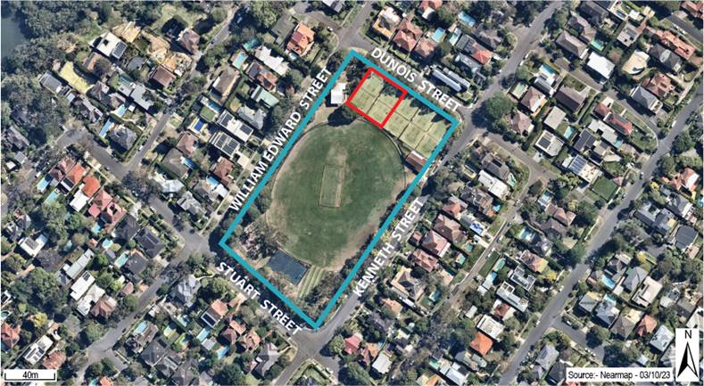
Figure 1
– Aerial Photograph of Site
3. APPLICATION
HISTORY
|
Date
|
Description
|
|
21 July 2003
|
DA39/2003
approved for the demolition of
existing cricket wickets and installation of new wickets.
|
|
27 August 2008
|
DA151/2008
approved for the installation of 2 underground rainwater tanks.
|
|
23 October
2023
|
Subject
Development Application lodged.
|
|
29 November
2023
|
Additional
information relating to lighting and acoustics submitted by the applicant.
|
|
30 November
2023
|
Evening site
inspection undertaken by author of this report.
|
4. PROPOSED
DEVELOPMENT
The Development Application is for the
installation of tennis court lighting on two (2) tennis courts at Kingsford
Smith Oval, Longueville.
The two (2) tennis courts are known as Courts 4
and 5 and are part of an ongoing lease of five (5) tennis courts to Longueville
Tennis Club by Lane Cove Council. Courts 4 and 5 are the courts available for
public hire.
The proposed lighting structure consists of six
(6) light poles ranging in height between 8m and 9m.
The proposed lighting comprises two LED lights on
each of the two (2) centre poles, and one LED light on each of the four (4)
outer poles.
The proposed lighting is proposed to be installed
with louvres to reduce light spill.
The proposed
development seeks to provide illumination to 9pm daily (with a dimming period
to allow for exiting patrons to 9:10pm).
The Development Application also seeks extension
of the hours of operation of Court 4 and 5 to 9:10pm, 7 days a week.
The lighting will allow between one (1) and four
(4) hours additional hours of operation depending on sunset. Sunset is as late
as 8:00pm during Summer (a one hour increase) and as early as 5:00pm in winter
(a four hour increase).
No vegetation is proposed to be removed.
5. SECTION
4.15(1) ASSESSMENT
The following subsections provide an assessment
of the proposal against the relevant heads of consideration under Section
4.15(1) of the Environmental Planning and Assessment Act, 1979.
5.1 Any
Environmental Planning Instrument (Section 4.15(1)(a)(i))
5.1.1 Lane Cove Local
Environmental Plan 2009
The proposed
development is permissible with consent in the RE1 Public Recreation zone
pursuant to Lane Cove Local Environmental Plan 2009 (LEP) being lighting
associated with a recreation facility (outdoor) as defined by the LEP.
No development
standards (height of building, floor space ratio etc.) apply to the site under
the LEP.
The site
contains local heritage item no. I274 in Schedule 5 of the LEP which is
identified as the clubhouse and scoreboard. The proposed development has been
reviewed by Council’s Heritage Advisor and no objection is raised on
heritage grounds. Accordingly, the proposed development is considered to
satisfy the relevant provisions of Clause 5.10 of the LEP.
5.1.2 State Environmental
Planning Policy (Biodiversity and Conservation) 2021
Chapter 6 – Water
Catchments of State Environmental Planning Policy (Biodiversity and
Conservation) 2021 (SEPP BC) applies to the Site as it is located within
the Sydney Harbour Catchment.
The consent
authority can be satisfied as to the relevant jurisdictional matters and
matters for consideration in Chapter 6 of SEPP BC through the provision of
appropriate erosion and sediment control which is a recommended draft condition
of consent.
5.1.3 State Environmental
Planning Policy (Resilience and Hazards) 2021
The proposed
development continues the recreational use of the land and is considered
satisfactory with respect to land contamination considerations under Chapter 4
of State Environmental Planning Policy (Resilience and Hazards) 2021 (SEPP
RH).
5.1.4 State Environmental
Planning Policy (Sustainable Buildings) 2021
State
Environmental Planning Policy (Sustainable Buildings) 2021 (SEPP SB) does not apply as the capital investment value is not
greater than $5 million (refer to Section 3.1(1) of SEPP SB).
5.2 Any
Proposed Instrument (Section 4.15(1)(a)(ii))
N/A
5.3 Any
Development Control Plan (Section 4.15(1)(a)(iii))
5.3.1 Lane Cove Development
Control Plan 2009
Planning
Assessment
There are no
specific DCP provisions specific to lighting of a public tennis court. Part C
of the DCP includes controls relating to the lighting of tennis courts within
residential development as follows:
Courts are
not to be illuminated beyond the hours of use between 7am to 8pm daily.
The DCP control
does not have any reference to lighting standards.
The proposed
development seeks to provide illumination to 9pm daily (with a dimming period
to allow for exiting patrons to 9:10pm).
Further
discussion of the proposed lighting is provided in Section
5.6 of this report.
Referrals
|
Referral
Officer
|
DCP Section
|
Assessment
|
|
Development
Engineer
|
Part O –
Stormwater Management
|
Council’s Development Engineer has
reviewed the proposed development and raises no objections subject to
recommended draft conditions.
|
|
Environmental
Health
|
Part S –
Environmental Sustainability
Part C1
– Tennis Court Lighting (Merit)
|
Part S of the
DCP does not apply as the cost of works does not exceed $250,000.
Council’s
Environmental Health Officer has reviewed the proposed development in
relation to acoustics and lighting and raises no objection subject to
recommended draft conditions including compliance with AS 4282 –
Control of the obtrusive effects of outdoor lighting.
|
|
Bushland
Coordinator
|
Part H –
Bushland
|
Part H of the DCP does not apply as the site is
not bushland or adjoining bushland. Notwithstanding, Council’s Bushland
Coordinator has reviewed the proposal and raises no objections subject to
recommended draft conditions including the requirement for suitable erosion
and sediment control measures during construction.
|
|
Heritage
Advisor
|
Part B9 -
Heritage
|
Council’s Heritage Advisor has reviewed
the proposed development and raises no objection on heritage grounds.
|
|
Community
Services
|
-
|
Council’s Community Services section have
reviewed the proposed development and raise no objection in relation to
compliance with the Plan of Management.
|
5.4 Any
Planning Agreement (Section 4.15(1)(a)(iiia))
N/A
5.5 Regulations
(Section 4.15(1)(a)(iv))
Section 66A of
the Environmental Planning and Assessment Regulations 2021 provides
requirements for Council-related development applications:
66A Council-related development
applications—the Act, s 4.16(11)
(1) A council-related development application must not be
determined by the consent authority unless—
(a) the council has adopted a conflict of interest
policy, and
(b) the council considers the policy in determining the
application.
(2) In this section—
conflict of interest policy means a policy that—
(a) specifies how a council will manage conflicts of
interest that may arise in connection with council-related development
applications because the council is the consent authority, and
(b) complies with the Council-related Development
Application Conflict of Interest Guidelines published by the Department
and available on the NSW planning portal, as in force from time to time.
Lane Cove
Council’s ‘Managing Conflicts of Interests for council-related
developments policy’ has been met in the circumstances of this case
through the report being prepared by an independent assessment officer and
referral for determination of the development application to the Lane Cove
Local Planning Panel.
5.6 Likely
Impacts (Section 4.15(1)(b))
Lighting
Impacts
The Development
Application seeks to light Court 4 and 5 in the evening period until 9pm daily.
(with a dimming period to allow for exiting patrons to 9:10pm).
Currently
Kingsford Smith Oval has limited security lighting on existing buildings but is
otherwise not illuminated.
The Development
Application is accompanied by a lighting assessment demonstrating compliance
with AS/NZS 4282:2019 – Control of the obtrusive effects of outdoor
lighting including lighting levels at adjoining
dwelling houses.
The lighting
assessment also demonstrates that the lighting complies with the minimum
luminance required for court lighting systems for club tennis under AS2560.2:2021
Sports Lighting.
Both assessments
demonstrate that the lighting level required for the tennis courts can be
achieved without resulting in adverse outdoor lighting effects at neighbouring
residential properties.
It is noted that
Chapter 2 of SEPP (Transport and Infrastructure) 2021 (SEPP TI) has two
provisions that allow a public authority (which includes a council) to install
lighting via different planning pathways.
Division 4 of
Chapter 2 relates to exempt development. Section 2.21 provides that exempt
development carried out by public authorities for purposes in Schedule 1 can be
carried out as exempt development subject to certain criteria. Schedule 1
allows for development of lighting (construction or maintenance) to be
undertaken as exempt development subject to:
Construction
and maintenance of external lighting if light spill is contained within site
and in accordance with AS 4282–1997, Control of the obtrusive effects of
outdoor lighting.
It is noted that
the above Australian Standard has been updated to 4282-2019. There are also
other general requirements for exempt development in section 2.20 that need to
be met to be exempt development including the following subsection:
(e) if it is likely to affect a State or local heritage item
or a heritage conservation area, must involve no more than minimal impact on
the heritage significance of the item or area, and
Division 12 of
Chapter 2 relates to development for parks and other public reserves and
includes provisions where development can be carried out without consent (i.e.
an authorisation under Part 5 of the EP&A Act). Relevantly, Section
2.73(3)(a)(iv) provides that “development may be carried out by or on
behalf of a public authority without consent on land owned or controlled by the
public authority” including development for lighting subject to the
following:
if
light spill and artificial sky glow is minimised in accordance with the
Lighting for Roads and Public Spaces
Standard.
This Standard is
not directly relevant as it does not provide standards relating to the
illumination of a public tennis court (i.e. Table 2.3 of AS/NZS 1158.3.1:2005
does not list any relevant or equivalent).
Both planning
pathways require a degree of merit assessment and for robustness of decision
making a development application has been submitted. The above provisions are a
useful assessment tool for lighting impacts.
The DCP control
which limits lighting to 8pm for tennis courts on a residential dwelling house
site is also useful for assessment. An extension by 1 hour (compared to
the DCP control) is considered reasonable in the circumstances of this case as
follows:
· The
courts are not directly abutting any residential property being separated by
the road reserve. This provides a separation of about 28m to Dunois Street
properties and 52m to William Edward Street properties. The 8pm DCP control
relates to circumstances where the relationship between a tennis court and
adjoining properties would be much closer, and does not contain lighting
standards;
· The
proposed development complies with the Australian Standards relevant to lighting
(one of which is the standard used in SEPP (TI)); and
· It
will allow for the use of a recreational facility within reasonable hours that
will not have an adverse impact on the acoustic amenity of any sensitive
receivers.
Notwithstanding,
given the non-illuminated nature of the site presently it is recommended that
no lighting be permitted on Sunday to provide a respite period to adjoining
dwelling houses.
Acoustic
Impact
The Development
Application is accompanied by an acoustic impact assessment which assesses the
acoustic impacts of the proposed extended hours of operation to 10pm against
the NSW EPA Noise Policy for Industry 2017 (NPfI).
Notwithstanding,
for the purpose of the DA the proposed hours of operation are to 9pm only for
lighting and an additional 10minutes for patrons to depart.
The acoustic
assessment considered noise impacts such as general patron activity such as
talking, shouting and the playing of tennis up to a maximum of eight (8)
persons (four (4) per court).
The acoustic
impact assessment considered the impacts to the following receivers:
· R1
– 101 William Edward Street, Longueville
· R2
– 23, 25 and 27 Dunois Street, Longueville; and
· R3
– 67, 69, 71 and 73 Kenneth Street, Longueville.
The following
table is replicated from the acoustic report (Table 6-1) which provides the
following assessment:
|
Measured Source Noise Levels
|
Calculated SPL at affected point of residential premises
|
Time of Day
|
Project Noise Trigger Levels
LAeq15min
|
Complies
|
|
LAeq15min
45 dB(A) at 10m
|
29 dB(A) at R1
36 dB(A) at R2
<35 dB(A)
at R3
|
6:30pm to 8pm
|
42
|
Yes
|
|
8pm to 9pm
|
40
|
Yes
|
|
9pm to 10pm
|
38
|
Yes
|
The applicant
was requested to provide additional information in relation to the location of
the noise monitoring device along Kenneth Street.
The acoustic
consultant provided a response that stated that the noise environment was
likely to be similar with marginal difference in background noise level
readings from its location adjacent to Kenneth Street.
The acoustic
consultant confirmed, that notwithstanding, even if the NPfI minimum background
noise level criteria was used, the proposed development would be acceptable.
The NPfI has a minimum background noise level criteria of 30dB(A), resulting in
a maximum level of 35dB(A) at the receivers. As per column 2 of the above
table, 35dB(A) would be exceeded by a maximum of 1dB(A) at Receiver 2 only. The
acoustic consultant stated this is considered to be with an accepted level of
tolerance and not discernable by the average listener.
The acoustic
impact assessment includes recommendations relating to signage for users of the
tennis court and the requirement to implement a complaints procedure.
Ecology
The Development
Application is within a public reserve and does not propose to remove
vegetation.
The Development
Application is accompanied by an ecological assessment which concludes as
follows:
The
proposal impacts a very small area of habitat that is suitable for a number of threatened
and protected species. No vertebrate fauna species would be significantly impacted.
Small shifts in behaviour are likely during hours of illumination, however these
shifts should not impact the ability of any species, or even any
individual, to persist in the area.
Traffic and
Parking
The proposed
development will extend the parking and traffic impacts of the existing use of
Courts 4 and 5 to 9:10pm daily, noting this is likely to be a decrease from the
daytime when five courts are in usage. It is unlikely that the use of the
courts for this period will result in any adverse traffic or parking impacts.
A maximum of
eight persons would be attending the site (in accordance with the acoustic
report and as reflected in a recommended operational draft condition of
consent). This results in a maximum of four vehicle trips per court. The
minimum booking time is one hour. Accordingly, the maximum additional vehicle trips
per court per hour is eight (being four in/four out).
5.7 Site
Suitability (Section 4.15(1)(c))
The site is
suitable for the proposed development. The proposed development will allow for
an extension to the use of Courts 4 and 5 under the terms of the existing lease
to the Longueville Tennis Club. Having regard to the site’s residential
context it is recommended that no lighting be permitted on a Sunday.
5.8 Submissions
(Section 4.15(1)(d))
The Development
Application was notified in accordance with the Community Participation Plan. A
total of 52 submissions were received including three (3) in support and 49
objections. The following table summarises the objections received.
|
Concern or Comment
|
Comment
|
|
Light
impacts – Concerns relating to light
impacts on neighbours and locality.
|
Refer to Section
5.6 of this assessment report.
|
|
Noise
impacts – Concerns relating to suitability
of noise assessment and acoustic impacts on neighbours.
|
Refer to Section
5.6 of this assessment report.
|
|
Carparking, traffic and pedestrian
safety – Concerns relating to parking and
traffic.
|
Refer to Section
5.6 of this assessment report.
|
|
Hours of operation – Concerns relating to hours of operation including
potential for 10pm operation.
|
The proposed
lighting will not extend beyond 9:00pm with reduced exit lighting allowed
until 9:10pm. Restriction to 8pm (as per the requirements for dwelling
houses) is not considered a reasonable standard to apply in the circumstances
of this case as outlined in Section 5.6 of this assessment report.
|
|
Ecology – Concerns regarding ecological impacts and suitability of
ecology report.
|
The proposed
development does not remove any vegetation. The ecologist report covers a
number of proposed design scenarios including the design within the subject
DA. The conclusions of the assessment are outlined in Section 5.6 of
this assessment report.
|
|
Dimmers – The lights should include dimmers to reduce light spill
and glare. The lights should be turned down when the courts are not in use.
|
The
installation of dimmers, and the switching off of lighting when the court is
not in use, forms a recommended draft conditions of consent.
|
|
Screening
– Further screening of lights and noise
should be implemented.
|
The light or
acoustic assessment does not require the implementation of any additional
physical screening measures to comply with the applicable lighting and noise
criteria.
|
|
Height of
the Lighting
|
The LEP does
not contain a building height development standard for the site.
The light
poles have a maximum height of 9m which is below the 9.5m building height
development standard of the LEP for the adjacent residential zoned land.
|
|
Demand for Outdoor Activities, Tennis
as an Outdoor Activity and Need for Additional Night Tennis Opportunities
|
The impacts of
the proposed lighting have been considered in this report and found to be
reasonable subject to recommended draft conditions of consent. The provision
of extended tennis opportunities is considered reasonable in this location.
Any diversion of demand from the site to other facilities within the LGA
would mean the impacts are further reduced. That is, the lighting is not
permitted to be on if the courts are unoccupied.
|
|
Submissions
in Support
|
Submissions in
support say the proposal would allow for more recreational and employment
opportunities with minimal environmental impacts.
|
5.9 The Public
Interest (Section 4.15(1)(e)
The Development Application is in the public interest
including the proposed development’s consistency with the objectives of
the RE1 Public Recreation zone.
· To
enable land to be used for public open space or recreational purposes.
· To
provide a range of recreational settings and activities and compatible land
uses.
· To
protect and enhance the natural environment for recreational purposes.
· To
make provision for rights of public access to more foreshore land and to link
existing open space areas.
The proposal enables the land to be used for recreational
purposes and does not detract from the natural environment for recreation
purposes.
6. Council-Related
Development Application
Schedule 1 of the EP&A Act includes the following for
Council-related development applications:
9B Council-related development applications
(1) Minimum public exhibition period for a council-related
development application—28 days.
(2) In this clause—
council-related development application means a development
application, for which a council is the consent authority, that is—
(a) made by or on behalf of the council, or
(b) for development on land, other than a public road
within the meaning of the Local Government Act 1993—
(i) of which the council is an owner, a lessee or a
licensee, or
(ii) otherwise vested in or under the control of the
council.
Note—
Land vested in or under the control of the council includes public
land within the meaning of the Local Government Act 1993.
The land is vested in or under the control of the council
and accordingly a minimum public exhibition period of 28 days applies. The DA
was renotified for a period of 28 days in accordance with Schedule 1 of the
EP&A Act.
6. Plan of
Management
In accordance with the Lane Cove Community Land
Plan of Management (POM), Kingsford Smith Oval is land owned by the Crown which
is managed by the Council under the Crown Land Management Act 2016.
Kingsford Smith Oval is managed as a sportsground
in accordance with the Plan of Management. The proposed development is
consistent with the core objectives in Section 3.2 of the POM:
a) to encourage, promote and facilitate
recreational pursuits in the community involving organised and informal
sporting activities and games, and
b) to ensure that such activities are managed
having regard to any adverse impact on nearby residences.
The Development Application will promote
recreational pursuits and is accompanied by adequate supporting documentation
to demonstrate the activities will not have any adverse impact on nearby
residences.
CONCLUSION
The matters in
relation to Section 4.15 of the Environmental Planning and Assessment Act 1979
have been satisfied.
Whilst there are
no controls in the applicable environmental planning instruments (EPIs) and
Lane Cove DCP that control light, this assessment has had regard to other EPIs
that do contain such standard for different planning pathways. In
addition, the assessment also has regard for the time limitation for illumination
of tennis courts in Part C Residential Development of the Lane Cove Development
Control Plan 2009.
The proposal has
been found to comply with the relevant light standards and acoustic standards
and on that basis is not considered to have an adverse impact on adjoining
properties. Other impacts such a traffic, parking and ecological impacts have
been found to be minor and acceptable.
The illumination
of 2 of the 5 courts will improve opportunities for the community to use the
recreation facility making good use of a public asset.
On balance as
the proposed development would be reasonable it is therefore recommended for
approval.
|
RECOMMENDATION
That pursuant to Section 4.15
of the Environmental Planning and Assessment Act 1979, the Lane Cove Local Planning
Panel, exercising the functions of Council as the consent authority, grants
development consent to Development Application 116/2023 for Construction
of lighting for two tennis courts (numbers 4 and 5) at Kingsford Smith Oval,
Longueville, subject to the following conditions:
PART A
– GENERAL CONDITIONS
1. A.1 –
Approved plans and supporting documentation
Development must be carried out in accordance with the following
approved plans and supporting
documentation (stamped by Council), except
where the conditions of this consent
expressly require otherwise.
|
Drawing
No
|
Plan
Title
|
Drawn By
|
Dated
|
|
A.01
|
Full Site
Plan
|
-
|
30 October
2023
|
|
A.02
|
Partial Site
Plan, Courts
|
JR
|
30 October
2023
|
|
B.01
|
Proposed
North Elevation
|
JR
|
30 October
2023
|
|
B.02
|
Proposed
West Elevation
|
JR
|
30 October
2023
|
|
Document
Title
|
Version
No.
|
Prepared
By.
|
Dated
|
|
Obtrusive Light Report
|
22089-02-B
|
Apex
Lighting
|
-
|
|
Obtrusive Light Report Calculations
|
22089-03
|
Apex
Lighting
|
29 September
2023
|
|
DA Acoustic Assessment
|
12466 R01v1
|
PKA Acoustic Consulting
|
25 November
2022
|
|
Environmental
Assessment
|
-
|
Applied
Ecology
|
23 November
2022
|
In the event of any inconsistency between the approved plans and a
condition of this consent, the condition prevails.
Reason: To ensure all parties are aware of the approved plans and
supporting documentation that applies to the development.
2. A.12 –
Construction Certificate
The submission of a Construction Certificate and its issue by
Council or Principal Certifier PRIOR TO CONSTRUCTION WORK commencing.
Reason: To ensures the detailed construction plans and specifications comply
with the requirements of the Building Code of Australia (BCA) and any
relevant Australian Standard.
3. A.3
– Payment of security deposits (if
applicable)
Before the commencement of any works on the site or the issue of a
construction certificate, the applicant must make all of the following
payments to Council and provide written evidence of these payments to the
Certifier:
|
-
Security deposit
|
-
Revision
|
|
-
Infrastructure
Damage Bond
|
-
$4000
|
A $4000.00 cash bond or bank guarantee shall be lodged with
Council to cover the satisfactory construction of the above requirements.
The payments will be used for the cost of:
· making good any damage caused to any council property (including
street trees) as a consequence of carrying out the works to which the
consent relates.
· completing any public work such as roadwork, kerbing and
guttering, footway construction, stormwater drainage and environmental
controls, required in connection with this consent.
Reason: To ensure any damage to public infrastructure is rectified
and public works can be completed.
4. A.9.T Works
on Council land
Separate application shall be made to Council’s Urban and
Services Division if there is any associated works on Council property.
Written approval is to be obtained prior to the start of any works on Council
property.
Reason: To manage impacts to Council’s assets.
(b)
PART B – PRIOR TO ISSUE OF CONSTRUCTION CERTIFICATE
5. Construction
Management Plan
The applicant must submit a construction plan of management to the
satisfaction of Council including an erosion and sediment control plan
prepared by a suitably qualified hydraulic engineer prior to the issue of a
Construction Certificate.
Reason: To manage impacts to Council’s assets and waterways.
(c)
PART C – BEFORE THE
COMMENCEMENT OF BUILDING WORK
6. C.1
– Erosion and sediment controls in place
Before the commencement of any site or building work, the
principal certifier must be satisfied the erosion and sediment controls in
the erosion and sediment control plan, (as approved by the principal
certifier) are in place until the site is rectified (at least 70% ground
cover achieved over any bare ground on site).
Reason: To ensure runoff and site debris do not impact local
stormwater systems and waterways.
PART D
– WHILE BUILDING WORK IS BEING CARRIED OUT
7. D.1 –
Hours of work
The principal certifier must ensure that building work is only
carried out between:
Monday to Friday (inclusive) 7.00am
to 5.30pm
Saturday 7.00am
to 4.00pm
With NO high noise generating activities, to be undertaken after
12 Noon on Saturday.
A Notice/Sign showing permitted working hours and types of work
permitted during those hours, including the applicant’s phone number,
project manager or site foreman, shall be displayed at the front of the site.
The principal certifier must ensure building work, demolition or vegetation
removal is not carried out on Sundays and public holidays, except where there
is an emergency.
Reason: To protect the amenity of the surrounding area.
8. D.7 –
Construction noise
While building work is being carried out where no noise and vibration
management plan is approved under this consent, the applicant is to ensure
that any noise caused by demolition, vegetation removal or works does not
exceed an Laeq (15 min) of 5dB(A) above background noise, when measured at
any lot boundary of the property where these works are being carried out.
Reason: To protect the amenity of the neighbourhood.
9. E.18.B
– No obstruction of public way
The public way and Council verge must not be obstructed by any
materials, vehicles, refuse, skips or the like, under any circumstances.
Non-compliance with this requirement will result in the issue of a notice by
Council to stop all work on site.
Reason: To ensure public safety.
(d)
PART E – BEFORE THE
ISSUE OF AN OCCUPATION CERTIFICATE
10. E.1
– Works-as-executed plans and any other documentary evidence
Before the issue of the relevant occupation certificate, the
applicant must submit, to the satisfaction of the principal certifier,
works-as-executed plans, any compliance certificates and any other evidence
confirming the following completed works:
The following matters that Council requires to be documented:
· Certification from suitable licensed contractor that all works
have been constructed satisfying relevant Australian standards (including lighting
standards).
· Certification from qualified structural engineer that the proposed
construction has been completed according to approved plan and structurally
certified.
The principal certifier must provide a copy of the plans to
Council with the occupation certificate.
Reason: To confirm that the proposed works have been constructed
satisfactorily as per approved plans
PART F
– OCCUPATION AND ONGOING USE
11. Operational Restrictions
- Noise Management
The use of the tennis courts 4 and 5 is subject to the following
restrictions when illuminated:
· The on-line booking facility is to advise patrons to be mindful of
nearby residences when arriving and leaving.
· Appropriate signage is to be provided reminding patrons to conduct
themselves in an orderly manner at all times and to limit excessive noise.
· a maximum of four (4) persons per court at any one time;
· Amplified music/announcements is not permitted.
Reason: protect the amenity of the neighbourhood.
12. Operational Restrictions
of Lighting
The use of the tennis court lighting is subject to the following
restrictions:
· Lighting is permitted between 7am to 9pm, Monday to Saturday;
· The court(s) are only to be illuminated when they are being used
for playing tennis. The lighting is to be installed to allow the courts to be illuminated individually so that if one of
the courts is not in use, that court is not illuminated.
· Compliance with AS/NZS 4282 –
Control of the obtrusive effects of outdoor lighting (with the version being as applicable at time of issue of the
Construction Certificate);
· Lighting is to be turned off when the tennis court is not in use;
· Lighting is to be in accordance with the lighting specifications
(including BL1 louvres) detailed in the Longueville Tennis Club Obtrusive
Light Report and Calculations prepared by Apex Lighting submitted with the
Development Application.
· Dimmers are to be installed with appropriate monitoring technology
so that the illumination does not exceed an average 350 lux with a tolerance
of +5%.
· Dimmers are to also automatically reduce the lux at 9pm before
switching off the lighting at 9:10pm
Reason:
protect the amenity of the neighbourhood.
13. H.1 - Release of
securities / bonds
When Council
receives an occupation certificate from the principal certifier, the
applicant may lodge an application to release the securities held in
accordance with Condition 3. Council may use part, or all of the
securities held to complete the works to its satisfaction if the works do not
meet Council’s requirements.
Reason: To
allow release of securities and authorise Council to use the security deposit
to complete works to its satisfaction.
|
ATTACHMENTS:
There are no supporting documents for this report.