Logo Watermark


Agenda

Lane Cove Local Planning Panel Meeting

27 March 2024  


LC_WebBanner


Notice of Meeting


Dear Panel Members,


Notice is given of the Lane Cove Local Planning Panel Meeting, to be held in the Council Chambers  on Wednesday 27 March 2024 commencing at 5pm. The business to be transacted at the meeting is included in this business paper.


Yours faithfully

Craig - GM

Craig Wrightson

General Manager


Lane Cove Local Planning Panel Meeting Procedures


The Lane Cove Local Planning Panel (LCLPP) meeting is chaired by Mr Mark Gifford. The meetings and other procedures of the Panel will be undertaken in accordance with the Lane Cove Lane Cove Local Planning Panel Charter and any guidelines issued by the General Manager.

The order of business is listed in the Agenda on the next page. That order will be followed unless the Panel resolves to modify the order at the meeting. This may occur for example where the members of the public in attendance are interested in specific items on the agenda.

Members of the public may address the Panel for a maximum of 3 minutes.  All persons wishing to address the Panel must register prior to the meeting by contacting Council’s Office Manager – Environmental Services on 9911 3611. Where there are a large number of objectors with a common interest, the Panel may, in its absolute discretion, hear a representative of those persons.

Minutes of LCLPP meetings are published on Council’s website www.lanecove.nsw.gov.au as soon as possible following the meeting. If you have any enquiries or wish to obtain information in relation to LCLPP, please contact Council’s Office Manager – Environmental Services on 9911 3611.

Please note meetings held in the Council Chambers are Webcast. Webcasting allows the community to view proceedings from a computer without the need to attend the meeting. The webcast will include audio of members of the public that speak during the meeting. Please ensure while speaking to the Panel that you are respectful to other people and use appropriate language. Lane Cove Council accepts no liability for any defamatory or offensive remarks made during the course of these meetings.

The audio from these meetings is also recorded for the purposes of verifying the accuracy of the minutes and the recordings are not disclosed to any third party under the Government Information (Public Access) Act 2009, except as allowed under section 18(1) or section 19(1) of the PPIP Act, or where Council is compelled to do so by court order, warrant or subpoena or by any other legislation.


Lane Cove Local Planning Panel 27 March 2024

TABLE OF CONTENTS


DECLARATIONS OF INTEREST


APOLOGIES


NOTICE OF WEBCASTING OF MEETING


Lane Cove Local Planning Panel Reports


1.      2 Manns Avenue Greenwich................................................... 4


2.      266 Longueville Road, Lane Cove - s4.55 Modification of Consent................................................................................. 39


Orders Of The Day


Lane Cove Local Planning Panel   27 March 2024

2 Manns Avenue Greenwich


Subject:          2 Manns Avenue Greenwich     

Record No:    DA23/93-01 - 70444/23

Division:         Planning and Sustainability Division

Author(s):       Christopher Shortt 


Property:

2 Manns Avenue Greenwich

DA No:

DA93/2023

Date Lodged:

03/08/2023

Cost of Work:

$900,000

Owner:

Mrs Diana Yueying Wang

Applicant:

AGC Architects PTY Ltd – Andrew Chen


Description of the proposal to appear on determination

Proposed demolition of existing dwelling house and construction of 2-storey dwelling with sub-level garage.

Zone

R2 Low Density Residential

Is the proposal permissible within the zone

Yes

Is the property a heritage item

No

Is the property within a conservation area

Yes

Does the property adjoin bushland

No

BCA Classification

Class 1a and 10b

Stop the Clock used

No

Notification

Notified as per Council’s policy. All submissions have been sent to the LPP members for consideration as part of the assessment.


1st notification 03/08/23 – 19/08/23.

A total of 11 submissions were received.


2nd notification amended plans 25/10/23 – 14/11/24.

A total of 6 submissions received. 


3rd notification amended plans 28/02/24 – 15/03/24.

No submissions received.


All submissions have been provided to the Panel.


REASON FOR REFERRAL


The proposal is referred to the Lane Cove Local Planning Panel as more than 10 unique submissions were received as a result of the notification period.  The proposal is therefore considered to be a contentious development application.


1.         EXECUTIVE SUMMARY


The subject Development Application is for proposed demolition of existing dwelling house and construction of 2-storey dwelling with sub-level garage. The dwelling house is located in the Greenwich Heritage Conservation Area but is not listed as a heritage item.


The Development Application was notified in accordance with Council policy three times as the design was modified twice after lodgment.  A total of 17 submissions (including 1 from the Lane Cove Heritage Society) were received across the 3 notification periods. The submission concerns include, but are not limited to, view loss, building appearance and impacts on heritage conservation area, shadows, quality of documentation submitted, excavation, stormwater impacts among others. The submissions are addressed in the report in more detail. The Development Application is reported to Lane Cove Local Planning Panel (LPP) with a recommendation for approval subject to draft conditions as the amended design is fully compliant with Council’s LEP controls and generally compliant with Council’s DCP controls. The applicant, through multiple design changes has adequately demonstrated that the proposal would comply with the Tenacity View Sharing Principles in NSW Caselaw and would be an acceptable replacement dwelling house within the Greenwich Heritage Conservation Area.


2.         REASON FOR REFERRAL TO THE LOCAL PLANNING PANEL


The subject Development Application is referred to the Lane Cove Local Planning Panel (LCLPP) in accordance with the Local Planning Panels Direction under Section 9.1 of the Environmental Planning and Assessment Act, 1979 Planning Direction dated 6 September 2023 with respect to it:


·    Having more than 10 unique submissions were received as a result of the notification period.  The proposal is therefore considered to be a contentious development application.


SITE

The site is located on the western side of Manns Avenue and is legally described as Lot. 1, DP. 527499. The site is located at the corner of Manns Avenue and Gother Avenue and has a secondary frontage to Gother Avenue. The site has a moderate fall of approximately 3m in natural ground level from the western boundary to the eastern boundary. The site is irregular in shape with an area of approximately 682.9sqm. The site contains a single-storey dwelling house.


·    Neighbouring sites south and west of the property are exclusively residential.

·    Directly south of the site is 4 Manns Avenue which is a part 2 and part 3-storey dwelling south.

·    East and north of the site is Gother Lane.

·    Further east and north is a site zoned Working Waterfront and is inhabited by the Shell Oil industrial site. The Shell site contains storage tanks and carparking on site. Further east is the Lane Cove River.

·    West of the site is Manns Avenue. Further west are single, two and part 3-storey dwellings houses.


Figure: 1. Satellite image location plan (Nearmap).

Figure 2: Heritage map. (LCLEP 2009).         Figure 3: Zoning Map. (LCLEP 2009).

Figure 4: Site viewed from Manns Avenue.

Figure 5: Site viewed from Gother Avenue.


SITE APPLICATION HISTORY

A search of Council’s records revealed no recent application associated with the site.


PROPOSAL

Demolition of existing single-storey dwelling house and construction of a proposed two-storey dwelling house with sub-ground car parking.  Works include:


Basement level: (RL 18.5) Excavation to accommodate basement level garage and lift/stairs access to ground floor.

Ground floor: (RL 21.2) Open plan living, dining and kitchen, pantry room, laundry room, guest room, master bedroom with walk-in robe and ensuite, BBQ terrace.

1st floor: (RL 24.1) 3 x bedroom, 2 x ensuite, walk-in-robe, tea-room, lounge room, bathroom, rear balcony.

Roof: (RL 27.100). Flat roof.


After discussions with Council relating to view impacts the design was amended. Changes include:

·    The 1st floor setback increased from 1.5m to approximately 10m from the southern boundary with 4 Manns Avenue;

·    Reduction of proposed 1st floor GFA from 144.1sqm to 105.6sqm;

·    Consolidate the proposed 1st floor balcony area to the eastern side of the building (Fronting Gother Avenue);

·    Reallocate GFA from 1st floor to ground floor by reducing ground floor setback to the northern boundary (Gother Avenue) from 5.366m to 2m;

·    The 1st floor projecting slab beyond the front building setback was reduced from 4.5m to 1.8m; and

·    Swimming Pool has been removed.


PROPOSAL DATA/POLICY COMPLIANCE


Local Environmental Plan 2009


Zoning: R2 Low Density                               Site Area: 682.9m²


LEP table


Development Standard

Proposal

Complies

Floor Space Ratio (max)

0.5:1


(341.45sqm)


0.498:1


(340.1sqm)

  Yes

Height of Buildings (max)

9.5m

7.53m

  Yes

Clause 5.10


Heritage Conservation

The consent authority must, before granting consent under this clause in respect of a heritage item or heritage conservation area, consider the effect of the proposed development on the heritage significance of the item or area concerned.

The site is not a heritage item but is located within the Greenwich Heritage conservation area.


The proposal included a Heritage Impact Statement (HIS) prepared by a qualified heritage consultant.


The design was amended to provide greater articulation and with finishes and colours more sympathetic with the heritage conservation area.


The proposal was modified to reduce bulk and would result in approximately 30% of the building is single-storey when viewed from the Manns Street frontage.


The amended design was referred to Council’s heritage officer who stated:


the amended design has addressed all the above conditions and my concerns regarding the previous proposals’


Refer to referral section for expanded detail

Yes


Comprehensive Development Control Plan assessment


DCP table


Provision

Proposal

Complies

Front setback (min)

Consistent with area or 7.5m


The existing building is 7.72m from front boundary and sits behind the rock wall.


The neighboring property at 4 Manns Avenue has a similar front building wall setback approximately 7.75m


The site is irregular-shaped and the northern side boundary is only 15.2m in depth.


The proposed building is to be setback 7.5m setback from Manns Avenue frontage. This is generally consistent with the setback of the neighbour.


It is noted that proposed dwelling is significantly smaller in scale than the neighbour at 4 Manns and would be less imposing than most properties within the streetscape. The proposed setback is considered acceptable and supported in this instance.

Yes

Encroachments into 7.5m setback

In general, no part of a building or above ground structure may encroach into a setback zone. Exceptions are awnings, balconies, blade walls, bay windows and other articulation elements up to a maximum of 500mm. (i.e 7m)

Amended design 1st floor projecting slab to project up to 1.8m beyond the front building line.


A draft condition is recommended to reduce the projecting 1st floor slab to a maximum of 500mm beyond the front building wall to comply.

See variations section.


Secondary street setback (min) (corner lots)

2.91m

Minimum 2m setback from Gother Avenue.

Yes

Side setback (min)

1.2m single storey

1.5m two storey


Minimum side setback of 1.519m at GF and 1st F and 2m at secondary street setback

 Yes


Rear setback (min)

<1000m²: 8m or 25%


Site is less than 1000 sqm.


Irregular rear boundary to Gother Avenue.


Average of 2.91m and 17.191m =

10.05m


  Yes

Wall height (max)

7m + 600mm parapet for flat roof structures

6.98m

  Yes

Ridge height (max)

9.5m

7.53m

  Yes

Number of storeys (max)

2

2 storeys + basement

Yes

Landscaped area (min) (Minimum dimension of 1m)

35%

41%


Landscaped area increased as result of deletion of pool and patio.

  Yes

Foreshore setback line

Refer to B.5 Development in Foreshore Areas

The site is approximately 75m from the foreshore.

N/A

Cut and fill (max)

1m

1.18m

See variations section.

Solar access (min)

3 hours to north facing habitable windows

Minimum 3 hours solar access achieved

  Yes

Deck/balcony depth (max)

3m

Max balcony depth = 3.6m

See variations section.

Private open space (min)

24m² and 4m in depth

Greater than 24sqm

Yes

BASIX Certificate

Required

Submitted

  Yes


Car parking


Car parking table


Provision

Proposal

Complies

Off-street spaces (min)

1 (minimum)

2 vehicles

Yes

Driveway width

3m at the kerb

Driveway crossover is existing

N/A


Carports within the front setback & garages facing the street


Car parking structure table


Provision

Proposal

Complies

Setback of carport posts (min)

1m from street boundary

7m

  Yes

% of allotment width (garages & carports)

50% of lot width or 6m, whichever is the lesser

5.69m

  Yes

Fences


Fences table


Provision

Proposal

Complies

Front fence height (max)

Solid: 900mm

Lightweight: 1.2m (including up to 600mm solid bass)

Front fence solid base (600mm in height) +

light weight glass panels above (450mm in height)

Yes

Setback from front boundary if the height is over 1.2m (min)

1m

Approx. 17m from Gopher Avenue

Yes


View sharing:  


The view impacts of the proposed works have been assessed in accordance with the view

sharing principles established in Tenacity Consulting Pty Ltd v Warringah Council (2004) [NSWLEC 140].


An assessment against the Tenacity Planning Principles 2004 for view sharing from NSW Caselaw are detailed below.


1.   The first step is the assessment of views to be affected. Water views are valued more highly than land views. Iconic views (eg of the Opera House, the Harbour Bridge or North Head) are valued more highly than views without icons. Whole views are valued more highly than partial views, e.g a water view in which the interface between land and water is visible is more valuable than one in which it is obscured.


2.   The second step is to consider from what part of the property the views are obtained. For example the protection of views across side boundaries is more difficult than the protection of views from front and rear boundaries. In addition, whether the view is enjoyed from a standing or sitting position may also be relevant. Sitting views are more difficult to protect than standing views. The expectation to retain side views and sitting views is often unrealistic.


3.   The third step is to assess the extent of the impact. This should be done for the whole of the property, not just for the view that is affected. The impact on views from living areas is more significant than from bedrooms or service areas (though views from kitchens are highly valued because people spend so much time in them). The impact may be assessed quantitatively, but in many cases this can be meaningless. For example, it is unhelpful to say that the view loss is 20% if it includes one of the sails of the Opera House. It is usually more useful to assess the view loss qualitatively as negligible, minor, moderate, severe or devastating.


4.   The fourth step is to assess the reasonableness of the proposal that is causing the impact. A development that complies with all planning controls would be considered more reasonable than one that breaches them. Where an impact on views arises as a result of non-compliance with one or more planning controls, even a moderate impact may be considered unreasonable. With a complying proposal, the question should be asked whether a more skillful design could provide the applicant with the same development potential and amenity and reduce the impact on the views of neighbours. If the answer to that question is no, then the view impact of a complying development would probably be considered acceptable and the view sharing reasonable.


Principle

Assessment

Principle 1 -Type of views:


The assessment has primarily focussed on neighbours on the opposite side of the roadway at 21, 23 and 25 Manns Avenue who enjoy water views to the east, northeast and southeast to the Lane Cove River (Gore Cove), North Sydney CBD skyline, and the Sydney Harbour Bridge.

No’s 21, 23 and 25 all obtain views through the subject site.


21 Manns Avenue. Single storey dwelling house: Views from the dwelling house at 21 Manns Avenue (single storey dwelling house), to be affected are to the East and South-East, to Gore Cove waterway, Berry Island, the North Sydney CBD Skyline, and the Sydney Harbour Bridge

23 Manns Avenue. Two storey dwelling house: Views from the dwelling house at 23 Manns Avenue to Gore Cove across northern portion of the site with landscaped views of Berry Island and views towards the North Sydney CBD. 


25 Manns Avenue. Two storey dwelling house. Views from 25 Manns Avenue to be affected to the east and north-east towards the Lane Cove River (Gore Cove Waterway), Berry Island and the North Sydney CBD skyline.  


The eastern water views are onto the Gore Cove and beyond including North Sydney skyline as well as views southeast to the Sydney Harbour Bridge.


Principle

Assessment


Principle 2 - Where the views are obtained:


Council’s planner visited neighbouring properties to get an understanding of the views impacted.


·      21 Manns views enjoyed from the ground-floor living room, and dining room.


·      23 Manns Avenue views enjoyed from ground floor terrace, living room and bedroom 1st floor views from balcony/’look out’ and 1st floor bedroom.


·      25 Manns Avenue views enjoyed from ground floor front courtyard, 1st floor views from family room and 1st floor bedroom.


Principle 3 - The extent of the impact:

A site inspection by Council’s planner confirmed that water views are onto the Gore Cove and beyond including North Sydney skyline. 


21 Manns Avenue


Ground Floor: (RL:27.6) Water views from the ground floor living room, dining room and bedrooms would be impacted be the development. The foreshore and North Sydney skyline would be retained.


The original design included a 2-storey building encompassing the majority of the width of the site. The proposal was revised and setback the 1st floor 10m from the southern boundary to retain a south-eastern view corridor through to the Lane Cove River and Sydney Harbour Bridge/city skyline through foliage which is an iconic view. The amended 1st floor would still impact the views across the Lane Cove River to Gore Cove. These views are considered ‘secondary’ in terms of their importance as compared to the Harbour Bridge and City Skyline which are iconic views.


1st Floor: (RL 30.65) It is noted that 21 Manns received DA approval for upper-level addition which included a master bedroom and associated balcony and study room facing east towards the water. (Ref: 149/2022). The approved addition is likely to retain some water views across to Gore Cove as well as City views to the harbour Bridge.


23 Manns Avenue

Views from the dwelling at 23 Manns Avenue to be affected are to the east and north-east, across the front and rear boundaries of the subject site. Currently, the views obtained from this property over the site are towards the Gore Cove waterway, Berry Island, and the North Sydney CBD Skyline.


Ground Floor: (RL 27.83) Views from ground floor front terrace and attached family room.


1st Floor (RL: 30.98) Views from 1st floor balcony/’look out’ and 1st floor bedroom. The submitted view analysis diagrams based on the surveyed height poles confirm that significant water views to Gore Cove and the Lane Cove River would be retained as well as the North Sydney Skyline.


25 Manns Avenue

Ground Floor: (RL: 26.750)

Water views from front deck and attached study room, and family room would be impacted. The submitted view analysis diagrams based on the surveyed height poles confirm the amended design would retain a significantly larger portion of water views in the upper-level setback. The foreshore beyond would also be retained.


1st Floor: (RL 30.010) Water views retained from balcony, TV room and bedroom.


Principle 4 - Reasonableness of the proposal:

Planning Controls: The part of the proposal which affects views relates to the upper level.


The proposal complies with the relevant planning controls which define the bulk and scale of the dwelling including:


FSR: complies with the FSR control of 0.5:1.

HEIGHT: complies with height control. The maximum height is 7.53m and almost 2m below the permitted 9.5m height control.

REAR SETBACK: complies with rear setback line.

SIDE SETBACK: complies with the 1.5m side setback control.


The tenacity principles require that a more skilful design with the same development potential be explored to check if available.


Proposed design:

Although the original design complied with the height/FSR and setback controls, the proposal was further modified to reduce its overall bulk and scale and allow  view corridors for affected sites


The 1st floor setback was increased from 1.5m to approximately 10m from the southern boundary with 4 Manns Avenue.


The amended design increased the 1st floor setback to 10m from the southern boundary. The amended design of the 1st floor results in a section of the building being single-storey. The height would be reduced to approximately 4.75m above natural ground level for approximately 30% of the width of the Manns Avenue frontage.


Given that a maximum 9.5m height control, can be considered for the site, a building with heights between 4.75m – 7.53m is considered to be a sympathetic design.


The amended design would retain a south-eastern view corridor enjoyed by 21 Manns through to the Lane Cove River and Sydney Harbour bridge. However, the revised proposal would still impact water view corridors directly east to Gore Cove. In terms of view hierarchy of views:

·      The Sydney Harbour Bridge view is classified as an iconic view and is retained.

·      Part of water views to Gore Cove would be impacted, but is considered secondary and overall view sharing is retained.


It is noted that the approved but yet-to-be-built 1st floor addition at 21 Manns at RL 30.65 is likely to retain some water views across to Gore Cove as well as City views to the harbour Bridge.


The amendments are considered to be result in more skilful outcome as they are specifically designed to protect iconic views for the affected neighbours.


Figure 6: Amended design with sightline corridor retained after 1st floor reduced.

Figure 7: Original design with full 1st floor envelope.


REFERRALS


Development Engineer – Part O – Stormwater Management


No objections subject to recommended draft conditions.


Tree Assessment Officer – Part J – Landscaping


No objections subject to recommended draft conditions.


Heritage Officer


Council’s heritage officer raises no objection to the amended scheme. The heritage officer’s  comments are as follows:


I acknowledge receipt of amended drawings on 28 February 2024 and supporting letter from Chapman Planning for the proposed new residence.


I refer to my previous report on 11 September 2023 in which I recommended the following conditions:


I propose the following conditions of consent to mitigate potential impacts on the Conservation Area.

·    The scale and massing of the development should be reduced to offset the commercial character of the building;

·    A greater degree of articulation of the elevations should be achieved by reducing the          prominence of the fascia’s between floors and at roof level;

·    Walls are indicated on the plans as brickwork, which may be improved by a textured finish;

·    Colours should be muted to soften the strong contrast between the fascia and walls;

·    The existing stone garden walls should be retained as significant elements of the landscaping, as stated in the HIS.


The amended scheme has addressed all the above conditions and my concerns regarding the previous proposals, as follows:


·    The massing of the development has been considerably reduced by substantial cut-back of the upper floor level. The increased area of the ground floor has acceptable additional impact.

·    The depth and prominence of the fascia’s have been reduced by narrower depth at the outer edges.

·    The articulation of window openings has improved the elevational arrangement.

·    Masonry walls are proposed as a grey texture finish which is acceptable and neutral in colour. and

·    The stone wall is proposed to be retained.


The site is not a heritage item and is not adjacent to any heritage items.


The design was amended, and the 1st floor of the dwelling house has been setback approximately 10m from the southern boundary. The dwelling house would be partly single-storey, and partly two-storey when viewed from Manns Avenue. The scale and height of the building is significantly lower than all surrounding dwelling houses at 4 Manns and across the road at 23 and 25 Manns Avenue. 


The projecting floor slabs have been conditioned to be reduced to ensure the building is less prominent when viewed from Manns Avenue.


While within a heritage conservation area, the design as amended would not compromise the existing heritage character of the streetscape.


Most of the vegetation within the front setback of the property including eucalypt and callistemons are to be retained. Combined with Council’s Street trees the existing and proposed vegetation would help screen the building and appropriately maintain the landscaped setting.


Assessment - Environmental planning and assessment act 1979


provisions of any lep, dcp, SEPP or regulation (Section 4.15(1)(a))


The proposal is permissible and does not raise any issues in regard to the Lane Cove Local Environmental Plan 2009.


The proposal complies with the Floor Space Ratio development standard. The proposal is also significantly below the Height development standard.


Other Planning Instruments


SEPP (Resilience and Hazards) 2021


The subject site and adjoining sites are zoned for residential purposes. Given the types of uses permissible within the residential zones, it is unlikely that the site would be contaminated.


APPLICABLE REGULATIONS


The Environmental Planning and Assessment Regulation 2021 indicates that the standards for demolition and removal of materials should meet with AS 2601-2001 and therefore any consent would require the application of a relevant condition seeking compliance with this Standard.


Variations to Council’s Codes/PolicIes


The preceding policy assessment tables identify those controls that the proposal does not comply with.  Each departure is discussed below.


Control

Comment

DCP Setbacks 1.3.1 (d)

In general, no part of a building or above ground structure may encroach into a setback zone. (7.5m setback) Exceptions are awnings, balconies, blade walls, bay windows and other articulation elements up to a maximum of 500mm.

The original design included a 1st floor non-trafficable slab which projected up to 3m beyond the 7.5m setback (front wall)

Amended design reduced the 1st floor projecting non-trafficable slab proposed up to project up to 1.8m beyond the front wall.

The amended design reduced the overall non-compliance but is recommended to comply with the DCP.

A draft condition is recommended to reduce the front 1st floor projecting slab to comply with 500mm minimum encroachment Conditioned to comply:


DCP Cut and Fill 1.6 (d) and (e)

Development is limited to a maximum depth of excavation or fill of 1m at any point on the site unless it is demonstrated that the site’s slope is too steep to reasonably construct a 2-storey dwelling with this extent of excavation.

In such circumstances, Council may consider increasing the depth of excavation between the underside of the lowest floor to any point on the site where:

I.          large, exposed undercroft areas are not created

II.         II. the excavation does not create adverse impacts on the stability or amenity of adjoining properties or the public domain.


Although excavation of up to 1.18m for the basement level would exceed the maximum provision of 1m under Clause 1.6 (d) the non-compliance is supported because:


·      in relation to the objectives for Cut (and Fill):

-     elsewhere on the site natural ground level complies with maximum 1m cut and fill or would otherwise be retained;

-     the proposed landscaped area complies with the DCP provisions and otherwise retains the site’s main landscaped area in the rear yard;

-     cut is limited to a small basement on varied level site area which is located within the footprint of the site;

-     cut (and fill) is otherwise minimised, including along the site’s side boundaries; and the relationship between the proposed dwelling house and the street would is considered acceptable;

-     the 18cm variation to the 1m excavation standard is necessary to reduce the overall height and bulk of the building as to minimise view loss and has resulted in the building being with heights between 4.75m – 7.53m, significantly lower than the maximum 9.5m height control,

-     there should be no change to the site’s water run-off patterns from its rear boundary to its front boundary.


Part C - Section 1.8.2 Privacy visual and acoustic (c) of Lane Cove DCP requires elevated decks and terraces….greater than 1m above ground level (existing) to living areas are not to exceed a maximum depth of 3.0m. Deeper decks may be considered if privacy to adjoining properties is addressed.


The proposed 1st floor rear balcony would have a maximum depth of approximately 3.6m.


The 60cm non-compliance is considered acceptable in this instance because.

1st Floor balcony

·      The proposed balcony faces Gother Avenue and the Shell Oil terminal beyond. It does not face directly into residential uses.

·      A significant portion of the balcony is less than 3m in depth.

·      The southern end of the balcony is approximately 10m away from the boundary with the closest neighbour at 4 Manns Avenue and would have a depth between 40cm and 1.6m in depth.

·      The balcony is not anticipated to result in any adverse amenity impacts.

Ground Floor Balcony

·      The ground floor balcony/BBQ Area is (1.488m) above natural ground level and has a maximum depth of 3.35m. This balcony is close to the boundary with 4 Manns.

·      The 35cm non-compliance is considered acceptable in this instance subject to a draft condition requiring the southern perimeter of the balcony to include privacy screen of a minimum height of 1.8m above finished floor level and constructed with opaque materials.


IMPACTS OF DEVELOPMENT (Section 4.15(1)(b))


The proposal as amended would not adversely impact neighbouring properties or the public domain in terms of overshadowing, visual privacy, acoustic privacy, or traffic and parking. The proposal presents a development outcome that is consistent with the objectives of the relevant planning controls.


SUITABILITY OF SITE (Section 4.15(1)(c))


The subject site would be suitable for the proposed development as the use is permissible within the Zone. The proposed development would positively contribute to the amenity of the surrounding area and the subject site would not constrain the development or neighbouring sites.


RESPONSE TO NOTIFICATION (Section 4.15(1)(d))


The original design as notified and 11 submissions were received.


The 1st amendment was re-notified and 6 submissions were received. 3 of the submissions were from same commenters as the original design, and 1 submission from the Lane Cove Historical Society.


The 2nd amendment was re-notified and no submissions were received.


Submission:

Response:


Concerns that the proposal does not comply with SEPP Exempt and Complying development codes.


The proposal is subject to a DA and is not classified as exempt or complying development and therefore the SEPP is not relevant. The proposal is subject to assessment against Councils LEP and DCP.

Concerns that the building articulation encroaches beyond the 500mm setback permitted in front of the building line.


A draft condition is recommended to be included to the consent require the front 1st floor projecting slab to be permitted to extend a maximum of 500mm beyond the front wall to comply with the DCP.

Concerns with side building setbacks.

The proposal complies with the side setback controls of the Lane Cove DCP 2009. Side setbacks are measured from the external face of the walls. Balconies are permitted to encroach into setbacks.

Concerns of shadows and privacy to the neighbour at 4 Manns Avenue.

The design was amended, and the 1st floor of the dwelling house has been setback approximately 10m from the boundary with 4 Manns Avenue. It would not result in adverse privacy and overshadowing impacts. The ground floor balcony was conditioned to have a 1.8m high privacy screen along the southern perimeter as notated on the stamped plans

Concerns with compliance of FSR.

The revised proposal has a proposed GFA of 340.1sqm or an FSR of 0.49:1 and complies with the FSR control of 0.5:1.

Concerns that the proposal building style and materiality is out-of-character with the Greenwich Conservation Area. That the building is commercial in appearance.

The site is not a heritage item and is not adjacent to any heritage items.


The design was amended, and the 1st floor of the dwelling house has been setback approximately 10m from the boundary. The dwelling house would be viewed as part single-storey, part 2-storey when viewed from Manns Avenue. The scale and height of the building is significantly lower than all surrounding dwelling houses at 4 Manns and across the road at 23 and 25 Manns Avenue which are read as three storeys in height.


The projecting floor slabs have been conditioned to be reduced to ensure the building is less prominent when viewed from Manns Avenue.


While within a heritage conservation area, the design as amended would not compromise the existing heritage character of the streetscape.


Most of the vegetation within the front setback of the property including eucalypt and callistemons are to be retained. Combined with Council’s Street trees the existing and proposed vegetation will help screen the building and appropriately maintain the landscaped setting.


The amended proposed was reviewed by Council’s heritage officer who considered it acceptable.

Concerns with the proposal resulting in view loss to Sydney Harbour, Berry Island and shoreline from 21 Manns Avenue.

The amended proposal complies with the view sharing principles established in Tenacity Consulting Pty Ltd v Warringah Council (2004).


Please refer to view analysis section of report.

Concerns with view loss issues to 25 Manns Avenue.

The amended proposal complies with the view sharing principles established in Tenacity Consulting Pty Ltd v Warringah Council (2004).


Please refer to view analysis section of report.

Concerns about lack of detail on landscaping plan.

The proposal was referred to Councils tree officer who after requesting a revised Arborist Report raised no objections. Approximately 40% of the site would be used for soft landscaping which complies and exceeds the landscaping controls.


The majority of vegetation within the front setback of the property including eucalypt and callistemons are to be retained.


A condition is recommended requiring an amended landscaping plan be submitted to Council prior to Construction Certificate to match the amended design

Concerns that there are no functional rest and play landscaped areas.

The amend design removed the pool and rear deck. This added an additional area of ground floor landscaping of approximately 40sqm for rest and play.

Concerns that the proposed development is 3 storeys and is excessively large

The proposal is 2 storeys plus basement garage as the site falls from the Manns Avenue frontage to the Gother Avenue frontage where basement access is proposed. The amended design significantly reduced the 1st floor at the southern end, resulting in the southern end of the site being single-storey with basement below. The amended design ensures the vast majority of the garage has only one storey above with the exception of the vertical circulation areas for lift stairs and access to this area which are permitted under the DCP.

Request for height poles and string lines be erected to understand the view loss impacts.

At the request of Council, the applicant erected height poles with string lines to allow assessment of the impact to water views.

Concerns that side balconies at ground and 1st floor would result in adverse privacy impacts to 4 Manns Avenue.

The design was amended, and the southern end of the 1st floor balcony was set back approximately 10m away from the boundary with the closest neighbour at 4 Manns Avenue. The most southern end would have a trafficable depth of between 40cm and 1.6m in depth. This is not conducive to having large gatherings.


It is a recommended a draft condition be included requiring the southern perimeter of the balcony to include 1.8m high solid privacy screen above finished floor level constructed with opaque materials.

Concerns relating to shadows to property to south at 4 Manns Avenue.

The original design proposed a 2-storey dwelling setback 1.5m from the boundary with 4 Manns Avenue. The shadow diagrams of the original design confirm that the living room windows, the outdoor recreational area, and solar panel would receive a complaint 3 hours of sunlight at mid-winter. The upper-level windows would also receive compliant solar access.


The amended design and the 1st floor of the dwelling house has been setback approximately 10m from the boundary with 4 Manns Avenue which significantly reduced the solar impacts. The proposal complies with solar access provisions of then DCP and is supported.

Concerns that the documentation displays incorrect RL levels.

The RL levels on the architectural plans are based on the Survey Plan submitted by a qualified land surveyor NCAF Survey Pty Ltd. A second survey was submitted confirming the RL levels based on structures in relation to the boundary at 2 Manns Avenue.

Concerns related to the basement size, cut and fill, and potential impacts to stormwater, drainage and flooding.

The maximum excavation for the subfloor garage is 1.18m. The 18cm variation is considered minor and acceptable in this instance. The amended design ensures the vast majority of the garage has only one level of building above with the exception of the vertical circulation areas for lift stairs and access to this area.


Although the site is not heavily sloping, the change in levels from Manns to Gother and irregular shape ensure that a consolidated, sublevel garage within the existing building footprint is a less intrusive design.

Alternatively, a separate double-garage structure fronting Gother Avenue would be more prominent and increase overall site coverage.


The proposal was reviewed by Council’s Stormwater Engineer who raised no objections and recommended a number of conditions. Including

·      Council requires to connect stormwater to existing pit in Gother Avenue. The location of existing Council’s stormwater pit and pipe system in Gother Avenue

·      Requiring 10,000 litre of rainwater tank

·      A pollution control pit is required within the site, at start of the connection pipe to the Council pit.

The recommended condition would improve the existing stormwater conditions of the site.

Recommendation that the finishing materials be modified to brick and stone as these do not require a lower level of maintenance.

The proposed colour scheme of the masonry walls of the building was amended to be finished with muted recessive tones (grey). This would result in an appearance that is more sensitive to the heritage conservation area. It is considered onerous to mandate the design to incorporate brick and stone finishes given that the site is not a heritage item or adjacent to any heritage items.


Recommendation from the Lane Cove Historical Society that the HIS include recent history of the development of the house and its occupants since 1972.

A draft condition is recommended that an updated HIS with expanded historical documentation of 2 Manns Avenue be submitted to Council prior to the issue of a Construction Certificate which details an archival record full history post 1972 on the dwelling house and its occupants.

Recommendation from the Lane Cove Historical Society that the proposed building break up its massing and have greater articulation to be more sympathetic to the neighboring dwellings.

At Council’s request the proposed development was modified.


The following changes were made:


- the width of the 1st floor was reduced to be set back 10m from the southern boundary. It would now be viewed as partially single storey from Manns Avenue. This is significantly lower than neighbouring dwelling houses.

- More articulation has been achieved by breakup the roof prominent horizontal element into two parts. The 1st floor and ground floor horizontal elements have been modified to become less dominant.

- Walls have been changed to be texture paint.

- The colours between the walls and the fascia’s have been muted (less contrast). The whole building has been changed to be more mute colours (grey colours).

- The existing stone garden walls will be retained.


PUBLIC INTEREST (Section 4.15(1)(e))


The proposal would not have an unreasonable impact on neighbouring properties or the public domain with regard to the Lane Cove LEP 2009, Lane Cove DCP 2009 or any other environmental planning instruments. Therefore, approval of this application would not be contrary to the public interest.


CONCLUSION

The matters in relation to Section 4.15 of the Environmental Planning and Assessment Act 1979 have been satisfied.


The application complies with the Floor Space Ratio development standard of the Lane Cove LEP 2009. The proposal also complies with the Height development standard of the Lane Cove LEP 2009.


The application generally meets with the Part C Residential Development Objectives of the Lane Cove Development Control Plan 2009.


The application as amended is consistent with the Tenacity Principles for view sharing in NSW case law and would not result in unacceptable view loss impacts.


On balance as the proposed development would be reasonable it is therefore recommended for approval.


RECOMMENDATION


That pursuant to Section 4.16(1)(a) of the Environmental Planning and Assessment Act, 1979 the

Lane Cove Local Planning Panel at its meeting of 27 March 2024, acting on behalf of Council as the consent authority, approve the subject Development Application DA93/2023 for the proposed demolition of an existing 
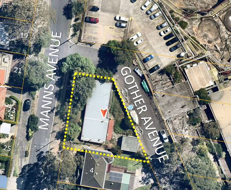
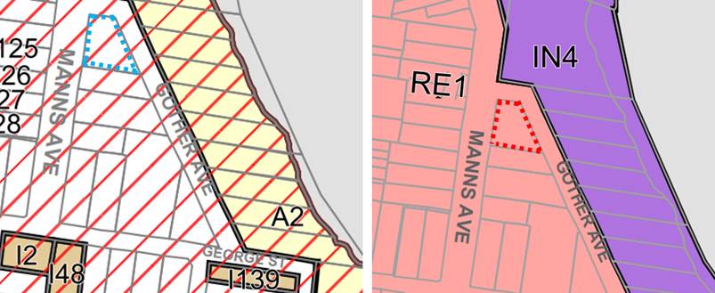
dwelling house and construction of a 2-storey dwelling with sub-level garage on land known as No. 2 Manns Avenue Greenwich.


General Conditions


That pursuant to Section 4.16(1)(a) of the Environmental Planning and Assessment Act 1979, the Council grants development consent to:

·          Development Application DA93/2023

·          Demolish existing dwelling and construct two-storey dwelling house

·          On 2 Manns Avenue Greenwich


subject to the following conditions:


PART A – GENERAL CONDITIONS


A.1 - Approved plans 

Development must be carried out in accordance with the following approved plans  (stamped by Council), except where the conditions of this consent expressly require otherwise.


Plan No

Revision

Plan Title

Drawn By

Dated

A00

M

3D Views

AGC Architects

18/02/24

A01

M

Compliance Table

AGC Architects

18/02/24

A05

M

Roof Plan / Site Plan / Site Analysis

AGC Architects

18/02/24

A06

M

Basement Plan

AGC Architects

18/02/24

A07

M

Ground Floor Plan

AGC Architects

18/02/24

A08

M

1st Floor Plan

AGC Architects

18/02/24

A09

M

Sections

AGC Architects

18/02/24

A10

M

East & North Elevations

AGC Architects

18/02/24

A11

M

South & West Elevations

AGC Architects

18/02/24

A12

M

Fence Elevations

AGC Architects

18/02/24


In the event of any inconsistency between the approved plans and a condition of this consent, the condition prevails.


Reason: To ensure all parties are aware of the approved plans and supporting documentation that applies to the development.


      A.2 - Design amendments and further information

Before the issue of a construction certificate, the certifier must ensure the approved construction certificate plans (and specifications) detail the following required amendments to the approved plans and supporting documentation stamped by Council.


1.   The 1st floor projecting non-trafficable slab is to be reduced to extend no greater than 500m beyond the external wall facing the front boundary.

2.   The southern perimeter of the ground floor balcony/BBQ area include 1.8m high solid privacy screen above finished floor level constructed with opaque materials.

3.   The existing garden stone walls are to be retained and protected during the demolition and construction phases and throughout the life of the development.

4.   An updated landscaping plan is to be submitted to align with the amended architectural plans.

5.   An updated Heritage Impact Statement (HIS) with expanded historical documentation of 2 Manns Avenue is to be submitted to Council prior to the issue of a Construction Certificate which details an archival record and full history post 1972 on the dwelling house and its occupants.


Reason: To require minor amendments to the approved plans and supporting documentation following assessment of the development.


A.3 - Payment of security deposits

Before the commencement of any works on the site, or the issue of a construction certificate, the applicant must make the following payment(s) to Council and provide written evidence of these payments to the Certifier:


Security deposit

Amount

Inspection Fee (2)

$420.00

Infrastructure damage bond

$4000.00

Council owned Trees

$5000.00


The payments will be used for the cost of:

·          making good any damage caused to any council property (including street trees) as a consequence of carrying out the works to which the consent relates,

·          completing any public work such as roadwork, kerbing and guttering, footway construction, stormwater drainage and environmental controls, required in connection with this consent, and

·          any inspection carried out by Council in connection with the completion of public work or the making good any damage to Council property.


Note: The inspection fee includes Council’s fees and charges and includes the Public Road and Footpath Infrastructure Inspection Fee (under the Roads Act 1993). The amount payable must be in accordance with council’s fees and charges at the payment date.


Note: Council inspection fees are calculated in accordance with Council’s fees and charges at the payment date.


Note: Required Council inspections for civil works involving Council assets are to be carried out prior to the pouring of any concrete (formwork) and on completion of the construction. An initial site meeting is to be conducted with council and the contractor prior to the commencement of any of the above works to allow for discussion of Council construction / set out requirements.


The following items are to be inspected:

·          proposed stormwater connection to existing Council pit (see condition A.10.E) in the street;

·          any adjustment works in Council’s Road reserve.

Reason: To ensure any damage to public infrastructure is rectified and public works can be completed.


A.4 - Payment of building and construction industry long service levy

Before the issue of a construction certificate, the applicant is to ensure that the person liable pays the long service levy of $5,620 as calculated at the date of this consent to the Long Service Corporation or Council under section 34 of the Building and Construction Industry Long Service Payments Act 1986 and provides proof of this payment to the principal certifier.

Reason: To ensure the long service levy is paid.


A.7.L - Tree preservation and approved landscaping works

The protection of trees in Lane Cove is regulated under the State Environmental Planning Policy (Biodiversity and Conservation) 2021 (SEPP) parts 2.2 and 2.3 which prohibits the clearing of vegetation without the authority conferred by a permit granted by Council. Clearing under the SEPP is defined as:


(a)  cut down, fell, uproot, kill, poison, ringbark, burn or otherwise destroy the vegetation, or

(b)  lop or otherwise remove a substantial part of the vegetation.


The clearing of trees or vegetation protected by the regulation is an offence against the Environmental Planning and Assessment Act 1979 (NSW).


The maximum penalty that may be imposed in respect to any such offence is $1,100,000 per individual and $5,500,000 per corporation.

The following trees shall be retained:


Tree No.

Species

Location

Dimension (m)

1

Eucalyptus scoparis

4 Manns Ave

24 x 20

2

Photinia robusta

4 Manns Ave

1 x 3

4

Callistemon viminalis

Front of property

8 x 5

5

Callistemon viminalis

Council verge, Manns Ave

10 x 10

6

Schefflera actinophylla

Council verge, Manns Ave

11 x 6

7

Glochideon ferdinandi

Council verge, Manns Ave

6 x 10

8

Glochideon ferdinandi

Council verge, Manns Ave

9 x 13

9

Callistemon viminalis

Council verge, Manns Ave

2 x 1

10

Banksia serrata

Council verge, Manns Ave

2 x 2

11

Banksia serrata

Council verge, Manns Ave

3 x 2

12 a and b

Callistemon viminalis

Council verge, Manns Ave

2 x 1

14

Callistemon viminalis

Council verge, Gother Ave

5 x 4

15

Callistemon viminalis

Council verge, Gother Ave

5 x 4

16

Callistemon viminalis

Council verge, Gother Ave

5 x 4

17

Callistemon viminalis

Council verge, Gother Ave

5 x 4


This consent gives approval for the removal of the following trees:


Tree No.

Species

Location

Dimension (m)

3

Senna pendula

Front boundary

6 x 5

18

Camellia sasanqua

Rear of property

5 x 5


This consent gives approval to carry out the following works in Tree Protection Zones:


Tree No.

Species

Location

Permitted works in TPZ

 2

Photinia robusta

 4 Manns Ave

Construction of boundary fence

4

Callistemon viminalis

Front of property

Construction of front pathway and fence

5

Callistemon viminalis

Council verge, Manns Ave

Construction of boundary fence

6

Schefflera actinophylla

Council verge, Manns Ave

Construction of boundary fence

7

Glochideon ferdinandi

Council verge, Manns Ave

Construction of boundary fence

8

Glochideon ferdinandi

Council verge, Manns Ave

Construction of boundary fence

14

Callistemon viminalis

Council verge, Gother Ave

Construction of boundary fence, Stormwater services

15

Callistemon viminalis

Council verge, Gother Ave

Construction of boundary fence, Stormwater services

16

Callistemon viminalis

Council verge, Gother Ave

Construction of boundary fence, Stormwater services

17

Callistemon viminalis

Council verge, Gother Ave

Construction of boundary fence, Stormwater services


Tree removal may only occur upon issue of a Construction Certificate.

Reason: To ensure the protection of trees to be retained and to confirm trees removed for pruning/removal.


A.9.T - Works on Council land

A separate application shall be made to Council’s Urban Services Division for any associated works on Council property. Written approval is to be obtained prior to the start of any works on Council property.

Reason: To manage impacts to Council’s assets.


A.10.E - Drainage plan amendments

Before the issue of a construction certificate, the certifier must ensure the approved construction certificate plans (and specifications) detail the following required amendments to the approved stormwater drainage plans prepared by ADC Design Group Pty Ltd, reference No: C233847, issue: A and dated in 12/06/23. This amended plan shall satisfy part O of the Council’s stormwater DCP.


·          The proposed kerb connection of stormwater is not permissible because of the inclusion of pump out system. Council requires to connect stormwater to existing pit in Gother Avenue. The location of existing Council’s stormwater pit and pipe system in Gother Avenue shall be located and shown in the plan.

·          Proposed drainage system should show pipe sizes and invert levels up to connection point; confirming pipe system satisfies part O of Council’ storm water DCP.

·          Clean out pits are required at all low points of charged drainage line if charged pipe system is proposed.

·          The stormwater requirements shown in Basix certificate shall be included in stormwater management plan and satisfied.

·          Sediment control fence shall be placed around the construction site and shown in plan

·          Subsoil seepage agg-line drainage is required around proposed retaining wall, dwelling, basement or as it is necessary and connected to proposed drainage system

·          This DA requires 10000 litre of rainwater tank. The applicant preferred to go for 10000 litre of rainwater tank which is acceptable. The detailed design for this proposed system is required.

·          A pollution control pit (as shown in section 3.4.1 in part O of Council’s stormwater DCP) with mesh (RH3030) and sump(300mm minimum) is required within the site, at start of the connection pipe to the Council pit. These details shall be shown in plan.

·          The stormwater runoff from driveway shall be collected by grated driveway pit and connected to pump out and/or stormwater system.

·          Driveway grated strip pit shall have minimum 200mm of depth and 1% fall inside.

·          Minimum of 1.8m height difference is required between start and end of the charged pipe system as per section 5.1 in Council DCP if charged system is used. The details of design level difference shall be shown in plan.

·          The connection pipe from site to pit shall be designed for gravity discharge only and no charged pipe line allowed.

·          Bends on discharge pipe from site to Council pit are not allowed.

·          Council will not support any pit where the flow direction changes more than 90 degree.

·          The proposed rainwater reuse system with a minimum effective capacity of 10,000 litres and to be installed in accordance with Section 7.3 in Council’s Stormwater DCP and relevant Australian standards. This tank shall have 100mm air gap on top and 100mm sludge zone at the bottom and installed satisfying Australian standards.

·          The entire roof area to be connected to Rainwater tank as per section 7.3 in Council DCP.

·          Only roof water shall be connected to rainwater tank.

·          The proposed pump out system for the basement is required and shall satisfy section 5.4 of Part O of Council’s stormwater DCP. The full details of the hydraulic calculation for pump out system shall be included in stormwater management plan and submitted to Council.

·          The proposed basement shall be constructed with water-proof walls around the basement.

·          Installation of the pipe system near the Council’s and protected trees must be assessed and approved by Council Tree Officer.

Certification from a suitably qualified engineer as to the matters below is to be provided to the Principal Certifying Authority, prior to the issue of any CC:


·          Compliance with the amendments detailed in this condition.

·          Compliance with Part O: Stormwater Management of Council’s DCP.

Where a variation is sought, written approval is to be obtained from Council’s Urban Services Division.

Reason: To ensure adequate stormwater management in accordance with Council’s DCP.


A.12 – Construction Certificate

The submission of a Construction Certificate and its issue by Council or Principal Certifier PRIOR TO CONSTRUCTION WORK commencing.

Reason: To ensures the detailed construction plans and specifications comply with the requirements of the Building Code of Australia (BCA) and any relevant Australian Standard.


PART B – PRIOR TO DEMOLITION WORKS


B.1.T - Demolition Traffic Management Plan

As a result of the site constraints, limited vehicle access and parking, a demolition traffic management plan (DTMP) and report shall be prepared by a Transport for NSW accredited person and submitted to and approved by Council prior to commencing any demolition work.

The DTMP must:-

·          Make provision for all construction materials to be stored on site, at all times.

·          Specify construction truck routes and truck rates. Nominated truck routes are to be distributed over the surrounding road network where possible.

·          Provide for the movement of trucks to and from the site, and deliveries to the site. Temporary truck standing/ queuing locations in a public roadway/ domain in the vicinity of the site is not permitted unless a Works Zone is approved by Council.

·          Include a Traffic Control Plan prepared by an RMS accredited ticket holder for any activities involving the management of vehicle and pedestrian traffic.

·          Specify that a minimum seven (7) days notification must be provided to adjoining property owners prior to the implementation of any temporary traffic control measures.

·          Include a site plan showing the location of any site sheds, location of requested Work Zones, anticipated use of cranes, structures proposed on the footpath areas (hoardings, scaffolding or temporary shoring) and extent of tree protection zones around Council Street trees.

·          Take into consideration the combined construction activities of other development in the surrounding area. To this end, the consultant preparing the DTMP must engage and consult with developers undertaking major development works within a 250m radius of the subject site to ensure that appropriate measures are in place to prevent the combined impact of construction activities. These communications must be documented and submitted to Council prior to work commencing on site.

Be prepared in accordance with relevant sections of Australian Standard 1742 – “Manual of Uniform Traffic Control Devices”, RMS’s Manual – “Traffic Control at Work Sites”.

Reason: To ensure public safety and minimise any impacts to the adjoining pedestrian and vehicular traffic systems.


B.2.E - Asbestos removal, handling and disposal

The removal, handling and disposal of asbestos from building sites shall be carried out in accordance with the requirements of the Occupational Health and Safety Act and the Regulations. Details of the method of removal in accordance with this condition is to be submitted to the Principal Certifier and Council’s Environmental Health Section, prior to commencing any demolition works.


Reason: To ensure worker and public health and safety.


B.3.EH - Compliance with demolition standard

Demolition of buildings and structures must comply with Australian Standard AS 2601—2001: The Demolition of Structures.

Reason: Prescribed condition under the EP&A Regulation 2021.


B.4.EH - Demolition work plan: The name, address, contact details and licence number of the Demolisher / Asbestos Removal Contractor.

·          Details of hazardous materials (including asbestos).

·          Method/s of demolition (including removal of any asbestos).

·          Measures and processes to be implemented to ensure the health & safety of workers and community.

·          Measures to be implemented to minimise any airborne dust and asbestos.

·          Methods and location of disposal of any hazardous materials (including asbestos).

·          Other relevant details, measures and requirements to be implemented.

·          Details of re-use, recycling and disposal of waste materials.

·          Date the demolition works will commence.

Reason: To ensure health and safety.


            B.13.L - Project Arborist

Prior to the commencement of any works, including demolition, a Project Arborist of minimum Australian qualitative framework (AQF) Level 5 qualification, is to be appointed to oversee/monitor trees/condition compliance during the construction process. A letter of engagement must be provided to Council prior to issue of a construction certificate. Compliance certificates must be available upon request, submitted to the Principal Certifier within five days of site attendance and must be available to council immediately upon request prior to the issue of an occupation certificate; failure to produce the latest certificate will be considered a breach of conditions.  Each compliance certificate must contain photographic evidence to confirm site attendance. A compliance certificate is required for each of the following phases.


The project Arborist shall:

·          Certify all tree protection measures listed prior to demolition works

·          Clearly identify which are to be removed and which trees are to be retained as part of this consent

·          Oversee the excavation of the boundary fence piers and footings

·          Oversee the excavation and installation of stormwater services within the TPZ of protected trees

·          Oversee the excavation and construction of the front pathway

·          Provide quarterly health and condition assessments on protected trees

·          Statement upon completion for the development that all retained trees have been

·          maintained in a healthy, viable condition and replacement planting has been undertaken. The statement must also recommend remedial advice for trees post construction to mitigate and long-term construction impacts.

Reason: To ensure trees are protected and retained on the site.


B.14 Special Condition - Tree Protection Measures Fencing


The following tree protection measures must be in place prior to demolition works and certified by the project arborist.


Tree Protection Fencing must be installed within the following locations:


1.   Along the area marked within the tree protection plan on page 22 of the supplied Arborist report by McArdle Consultancy dated 15/05/23.

2.   Encompassing trees 14 – 17 on the Council verge bordering Gother Avenue.


The fencing must consist of a 1.8 m high chain mesh fence held in place with concrete block footings and fastened together. An example of fencing is shown under figure 3 on page 16 of the Australian Standard 4970-2009 The Protection of Trees on Development. The fenced area shall not be used for the storage of building materials, machinery, site sheds, or for advertising and the soil levels within the fenced area shall remain undisturbed.


A waterproof sign must be placed on every second panel stating, ‘NO ENTRY TREE PROTECTION AREA – this fence and sign are not to be removed or relocated for the work duration.’  Minimum size of the sign is to be A3 portrait with NO ENTRY TREE PROTECTION ZONE in capital Arial Font size 100, and the rest of the text in Arial font size 65.


Such fencing and signage must be erected Prior to Demolition including site preparation and remain in place for the duration of the construction work.


Movement of Tree Protection Fencing must be overseen and approved by the project Arborist with notification provided to Council’s Tree Management Officer in writing.

           Reason:  To protect the natural environment


PART C - BEFORE THE ISSUE OF A CONSTRUCTION CERTIFICATE


C.1 - Construction site management plan

Prior to any demolition works and before the issue of a construction certificate, the applicant must ensure a construction site management plan is provided to and approved by the principal certifier. The plan must include the following matters:


·          location and materials for protective fencing and hoardings to the perimeter on the site.

·          For sites adjoining bushland a 1.8m chain mesh perimeter fence with 1m sediment fencing attached to the lower portion is required to ensure that no foreign materials enter the bushland.

·          provisions for public safety

·          pedestrian and vehicular site access points and construction activity zones

·          details of construction traffic management, including proposed truck movements to and from the site and estimated frequency of those movements, and measures to

·          preserve pedestrian safety in the vicinity of the site. The construction traffic management plan shall comply with the requirements of Part R of Lane Cove DCP 2010 and shall be submitted to Council’s Traffic Section for written approval. Consultation with NSW Police, TfNSW, and Sydney Buses may be required. Note: Heavy vehicles are not permitted to travel on local roads without Council approval.

·          protective measures for on-site tree preservation (including in accordance with AS 4970-2009 Protection of trees on development sites and Council’s DCP, if applicable) and trees in adjoining public domain (if applicable)

·          For major works, appointment of a project arborist of minimum AQF Level 5 qualification to oversee/monitor tree(s) condition during the construction process.

·          details of any bulk earthworks to be carried out

·          location of site storage areas and sheds

·          equipment used to carry out all works

·          a garbage container with a tight-fitting lid

·          dust, noise and vibration control measures including a construction noise management plan prepared in accordance with the NSW EPA’s Interim Construction Noise Management Guidelines by an appropriately qualified acoustic consultant.

·          location of temporary toilets.


The applicant must ensure a copy of the approved construction site management plan is kept on-site at all times during construction.


Council Approvals

·          Where hoarding is required to be provided along the street frontage, a Hoarding Application is to be submitted to Council for approval.

·          Any construction plant on the public road reservation requires an approved “Application for standing plant permit”.


Additional Council Requirements

·          Stockpiles or soil shall not be located on / near any drainage lines or easements, natural watercourses or water bodies, footpath or roadway without first providing suitable protective measures adequate to protect these water bodies.

·          All stockpiles of contaminated materials must be stored in an environmentally sensitive manner in a secure area on the site and shall be suitably covered to prevent dust and odour nuisance.

·          All stockpiles of potentially contaminated soil must be assessed in accordance with relevant NSW Environment Protection Authority guidelines, including NSW EPA Waste Classification Guidelines (2014).

·          Where sites adjoin bushland:

·          For sites identified to be within bushfire prone land An Asset Protection Zone (APZ) shall be provided entirely within the site boundary. To protect bushland and property from fire risk, APZ standards are to be in accordance with Planning for Bushfire Protection (PBP) 2019.

·          Access to the site from adjacent parks/reserves/bushland for the purposes of carrying out building works, landscaping works,  storage materials, storage of soil or rubbish is not permitted.

Reason: To require details of measures that will protect the public, and the  surrounding environment, during site works and construction.


C.2 - Erosion and sediment control plan

Prior to any demolition works or clearing of any vegetation and before the issue of a construction certificate, the applicant is to ensure that an erosion and sediment control plan is prepared in accordance with the following documents before it is provided to and approved by the principal certifier:


·          Council’s development control plan,

·          the guidelines set out in the NSW Department of Housing manual ‘Managing Urban Stormwater: Soils and Construction Certificate’ (the Blue Book), and

·          the ‘Do it Right On-Site, Soil and Water Management for the Construction Industry' (Southern Sydney Regional Organisation of Councils and the Natural Heritage Trust).

The applicant must ensure the erosion and sediment control plan is kept on- site at all times during site works and construction.


Reason: To ensure no substance other than rainwater enters the stormwater system              and waterways


C.4 - Utilities and services

Before the issue of the relevant construction certificate, the applicant must submit the following written evidence of service provider requirements to the certifier:

·          a letter of consent from the electricity supplier <Insert Electricity Supply Authority>  demonstrating that satisfactory arrangements can be made for the installation and supply of electricity.

·          a response from Water NSW as to whether the plans proposed to accompany the application for a construction certificate would affect any Water NSW infrastructure, and whether further requirements need to be met.

·          other relevant utilities or services - that the development as proposed to be carried out is satisfactory to those other service providers, or if it is not, what changes are required to make the development satisfactory to them.

Reason: To ensure relevant utility and service providers requirements are provided to the certifier.


C.23.B - Sydney Water requirements

The approved plans must be submitted to Sydney Water online approval portal “Sydney Water Tap In” for approval.

Reason: To comply Sydney Water requirements.


C.24.E - Structural engineer’s details

The Construction Certificate plans and specifications must include detailed professional structural engineering plans and/or specifications for the following:

·          underpinning;

·          retaining walls;

·          footings;

·          reinforced concrete work;

·          structural steelwork;

·          upper-level floor framing;

and where relevant in accordance with any recommendations contained in an approved geotechnical report.

Reason: To ensure structural adequacy.


PART D - BEFORE THE COMMENCEMENT OF BUILDING WORK


D.1 - Erosion and sediment controls in place

Before the commencement of any site or building work, the principal certifier must be satisfied the erosion and sediment controls in the erosion and sediment control plan, (as approved by the principal certifier) are in place until the site is rectified (at least 70% ground cover is achieved over any bare ground on site).

Reason: To ensure runoff and site debris do not impact local stormwater systems and waterways.


D.3 - Signs on site

A sign must be erected in a prominent position on any site on which building work or demolition work is being carried out:

·          showing the name, address and telephone number of the principal certifier for the work; and

·          showing the name of the principal contractor (if any) for any building work and a telephone number on which that person may be contacted outside working hours; and

·          stating that unauthorised entry to the work site is prohibited.

Any such sign is to be maintained while any demolition or building work is being carried out but must be removed when these works have been completed.


Note: This does not apply in relation to building work, or demolition work, that is carried out inside an existing building that does not affect the external walls of the building.

Reason: Prescribed condition under section 70 of the EP&A Regulation 2021.


           D.4 - Compliance with the Home Building Act

In the case of residential building work for which the Home Building Act 1989 requires there to be a contract of insurance in force in accordance with Part 6 of that Act, that such a contract of insurance is in force before any building work authorised to be carried out by the consent commences.

Reason: Prescribed condition under section 69 of the EP&A Regulation 2021.


D.5 - Home Building Act requirements

Residential building work within the meaning of the Home Building Act 1989 must not be carried out unless the principal certifier for the development to which the work relates (not being Council) has given Council written notice of the following information —

·          In the case of work for which a principal contractor is required to be appointed -

·          the name and licence number of the principal contractor, and

·          the name of the insurer by which the work is insured under Part 6 of that Act,

·          In the case of work to be done by an owner-builder—

·          the name of the owner-builder, and

·          if the owner-builder is required to hold an owner-builder permit under that Act, the number of the owner-builder permit.

If arrangements for doing the residential building work are changed while the work is in progress so that the information notified becomes out of date, further work must not be carried out unless the principal certifier for the development to which the work relates (not being the Council) has given Council written notice of the updated information.

Reason: Prescribed condition under section 71 EP&A Regulation 2021.


PART E - WHILE BUILDING WORK IS BEING CARRIED OUT


E.1 - Hours of work

The principal certifier must ensure that building work, demolition or vegetation removal is only carried out between:

Monday to Friday (inclusive)                    7.00am to 5.30pm

Saturday                                                   7.00am to 4.00pm

With NO high noise generating activities, to be undertaken after 12 Noon on Saturday.


A Notice/Sign showing permitted working hours and types of work permitted during those hours, including the applicant’s phone number, project manager or site foreman, shall be displayed at the front of the site.


The principal certifier must ensure building work, demolition or vegetation removal is not carried out on Sundays and public holidays, except where there is an emergency.

Reason: To protect the amenity of the surrounding area.


E.2 - Compliance with the Building Code of Australia

Building work must be carried out in accordance with the requirements of the Building Code of Australia.

Reason: Prescribed condition under section 69 of the EP&A 2021.


E.4 - Implementation of the site management plans

While vegetation removal, demolition and/or building work is being carried out, the applicant must ensure the measures required by the approved construction site management plan and the erosion and sediment control plan are implemented at all times.


The applicant must ensure a copy of these approved plans is kept on site at all times and made available to Council officers upon request.

Reason: To ensure the required site management measures are implemented during construction.


E.5 - Implementation of BASIX commitments

While building work is being carried out, the applicant must undertake the development strictly in accordance with the commitments listed in the BASIX certificate submitted under this application.

Reason: To ensure BASIX commitments are fulfilled in accordance with the BASIX certificate (prescribed condition under section 75 of the EP&A Regulation 2021.


E.6 - Surveys by a registered surveyor

While building work is being carried out, a registered surveyor is to measure and mark the positions of the following and provide them to the principal certifier —

·          All footings/ foundations

·          At other stages of construction – any marks that are required by the principal certifier.

Reason: To ensure buildings are sited and positioned in the approved location


E.7 - Construction noise

While building work is being carried out where no noise and vibration management plan is approved under this consent, the applicant is to ensure that any noise caused by demolition, vegetation removal or works does not exceed an LAeq (15 min) of 5dB(A) above background noise, when measured at any lot boundary of the property where these works are being carried out.

Reason:  To protect the amenity of the neighbourhood.


E.8 - Tree protection

While site or building work is being carried out, the applicant must maintain all required tree protection measures in good condition in accordance with the construction site management plan required under this consent, the relevant requirements of AS 4970-2009 Protection Of Trees on Development Sites and any Arborist’s report approved under this consent and Part B. This includes maintaining adequate soil grades and ensuring all machinery, builder’s refuse, spoil and materials remain outside tree protection zones.

Reason: To protect trees during construction.


E.9 - Responsibility for changes to public infrastructure

While building work is being carried out, the applicant must pay any costs incurred as a result of the approved removal, relocation or reconstruction of infrastructure (including ramps, footpaths, kerb and gutter, light poles, kerb inlet pits, service provider pits, street trees or any other infrastructure in the street footpath area).

Reason: To ensure the payment of approved changes to public infrastructure.


E.15.B - Critical stage inspections

Critical stage inspections are to be carried out in accordance with Section 6.5 of the EP&A Act 1979 and sections 61, 63 and 65 of the Environmental Planning and Assessment (Development Certification and Fire safety) Regulation 2021.


Where Lane Cove Council is appointed as the principal certifier, an inspection is to be booked for each of the following relevant stages during the construction process:

·          underpinning;

·          retaining walls;

·          footings;

·          reinforced concrete work;

·          structural steelwork;

·          upper level floor and roof framing; and

Reason: EP&A Act requirement.


E.18.B - No obstruction of public way

The public way and Council verge must not be obstructed by any materials, vehicles, refuse, skips or the like, under any circumstances. Non-compliance with this requirement will result in the issue of a notice by Council to stop all work on site.

Reason: To ensure public safety.


E.19.B – Encroachments

·          No portion of the proposed structure shall encroach onto adjoining properties.

·          The proposed construction shall not encroach onto any existing Council drainage pipe or easement unless approved by Council. If a Council stormwater pipe is located at site during construction, Council is to be immediately notified. Where necessary the drainage line is to be reconstructed or relocated to be clear of the proposed building works. Developer must lodge Stormwater Inspection Application form to Council. All costs associated with the reconstruction or relocation of the drainage pipe are to be borne by the applicant. Applicant is not permitted to carry out any works on existing Council and private stormwater pipe lines without Council’s approval.

Reason: To ensure works are contained wholly within the subject site


E.20.EH – Stockpiles

Stockpiles of topsoil, sand, aggregate, spoil or other material capable of being moved by water to be stored clear of any drainage line, easement, natural watercourse, footpath, kerb or roadside.

Reason: To mitigate adverse environmental impacts on the surrounding area.


E.25 - Special Condition - Construction of boundary fence, excavation of piers

The new boundary fence along a Gother Avenue and Manns Avenue must be constructed from lightweight materials using the pier and beam method.


Excavation required for pier / post holes within the TPZ and SRZ of retained trees must be undertaken using hand tools only and overseen by the project arborist. Pier locations must be flexible, with a 150mm buffer granted to roots greater than 40mm diameter. Roots less than 40mm diameter that conflict with pier locations may be cleanly severed with a sharp implement and documented by the project arborist within a compliance certificate. Pier / post holes within a TPZ or SRZ that require concrete footings must be lined with a heavy-duty polyethylene film (builders Plastic) prior to pouring to prevent leaching. Exposed roots must be protected in accordance with section 4.5.4 of AS4970/2009 The Protection of Trees on Development sites.

Reason: To minimise damage to protected trees.


E.26 - Special condition – Stockpiling of Materials

No stockpiling of materials, building equipment or additional activities listed in section 4.2 of AS4970-2009 The Protection of trees on Development Sites is to occur within designated tree protection areas or on the Council Owned Nature Strip. All building materials must be stored within the subject site.

Reason: To mitigate damage to Council land.


E.27 - Special Condition – Construction of the entrance pathway

The new pathway within the Tree Protection Zone of tree #4 is to be constructed on or above grade. Permeable fill consisting of 20mm angular stone is to be required to level any undulating ground. A geotextile fabric should then be used to separate the fill from a sand bedding layer. Permeable paving may then be placed on the layer of sand bedding. Level depths of subbase are to be determined by the landscape company. Pathway is to be overseen by the project arborist, roots >40mm diameter are to be damaged during installation of the pathway. Roots <40mm diameter than conflict with the pathway must be documented by the project arborist and cleanly severed using a sharp implement. Exposed roots must be protected in accordance with section 4.5.4 of AS4970/2009 The Protection of Trees on Development sites.

Reason: To minimise damage to protected trees.


E.28 - Special Condition – Excavation for stormwater services

Excavation and installation of stormwater services within the TPZ of protected trees must be overseen by the project arborist. Excavation is to be undertaken using non-destructive methods (Hand tools, Hydrovac, Directional Drilling). No roots greater than 40mm diameter are to be damaged / severed as part of works. Roots less than 40mm diameter than conflict with services must be documented by the project arborist within a compliance certificate and pruned using a sharp implement. Service location must be flexible, with a 150mm diameter buffer allowed to roots greater than 40mm diameter to allowed for future growth. Exposed roots must be treated and protected in accordance with provisions outlined within section 4.5.4 of AS4970-2009 The protection of trees on Development Sites.

Reason: To minimise damage to the root system of protected trees


PART F - BEFORE THE ISSUE OF AN OCCUPATION CERTIFICATE


F.1 - Works-as-executed plans and any other documentary evidence

Before the issue of the relevant occupation certificate, the applicant must submit, to the satisfaction of the principal certifier, works-as-executed plans, any compliance certificates and any other evidence confirming the following completed works:

·          All stormwater drainage systems and storage systems

·          The following matters that Council requires to be documented:

·          Compliance with Part O - Stormwater Management of Lane Cove DCP 2010. Where a variation is sought, written approval shall be obtained from Council’s Urban Services Division.

·          Compliance with the requirements for waste and recycling, and bulky waste storage room(s) set out in Part Q – Waste Management and Minimisation of Lane Cove DCP 2010. 

·          Compliance with AS-3500.

·          Certification from a suitably qualified engineer that the approved stormwater pipe system and on-site stormwater detention (OSD) system has been constructed in accordance with the approved plans.

·          Where relevant, registration of any positive covenants over the OSD system and basement pump out system.

·          Signed plans by a registered surveyor clearly showing the surveyor’s details and date of signature.

·          Evidence of removal of all redundant gutter and footpath crossings and reinstatement of all kerb, gutter and footpaths to the satisfaction of Council’s Urban Services Division.


The principal certifier must provide a copy of the plans to Council with the occupation certificate.

Reason: To confirm the location of works once constructed that will become Council assets.


F.2 - Completion of public utility services

Before the issue of the relevant occupation certificate, the principal certifier must ensure any adjustment or augmentation of any public utility services including gas, water, sewer, electricity, street lighting and telecommunications, required as a result of the development, is completed to the satisfaction of the relevant authority.


Before the issue of the occupation certificate, the principal certifier must request written confirmation from the relevant authority that the relevant services have been completed.

Reason: To ensure required changes to public utility services are completed, in accordance with the relevant agency requirements before occupation.


F.4 - Preservation of survey marks

Before the issue of an occupation certificate, a registered surveyor must submit documentation to the principal certifier which demonstrates that:

·          no existing survey mark(s) have been removed, damaged, destroyed, obliterated or defaced, or

·          the applicant has re-established any survey mark(s) that were damaged, destroyed, obliterated or defaced in accordance with the Surveyor General’s Direction No. 11 – Preservation of Survey Infrastructure.

Reason: To protect the State’s survey infrastructure.


F.5 - Repair of infrastructure

Before the issue of an occupation certificate, the applicant must ensure any public infrastructure damaged as a result of the carrying out of building works (including damage caused by, but not limited to, delivery vehicles, waste collection, contractors, sub-contractors, concreting vehicles) is fully repaired to the written satisfaction of Council, and at no cost to Council.


Note: If the council is not satisfied, the whole or part of the security/bond submitted will be used to cover the rectification work.

Reason: To ensure any damage to public infrastructure is rectified.


F.6 - Removal of waste upon completion

Before the issue of an occupation certificate, the principal certifier must ensure all refuse, spoil and material unsuitable for use on the site is removed from the site and disposed of in accordance with the waste management plan. Written evidence of the removal must be supplied to the satisfaction of the principal certifier.

Before the issue of a partial occupation certificate, the applicant must ensure the temporary storage of any waste is carried out in accordance with the approved waste management plan to the principal certifier’s satisfaction.

Reason: To ensure waste material is appropriately disposed of or satisfactorily stored.


F.7 Tree Replacement

Trees that are removed must be replaced on a 1:1 ratio to comply with provisions outlined within Part J Landscaping of the Lane Cove Council Development Control Plan 2010.


Replacement planting is to be done in accordance with landscape plan L01 by Michael Siu dated 18th May 2023.


Tree selected must be from a registered nursery and comply with provisions outlined within AS2303:2018 Tree Stock for Landscape Use.


All landscaped areas must have an automatic irrigation system on a timer that provides adequate water for the ongoing health and vitality of the plants.


Trees must be installed and signed off by the project arborist Prior to the issue of an Occupation Certificate.

Reason: Council replacement policy.


PART H - OCCUPATION AND ONGOING USE


H.1 - Release of securities / bonds

When Council receives an occupation certificate from the principal certifier, the applicant may lodge an application to release the securities held in accordance with Condition A.3. Council may use part, or all of the securities held to complete the works to its satisfaction if the works do not meet Council’s requirements.

Reason: To allow release of securities and authorise Council to use the security deposit to complete works to its satisfaction.


Mark Brisby

Director - Planning and Sustainability

Planning and Sustainability Division


ATTACHMENTS:

There are no supporting documents for this report.


Lane Cove Local Planning Panel Meeting 27 March 2024

266 Longueville Road, Lane Cove - s4.55 Modification of Consent


Subject:          266 Longueville Road, Lane Cove - s4.55 Modification of Consent    

Record No:    DA17/117-01 - 14948/24

Division:         Planning and Sustainability Division

Author(s):       Robert Montgomery 


Property:

Lot 1 in DP 321353, Lot 1 in DP 1227921 and Lot 2 in DP 1227921 (No. 266) Longueville Road Lane Cove

DA No:

DA 117/2017

Date Lodged:

11 January 2024

Cost of Work:

$81,345,000.00 

Owner:

Lane Cove Council

Applicant:

The Trustee for Longueville The Village Unit Trust


Description of the proposal to appear on determination

Modification pursuant to s4.55(1A) of Development Consent DA117/2017 and approved plans to reflect changes to parking,  vehicle ramp entry, internal layouts, courtyards, setbacks, and external finishes/design elements.

Zone

R4 High Density Residential

Is the proposal permissible within the zone

Yes

Is the property a heritage item

No

Is the property within a conservation area

No

Does the property adjoin bushland

Yes

BCA Classification

Class 2

Stop the Clock used

No

Notification

Neighbours: Notified from 11 January 2024 to 9 February 2024, with an extension granted to adjoining owner until end of February.


All submissions have been provided to the Panel.


SITE

Property

Lot 1 in DP 321353, Lot 1 in DP 1227921 and Lot 2 in DP 1227921

Area

9,204m2

Site location

266 Longueville Road Lane Cove

Existing improvements

None.  Demolition has occurred and groundworks commenced in accordance with development consent.

Shape

Irregular

Dimensions

Width 91m-103m                                                     Depth    84m-147m                      

Adjoining properties

East – Lane Cove Golf Course                      West – Longueville Road, Buddhist Temple and detached dwellings

North – Residential flat building and detached dwellings

South – Residential flat building known as “timbertops”


SITE APPLICATION HISTORY

DA 117/2017

Construction of a seniors housing development comprising 70bed residential aged care facility, 82 independent living units/selfcontained


dwellings, with basement car parking for 122 vehicles, new public park and facilities and landscaped throughsite link.  Approved by SNPP 6/9/21


S4.55(1) Mod

Minor modification to enable multiple construction certificates to be issued under the consent for various stages of work.  Approved LCLPP 6/12/22

S4.55(2) Mod

Change in accommodation mix to solely independent living units, provision of additional basement level for car parking and services, removal of commercial tenancy and a number of adjustments to building envelope and external finishes.  Approved SNPP 28/7/23


PROPOSAL

The proposal is for a number of minor modifications to the consent and approved plans for construction of a seniors housing development, which was approved by Sydney North Planning Panel on 6 September 2021.  In summary, the proposed changes relate to parking, vehicle ramp entry, internal layouts, courtyards, setbacks, and external finishes/design elements.


The applicant states that “the proposed modifications will greatly increase the amenity for future residents of the development. Privacy to private open spaces will be improved, as well as increase in privacy for surrounding residents including those to the south in the ‘Timbertop’s’ development. There will also be improved pedestrian and traffic safety around the vehicular access point to the development. Some utility and site service improvements are proposed as advised by relevant consultants; for example, the increase in size/relocation of waste rooms, pump stations, tank rooms.”


The application is made pursuant to Section 4.55(1A) of the Environmental Planning and Assessment Act, 1979.


REASON FOR REFERRAL

The Sydney North Planning Panel previously delegated all functions relating to determination of applications to modify consent to Council’s General Manager.  However, as the Council is the owner of the land, the application is referred to the Lane Cove Local Planning Panel for determination in accordance with the relevant guidelines.


EXECUTIVE SUMMARY

This assessment report is prepared by Robert Montgomery, an independent town planner engaged by the Council to assess the application.


The Section 4.55(1A) application seeks to modify Development Consent DA117/2017 by proposing a number of changes relating to parking, vehicle ramp entry, internal layouts, courtyards, setbacks, and external finishes/design elements.


Approved by the Sydney North Planning Panel on 6 September 2021, the development is described as:

Construction of a seniors housing development comprising 70 bed residential aged care facility, 82 independent living units/self-contained dwellings, with basement car parking for 122 vehicles, new public park and facilities and landscaped through-site link.”


The development consent has been modified on two previous occasions as detailed in the site application history above.  The modification approved by the Sydney North Planning Panel on 28 July 2023 changed the description of the development to:

1.       “Construction of a seniors housing development comprising 92 independent living units/self-contained dwellings, with basement car parking, new public park and facilities and landscaped through site link.”


In accordance with the Lane Cove Community Participation Plan, the application was notified from 11 January to 9 February 2024.  An extension was granted granted to the owners of the adjoining “Timbertops” building until the end of February.  28 submissions were received.


The modification application has been assessed under the provisions of Sections 4.15 and 4.55 of the Environmental Planning and Assessment Act, 1979, and is recommended for approval.


SITE & SURROUNDINGS

The site comprises three parcels of land described as Lot 1 in DP 321353, Lot 1 in DP 1227921 and Lot 2 in DP 1227921, with a total area of 9,204m2.  The site is irregular in shape and has a northern boundary of approximately 147m, an eastern frontage to Lane Cove Golf Course of approximately 81m, a southern boundary of approximately 83m and a combined western frontage to Longueville Road of approximately 103m.


The site has a fall from north to south fall 0.85m along Longueville Road, and a fall from west to east of approximately 18m, from 57.83 AHD near the north-western end of the street frontage to 40.00 AHD near the eastern most edge of the development area. Beyond the eastern edge of the development site, there is a further fall to the east of approximately 10-11m to the Lane Cove golf course.


Figure 1: Satellite Image. Source: NSW LPI SIX Maps

A circuit board

Description generated with high confidence

Development in the surrounding area comprises a mix of single and two storey free standing dwelling houses, multi storey residential flat buildings, a Buddhist temple and recreational facilities


To the north is a residential flat building at Nos. 250-252 Longueville Road and detached dwelling houses at Nos. 42-58 Richardson Street.  To the east is dense bushland on steep topography that leads down towards the Lane Cove Golf Course.


To the south is a part three and part four storey residential flat building known as ‘Timbertops’. This building relies on a long-standing informal arrangement with the Council for the use of the driveway within the subject land for vehicular access to Longueville Road.  Figure 2 below illustrates this relationship.


Figure 2: Relationship to “Timbertops Building to South.

Development on the western side of Longueville Road comprises the former Masonic Lodge (now Buddhist Temple) and detached dwellings.


PREVIOUS APPROVALS/HISTORY

DA 117/2017

Construction of a seniors housing development comprising 70bed residential aged care facility, 82 independent living units/selfcontained dwellings, with basement car parking for 122 vehicles, new public park and facilities and landscaped throughsite link.  Approved by SNPP 6/9/21.


S4.55(1) Mod

Minor modification to enable multiple construction certificates to be issued under the consent for various stages of work.  Approved LCLPP 6/12/22.


S4.55(2) Mod

Change in accommodation mix to solely independent living units, provision of additional basement level for car parking and services, removal of commercial tenancy and a number of adjustments to building envelope and external finishes.  Approved SNPP 2/8/23.


Since development consent was issued, the site has been secured by construction fencing and demolition and ground works have commenced.


Attachment 1 is a copy of the development consent as amended.


PROPOSED MODIFICATION

The key modifications sought under this application include:

•     Addition of tandem parking at basement levels within approved basement envelope.

•     Additional accessible parking in accordance with State Environmental Planning Policy (Housing for Seniors or People with a Disability) 2004.

•     Alterations and layout changes to amenity areas and facilities to improve usability, amenity, and accessibility, including pool area, hair and nail salon, gym, residents’ workshop, meeting rooms and office spaces, and cinema.

•     Improvements to service and utilities, including increase to bulky waste room and configuration of layout of grease arrestor and second waste room.

•     Widening the ramp opening to car park with addition of island for safer movements and traffic flow.

•     Amendment to apartment layouts for better usability and amenity.

•     Additional courtyard and rooftop garden landscaping details.

•     Minor increase to setbacks on the east, with minor reduction to setbacks on the north.

•     Improved façade materiality and design to be more consistent with that of the Lane Cove neighbourhood character.

•   Amendment to balustrade details to provide improved privacy for neighbouring properties by including concrete upstands with infill glass.

Attachment 2 is a table prepared by the applicant which describes the proposed modifications compared with original consent and the approved modification.  Attachment 3, also provided by the applicant, contains detailed comparison statistics for the modification.


SECTION 4.55 ASSESSMENT

The application is made under section 4.55(1A) of the Environmental Planning and Assessment Act, 1979.  This section relates to “modifications involving minimal environmental impact” and provides that the consent authority may modify the consent if:


(a)     it is satisfied that the proposed modification is of minimal environmental impact, and

(b)     it is satisfied that the development to which the consent as modified relates is substantially the same development as the development for which the consent was originally granted and before that consent as originally granted was modified (if at all), and

(c)     it has notified the application in accordance with—

(i)    the regulations, if the regulations so require, or

(ii)   a development control plan, if the consent authority is a council that has made a development control plan that requires the notification or advertising of applications for modification of a development consent, and

(d)     it has considered any submissions made concerning the proposed modification within any period prescribed by the regulations or provided by the development control plan, as the case may be.

In relation to section 4.55(1A) (a), it is considered that the changes proposed by the modification are of minimal environmental impact only.  The proposed changes are mostly internal and no substantive changes are proposed.


In relation to section 4.55(1A) (b), the test is whether the development as proposed to be modified is substantially the same development as the development for which consent was originally granted.  There is a significant amount of case law relating to this test.  The relevant citations are provided below in a brief outline of the principles.


(a)      The comparison to be undertaken is between the proposed development as modified and the original approved development.

(b)     The question of whether a development is substantially the same as that which was originally approved is a question of fact and degree depending on the specific circumstances of each matter which will reasonably admit different conclusions: Scrap Realty Pty Limited v Botany Bay City Council (2008) 166 LGERA 342 at [13].

(c)     The meaning of "substantially the same" is "essentially or materially having the same essence": Vacik Pty Limited v Penrith City Council [1992] NSWLEC 8, Stein J; supported by Mason P in North Sydney Council v Michael Standley & Assoc Pty Ltd (1998) 43 NSWLR 468; 97 LGERA at 440.

(d)     The question of whether the development is substantially the same is not a question which is capable of scientific or mathematical precision, but rather is a judgment based on an overall quantitative and qualitative assessment: Moto Projects No. 2 Pty Limited v North Sydney Council (1999) 106 LGERA 298 Bignold J at [56]. This means that it must be a comparison not only of the physical changes, but an appreciation of the qualitative impacts of the development as approved.

(e)     However, the exercise is to be considered in the context of a statutory modification power that has been held to be "beneficial" and "facultative": Houlton v Woollahra MC (1997) 95 LGERA 201; Michael Standley & Assoc. Pty Ltd (supra) at 482; and "free standing": Michael Standley & Assoc. Pty Ltd (supra) at 481.

(f)      It is axiomatic that modifications to a development will result in some change. The term "modify" means "to alter without radical transformation". However, that does not mean that even quite extensive changes will result in the overall development becoming something other than substantially the same. In Michael Standley & Assoc. Pty Ltd the scope of the architectural change was significant, but not so as to radically alter the fundamental essence of the development.


The “substantially the same” test was considered at length by the Sydney North Planning Panel (SNPP) in its decision of 28 July 2023 to modify the consent by, inter alia, removing the 70-bed residential aged care facility from the development.  Notwithstanding, the current modification application must satisfy the test.  That is, is the development as proposed to be modified substantially the same development as the development for which consent was originally granted?


The applicant provides the following information to assist the Panel in considering the matter:


Substantially the same test - Consent

 A Section 4.55(1A) Modification Application can only be applied where an existing active Development Consent exists.  As noted previously, Development Consent DA117/2017 which granted approval for the “Construction of a seniors housing development comprising 70bed residential aged care facility, 82 independent living units/self contained dwellings, with basement car parking for 122 vehicles, new public park and facilities and landscaped throughsite link” applies to the site has not lapsed for the purposes of the EP&A Act.


Substantially the same test – Land Use

Development Consent DA117/2017 is primarily a consent for a ‘seniors housing’ land use as per the former State Environmental Planning Policy (Housing for Seniors or People with a Disability) 2004, this aspect of the approved development will not change in terms of how the development is viewed or interpreted in terms of the built form and operation of the premises.


Affordable housing places pursuant to Clause 45(6) of SEPP HSPD are maintained. In this regard the operator will make this housing available through an Affordable Housing Policy which provides:


•      On-site support services to enable residents to ‘age in place’ for the entire facility including three meals a day provided on a communal basis or to a resident’s dwelling, personal care, home nursing visits, assistance with housework and laundry as required, and

•      10 Units (10.8%) of the inventory to be eligible for affordable housing.


The Original Consent approved 82 ILUs as seniors housing in a residential flat development form. The previous modification received consent to change the housing mix to 92 ILUs and removed the provision of residential aged care beds. These ILUs are maintained in this modification, subject to internal layout changes proposed which allow for more usable spaces by residents.


Residential amenity and commercial components are proposed in same built form, and the modifications merely reflect minor change to the scale of activities, transactions or processes that are already approved, rather than the introduction of any activities, transactions or processes which differ in kind from the originally approved use. It is noted that the minor layout changes and slight relocation of some residential amenity spaces are proposed to create improved spaces that are more accessible and will not affect the privacy of any ILUs.


Activity spaces and outdoor recreation areas will be maintained, the provision of more specified activities is minor change to the scale of activities, transactions or processes that are already approved, rather than the introduction of any activities, transactions or processes which differ in kind from the originally approved use.


Provision of the landscaped throughsite link is maintained.

Provision of the public park and facilities are maintained.


Substantially the same test – Built Form

The development maintains the approved bulk and scale of the development which will cause no significant changes to the streetscape or relationship to neighbouring properties. Minor amendments are proposed to increase setbacks to the east and reduce setbacks to the north. Minor amendments are proposed to increase lift overruns on each building. This is minimal in nature and does not overall contribute to any potential of the built form being considered as materially different. The location of the lift overruns toward the centre of each building will ensure no impact is caused on surrounding properties in the form of solar access, privacy, or overshadowing. The modifications are minor and maintain substantially the same elements as the approved.

Provision of the landscaped throughsite link is maintained.


Provision of the public park and facilities is maintained.


The development maintains the relationship to neighbouring properties with respect to bulk and scale.


The built form of the development will not cause any additional unreasonable environmental impacts such as overshadowing, visual, and acoustic privacy, traffic generation, or changes to stormwater patterns. In fact, is it noted, that the modifications:

• Improve traffic and pedestrian safety at entrance to ramp driveway to basement parking,

• Improve landscape details and overall finish of landscaped area that will improve visual amenity to the development and area,

• Improve privacy impacts to adjacent property at 268 Longueville Road due to amendments to material finishes and treatments of the balustrades,

• The development maintains and improves the level of amenity previously consented to,

• Improves the layout of internal space within each ILU, making the units more accessible and functionable for residents,

• Improve the usability of spaces and the flow of circulation spaces and common areas allowing residents to move through the development with more ease,

• The foyer and services concierge are maintained,

• Provision of activity spaces and outdoor recreation areas is maintained and improved,

• Site access including waste collection points and vehicle loading and unloading is maintained and improved on safety,

Stormwater management is maintained, and

• No additional tree removal or encroachment toward the bushland at the rear of the site.


Comparison plans are provided within the architectural plan which demonstrate the consistency in built form between the original consent and proposed modification.  Also, Attachment 4 is an extract from the applicant’s planning report which provides commentary on the comparisons.


Accordingly, the Panel can be satisfied that the proposed modification is of minimal environmental impact and is substantially the same development as the development for which the consent was originally granted.


In relation to section 4.55(1A)(c), the application was notified from 11 January 2024 to 9 February 2024  in accordance with the Lane Cove Community Participation Plan.  An extension was granted to the owners of the adjoining “Timbertops” building until the end of February. 28 submissions were received, which are summarised in Table 1 of this report.


Pursuant to Section 4.55(3) of the Act, the consent authority must also take into consideration the reasons given by the consent authority for the grant of the consent that is sought to be modified.  The reasons for the decision are contained within the Sydney North Planning Panel Determination and Statement of Reasons dated 6 September 2021; and 28 July 2023.  Refer to Attachment 5..


Having reviewed and considered the reasons for determination, it is concluded that the proposed modification is not in conflict with any of those reasons.


Accordingly, the Panel can be satisfied in relation to s4.55 of the Environmental Planning and Assessment Act, 1979.


SECTION 4.15(1) MATTERS FOR CONSIDERATION

In determining an application for modification of a consent under section 4.55(3), the consent authority must take into consideration such of the matters referred to in section 4.15(1) as are of relevance to the development the subject of the application.


The following section 4.15(1) matters have been considered.


Environmental Planning Instruments

State Environmental Planning Policy (Planning Systems) 2024

In accordance with Schedule 6 of the SEPP, development with a capital value of more than $30 million, or more than $5 million where Council is the owner of the land is defined as regionally significant development.  The proposal triggers both of these criteria.


The Sydney North Planning Panel previously delegated all functions relating to determination of applications to modify consent to Council’s General Manager.  However, as the Council is the owner of the land, the application is referred to the Lane Cove Local Planning Panel for determination in accordance with the relevant guidelines.


The consent authority for this modification is therefore the Lane Cove Local Planning Panel.

State Environmental Planning Policy (Resilience and Hazards) 2021

Clause 4.6 of the SEPP provides:

(1)     A consent authority must not consent to the carrying out of any development on land unless:

(a)  it has considered whether the land is contaminated, and

(b)  if the land is contaminated, it is satisfied that the land is suitable in its contaminated state (or will be suitable, after remediation) for the purpose for which the development is proposed to be carried out, and

(c)  if the land requires remediation to be made suitable for the purpose for which the development is proposed to be carried out, it is satisfied that the land will be remediated before the land is used for that purpose.

It is considered that the consent authority can be satisfied in relation to the provisions of clause 4.6 of the SEPP, as these matters were considered in the original development application, with appropriate conditions applied to ensure that the site is remediated and will be suitable for the development.


State Environmental Planning Policy (Biodiversity and Conservation) 2021

Chapter 2 of the SEPP provides that vegetation must not be cleared without approval.  The SEPP refers to the requirements of the Biodiversity Conservation Act, 2016.


The modification does not result in the removal of any additional bushland or native vegetation compared to the development as originally approved.


Accordingly, the Panel can be satisfied in relation to the SEPP.


State Environmental Planning Policy (Transport and Infrastructure) 2021

The original development application and subsequent S4.55 were referred to Transport for NSW for comment., and no objections were raised.  As no changes to traffic movements were proposed as a result of the current modification, no referral was required in this instance.


The modification presents no additional traffic impacts.


State Environmental Planning Policy 65 Design Quality of Residential Apartment Development (Repealed)

This SEPP has been repealed since the application was lodged.  Design quality requirements have been transferred to the Housing SEPP 2021, however, this development is excluded from those provisions due to the savings clause contained within the SEPP.


Notwithstanding the above, the applicant has provided detailed comments which demonstrate that the modified proposal will satisfy the relevant design principles.


Although technically not required, the modification satisfies the relevant design principles.


State Environmental Planning Policy (Sustainable Buildings) 2022

This SEPP contains the requirements for BASIX compliance and sets out other sustainability requirements.  The modification is accompanied by an updated ESD and BASIX report which confirms consistency with the requirements of the SEPP.


The proposal complies.


State Environmental Planning Policy (Housing) 2021

This SEPP does not apply to the development due to the savings provisions which exempt development where consent was granted prior to the commencement date.  Accordingly, the former Seniors SEPP 2004 applies.


This SEPP is not relevant to the development.


State Environmental Planning Policy (Housing for Seniors or People with a disability) 2004

Attachment 7 is a review of the relevant clauses of the SEPP with a comparison of the original consent and proposed modification prepared by the applicant.  This comparison has been reviewed and is considered to accurately represent the relationship of the proposed modification to the SEPP.


It is concluded that the Panel can be satisfied in relation to this SEPP.


Lane Cove Local Environmental Plan 2009

The land is zoned R4 High Density Residential under the provisions of Lane Cove LEP 2009. 


Figure 5: Extract from Lane Cove LEP 2009 Land Zoning Map LZN_004

A close up of a map

Description generated with very high confidence


Residential flat buildings are permissible within the R4 zone, therefore seniors living is permissible under the provisions of State Environmental Planning Policy (Housing for Seniors or People with a Disability) 2004.


Clause 2.3(2) provides:

(1)  The consent authority must have regard to the objectives for development in a zone when determining a development application in respect of land within the zone.


The objectives of the zone are reproduced below with comments in relation to the development.


•  To provide for the housing needs of the community within a high density residential environment. 

The development as proposed to be modified satisfies this objective.


•  To provide a variety of housing types within a high density residential environment.

The development as proposed to be modified provides a range of three, two and one bedroom apartments for seniors with availability of on-site support services.


•  To enable other land uses that provide facilities or services to meet the day to day needs of residents.

The development as proposed to be modified includes an open space area which is accessible to the public.


•  To provide for a high concentration of housing with good access to transport, services and facilities.

The land is located some 800 metres from the southern edge of Lane Cove Village.  A bus stop is located on Longueville Road at the front of the land.  A number of services are also to be provided within the development by the operator.


•  To ensure that the existing amenity of residences in the neighbourhood is respected.

The development is designed to respect and minimise the amenity of adjoining residences.  The proposed modification does not create additional impact.


•  To avoid the isolation of sites resulting from site amalgamation.

The development site is an amalgam of three titles.  There is no opportunity for further development of the any of the adjoining sites with an existing residential flat building adjoining to the south and partially to the north, detached dwellings within the R2 low density zone to the north and bushland zoned E2 to the east.


•  To ensure that landscaping is maintained and enhanced as a major element in the residential environment.

A considerable number of mature trees are to be retained on the land.  A comprehensive landscape plan also proposes new plantings and enhancement of existing landscaping.  The proposed modification does not alter this situation.


It is concluded that the Panel can be satisfied in relation to the Clause 2.3(2) of Lane Cove LEP 2009.


Clause 4.3   Height of buildings

(1)  The objectives of this clause are as follows:

(a)  to ensure development allows for reasonable solar access to existing buildings and public areas,

(b)  to ensure that privacy and visual impacts of development on neighbouring properties, particularly where zones meet, are reasonable,

(c)  to seek alternative design solutions in order to maximise the potential sunlight for the public domain,

(d)  to relate development to topography.

(2) The height of a building on any land is not to exceed the maximum height shown for the land on the Height of Buildings Map.


The Height of Buildings Map provides a maximum height for the subject land of 62.8m AHD.   The height of the approved building varies between RL 62.6m and RL67.76m.  A written request for exception from the building height standard under Clause 4.6 of Lane Cove LEP 2009 was accepted by the Sydney North Planning Panel in its decision to approve the original development application.


The proposed development as modified ranges in height from RL 63.3m to RL 66.9m.   Table 3 below provides a comparison between the approved development and proposed modification.


Table 3: Building Height Comparison

Building

Approved

Approved Modification 2023

Proposed Modification

Building A: roof

RL63.7

RL63.3

RL63.3

Building A: lift overrun

RL64.9

RL66:.0

RL66.0

Building B: roof

RL 67.0

RL66.9

RL66.9

Building B: lift overrun

RL 67.7

RL66.9

RL68.0

Building C: roof

RL 63.4

RL 63.4

RL 63.5

Building C: lift overrun

RL66.8

RL66.9

RL68.0


Compared to the development consent as previously modified, the height difference is 1.1m for Building A and 1.2m for Building B & C lift overruns.  The applicant advises that this has come about as the lift specifications have now been confirmed by the manufacturer. These lift overruns are set back considerable distances from the northern and southern boundaries of the site, and do not give rise to any visual or overshadowing issues.  The height difference in roof level is 0.1m for both Buildings A and C.  This minor height exceedance is in response to recent changes in the BCA and NCC requirements.


It is considered that the objectives of the height of buildings clause are satisfied by the overall design response to the site.  The impacts of the height exceedance are considered to be negligible and are therefore acceptable.


Clause 4.4   Floor space ratio

(1)  The objectives of this clause are as follows:

(a)  to ensure that the bulk and scale of development is compatible with the character of the locality.

(2)  The maximum floor space ratio for a building on any land is not to exceed the floor space ratio shown for the land on the Floor Space Ratio Map.


The site is identified on the Floor Space Ratio Map as having a maximum floor space of 1.1:1.  As a Site Compatibility Certificate was issued which states that the land is suitable for more intensive development, an additional floor space ratio (FSR) bonus of 0.5:1 is applicable pursuant to Clause 45 Vertical villages of the Seniors SEPP (2004).  The maximum permissible FSR for the site is therefore 1.6:1.


The original development was approved with an FSR of 1.589:1.  The development as proposed to be modified achieves an FSR of 1.587:1, which is a decrease of 14m2 of gross floor area compared to the original consent.


The proposed development as modified complies with the maximum permissible FSR of 1.6:1.


Draft Environmental Planning Instruments

There are no draft instruments.


Development Control Plans

Lane Cove Development Control Plan (DCP) 2010 applies to the subject land.  The development as originally approved was assessed in detail against the Lane Cove Development Control Plan and it was concluded that the objectives of the DCP were achieved and the development was compatible with the surroundings.


The development as modified is largely unchanged but does introduce some minor changes, which are listed in Table 1 below.


Table 4: Lane Cove DCP as it relates to the modification.

DCP Clause

Approved

Proposed Modification

B.6.3 Energy & Water Efficiency

Identified as compliant

New BASIX and ESD Reports provided.

Part C  - Locality 7 – 266 Longueville Road Building Separation

Northern boundary

12.1m – 24.9m

No substantial change.  Refer to architect’s drawings.

Southern Boundary

12.0m – 15.2m

Courtyard 1

12m

Courtyard 2

16.5m

Part C  - Locality 7 – 266 Longueville Road Setbacks

West

8.3m

No substantial change.  Refer to architect’s drawings.

East

3.9m

North

12.1m

South

10.7m

Part C  - Locality 7 – 266 Longueville Road Car Parking

Refer to discussion in section 6.5.1 of this report

122 (181 approved in subsequent modification)

186

Part C Residential Development – C3 Residential flat buildings

3.10 - Size and mix of dwellings (10% per unit type)

1 x one bedroom (not compliant)

28 x two bedroom

63 x three bedroom

(As per subsequent modification)

1 x one bedroom (not compliant)

28 x two bedroom

63 x three bedroom

Refer to discussion below.


In relation to apartment mix, the applicant submits that the minor variation in respect of one bedroom units is based on consultation by the operator which indicates that demand for spacious ILU’s within the Lane Cove LGA is high to suit “downsizers” and the ability to age in place.  The modified development incorporates consumer expectations and does provide a variety in size and configuration of the ILIU’s.


Having reviewed the proposed modification, it is concluded that the proposal satisfies the requirements of the Lane Cove Development Control Plan.

Regulations

The Environmental Planning and Assessment Regulation, 2021 (EP&A Reg) contains provisions relating to modification applications.  The following clauses apply:


Table 1: Summary of Relevant Clauses in the EP& A Reg, 2021

Clause

Summary

Comment

69

Compliance with BCA

Complies

98

Sets out who can make an application

Complies

99

Form, particulars and lodgement

Complies

100

Content required

Complies

102

Modification must include a design verification statement from a qualified designer.

Complies

104

Consent authority may ask for additional information

Not required as information submitted was comprehensive.

105

Requires notification of 4.55(1A) if required by local community participation plan

In accordance with the Lane Cove Community Participation Plan, the application was notified from 11 January 2024 to 9 February 2024.  24 submissions were received.


109

Relevant concurrence and approval bodies to be notified if the modification affects any condition imposed.

The original application was referred to Transport for NSW (TfNSW) for comment as traffic generating development under the Infrastructure SEPP.  As the modification proposes no change, referral is not required.  Approval is not required from any other Agencies.


The application satisfies the relevant clauses of the Environmental Planning and Assessment Regulation, 2021.


Likely Impacts of the Development

Natural Environment

The impacts were considered in the assessment of the original development application.  The development has a critical interface with the bushland reserve adjoining the eastern boundary.  The setback to this boundary is considered sufficient to preserve the bushland.  The setbacks are generally in keeping with the development as originally approved, although the is some give and take of a very minor nature.


No additional removal of trees or native species is proposed. Landscaping details have been refined as part of this modification application, however, the changes are minor in nature and maintain the required provision of landscaping.  It is noted that deep soil areas on the site are increased by 173m2 compared to the original consent and now represents 30.8% of the site area.


It is considered that the modification does not bring about any different or additional impacts on the natural environment compared to the approved development.


Built Environment

The development maintains substantially the same building height, bulk, and scale to that originally approved and subsequently modified.  Setbacks are consistent with SEPP 65 Building Separation requirements and DCP objectives as previously approved.


It is considered that the modification does not increase impacts in terms of the built environment.


Amenity

The amenity of the proposed future residents, staff and visitors is maintained to a high standard as

approved. Elements that will remain to ensure internal amenity include:

• Relocation of communal amenities away from ILU entrances will improve privacy, passing foot traffic and noise, and amenity for those residents,

• Layouts of internal ILUs have been reconfigured and improved to make these spaces more liveable and functional, and

• Increased spaces are provided to resident’s amenity areas.


These minor changes will improve the internal amenity of future occupants.


Privacy

The proposed modifications maintain appropriate levels of privacy to occupants of the development and adjoining properties. Specifically:

• privacy to the adjacent property at 268 Longueville Road (Timbertops) is improved because of the reduction in the number of units to the southern elevation from 29 to 14,

• Proposed modifications to the design of the balcony balustrades provides additional privacy for the residents of the development and surrounding residents, in particular those to the south at Timbertops,

The side setbacks to the building are substantive and are interspersed with landscaping to provide privacy through distance / separation.


It is considered that privacy is improved in comparison to the development as originally approved.


Solar Access

The modifications to the development maintain reasonable solar access to existing buildings and public areas because of site orientation and generous setbacks. The proposed built form, setbacks and height of the approved building remain substantially unchanged.


It is therefore considered that there will be no additional impact on adjoining buildings in terms of solar access. 


Traffic Access

Longueville Road is a local unclassified road which is owned and managed by Council. 


Access to the development is proposed by a one-way vehicle entry from Longueville Road to a street level portico at level 5 located some 30 metres north of the southern boundary, and a two-way driveway located along the southern boundary which accesses the basement car park and service areas.  Both driveways are treated with left in-left out restrictions. This southern driveway also provides vehicular access to the adjoining “timbertops” apartment building.


The approved access configuration is not changed by the modification.  Only the ramp opening to the basement car park is widened to facilitate the addition of an island for safer traffic flow.


Traffic Generation

McLaren Traffic Engineering & Road Safety Consultants provided a detailed review of traffic generation for the previous modification which removed the 70 aged care beds and added 10 independent living units (ILUs) (total 92).  Traffic generation is based on the RTA Guide to Traffic Generating Developments (2002) and recent technical directions adopted by Transport for NSW.  For the proposed 92 independent living units, traffic generation is calculated as 37 AM peak hour trips (7 in, 30 out) and 37 PM peak hour trips (30 in, 7 out).


This level of traffic is lower than the traffic generation associated with the development as originally approved, being some 61 peak hour trips.  The modification results in a net decrease of 24 vehicle trips during the peak times.  The McLaren report provides trip assignment data and a review of traffic impact using SIDRA analysis of the relevant nearby intersections.  The report concludes that the modified development “is fully supportable in terms of its traffic and parking impacts.


The traffic generation will remain the same for the modification now proposed, as the number of ILUs is not changed.


Parking

The development as approved provided on-site parking is provided for 122 cars.  The development as modified previously provided 181 spaces.  The subject modification proposes to provide 186 spaces.


Rather than providing a requirement for car parking, SEPP (Housing for Seniors or People with a Disability) 2004 in clause 50(h) provides that an application cannot be refused if parking is provided at least for 0.5 car spaces for each bedroom where the development application is made by a person other than a social housing provider.  The modified development will contain 246 beds in 92 units.  Therefore, the minimum number to avoid refusal of a DA is 123 spaces.  This is generally regarded as a minimum standard (not a maximum) for car parking under the SEPP.


Under the provisions of Lane Cove DCP 2010, the minimum number of parking spaces for residential flat buildings is calculated at 1 space per one bedroom unit, 1.5 spaces per 2 bedroom unit and 2 spaces per 3 bedroom or larger, plus 1 visitor space per four units This calculates to a requirement for 192 spaces.  There is no specific requirement in the DCP for seniors living parking rates, however it is open to applicants to provide analysis for the proposed parking rates, has been done in this instance.


If one uses the parking rate from the SEPP, the proposed modification provides an excess of 63 spaces.  Using the Lane Cove DCP, the modification is deficient by 6 spaces.  The implication is that parking in excess of that needed to meet any requirements of the SEPP or the Council may be counted as gross floor area, therefore impacting on the FSR for the development.


To obtain some clarity in this regard, advice was sought from Senior Counsel on the correct interpretation.  In summary, the provision of the SEPP is ambiguous in several respects.  The complete advice is provided to the Panel under separate cover, however it is concluded that it is open to the Panel to apply the DCP standard over the “must not refuse” standard for the purposes of calculating GFA.


It is noted that a number of residential and staff spaces are now proposed in tandem form.  The applicant advises that the tandem pairs of residence spaces will be allocated to the same unit.   It is proposed to include an additional condition of consent to ensure that this occurs.


This matter was considered by the Sydney North Planning Panel in relation to the previous modification on 28 July 2023 and found to be acceptable.  The development as modified provides more car parking than the “must not refuse” standard of SEPP Housing for Seniors or People with a Disability) 2004.  Therefore, any possible shortfall in numbers in the Lane Cove DCP is not grounds for refusal.  The provision of 186 car parking spaces as proposed is considered reasonable having regard to the differing standards and the likely actual demand for parking.  There are no GFA implications.


Social Impacts

The applicant submits that the proposed development will have a positive social impact in that it will increase the supply of high quality seniors housing, providing more housing choice and the option for local residents to remain in the area as they continue to age.  Other positive impacts include the remediation of the site and the provision of substantial gardens and positive contributions to the public domain.


It is considered that the proposed development as modified will have a positive social impact on the locality and the wider Lane Cove LGA by providing accommodation and services in a suitable location to meet the demands of an aging population.


Economic Impacts

The proposal would provide short term employment opportunities during demolition and construction and long-term employment with some 10 operational staff.  In my experience, large developments such as that proposed also provide significant ongoing opportunities for local contractors in servicing the buildings, plant and equipment.


It is considered that the development would have a positive economic impact.


Suitability of the Site

The suitability of the site was established by the granting of the original development consent. 


The site has appropriate physical characteristics to support a development of this scale, while minimising impacts to surrounding properties.  The proposed modification does not affect the suitability of the site.


Any Submissions Made

In accordance with the Lane Cove Community Participation Plan, the application was notified from 11 January 2024 to 9 February 2024.  An extension was given to owners of the adjoining “Timbertops” building until the end of February.  28 submissions were received, including 7 from residents in the immediate locality, 2 from resident action groups and 19 from the wider community.  The majority of the submissions are proforma emails through campaigns@good.do,


The following table provides a summary of the submissions received and comments in response.


Table 1: Submission Summary


Matters Raised

Frequency

Comment

1

Concern about the reclassification process for the land

23

The land was rezoned from public recreation to R4 High Density Residential some years ago.  The rezoning was initiated by the Council, which had identified a need for high density accommodation for seniors in this locality.  The land was also reclassified to Operational Land under the provisions of the Local Government Act 1993.


This is not a relevant matter for the current application.

2

Height restrictions revoked by SNPP

23

Three separate site compatibility certificates were issued prior to the approval of the original DA.  The first certificate expired, and a second certificate was issued which was subsequently revoked by a third certificate.  The original DA was approved in accordance with the provisions of relevant site compatibility certificate.

This is not a relevant matter for the current application.

3

Aged care units removed and parking increased

23

The removal of the aged care units formed part of a previous modification which was approved by the SNPP on 28 July 2023.  That approval increased car parking from  122 to 181 spaces.  The current modification proposes a minor increase to 186 car parking.  There are negligible impacts.

4

12m setback to northern boundary breached by previous s4.55 modification

23

This is not a relevant matter for the current application.

5

Transport for NSW previously refused the DA.

23

This is incorrect.  Transport for NSW provided commentary in respect of the original DA and raised no objections to the previous modification.  The current modification was not referred as there are no traffic implications.

6

The Panel should not allow the building to be moved to the north

25

Analysis of the architectural plans indicate that the northern elevation of Building C is marginally outside of the footprint of the DA as originally approved.  However, it is consistent with the footprint approved by modification on 28 July 2023.  

Notwithstanding, this elevation is setback some 24 metres from the northern boundary.

7

No visual assessment has been provided for determining the bulk and scale of the development.

24

The development maintains substantially the same building height, bulk, and scale to that originally approved and subsequently modified. 

8

Concern about balconies and windows overlooking properties to the north.  Concern that this is a breach of the flat design code

23

The additional balconies were assessed and approved by the SNPP on 28 July 2023.  No additional balconies or windows are proposed by this modification.

9

New setbacks are not specified, but reliant on architectural plans.

23

The setbacks are consistent with the development as previously modified.

10

All floors above 3rd storey in Block B should maintain a 24 metre separation between single dwelling houses in Richardson Street West.

23

There is no change to the proposed setback or orientation of Building B.

11

SEPP 65 design principles of bulk and scale should be achieved.

23

These principles were considered in the approval of the original development application and subsequent modification.  The proposed modification maintains the same bulk and scale.

12

Parking should not be increased.

24

The previous modification increased car parking from 122 to 181 spaces.  The current modification proposes a minor increase to 186 car parking.  The impact is considered to be negligible.

13

Landscaping should not be relied upon as the sole protection against overlooking.

23

This is not a relevant matter for the current application.

14

Balustrades changed from predominantly glass to predominantly concrete will not blend with the natural landscape.

24

The changes proposed are to increase privacy.  The visual presentation is considered to be acceptable.

15

Design should be altered to comply with basic principles of privacy bulk and scale in SEPP 65 and flat design code.

23

These principles were considered in the approval of the original development application and subsequent modification.  The proposed modification maintains the same bulk and scale.

16

2 metre wide planting strip along southern boundary has been narrowed and includes steps.

1

It is not clear what is being referred to by this respondent.  The landscaping strip along the southern boundary is unchanged by the modification.

17

Not enough detail about driveway changes – angle, slope and relationship to Timbertops.

1

It is understood that no changes are proposed in this regard.

18

Balconies on south side should be removed to provide privacy to Timbertops.  Changes to balustrades do not increase privacy.

1

The additional balconies were assessed and approved by the SNPP on 28 July 2023.  No additional balconies or windows are proposed by this modification.

19

SNPP should not have approved balconies facing Timbertops

1

This is not a relevant matter for the current application.

20

SNPP should have required the removal of all heigh breaches when aged care was removed form the development.

1

This is not a relevant matter for the current application.

21

Modification proposes increase in roof height and lift overrun height.  This should not be approved.

2

The modification proposes to increase the

height of the lift overruns, and a very minor increase in roof height to Buildings A and C.  This is considered to be acceptable and will create no additional off-site impacts.

22

Breach of due process

1

The concern raised appears to relate to the rezoning and reclassification process.  This is not a relevant matter for the current application.

23

The development will cause traffic and parking issues

1

These issues have been considered in previous decisions on the original DA and the subsequent modification.  The proposed modification is unlikely to raise any additional concerns in relation to traffic.

24

Query number of car parking spaces

1

It is proposed to increase the number of spaces from 181 to 186 to be allocated as follows:

•   167 residential spaces including 60 tandem spaces and 16 accessible spaces;

•   13 visitor spaces including 2 accessible spaces; and

•   6 staff spaces in tandem form.

25

Concern that internal reconfiguration will result in a reduction in useable space and amenity of the development.

1

Internal spaces comply with the relevant requirements for seniors living development.  The arrangement of internal spaces is largely a matter for the applicant.


The Public Interest

It is considered that the proposed modification will facilitate the Objects of the Environmental Planning and Assessment Act, 1979.  In particular, the following Objects are relevant:

(c)  to promote the orderly and economic use and development of land,

(g)  to promote good design and amenity of the built environment,

(h)  to promote the proper construction and maintenance of buildings, including the protection of the health and safety of their occupants,


Accordingly, it is considered that the approval of the modification serves the public interest.


CONCLUSION

The proposal modification satisfies all relevant statutory requirements and represents a high quality design outcome.  It is considered that the development as modified will have a positive impact in that it will increase the supply and variety of seniors housing in Lane Cove, providing more housing choice and the option for local residents to remain in the area as they continue to age. 


The application has been assessed having regard to the provisions of Sections 4.15 and 4.55 of the Environmental Planning and Assessment Act, 1979 and the provisions of relevant environmental planning instruments as detailed in this report.


It is concluded that the proposed modification satisfies the required “substantially the same development” test and the development as modified will not result in adverse impacts when compared the approved development.


Approval is therefore recommended.


 regulation (Section 4.15(1)(a))


The proposal is permissible and does not raise any issues in regard to the Lane Cove Local Environmental Plan 2009.


The proposal complies with the Floor Space Ratio development standard. The proposal also complies with the Height development standard.

Other Planning Instruments


SEPP (Resilience and Hazards) 2021


The subject site and adjoining sites are zoned for residential purposes. Given the types of uses permissible within the residential zones, it is unlikely that the site would be contaminated.


APPLICABLE REGULATIONS


The Environmental Planning and Assessment Regulation 2021 indicates that the standards for demolition and removal of materials should meet with AS 2601-2001 and therefore any consent would require the application of a relevant condition seeking compliance with this Standard.


Variations to Council’s Codes/PolicIes


The preceding policy assessment tables identify those controls that the proposal does not comply with.  Each departure is discussed below.


RECOMMENDATION


That:-


A.         The Panel is satisfied that the proposed modification:

·   is of minimal environmental impact;

·   is substantially the same development as the development for which consent was originally granted and before that consent was modified;

·   has been notified; and

·   has been assessed having regard to the relevant matters in s4.15(1) EP&A Act.

The Panel has taken into account the reasons of the consent authority that granted the consent that is sought to be modified.


B.         Pursuant to the provisions of Section 4.55 of the Environmental Planning and Assessment Act, 1979, the Lane Cove Local Planning Panel at its meeting of 27 March 2024, exercising the functions of Council as the consent authority, approve the modification to Development Consent DA 117/2017 for construction of a seniors housing development comprising 92 independent living units/self-contained dwellings, with basement car parking, new public park and facilities and landscaped through site link, subject to the following updated conditions:


1.   The description of the development is amended to read:


“Construction of a seniors housing development comprising 92 independent living units/self-contained dwellings, with basement car parking for 186 vehicles, new public park and facilities, and landscaped through site-link”.


2.   Condition 1 is amended to reflect the following amended documentation:

•      Access Report dated 13.11.2023

•      Architectural Plans dated 5.12.2023 by 3EM Architects

•      Basix Certificate dated 11.11.2023

•      ESD and BASIX Report dated November 2023

•      BCA Report dated 28.8.2023

•      Traffic Advice Letter dated 5.12.2023

•      Waste Advice Letter dated 11.12.2023


3.   Additional condition 169:

2.               “169.  An operational management plan or similar shall be in place to ensure that each pair of tandem residential spaces is allocated to a single apartment only.”

Reason:  To ensure the proper operation of residents’ car parking areas.


Mark Brisby

Director - Planning and Sustainability

Planning and Sustainability Division


ATTACHMENTS:

AT‑1 View

Development consent as amended 2 August 2023

31 Pages

Available Electronically

AT‑2 View

Applicant's description of Proposed Modifications

6 Pages

Available Electronically

AT‑3 View

Detailed Comparison Statistics

2 Pages

Available Electronically

AT‑4 View

Applicant's Plan Comparison

6 Pages

Available Electronically

AT‑5 View

Sydney North Planning Panel Determination and Statement of Reasons dated 6 September 2021 and 28 July 2023

6 Pages

Available Electronically

AT‑6 View

Review of Modification against State Environmental Planning Policy (Housing for Seniors or People with a Disability) 2004

11 Pages

Available Electronically