Lane Cove Local Planning Panel 22
October 2024
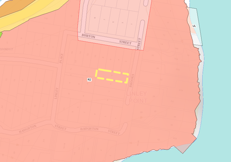
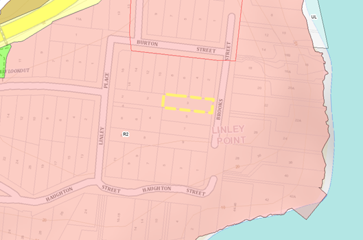
3 Brooks Street, Linley
Point
Subject: 3
Brooks Street, Linley Point
Record No: DA24/96-01 - 62447/24
Division: Planning
and Sustainability Division
Author(s): Sam
Wilson
|
Property:
|
3 Brooks Street, Linley Point
|
|
DA No:
|
DA96/2024
|
|
Date Lodged:
|
12/09/2024
|
|
Cost of Work:
|
$2,022,900.00
|
|
Owner:
|
Z Liu
|
|
Applicant:
|
Simon Shen
|
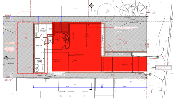
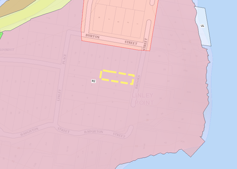
SITE
|
Property
|
Lot 23 DP 12774
|
|
Area
|
795.1m2
|
|
Site location
|
The subject
site is located on the western side of Brooks Street. It entails a
topographical crossfall from the northern boundary at approximately 38.50AHD
to the southern boundary at approximately 36.00AHD – a total decline of
2.5m.
|
|
Existing improvements
|
Existing
improvements consist of a 1-2 storey dwelling house that features an
unhabitable basement garage resultant of the sites topography. An existing
driveway crossover, 2 small ponds, and a detached garage shed are located on
the subject site.
|
|
Shape
|
Rectangular
|
|
Dimensions
|
North: 54.91m
South: 54.91m
East: 14.48m
West: 14.48m
|
|
Adjoining properties
|
Adjoining
properties consist of the following;
North: Single
storey dwelling house (No. 8 Burton Street), 2-storey dwelling house with an
in-ground swimming pool (No. 6 Burton Street), 2-storey dwelling house with
an in-ground swimming pool and detached outbuilding (No. 4 Burton Street),
and a 2-storey dwelling house (No. 2 Burton Street).
South:
2-storey dwelling house (5 Brooks Street)
West: 2-storey
dwelling house (2 Linley Place)
|
SITE APPLICATION HISTORY
No prior
development application history.
EXECUTIVE
SUMMARY
- The
development application was submitted via the NSW Planning Portal on 12 August
2024 for the demolition of existing dwelling house and
the construction of a 2-storey dwelling house with an in-ground swimming pool
and detached outbuilding;
- Council’s
planning officer issued a request for further information in the NSW Planning
Portal to revise the architectural plans to address the Lane Cove Development
Control Plan Part S Sustainability;
- The
applicant provided amended documentation on 13 August 2024;
- The
development application was accepted by Council via the NSW Planning Portal on
12 September 2024;
- The
development application was notified in accordance with Council’s policy
between 12 September and 28 September and received 4 submissions. The concerns
pertained to loss of solar access, bulk and scale, and view loss;
- A
secondary request for further information was submitted to the applicant to
revise the architectural plans, particularly, including the reduction of the
total basement garage area;
- Council’s
planning officer visited the subject site and adjoining neighbouring properties
of 4 Burton Street and 6 Burton Street on 30 September 2024;
- A
tertiary request for further information was submitted to the applicant to
provide a visual impact assessment and a letter of response addressing the 4
submissions from the neighbouring properties; and
- The
development application was referred to the Lane Cove Local Planning Panel on
30 September for its meeting scheduled for 22 October 2024.
PROPOSAL
|
The
development application seeks approval for the following demolition and
construction works at 3 Brooks Street, Linley Point;
Demolition:
- The
demolition of the existing dwelling house;
- The
excavation of the lower basement level; and
- The
removal of 11 trees.
Lower
Ground Floor Additions:
- Driveway
crossover;
- 2 space
basement garage including a turning bay;
- Media
room;
- Storage
room;
- Storage
area;
- Electricity
room;
- Lift core
structure; and
- Staircase
to service ground floor.
Ground
Floor Additions:
- Semi solid
front fence (maximum);
- Solid side
boundary fence;
- Driveway
crossover;
- Driveway;
- Front yard
entry pathway;
- Covered
porch;
- Entry
foyer;
- Family
room with a balcony;
- Bedroom 4;
- Bathroom;
- Laundry
with external access;
- Central
hallway;
- Central
courtyard with enclosing operable louvres;
- Feature
staircase to service first floor;
- Lift core
structure;
- Powder
room;
- Living
room;
- Dining
room;
- Kitchen
with a butler’s pantry;
- Covered
deck area with an outdoor barbecue structure;
- Levell
rear yard area;
- In-ground
swimming pool; and
- Cabana
with outdoor barbecue structure.
First
Floor Additions:
- Central
hallway;
- Planter
box;
- Living
area with an individual balcony;
- Front
façade planter box;
- Front void
over entry foyer;
- Rear void
over living and dining room;
- Bedroom 1
with a walk-in-robe, ensuite bathroom and an individual balcony;
- Bathroom;
- Bedroom 2
with a walk-in-robe, and ensuite bathroom;
- Bedroom 3;
- Bedroom 4;
and
- Rear
balcony.
Roof
Additions:
- 2o
box gable roof;
- 7 Velux
skylights;
- Solar PV
panels; and
- Skillion
roof pergola over rear balcony.
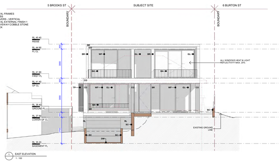
Figure 1: Front (East) Elevation of
Proposed Dwelling House (Source: Architectural Plans)
|
PROPOSAL
DATA/POLICY COMPLIANCE
Local Environmental Plan 2009
Zoning: R2 Low Density Site
Area: 795.1m²
|
LEP table
|
|
|
Development Standard
|
Proposal
|
Complies
|
|
Floor Space Ratio
(max)
|
0.5:1
|
0.5:1
|
Yes
|
|
Height of Buildings
(max)
|
9.5m
|
8.916m
|
Yes
|
LCLEP
6.1A Earthworks
The
development application proposes to demolish the existing structures on the
subject site and develop a two-storey single residential dwelling with a
2-space basement garage, an in-ground swimming pool and a detached
outbuilding. In order to accommodate for the basement garage, the
proposal seeks approval for earthworks. The excavation shown in the
architectural plans highlight that the earthworks would be undertaken from the
Brooks Street boundary frontage westwards approximately 30.5m to the middle
section of the site where the proposed basement footprint finishes. The maximum
depth of excavation on the subject site reaches approximately 2.3m; 1.3m in
exceedance of the maximum 1m provision established under Clause 1.6 of Councils
DCP. The total area of excavated soil would be approximately 200m2.
As established later in the report, Council considers the total proposed area
of excavation excessive. It is noted that the existing dwelling house entails a
lower ground level which is technically considered as a basement level as
highlighted by Figure 2 below;
Figure
2: Existing Basement Level (Source: Architectural plans drawn over by
Council’s Planner)
As a result
of the proposed excavation, the variation is assessed against Clause 6.1A of
the LCLEP regarding earthworks.
(1) The objectives of this clause are as follows—
(a) to ensure that earthworks for which development consent is
required will not have a detrimental impact on environmental functions and
processes, neighbouring uses, cultural or heritage items or features of the
surrounding land,
(b) to allow earthworks of a minor nature without requiring
separate development consent.
The assessment is as follows;
(3) Before granting development consent for earthworks, the consent
authority must consider the following matters—
(a) the likely disruption of, or any detrimental effect on,
existing drainage patterns and soil stability in the locality,
Comment: The existing drainage patterns present on the subject
site fall from northern boundary to the southern boundary at a difference of
approximately 2.5m. This is a classified as a considerable slope. Subsequently,
the existing dwelling house entails a split-level approach which sees the lower
level being currently utilised as a basement due to its unhabitable floor to
ceiling height. Council concurs that the 1.2m excavation depth within the
footprint of the existing basement would not adversely impact existing drainage
patterns or soil stability. However, the addition of approximately 60m2
of basement area at a maximum depth of 2.3m has the potential to contribute to
the disruption of the existing quality of soil on the site. The adjoining
property at 5 Brooks Street entails existing infrastructure that is built to
the boundary. With the significance of excavation at the section highlighted
below at a 1.2m distance from the boundary, there is the potential for undue
impacts to the existing condition of this neighbouring property.

Figure 3: Proposed Deletion of Basement Area (Source: Architectural
Plans drawn over by Council’s Planner)
The addition of a 3 separate basement rooms titled as ‘service
room’, ‘storage room’, and ‘electric room’, is
considered excessive, and would result in an over excavation of an R2 Low
Density Residential Site. This level of excavation is synonymous with
residential flat buildings and other larger developments. In effort to limit
potential structural and drainage impacts, Council recommends the deletion of
the above highlighted area.
With this, the existing topography at the frontage of Brooks Street would
be primarily retained in the proposal and the existing drainage patterns
present would not be envisaged to be impacted. This can be evidenced by the
comparison of images of the existing dwelling house and the proposed dwelling
house;
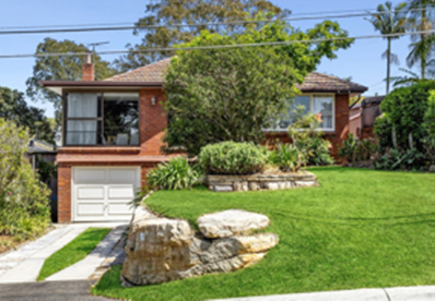
Figure 4: Existing Dwelling House (Source: BMA Urban)
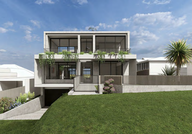
Figure 5: Proposed Dwelling House (Source:
Architectural Plans)
It is noted that the excavation works would be completed in accordance
with a revised geotechnical report that stipulates geotechnical engineering
measures to ensure minimal impact on that of the soil stability of the subject
site and neighbouring sites.
It has been conditioned that prior to construction and post-construction
the development is to obtain dilapidation reports and carry out several other
protective measures to ensure the works are carried out in accordance with
Council policy (C.5 - Dilapidation Report, E.12 – Cut and Fill, E.10
– Shoring and Adequacy, and F.3 – Post-Construction Dilapidation
Report). These are implemented to protect the drainage patterns, soil
stability, structural integrity of the adjoining properties and general amenity
of the neighbours.
Subject to compliance with the recommended conditions, the protection
against any potential damage to the site or adjoining properties would be
ensured. It is considered that there would be no adverse impact or detrimental
effect on the existing drainage patterns or stability of soil in the locality.
(b) the effect of the proposed development on the likely future
use or redevelopment of the land,
Comment: The proposed development would not have any adverse
impact on the future use or redevelopment of the land.
(c) the quality of the fill or the soil to be excavated, or
both,
Comment: The quality of the excavation would be monitored prior
to, during and after construction of the development. The respective conditions
would ensure that any adverse impacts would not occur during or after the
proposed excavation.
(d) the effect of the proposed development on the existing and
likely amenity of adjoining properties,
Comment: The proposed development would not have any adverse
impact on the access to sunlight or privacy of the adjoining properties, nor
would it create any major impacts on their general amenity.
(e) the source of any fill material and the destination of any
excavated material,
Comment: As previously mentioned, the quality/source of any
excavation and fill would be monitored prior to, during and after construction
of the development. The relevant conditions would ensure that no adverse
impacts would occur.
(f) the likelihood of disturbing relics,
Comment: The subject site is not identified as being within the
proximity of any Aboriginal heritage sites or having the potential to contain
any historical relics.
(g) the proximity to and potential for adverse impacts on any
watercourse, drinking water catchment or environmentally sensitive area.
Comment: The area is not identified as being environmentally
sensitive. The existing watercourses and drainage patterns would be retained in
the proposed development.
LDCP Part
B.4 – View Sharing
|
Part B.4 – View Sharing - DCP table
|
|
|
Provision
|
Proposal
|
Complies
|
|
(a) Retain existing
views
|
Where existing views from public spaces
are through the gaps between side setbacks of buildings, the length of the
building and roof of any proposal should be oriented towards the view in
order to minimise view obstruction.
|
The existing views
from the public space (Brooks Street and Burton Street) would not be
adversely impacted. The proposed roof would entail a 2o hip roof
that would be unperceivable from the streetscape.
The elongated form of
the proposed building envelope faces West towards Brooks Street, and further,
the Lane Cove River.
Particular emphasis
is given to the neighbouring properties at No. 4 Burton Street and No. 6
Burton Street. The existing allotment pattern sees the neighbouring
properties rear yards facing directly to the rear section of the proposed
building envelope. As established in the Tenacity section of the report,
there are no full, high-value water views or full, iconic land views that are
experienced from the ground floor or first floor of these two properties.
It is noted that 6
Burton Street experiences partial views of the Sydney CBD skyline across
several side boundaries. The extent of impact is discussed later in the
report.
|
Yes
|
|
(b) Water views from
the street
|
Existing or potential view corridors to
the water from the street are to be protected as public view corridors by
ensuring that fencing to the front boundary is open in character.
|
Water views to the
Lane Cove River can be achieved from Brooks Street, directly adjacent to the
subject site. These views are directly South of the site.
The development
proposes a 1.25m high semi-solid fence across the front boundary that is
predominately open in form and material. Given that the proposed fence is
setback between 2.3 and 3.1m from the kerb connection to Brooks Street, there
would be no incursion on the public corridor view to the Lane Cove River.
|
Yes
|
|
(c) Garages and outbuildings
|
Garages and outbuildings are not to be located
within the view corridor and the required side setback is to be clear of all
built form obstructions. Lightweight carport structures may be considered in
side setbacks.
|
The development
proposes a detached outbuilding in the form of a pool house/cabana that is
located within the rear setback. The proposed cabana complies with the
maximum height provision at an approximate 3.1m and is situated towards the
rear boundary.
It is noted that the
property at No. 8 Burton Street does not have access to high value water
views of the Lane Cove River, and therefore, the compliant outbuilding would
entail no impacts.
|
Yes
|
|
(d) Steeply sloping
sites
|
Buildings on steeply sloping sites should
adjust the height of the building envelope to follow the natural topography
of the site.
|
The subject site is classified as
considerably sloping.
|
N/A
|
|
(e) Proposed roof
designs
|
To facilitate view sharing for
residential developments, flat roofs, or low mono-pitched roofs can be used
where the design of the building and roof is integrated architecturally and
where its appearance would be appropriate given the character of the street.
|
As previously
mentioned, the 2o hip roof is generally considered flat, and would
be encapsulated by a parapet. The view from the street front would be that of
a modernist façade fenestration that features greenery in planter
boxes and a massing treatment that would be synonymous with the eclectic
character of Linley Point.
|
Yes
|
|
(f) Proposed roof
height
|
Applicants may not be able to achieve the
maximum permissible height in order to cater and facilitate view sharing. In
such cases, concessions shall be given for side and rear setbacks subject to
meeting the requirements for privacy, amenity, and solar access to the
adjoining neighbours. These concessions should be discussed with the Council
Officers prior to the lodgment of Development Applications.
|
The proposed dwelling
measures at a maximum height of 8.916m above the natural ground floor
– 584mm lower than the maximum permissible height. The building
footprint would be setback appropriately from the northern and southern
boundaries measuring at 1.5m and 1.2m accordingly. Therefore, the
proposed building envelope is considered reasonable. In respect to the city
views (No. 6 Burton Street), the skyline is partial, across side boundaries,
and difficult to protect given the existing allotment pattern and the
proposed compliant building envelope.
|
Yes
|
|
(g) Views form
commercial developments
|
Views from commercial development will
not carry the same weight as views from dwellings.
|
N/A
|
N/A
|
|
(h) Location of views
|
Development is not to unreasonably affect
existing water views from living areas of adjoining dwellings. Views from
bedrooms are not considered to have the same significance unless they are the
only available views within the dwelling.
|
As previously
mentioned, neither 6 Burton Street or 4 Burton Street experience any
high-value water views from a seated or standing position at the ground floor
or first floor.
|
Yes
|
|
(i) Reasonableness of
the views
|
In such cases the maintenance of the view
will be tested against its reasonableness i.e. how the view is obtained and
where the view is gained. For instance views that are gained by leaning out a
side boundary window and looking obliquely across a number of lots will not
be given weight against a view from the main living area window.
|
The primarily
impacted view is obtained from a standing position within the living area at
6 Burton Street. The view is partial and is achieved over several side and
rear boundaries.
|
See Tenacity
Assessment.
|
|
(j) View sharing
principle tests (Tenacity)
|
Views will also be tested against the
extent of view available. Where appropriate the views will also be tested
against the view sharing principles stated by the Land and Environment Court.
|
The views have been
assessed against the Tenacity principles used within the NSW Land and
Environment Court.
|
Yes
|
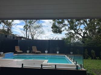
Figure
6: Ground Floor Living Room View from No. 6 Burton Street (Source:
Council’s Planner)
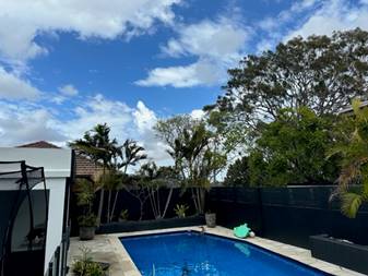
Figure
7: Lower Ground Floor View from No. 6 Burton Street (Source: Council’s
Planner)
Figure
8: Ground Floor Alfresco View from No. 4 Burton Street (Source: Council’s
Planner)
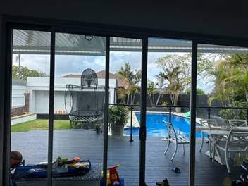
Figure
9: Ground Floor Living Room View from No. 4 Burton Street (Source:
Council’s Planner)
The
sharing of all views is part of the character of the Lane Cove area and should
be maintained where possible subject to how the view is obtained and whether
the maintenance of such a view creates an unreasonable impost on adjoining
landowners. Views gained across other privately-owned land are not “as of
right”, as some may depend on the property that is overviewed maintaining
a lower scale that is achievable under the LEP.
The Tenacity principle is a 4-step test implemented by the
Land and Environment Court for the purposes of view loss assessment. The
objectives of the B.4 View sharing section of the Lane Cove Council DCP 2010
outline the key components of this 4-step view sharing principle.
The
four steps of the Tenacity principle area are as follows:
· Step 1. Assessing the
types of views to be affected. Water views are valued more highly than land
views. Iconic views are valued more highly than views without icons. Whole
views are valued more highly than partial views.
· Step 2. Assessing what
part of the property the views are obtained. Side views are harder to protect
than rear or front views and seated views are harder to protect than standing
views and living rooms and kitchens are more valuable than bedrooms.
· Step 3. Assessing the
extent of the impact. This should be done for the whole of the property, not
just the view that is affected.
· Step 4. Assessing the
reasonableness of the proposal. A proposal which is fully compliant is more
reasonable than one which doesn’t comply, and proposals which have been
skilfully designed are considered more reasonable.
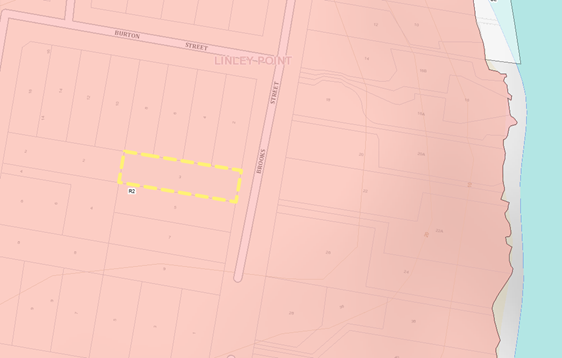
Figure
10: Location of Site (Source: Eplanning Spatial Viewer
In
order to assess the visual impact of the design proposal, it is necessary to
identify a suitable scope of publicly accessible locations that may be impacted
by it, evaluate the visual sensitivity of the proposal to each location and
determine the overall visual impact of the development. Accessible locations
that feature a prominent, direct and mostly unobstructed line of sight to the
development are used to assess the qualitative impact. The impact to each
location is then assessed by overlaying an accurate visualisation of the new
design onto the base photography and interpreting the amount of view loss in
each situation, together with potential opportunities for mitigation.
The
viewpoints as depicted in Figure (11) – Figure (18) have been taken from
2 specific neighbouring properties (4 Burton Street and 6 Burton Street). A
summarised view analysis from utilising the Tenacity principle is provided
below;
|
View
analysis
|
|
Property location
|
View Analysis
|
|
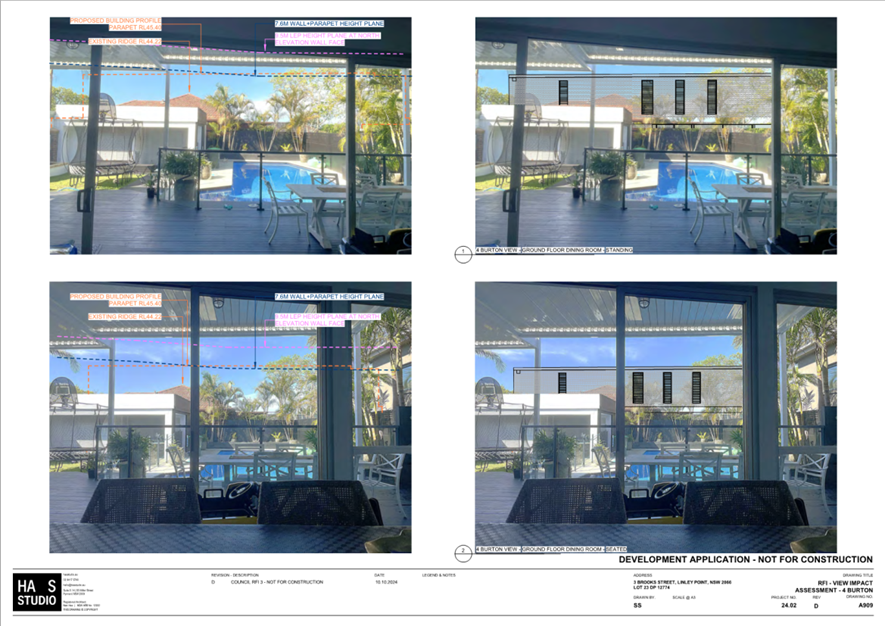
View 01: 6 Burton Street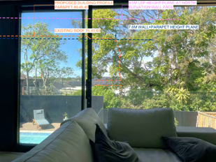
Figure 11: Existing View (Source: HAS)
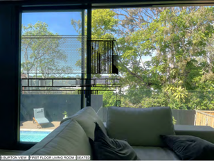
Figure 12: Proposed Design (Source: HAS)
|
Type
of View: The view entails low-value land
views to the neighbouring properties rear yard canopy.
Where
the views are obtained: The view is
obtained from the location of the living room of the ground floor level. The
view line is achieved from a standing position 1.60m above the Finished Floor
Level (FFL).
Extent
of Impact: The view that would be
primarily impacted is the rear boundary low-value land views to the yard of
the neighbouring property. A minor portion of the green outlook would be
thwarted by the proposed envelope. The low-value rear boundary land views
would be primarily retained.
Reasonableness
of Proposal: The part of the subject
development that would affect the view relates to the proposed building
envelope. The design complies with the relevant planning controls including;
- Height:
Complies with the 9.5m height development standard
- FSR:
Complies with 0.5:1 control where the design has a maximum of 0.5:1.
- Level of
Storeys: The revised design proposes a 2-storey dwelling house with a
basement.
- Vegetation: Significant existing vegetation is preserved in the
proposed design. Further, Council recommends the planting of additional
vegetative screen to increase the green-space outlook.
- Design:
The revised design presents a compliant building envelope that features
high-sill north-facing windows, adequate privacy screening, a flat-roof
design, and compliant side and rear setbacks.
Conclusion: When the view is a;
- Low-value land
view obtained from a standing position in an important location of the
dwelling house;
- There is minor
impact on the amount of views;
- The revised
proposal is considered to entail a respectful and skilful design
component;
Then the level of impact to existing views from the
living room are considered low and is therefore supported.
|
|
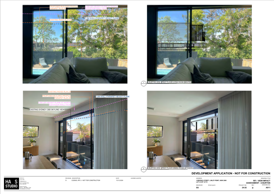
View 02: 6 Burton Street
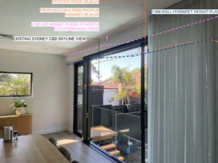
Figure 13: Existing View (Source: HAS)
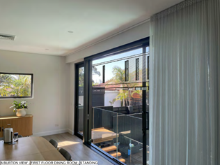
Figure 14:
Proposed Design (Source: HAS)
|
Type
of View: The view entails high-value
city skyline view of the Sydney CBD. However, the view is partial and
achieved across several side and rear boundaries subject to the existing lot
pattern.
Where
the views are obtained: The view is
obtained from the location of the living room on the ground floor level. The
view line is taken from a standing position 1.60m above the Finished Floor
Level (FFL).
Extent
of Impact: The views that would be
primarily impacted are the high-value views. The obstruction of city skyline
views would be significant.
Reasonableness
of Proposal: The part of the subject
development that affects the view relates to proposed first floor and general
building envelope. The following gives weight to the relevant planning
controls including;
- Height:
Complies with the 9.5m height development standard;
- FSR:
Complies with 0.5:1 control where the design has a maximum of 0.5:1;
- Level of
Storeys: The revised design proposes a 2-storey dwelling house with a
basement;
- Design:
The proposed building envelope is setback appropriately to preserve building
separation;
- Existing View
Circumstances: An indirect side boundary view that is primarily obscured
by existing dwellings and vegetation,
Conclusion: When the view is a;
- High-value city
skyline view obtained from a standing position in an important location of
the dwelling house;
- The existing
view is partial and obscured by existing conditions;
- The view line is
achieved over several side and rear boundaries which lower the significance
of protection of the view;
- The proposed
dwelling house is considered to entail a compliant envelope that feature
design components that respect amenity of neighbouring properties;
Then, the level of impact to existing views from the
living room would be supportable.
|
|
As a result, the impact on view
amenity is categorised for the three views using the Tenacity principles and
are as follows;
View 1: Low
View 2: Significant
Therefore, whilst the total
impact on view 02 experienced at 6 Burton Street would be categorised as
significant, mitigating factors stated above would constitute reason to
support the proposed development subject to compliance with the recommended
conditions of consent.
|
|
View
analysis
|
|
Property location
|
View Analysis
|
|
View 01: 4 Burton Street
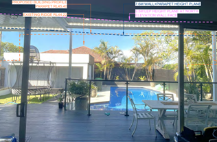
Figure 15: Existing View (Source: HAS)
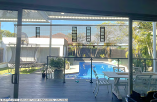
Figure 16: Proposed Design (Source: HAS)
|
Type
of View: The view entails low-value land
views to the neighbouring properties rear yard vegetation canopy.
Where
the views are obtained: The view is
obtained from the location of the dining room on the ground floor level. The
view line is taken from a standing position 1.60m above the Finished Floor
Level (FFL) and is achieved across the rear boundary of 4 Burton Street in
question, and the side boundary of the site in question.
Extent
of Impact: The view that would be
primarily impacted are the rear boundary low-value land views. Given the view
is low-value and no high-value views are experienced, the extent of impact
would be quantified as negligible.
Reasonableness
of Proposal: The part of the subject
development that affects the view relates to northern façade of the
proposed envelope. The following components of the design ensure compliance
with the relevant planning controls including;
- Height:
Complies with the 9.5m height development standard;
- FSR:
Complies with 0.5:1 control where the design has a maximum of 0.5:1;
- Level of
Storeys: The revised design proposes a 2-storey dwelling house with a
basement.
- Design:
The proposed building envelope would be set back appropriately from the
subject sites side boundary to preserve building separation. Additionally,
compliance with Council’s recommended conditions of consent would
obscure any direct overlooking between the two properties.
- Existing View
Circumstances: A direct rear boundary view to a low-value outlook that is
resultant of the existing lot pattern.
Conclusion: When the view is a;
- Low-value view
obtained from a standing position in an important location of the dwelling
house;
- There is no
high-value water, city skyline or iconic views; and
- The revised
proposal is considered to entail compliant and skilful design
components;
Then the level of impact to existing views from the
living room is considered low and is therefore supported.
|
|
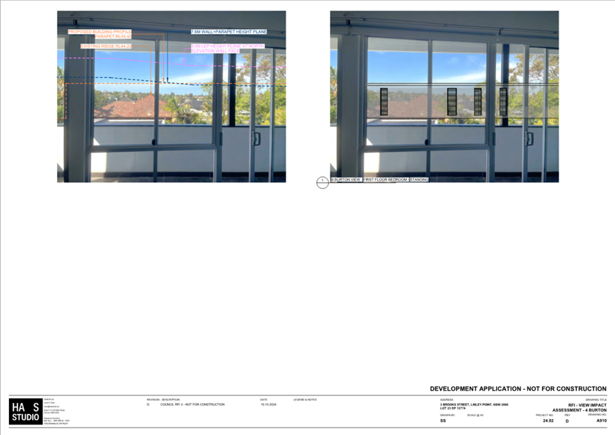
View 02: 4 Burton Street

Figure 17: Existing View (Source: HAS)
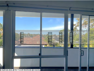
Figure 18:
Proposed Design (Source: HAS)
|
Type
of View: The view entails low-value land
views to the residential street canopies and beyond.
Where
the views are obtained: The view is
obtained from the location of the bedroom on the first-floor level. The view
line is taken from a standing position 1.60m above the Finished Floor Level
(FFL). It is noted that a standing view from this location is not of
significant importance to protect.
Extent
of Impact: The views that are primarily
impacted are the rear boundary low-value land views they would be impacted to
a negligible extent.
Reasonableness
of Proposal: The part of the subject
development that affects the view relates to proposed building envelope. The
design complies with the relevant planning controls including;
- Height:
Complies with the 9.5m height development standard;
- FSR:
Complies with 0.5:1 control where the design has a maximum of 0.5:1;
- Level of
Storeys: The revised design proposes a 2-storey dwelling house with a
basement.
- Design:
The proposed building envelope would be set back appropriately from the
subject sites side boundary to preserve building separation. Additionally,
compliance with Council’s recommended conditions of consent would
obscure any direct overlooking between the two properties.
- Existing View
Circumstances: A direct rear boundary view to a low-value outlook that is
resultant of the existing lot pattern.
Conclusion: When the view is a;
- Low-value view
obtained from a standing position in an unimportant location of the dwelling
house;
- There is no
water, city skyline or iconic of water views; and
- The revised
proposal is considered to entail compliant and skilful design
components;
Then
the level of impact to existing views from the bedroom is considered low and
is therefore supported.
|
|
As a result, the impact on view
amenity is categorised for the three views using the Tenacity principles and
are as follows;
View 1: Low
View 2: Low
Therefore, the total impact on
views experienced at 4 Burton Street as a consequence of the subject proposal
are considered reasonable subject to compliance with Council’s
recommended conditions of consent.
|
Comprehensive Development Control
Plan assessment
|
DCP table
|
|
|
Provision
|
Proposal
|
Complies
|
|
Front setback (min)
|
Consistent with area or 7.5m
|
GF: 7.5m
FF: 8.4m
|
Yes
Yes
|
|
Side setback (min)
North
|
1.2m single storey
1.5m two storey
|
LGF: 1.5m
GF: 1.5m
FF: 1.5m
|
Yes
Yes
Yes
|
|
Side setback (min)
South
|
1.2m single storey
1.5m two storey
|
LGF: 1.2m
GF: 1.2m
FF: 1.5m
|
Yes
Yes
Yes
|
|
Rear setback (min)
|
<1000m²: 8m or 25%
>1000m²: 10m or 35%
|
19.295m
|
Yes
|
|
Wall height (max)
|
7m + 600mm parapet for flat roof
structures
|
North façade:
7.42m
South façade:
8.415m
|
Yes
No – See
variations assessment.
|
|
Ridge height (max)
|
9.5m
|
8.916m
|
Yes
|
|
Number of storeys (max)
|
2
|
2 storeys and a
non-habitable basement (subject to compliance with Part A(g)).
|
Yes
|
|
Landscaped area (min) (Minimum dimension
of 1m)
|
35%
|
48%
|
Yes
|
|
Cut and
fill (max)
|
1m
|
Cut: 2.3m
Fill: 0.5m
|
No – See
variations assessment.
Yes
|
|
Solar access (min)
|
3 hours to north facing habitable windows
|
Note: All
habitable windows on ground floor of 5 Brooks Street are overshadowed by the
roof of the existing northern carport and pergola.
First Floor Window:
>3 hours.
|
Yes
|
|
Deck/balcony depth (max)
|
3m
|
Balcony 1 (FF -
front): 1.8m
Balcony 2 (FF -
front): 3m
Balcony 3 (FF –
rear ) 3m
|
Yes
Yes
Yes
|
|
Private open space (min)
|
24m² and 4m in depth
|
>24m2
|
Yes
|
|
BASIX Certificate
|
Required
|
1756580S
|
Yes
|
Car parking
|
Car parking table
|
|
|
Provision
|
Proposal
|
Complies
|
|
Off-street spaces (min)
|
1
|
2
|
Yes
|
|
Driveway width
|
3m at the kerb
|
5.9m – same as
existing
|
N/A
|
Carports within the front setback
& garages facing the street
|
Car parking structure table
|
|
|
Provision
|
Proposal
|
Complies
|
|
Setback of
carport posts (min)
|
1m from
street boundary
|
>1m
|
Yes
|
|
% of
allotment width (garages & carports)
|
50% of lot
width or 6m, whichever is the lesser
|
4m
|
Yes
|
Private swimming pools
|
Private swimming pool table
|
|
|
Provision
|
Proposal
|
Complies
|
|
Setback to
neighbour’s house (min)
|
3m to
waterline
|
15.2m to No. 6 Burton
Street
|
Yes
|
|
Setback to
boundary (min)
|
1m to
waterline
|
North: 4m
South: 1.5m
West: 1.3m
|
Yes
Yes
Yes
|
|
Height
(max)
(steeply
sloping sites)
|
1m
1.8m
|
In-ground.
|
Yes
|
|
Setback
from boundary if coping is above ground level (existing) (min)
|
Coping to
be set back at a ratio of 1:1
|
N/A
|
N/A
|
Fences
|
Fences table
|
|
|
Provision
|
Proposal
|
Complies
|
|
Front fence height (max)
|
Solid: 900mm
Lightweight: 1.2m
|
1.2m
|
Yes
|
|
Setback from front boundary if the height
is over 1.2m (min)
|
1m
|
N/A
|
N/A
|
|
Height of side and rear fences (max)
|
1.8m
|
1.8m
|
Yes
|
Outbuildings
|
Outbuilding table
|
|
|
Provision
|
Proposal
|
Complies
|
|
Overall
height (m) (max)
|
3.6m
|
3.1m
|
Yes
|
|
External
wall height (max)
|
2.4m
|
2.2m
|
Yes
|
|
Floor space
(max)
|
50m²
|
12m2
|
Yes
|
|
Number of
storeys (max)
|
1
|
1
|
Yes
|
|
Setback of
windows from boundaries (min)
|
900mm
|
1m
|
Yes
|
PART S ASSESSMENT
The proposed works amount to a cost over $250,000 and
therefore an assessment against the provisions of Part S Environmental
Sustainability is required.
|
S.2 Achieving Net-Zero
|
|
Provision
|
Provision
|
Proposal
|
Complies
|
|
2.1 All Electric
Buildings
|
All new developments
are to use electricity for all energy requirements associated with normal
operations.
|
BASIX Certificate
confirms an instantaneous gas hot water system is proposed.
Part A(h) is
recommended.
|
No – See
variations assessment.
|
|
2.2 On-site solar
|
Residential
development of three storeys or less will include the installation of a solar
PV system of no less capacity than 25% of the roof area.
|
25%
|
Yes
|
|
S.3 Resilience and Health
|
|
Provision
|
Provision
|
Proposal
|
Complies
|
|
3.1 Natural
Ventilation
|
a) For all
residential accommodation not affected by SEPP 65:
i. The natural
ventilation requirements of the NCC are to be met with the area of openings
to be calculated following the Apartment Design Guide Glossary definition of
Effective Open Area (EOA), including necessary allowance for insect screens.
ii. Windows are to be
located on multiple aspects to promote natural cross ventilation.
|
Complies.
|
Yes
|
|
3.2 Glazing
|
a) Window-to-wall
ratios of each major aspect are to be limited to a maximum of:
i. For residential
buildings, 30% when measured externally or 50% when measured on the internal
façade, whichever is lower. Windows and walls facing onto private open
spaces are excluded from the window-to-wall ratio calculation.
b) External solar
shading should be provided to glazing on the north, east and western facades
where it is not significantly over-shadowed by neighbouring buildings or by
the inclusion of balconies. The solar shading should be designed to maximise
the protection of the glazing from the summer sun and maximise solar
transmission in the winter sun.
d) Glazing is to be
selected with external solar heat and visible light reflectivity no greater
than 20% measured at normal incidence.
|
North: 7.05%
South: 16.8%
East: facing P.O.S
West: facing P.O.S
|
Yes
Yes
N/A
N/A
|
|
3.3 Urban Heat and
Shade
|
a) For low density
residential, at least 75% of the site area must comprise one or a combination
of the following when assessed in plan view:
i. Vegetation,
ii. Green roofs,
iii. Roofing
materials, including shade structures, with a minimum solar reflectivity
index (SRI) of 82 if a horizontal surface or a minimum SRI of 39 for sloped
surfaces greater than 15 degrees,
iv. Hardscaping
elements shaded by overhanging vegetation or roof structures,
v. Water bodies
and/or watercourses.
|
80.03%
|
Yes
|
|
3.4 Sustainable
Materials
|
a) All newly sourced
timber used in construction is to be FSC certified.
b) Alternatives
products are to be preferenced to replace materials that cause environmental
harm or health risks in manufacture, including materials containing
formaldehyde, chlorinated polymers, hydrochlorofluorocarbons and Halogenated
flame retardants.
c) Engineered stone
products must be handled in accordance with the appropriate standards.
|
Complies.
|
Yes
|
|
S.4 Integrated Urban Water Management
|
|
Provision
|
Provision
|
Proposal
|
Complies
|
|
4.1 Water Efficiency
|
a) All development
must demonstrate the prioritisation of water conservation measures to
minimise water consumption.
|
BASIX requires an
8500L rainwater tank to be provided.
Architectural plans
do not specify a RWT.
|
No – See
variations assessment.
|
|
4.2 Stormwater Management
|
a) Peak stormwater
flows are to be reduced with a stormwater detention system. Other measures
can include green roofs, stormwater harvesting, rain gardens, bio-retention
basins and passive filtration measures. Other water sensitive urban design
measures are described in Part J – Landscaping and Tree Preservation.
b) The use of porous
surfaces is to be maximised.
c) Where required,
Gross Pollutant Traps and filtration are to meet Sydney Water Best Practice
guidelines for reducing stormwater pollutants.
|
Complies.
|
Yes
|
REFERRALS
Development Engineer – Part O
– Stormwater Management
No objections
subject to recommended draft conditions.
Tree Assessment Officer – Part J
– Landscaping
No objections
subject to recommended draft conditions.
Assessment
- Environmental planning and assessment act 1979
provisions of any lep, dcp, SEPP or regulation
(Section 4.15(1)(a))
The proposal is
permissible and does not raise any issues in regard to the Lane Cove Local
Environmental Plan 2009.
The proposal
complies with the Floor Space Ratio development standard. The proposal also
complies with the Height development standard.
Other Planning Instruments
SEPP
(Resilience and Hazards) 2021
The subject site and adjoining sites are zoned for residential
purposes, however, are located within Coastal Environmental Areas. Given the
types of uses permissible within the residential zones, it is unlikely that the
site would be contaminated. Despite this, due to the proximity to the coastal
environment as well as the excavation present in the proposal, the development
is assessed against Clause 2.10 and Clause 2.11 of Resilience and Hazards SEPP.
2.10 Development
on land within the coastal environment area
Chapter 2.10 of the State Environmental Planning Policy (Resilience
and Hazards) 2021 (SEPP R&H 2021) aims to provide an integrated and
coordinated approach to land use planning in coastal zones in a manner
consistent with the Coastal Management Act 2016. The subject site is identified
as being within a Coastal Use Area.
Figure
2: Coastal Environment Area (Source: Eplanning Spatial Viewer)
In relation to
land in proximity to coastal environment area, the SEPP states the following:
(1) Development consent must
not be granted to development on land that is within the coastal environment
area unless the consent authority has considered whether the proposed
development is likely to cause an adverse impact on the following -
(a) the
integrity and resilience of the biophysical, hydrological (surface and
groundwater) and ecological environment, and
Comment: The
development would not constrain the integrity of the biophysical, hydrological
or ecological environment. The existing drainage patterns present on site would
be primarily retained. The moderate topographical decline from the northern
boundary to the southern boundary would ensure rainwater and general runoff
would travel in the same direction as existing.
(b) coastal
environmental values and natural coastal processes,
Comment: There would be minimal effects on the coastal environment or natural
processes as a result of the proposal. Potential impacts caused by the level of
excavation would be nullified by the significant distance between the altered
ground area and the foreshore.
(c) The
water quality of the marine estate (within the meaning of the Marine Estate
Management Act 2014), in particular, the cumulative impacts of the proposed
development on any of the sensitive coastal lakes identified in Schedule 1,
Comment: The
proposed development would not be located within the immediate vicinity of the
marine estate of the Lane Cove River. At its closest point, between the subject
site and the marine estate is a residential zone consisting of a neighbourhood
of single detached dwellings with front and rear landscape area which acts as a
natural buffer zone for any stormwater runoff that may enter into the body of
water. Therefore, the construction of the two-storey dwelling house within this
zone is not expected to create any adverse impacts on the quality of the marine
estate.
(d) marine
vegetation, native vegetation and fauna and their habitats, undeveloped
headlands and rock platforms,
Comment: The
proposal would not incorporate any potential alteration to the foreshore
boundary that adjoins the Lane Cove River.
(e)
existing public open space and safe access to and along the foreshore, beach,
headland or rock platform for members of the public, including persons with a
disability,
Comment: The
subject site does not entail any public open space or direct access to the
foreshore.
(f)
Aboriginal cultural heritage, practices, and places
Comment: The
subject site does not contain any Aboriginal cultural heritage or artefacts,
nor are any located within the vicinity.
Clause 2.11
Development on land within the Coastal Use Area
Chapter 2.11 of
the State Environmental Planning Policy (Resilience and Hazards) 2021 (SEPP
R&H 2021) provides a coordinated approach to lane use planning in coastal
use areas consistent with the Coastal Management Act 2016. The clause examines
the bulk, scale, and size of developments within coastal use areas and aims to
mitigate potential impacts on the surrounding environments.
Figure
3: Costal Use Area (Source: Eplanning Spatial Viewer)
The entirety of
the subject site is located within this area and is therefore assessed against
the following clauses of the SEPP;
(1)
Development consent must not be granted to development on land that is within
the coastal use area unless the consent authority
(a) has
considered whether the proposed development is likely to cause an adverse
impact on the following—
(i) existing, safe access to and along the foreshore, beach,
headland, or rock platform for members of the public, including persons with a
disability,
Comment: There is no existing public
accessways within direct proximity of the subject site, therefore, the proposed
development would not have any impact upon the public access to the foreshore.
(ii) overshadowing, wind funneling and the loss of views from public
places to foreshores,
Comment: The proposed development would
not generate any adverse overshadowing impacts to the neighbouring properties
or wind tunneling effects on the public sphere surrounding the site. As
evidenced by the Part B and Part C LCDCP compliance table, in addition to the
Tenacity assessment, the impact would be considered reasonable subject to the
adherence to Council’s recommended conditions of consent.
(iii) the visual amenity and scenic qualities of the coast,
including coastal headlands,
Comment: The subject site does not
experience any view lines to the coast or coastal headlands.
(iv) Aboriginal cultural heritage, practices, and places,
Comment: The subject site is not
identified as containing Aboriginal cultural heritage, practices, or places.
(v) cultural and built environment heritage, and
Comment: The subject site is not
identified as containing cultural or built environment heritage.
SEPP (Biodiversity and Conservation) 2021
The subject site is situated within a
‘Foreshores and Waterways Area’.
The proposal is assessed against Part 6.28,
Division 3 – Development in Foreshore and Waterways Areas as follows;
Development
in Foreshores and Waterways Area – 6.28 General (2)(e)
(1) In deciding whether to grant
development consent to development in the Foreshores and Waterways Area, the
consent authority must consider the following;
(a) whether the development is consistent with the following principles—
(i) Sydney Harbour is a public resource, owned by the public, to
be protected for the public good,
(ii) the public good has precedence over the private good,
(iii) the protection of the natural assets of Sydney Harbour has
precedence over all other interests,
(b) whether the development will promote the equitable use of the
Foreshores and
Waterways Area,
Comment: The subject site and proposed
development would entail no direct link or relationship to the foreshore and
waterways area. The subject site is in excess of 150m from the closest point to
the marine estate, therefore, there would be no impact on public accessibility,
ownership or protection.
(c) whether the development will have an adverse impact on the
Foreshores and Waterways Area,
Comment: As substantiated in previous sections of this report, the
development would not adversely impact upon amenities of the site related to
the foreshore areas such as the biological health of the ecosystem, the views
and outlooks of neighbouring properties, the existing vegetation, natural
assets or the general biodiversity and conservation.
(e) whether the development will minimise risk to the
development from rising sea levels or changing flood patterns as a result of
climate change,
Comment: The proposed development would not be a risk to the
potentials of rising sea levels or changing flood patterns.
(f) whether the development will protect or reinstate natural
intertidal foreshore areas, natural landforms and native vegetation,
Comment: The development proposes the removal of 11 tree species
that have been determined by the submitted arborist report to be in
insignificant, particularly T3, T4, T5, T6, T7, T9, T11, T12, T14, T15, and
T16. However, the landscape plan completed by EcoDesign proposes the
reinstatement of several of the removed trees to offset canopy loss.
Council’s arborist has undertaken an assessment that has informed several
conditions of consent that would ensure the reinstatement of suitable species
that would improve upon the proposed canopy coverage. The removal and
subsequent reinstatement of these species would not adversely impact on the
structural quality of the subject site, nor would it adversely alter the
natural ground level. Additionally, given the significance of distance between
the site and the foreshore, there would be no adverse environmental impact on
the marine estate.
(g) whether the development protects or enhances terrestrial and
aquatic species, populations and ecological communities, including by avoiding
physical damage to or shading of aquatic vegetation,
Comment: The proposal would not entail any direct relationship to
terrestrial/aquatic species and would not overshadow any aquatic vegetation.
(h) whether the development will protect, maintain or
rehabilitate watercourses, wetlands, riparian lands, remnant vegetation and
ecological connectivity.
Comment: It is envisioned that the natural watercourses present on
site would be minimally affected by the proposed development. Potential impacts
caused by the level of excavation are nullified by the significant distance
between the altered ground area and the foreshore – whereby the natural
watercourses are ultimately maintained.
The proposed development would
not satisfy the matters (sub provision C and F) listed within Section 6.28 of
the Biodiversity and Conservation SEPP of 2021.
APPLICABLE REGULATIONS
The
Environmental Planning and Assessment Regulation 2021 indicates that the
standards for demolition and removal of materials should meet with AS 2601-2001
and therefore any consent would require the application of a relevant condition
seeking compliance with this Standard.
Variations to Council’s Codes/PolicIes
The preceding
policy assessment tables identify those controls that the proposal does not
comply with. Each departure is discussed below.
|
Control
|
Proposed
|
Comment
|
Council support
|
|
Clause 1.7.1(a) – Maximum wall
height – 7m (600mm parapet)
|
North façade:
7.42m
South façade:
8.415m
|
Consequent of the sloping natural ground
line, the maximum wall height would exceed the 7.6m provision by 815mm.
Council is in support of the variation as no adverse impacts would result.
|
Yes
|
|
Clause 1.6 – Cut and Fill –
1m
|
Cut: 2.3m
Fill: 0.5m
|
The development proposes a 2.3m
excavation in order to accommodate for the basement level. The variation is
supported subject to compliance with the recommended conditions of deferred
commencement consent.
|
See conditions of
deferred commencement consent.
|
|
Clause 2.1 – All Electric Buildings
|
BASIX Certificate
confirms an instantaneous gas hot water system is proposed.
|
The proposed development incorporates the
use of a gas instantaneous hot water system. Council is not in the support of
any gas systems for new residential developments.
|
No – See
conditions of deferred commencement consent.
|
|
Clause 4.1 – Water Efficiency
|
BASIX requires an
8500L rainwater tank to be provided.
Architectural plans
do not specify an RWT.
|
The architectural plans fail to
demonstrate an 8500L rainwater tank. Council is not in support of the
contravention of this provision.
|
No – See
conditions of deferred commencement consent.
|
The
alterations and additions seek approval for the variation of 4 provisions
within the LDCP 2009, particularly, Part C Clause 1.7.1(a) Maximum Wall Height,
Part C Clause 1.6 Cut and Fill, Part S Clause 2.1 All Electric Buildings, and
Part S Clause 4.1 Water Efficiency. This section identifies the controls in
which the development does not comply with. The non-compliance with Clause 2.1
and Clause 4.1 of the Part S Sustainability DCP is not supported and has been
conditioned accordingly. The following measures ensure the mitigation of any
potential impacts of the departures, Clause 1.7.1(a), and Clause 1.6;
Part C
Clause 1.7.1(a) – Maximum Wall Height
Part C1.7.1(a) stipulates that proposed residential
developments are limited to a maximum wall height of 7m from the existing
ground level. The development proposes a wall height of 8.415m at the southern
façade of the dwelling house. This breaches the control by 815m (when
accounting for the 600mm parapet allowance), however, the following reasons
ensure acceptability based on merit;
- As previously mentioned, the overshadowing generated by
proposed building envelope would incur negligible impacts as the adjoining
properties achieve a minimum of 3 hours of direct sunlight at the Winter
solstice;
- The building design would successfully utilise in-stepping,
and courtyard typology design in accordance with relevant setbacks to reduce
the visual bulk and scale;
- The proposed southern facade would entail minimal glazing
and window openings on the first floor which would decrease potential impacts
subject to cross-boundary overlooking. Ultimately, the wall height would not
contribute to any privacy or amenity impacts; and
- The proposed design achieves a scale and appearance which
is in keeping with the predominant bespoke, modernist existing and emerging
street and neighbourhood character of Brooks Street and the greater Linley
Point locale;
Part C
Clause 1.6 Cut and Fill
Part C 1.6
stipulates a maximum cut and fill 1m across the subject site. The development
proposes a total fill of 1.7m, thus exceeding the provision. The extent of
excavation is considered reasonable to allow for a levelled entry to the
dwelling house on a steeply sloping site. The variation is supported as per the
following;
- The
subject site entails a topographical crossfall from the northern boundary at
approximately 38.50AHD to the southern boundary at approximately 36.00AHD
– a total decline of 2.5m over a 14.48m course. This is a conservable
slope. It presents a level of inaccessibility that is inconsistent with
modern standards, highlighting that disabled access and ageing-in-place would
be disadvantaged as a result. The cut and fill would result in a more
accessible dwelling house and generally, a better planning outcome;
- The existing character of a steeply sloped
front yard would be preserved by a closely replicated landscape design. This is
considered to maintain a consistent relationship between the development and
the existing streetscape; and
- Subsequent to the
existing steep decline of the site, maintenance of the existing side setbacks,
and the large unaltered landscaped area at the rear of the dwelling house, it
is considered that the existing drainage patterns would not be adversely impacted
by way of the proposed fill.
Part S Clause
4.1 Water Efficiency
Clause 4.1 of
the Part S LDCP states that all development must
demonstrate the prioritisation of water conservation measures to minimise water
consumption. The applicants statement of environmental effects confirms that;
The proposal incorporates on-site stormwater retention and re-use
measures in the form of a rainwater tank to collect stormwater runoff from the
roof areas. Permeable paving is to be used for a large proportion of the
driveway to enable some degree of infiltration.
However, the
provision of any such rainwater tank has not been specified on the submitted
architectural plans. Council recommends Part A for the applicant to specify the
location, make, and compliance with the BASIX Certificate on the architectural
plans.
Part S
Clause 2.1 All Electric Buildings
Clause 2.1 of
the Part S LDCP states that all new developments are to use only electricity
for all energy requirements associated with normal operations. The objectives
for all-electric buildings are to:
1. Minimise the installation of plant and equipment in new buildings
that rely upon on-site fuel combustion.
2. Reduce indoor and outdoor air pollutants associated with the
combustion of gas or wood and improve air quality.
3. Reduce the cost to occupants by avoiding ongoing gas connection
standing charges.
4. Reduce the contribution of gas combustion to the anthropogenic heat
contribution flux in the urban area.
The
development application proposes a gas instantaneous hot water system as
evidenced in BASIX Certificate 1756580S.
The provision of any gas services is in direct contravention of the 4
objectives within Clause 2.1 and is not supported. Subsequently, Part A(h) is
recommended.
IMPACTS OF
DEVELOPMENT (Section 4.15(1)(b))
The proposal
would not adversely impact neighbouring properties or the public domain in
terms of overshadowing, visual privacy, acoustic privacy, or traffic and
parking. The proposal presents a development outcome that is consistent with
the objectives of the relevant planning controls.
SUITABILITY
OF SITE (Section 4.15(1)(c))
The subject site
would be suitable for the proposed development as the proposed use is
permissible within the Zone. The proposed development would positively
contribute to the amenity of the surrounding area and the subject site
constrain the development or neighbouring sites.
RESPONSE
TO NOTIFICATION (Section 4.15(1)(d))
|
Concern
|
Comment
|
|
Concern raised for the bulk and scale of
the proposed development.
|
Bulk and scale
is assessed under the following subcomponents; development height, FSR, side
setbacks, front and rear setbacks, and maximum wall heights. The proposal
complies with all subcomponents excluding the wall height. The wall height
variation is resultant of the existing topography of the subject site and
would not amount to any material or amenity related impacts to the property
in question.
|
|
Concern for the obstruction of existing
views.
|
As established
in the preceding Tenacity assessment, the property does not entail any full
high-value water views, iconic views, or city skyline views. The existing
views are low-value land views and therefore, the extent of impacts would
range between the categorisation of negligible to low.
|
|
Concern for privacy in the rear yard
resultant of the proposed building envelope.
|
Council
concurs with the potential privacy impacts to the sites rear yard. Privacy
screens and obscured window glazing is recommended under Part A(c) to protect
the amenity of the site in question.
|
|
Concern for the number of storeys in the
proposed development.
|
The proposed
development was amended to delete the habitable rooms located at the basement
level. Furthermore, Council recommends additional conditions of consent to
restrict the proposed basement to the total area of the existing basement.
|
|
Concern raised for exceedance of the
maximum allowable wall height.
|
As previously
mentioned in the report, the variation of wall height on both the northern
and southern façade of the building envelope would not result in any
adverse reduction of solar access to the neighbouring properties or bulk and
scale that is discordant from the existing or emerging neighbourhood
character. It is noted that the privacy impacts to the neighbouring property
in question are addressed in the recommended conditions of consent.
|
|
Concern for the total amount of
excavation.
|
The total
volume of excavation was reduced in the amended architectural plans. Council
concurs that the amended level of excavation remains in significant
exceedance of the provision, hence, the recommendation to minimise the area
of excavation in effort of reducing potential impacts.
|
|
Concern
|
Comment
|
|
Concern for the view loss experienced
from the ground floor living room.
|
As evidenced
by the Tenacity assessment, the high-value city skyline view is a partial
view that is achieved across several boundaries, is not readily perceivable
from the internal area, and experiences a high level of existing obscurement.
The view is
categorized as a high-value view, however, is reduced in importance due to
the unfavorable existing site allotment circumstance. As mentioned in
Tenacity, side boundary views are difficult to protect, and are generally
given less weight in assessments. The site in question achieves its views
across three side boundaries as shown in the figure below.
The proposed
development would present a primarily compliant building envelope that
adheres to the development height and floor space ratio standards, front,
rear, and side boundary setbacks. The variation to the maximum wall height is
not considered to wholly influence the view loss results.
For
example, if the total building height was reduced by approximately 2m, there
would be no material change in view obstruction. In order to retain the
existing city views, the proposed development would be required to be
restricted to 1 storey – an onerous restriction that Council would
consider unreasonable.
|
|
Concern that the development is contrary
to the R2 Low Density Zone objectives.
|
The
development proposes a two-storey detached dwelling house in a low-density
residential zone. The proposed detached dwelling house would be compliant
with the height and FSR development standards applicable to the subject site.
The design is cohesive with the existing and emerging modern character of
Linley Point, and it adequately addresses the need for more accessible,
improved low density housing.
|
|
Concern for the general bulk and scale of
the proposed dwelling house.
|
It has been
previously established that the proposal is largely compliant with Councils
development controls for height, floor space, setbacks, and articulation. The
compliance with these components would ensure that bulk and scale is
replicative of the neighbouring properties and would not result in an over
development of the subject site.
|
|
Concern for the proposed character of the
dwelling house and its potential impact on the streetscape.
|
The immediate surroundings of the site feature a diverse range of
residential options, being mostly detached dwellings. These buildings
showcase a blend of architectural styles, encompassing both traditional and
contemporary designs. The area's development history spans different eras,
leading to a mixture of construction materials and finishes. As a result, the
area poses an eclectic character of the neighbourhood. The locality has a
residential, leafy character characterised by a streetscape quality of side
setbacks and predominant landscape. The compliant building height would
reinforce the existing scale of the area and the setbacks would follow the
existing building of Brooks Street.
The proposal is carefully considered, with material choices
specific and responsive to its location. Massing, detailing and the
utilisation of planter boxes across the facades responds to both the
emerging modern character of Linley Point and the existing traditional
greenscape.
The building's architecture and material selection result in an
articulated facade, with natural-toned concrete providing a contrast against
the paler outer form, visually reducing the mass. This material palette is responsive
to the eclectic mix of surround styles prevalent in the neighbourhood and
incorporates fine grain textures to integrate the proposal harmoniously
within the site.
|
|
Concern for the number of storeys
|
Council
addressed the concern for the number of storeys in its initial Request for
Further Information where the following statement was made;
As evident in the below figure, the proposed develop incorporates
3-levels. The departure is significant and is in direct contravention of
Clause 1.7.1(e). Highlighted in red below, the media room, living room and
bedrooms are considered habitable rooms, located directly above one another
on separate floor plates. Council cannot support the departure.
Council acknowledges that the existing
dwelling house entails a basement level due to the existing topography of the
subject site. Whilst this is existing, the proposed development would
excavate a further +1m across the basement footprint, as well as an
additional 95m2 (approximately)
for ‘storage’, ‘media’ (habitable space),
‘electric’, and a lift structure. This
area of excavation at a maximum depth of approximately 2.6m is excessive, in
direct contravention of Clause 1.6, and Clause 1.7.1(e) of the LCDCP, and
ultimately, is not supportable. It is recommended that the area highlighted
above in red is removed from the design.
It is noted
that whilst the revised architectural design removes the habitable room at
this level, the excavation required is still considered excessive. Part A(a)
is recommended to maintain a similar basement area as the existing basement
on the subject site.
|
|
Concern
|
Comment
|
|
Concern raised for the bulk and scale of
the proposed development.
|
As mentioned
previously in the objection section of the report;
Bulk and scale is assessed under the following subcomponents;
development height, FSR, side setbacks, front and rear setbacks, and maximum
wall heights. The proposal complies with all subcomponents excluding the wall
height. The wall height variation is resultant of the existing topography of
the subject site and would not amount to any material or amenity related
impacts to the property in question.
|
|
Concern for the obstruction of existing
views.
|
As mentioned
previously in the objection section of the report;
As established in the preceding Tenacity assessment, the property
does not entail and high-value water views, iconic views, or city skyline
views. The existing views are low-value land views and therefore, the extent
of impacts would range between the categorisation of negligible to low.
|
|
Concern for privacy in the rear yard
resultant of the proposed building envelope.
|
As mentioned
previously in the objection section of the report;
Council concurs with the potential privacy impacts to the sites
rear yard. Privacy screens and obscured window glazing is recommended under
Part A to protect the amenity of the site in question.
|
|
Concern for the number of storeys in the
proposed development.
|
As mentioned previously in the objection
section of the report;
The proposed development was amended to delete the habitable rooms
located at the basement level. Furthermore, Council recommends additional
conditions of consent to restrict the proposed basement to the total area of
the existing basement.
|
|
Concern raised for exceedance of the
maximum allowable wall height.
|
As mentioned previously in the objection
section of the report;
As previously mentioned in the report, the variation of wall
height on both the northern and southern façade of the building
envelope would not result in any adverse reduction of solar access to the
neighbouring properties or bulk and scale that is discordant from the
existing or emerging neighbourhood character. It is noted that the privacy
impacts to the neighbouring property in question are addressed in the
recommended conditions of consent.
|
|
Concern for the total amount of
excavation.
|
As mentioned previously in the objection
section of the report;
The total volume of excavation was reduced in the amended
architectural plans. Council concurs that the amended level of excavation
remains in significant exceedance of the provision, hence, Council recommends
the proposed basement excavation to be of a similar area to the existing
basement in effort of reducing potential impacts.
|
|
Concern
|
Comment
|
|
Concern for overshadowing and the
potential impact upon future solar PV panels on the neighbouring properties
roof.
|
Council can
confirm that the proposed development would not adversely impact the solar
access of the southern adjoining property. The building envelope would allow
for the minimum 3 hours of direct solar access to the habitable first floor
rooms. The solar diagrams provided highlight the large area of the existing
roof that experiences solar access throughout the day on June 21, therefore,
ensuring minimal overshadowing of future solar PV panels.
|
PUBLIC INTEREST (Section 4.15(1)(e))
The proposal would not have an unreasonable
impact on neighbouring properties or the public domain with regard to the Lane
Cove LEP 2009, Lane Cove DCP 2009 or any other environmental planning
instruments. Therefore, approval of this application would not be contrary to
the public interest.
CONCLUSION
The matters in
relation to Section 4.15 of the Environmental Planning and Assessment Act 1979
have been satisfied.
The application
complies with the Floor Space Ratio development standard of the Lane Cove LEP
2009. The proposal also complies with the Height development standard of the
Lane Cove LEP 2009.
The application
generally meets with the Part C Residential Development Objectives of the Lane
Cove Development Control Plan 2009.
On balance, the
proposed development would be reasonable it is therefore recommended for
approval subject to the satisfaction of the conditions under the deferred
commencement consent.
|
RECOMMENDATION
PART A – DEFERRED
COMMENCEMENT CONSENT
That pursuant to Section 4.16(1)(a) of the Environmental Planning
and Assessment Act 1979, the Lane Cove Local Planning Panel at its meeting of
22 October 2024 grants a deferred commencement development consent to
DA96/2024 for the demolition of existing dwelling house and the construction
of a 2-storey dwelling house with an in-ground swimming pool and detached
outbuilding, subject to the addressal of the following matters:
Design Amendments: The
following amendments are to be made to the architectural plans;
a) Reduction of Basement Area: The areas
specified as ‘storage’, ‘service room’, and
‘cbus/electric’ are to be removed from the basement floor plan.
This area is highlighted in the figure below;
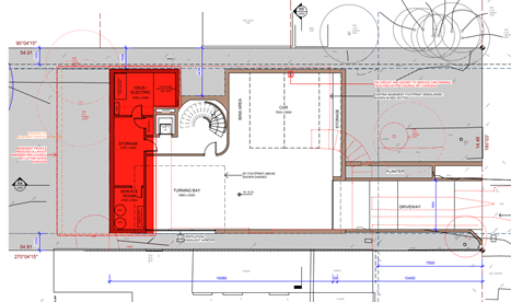
b) Amendment of Swimming Pool Fence: The proposed
swimming pool fence that surrounds the perimeter of the pool is to be free of
any ancillary structures (cabana). In order to comply with the Australian
Standards, the amended fence line is to follow the perimeter outlined in the
below figure;
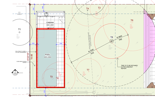
c) Amendment of Windows: The 4 north-facing
windows located on the first floor of the proposed development are to be
obscured glazing. The windows are specified in the figure below;
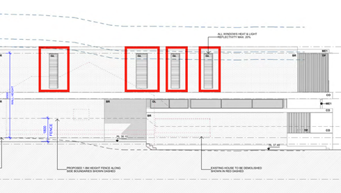
d) Addition of Privacy Screens: The balcony
accessed via Bedroom 1 (first floor) is to have a 1.8m privacy screen at the
northern extent. The privacy screen is to have an opening-to-batten ratio no
greater than 0.5:1.
e) Addition of Privacy Screens: The balcony
accessed via the Seating Room (first floor) is to have a 1.8m privacy screen
at the southern extent. The privacy screen is to have an opening-to-batten
ratio no greater than 0.5:1.
f) Addition
of Vegetation: The northern side boundary is to incorporate the following
planting schedule;
§ (4) x 100L Elaeocarpus eumundi
(Quandong) trees are to be planted to provide building screening.
The area of vegetation is to
span between front of the proposed dwelling to the rear. This is highlighted
in red in the figure below;
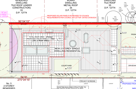
g) Specification of Rainwater Tank: The
architectural plans are to be updated to clearly depict the location of the
8,500L rainwater tank specified under BASIX Certificate 1756580S.
h) Removal of Gas Systems: BASIX Certificate
1756580S is to be amended to delete the provision of the instantaneous gas
hot water system.
i) Retainment of the Northern Boundary Wall: The
architectural plans by HAS Studio dated 10/10/2024 issue D are to be amended
to retain the existing boundary wall on the northern side of the property.
This wall is within the Tree Protection Zone of Tree 13 and Tree G1. The
retainment is to protect the root systems of the neighbouring palm trees.
j) Retainment/Replacement of Trees: The Landscape plan by Eco Design dated 2.7.24 issue B is
to be updated to reflect the following:
· Tree 7 Magnolia grandiflora is to
be retained;
· The Elaeocarpus reticulatus
proposed for the front of the property is to be substituted for a 100L Angophora
costata, with the proposed Banksia serrata to be updated to a 100L
Banksia serrata to offset canopy loss to comply with LCDCP part J
section 3.5 and 3.6.
|
PART B – CONDITIONS OF CONSENT
Subject to the
matters under Part A above being satisfied to the satisfaction of Council, an
Operative Consent and plans be issued subject to the following conditions:
General Conditions
That pursuant to
Section 4.16(1)(a) of the Environmental Planning and Assessment Act 1979, the
Council grants development consent to:
· Development Application DA96/2024
· For the demolition of existing dwelling house and the construction
of a 2-storey dwelling house with an in-ground swimming pool and detached
outbuilding
· On 3 Brooks Street, Linley Point
subject to the
following conditions:
That the development be strictly in accordance with:
· Drawing number/s TO BE INSERTED
· Dated
· By
except as amended by the following conditions.
Reason: To ensure the development is in
accordance with the determination.
1. A.3 - Payment of security deposits
Before the commencement of any works on the site or the issue of a
construction certificate, the applicant must make all of the following payments
to Council and provide written evidence of these payments to the Certifier:
|
Security deposit
|
Revision
|
|
Infrastructure damage bond
|
$5,000.00
|
The payments
will be used for the cost of:
· making
good any damage caused to any council property (including street trees) as a
consequence of carrying out the works to which the consent relates,
· completing
any public work such as roadwork, kerbing and guttering, footway construction,
stormwater drainage and environmental controls, required in connection with
this consent, and
Reason: To
ensure any damage to public infrastructure is rectified and public works can be
completed.
2. A.4 - Payment of building and construction industry
long service levy
Before the issue of a construction certificate, the applicant is to
ensure that the person liable pays the long service levy of $5057.00 as
calculated at the date of this consent to the Long Service Corporation or
Council under section 34 of the Building and Construction Industry Long
Service Payments Act 1986 and provides proof of this payment to the
certifier.
Reason: To
ensure the long service levy is paid.
3. A.7.L - Tree preservation and approved landscaping
works
The protection
of trees in Lane Cove is regulated under the State Environmental Planning
Policy (Biodiversity and Conservation) 2021 (SEPP) parts 2.2 and 2.3 which
prohibits the clearing of vegetation without the authority conferred by a
permit granted by Council. Clearing under the SEPP is defined as:
a) cut down, fell, uproot,
kill, poison, ringbark, burn or otherwise destroy the vegetation, or
(b) lop or otherwise remove a substantial part of the vegetation.
The clearing of trees or vegetation
protected by the regulation is an offence against the Environmental Planning
and Assessment Act 1979 (NSW).
The maximum
penalty that may be imposed in respect to any such offence is $1,100,000 per
individual and $5,500,000 per corporation.
The
following trees shall be retained:
|
Tree No.
|
Species
|
Location
|
Dimension (metres)
|
|
1
|
Archontophoenix
cunninghamiana
|
Neighbouring tree
|
11 x 2
|
|
2
|
Hymenosporum
flavum
|
Neighbouring tree
|
10 x 3
|
|
7
|
Magnolia grandiflora
|
Rear of property
|
6 x 2
|
|
8
|
Corymbia
citriodora
|
Rear of property
|
16 x 9
|
|
10
|
Melaleuca
quinquenervia
|
Neighbouring
property
|
17 x 6
|
|
13
|
Archontophoenix
cunninghamiana
|
Neighbouring
property
|
7 x 1.8
|
|
G1
|
Archontophoenix
cunninghamiana
|
Neighbouring
property
|
7 x 1.5
|
This consent gives approval for the removal of the
following trees:
|
Tree No.
|
Species
|
Location
|
Dimension (metres)
|
|
3
|
Buckinghamia spp
|
Rear of property
|
7 x 1.5
|
|
4
|
Viburnum tinus
|
Rear of property
|
4 x 2.5
|
|
5
|
Camellia sasanqua
|
Rear of property
|
4.5 x 1.5
|
|
6
|
Banksia
integrifolia
|
Rear of property
|
9 x 2.5
|
|
9
|
Toona australis
|
Rear of property
|
8 x 5
|
|
11
|
Calodendron
capense
|
Rear of property
|
8 x 2.5
|
|
12
|
Calodendron
capense
|
Rear of property
|
8 x 2.5
|
|
14
|
Magnolia soulangiana
|
Front of property
|
4 x 2
|
|
15
|
Camellia
sasanqua
|
Front of property
|
2.5 x 1
|
|
16
|
Callistemon
viminalis
|
Front of property
|
3 x 1.5
|
This
consent gives approval to carry out the following works in Tree Protection
Zones:
|
Tree No.
|
Species.
|
Location
|
Permitted
works in TPZ
|
|
7
|
Magnolia
grandiflora
|
Rear of
property
|
Installation
of stormwater
|
|
8
|
Corybmia
citiodora
|
Rear of
property
|
Construction
of rear of property
|
No tree pruning is permitted as part of this consent unless otherwise conditioned.
Any tree pruning requires a formal Tree Works Authority Application to be made
to Council.
Reason: To ensure the protection of trees to be retained and to
confirm trees removed for pruning/removal.
4. A.9. - Works on Council land
Separate application shall be made to Council’s Open Space and
Infrastructure Division for any associated works on Council property. Written
approval is to be obtained prior to the start of any works on Council property.
Reason: To manage impacts to Council’s assets.
5. A.10.E - Drainage plan amendments
Before the issue of a construction certificate, the certifier must
ensure the approved construction certificate plans (and specifications) detail
the following required amendments to the approved stormwater drainage plans
prepared by Hyten Engineering, reference No: 24H 186, revision: B and dated in
15/07/24. This amended plan shall satisfy Part O of the Council’s
stormwater DCP.
1. All new down pipes shall be connected to
appropriate pipe system.
2. All inlet pits are to be 450mm*450mm size
in minimum.
3. Proposed drainage system should show pipe
sizes and invert levels up to the connection point; confirming pipe system
satisfies Part O of Council’ storm water DCP.
4. Sediment control fence shall be placed
around the construction site and shown in plan.
5. The stormwater requirements shown in
Basix certificate shall be included in stormwater management plan and
satisfied.
6. Subsoil seepage agg-line drainage is
required around proposed retaining wall, dwelling, basement or as it is
necessary and connected to proposed drainage system.
7. A rainwater
tank shall be included into storm water management plan as per Basix
certificate.
8. Clean out pits are required at all low
points of charged drainage line if charged pipe system is proposed.
9. A pollution
control pit (as shown in section 3.4.1 in Part O of Council’s stormwater
DCP) with mesh (RH3030) and sump (300mm minimum) is required within the site,
at start of the connection pipe to the Council kerb system. These details shall
be shown in plan.
10. The stormwater runoff from driveway shall be
collected by grated driveway pit and connected to pump out system. The pump
system should be connected to pollution control pit.
11. Driveway grated strip pit shall have minimum 200mm
of depth and minimum 1% fall inside.
12. Minimum of 1.8m height difference is required
between start and end of the charged pipe system as per section 5.1 in Council
DCP if charged system is used. The details of design level difference shall be
shown in plan.
13. The
kerb connection pipe from fence line to kerb shall be designed for gravity
discharge only and no charged pipeline allowed.
14. The kerb discharge point shall be minimum 300mm away
from edge of driveway wing and complied with section 4.1 in Council DCP.
15. Bends on kerb discharge pipe from site to Council
kerb are not allowed.
16. Only roof water shall be connected to rainwater
tank.
17. The rainwater tank shall show top water level,
overflow path detail and pump system.
18. The proposed basement shall be constructed with
water-proof walls around the basement.
19. A suitable pump out system is required inside the
basement and shall satisfy section 5.4 of part O of Council’s stormwater
DCP. The full details of the hydraulic calculation for pump out system shall be
included in stormwater management plan. This pump out system shall be located
within basement car park area and designed for capturing runoff from driveway
and seepage around basement.
20. The proposed pool is to be designed and certified
for construction by a suitably qualified engineer. The structural design is to
comply with, all relevant design codes and Australian Standards. The design and certification shall be
submitted to the Principal Certifying Authority prior to the issue of the
Construction Certificate
21. Construction of drainage system associated with the
proposed pool satisfy relevant Australian standards.
22. Council accepts no liability for any damage to the
pool as a result of overland flows or high tide inundation. The property owner
shall submit written acceptance of liability of any damages prior to the
issue of the Construction Certificate to Council.
Certification
from a suitably qualified engineer as to the matters below is to be provided to
the Principal Certifying Authority, prior to the issue of any CC:
a) Compliance with the amendments detailed in this
condition.
b) Compliance with Part O: Stormwater
Management of Council’s DCP.
Where a
variation is sought, written approval is to be obtained from Council’s
Urban Services Division.
Reason: To
ensure adequate stormwater management in accordance with Council’s DCP.
6. A.12 – Construction Certificate
The submission of a Construction Certificate and its issue by
Council or Principal Certifier PRIOR TO CONSTRUCTION WORK commencing.
Reason: To ensures the detailed
construction plans and specifications comply with the requirements of the
Building Code of Australia (BCA) and any relevant Australian Standard.
PART B – PRIOR TO DEMOLITION WORKS
7. B.2.E - Asbestos removal, handling and disposal
The removal, handling and disposal of asbestos from building sites
shall be carried out in accordance with the requirements of the Occupational
Health and Safety Act and the Regulations. Details of the method of removal in
accordance with this condition is to be submitted to the Principal Certifying
Authority and Council’s Environmental Health Section, prior to commencing
any demolition works.
Reason: To ensure worker and public health and safety.
8. B.3.EH - Compliance with demolition standard
Demolition of
buildings and structures must comply with Australian Standard AS
2601—2001: The Demolition of Structures.
Reason:
Prescribed condition under the EP&A Regulation 2000.
9. B.4.EH - Demolition work plan The name, address,
contact details and licence number of the Demolisher / Asbestos Removal
Contractor.
- Details
of hazardous materials (including asbestos).
- Method/s
of demolition (including removal of any asbestos).
- Measures
and processes to be implemented to ensure the health & safety of workers
and community.
- Measures
to be implemented to minimise any airborne dust and asbestos.
- Methods
and location of disposal of any hazardous materials (including asbestos).
- Other
relevant details, measures and requirements to be implemented.
- Details
of re-use, recycling and disposal of waste materials.
- Date the
demolition works will commence.
Reason: To
ensure health and safety.
10. B.13.L - Project arborist
Prior to the commencement of any works including
demolition, a project arborist of minimum Australian qualitative framework
(AQF) Level 5 qualification is to be appointed to oversee/monitor
trees/condition compliance during the construction process. A letter of
engagement must be provided to Council prior to issue of a construction
certificate for certification. Compliance certificates must be available
upon request, submitted to the Principal Certifier within five days of site attendance and must be available
to council immediately upon request
prior to the issue of an occupation certificate; failure to produce the latest certificate will be
considered a breach of conditions. Each compliance certificate must contain
photographic evidence to confirm site attendance. A compliance certificate is
required for each of the following phases.
The project
Arborist shall:
1. Certify all tree protection
measures listed within this consent prior to demolition works
2. Clearly identify and tag
trees (where appropriate) which are to be removed and which trees are to be
retained as part of this consent
3. Oversee the installation of
stormwater services within the TPZ of T7
4. Provide quarterly (3
monthly) health and condition assessments on protected trees
5. Statement upon completion
for the development that all retained trees have been maintained in a healthy,
viable condition and replacement planting has been undertaken. The statement
must also recommend remedial advice for trees post construction to mitigate and
long-term construction impacts.
Reason: To
ensure trees to be protected on the site.
11. B.14 – Special Condition – Tree Protection Measures
Fencing
The following tree protection
measures must be in place prior to demolition works and certified by the
project arborist.
1. Tree
Protection Fencing must be installed within the following locations:
a. Along the
area marked within the tree protection plan within the Arboricultural Impact
Assessment report by Hugh The Arborist dated 30.5.24. TPZ fencing must be no
closer than 2.5m measured from the outside edge of the trunk of the tree.
b. Minimum
1.5m from the outside edge of T7 forming a Box
2. The fencing must consist of a 1.8 m
high chain mesh fence held in place with concrete block footings and fastened
together. An example of fencing is shown under figure 3 on page 16 of the
Australian Standard 4970-2009 The Protection of Trees on Development.
3. The fenced area shall not be used
for the storage of building materials, machinery, site sheds, or for
advertising and the soil levels within the fenced area shall remain
undisturbed.
4. A waterproof sign must be placed on every second panel
stating, ‘NO ENTRY TREE PROTECTION AREA – this fence and sign
are not to be removed or relocated for the work duration.’
Minimum size of the sign is to be A3 portrait with NO ENTRY TREE PROTECTION
ZONE in capital Arial Font size 100, and the rest of the text in Arial font
size 65.
5. Such fencing and signage must be erected Prior to
Demolition including site preparation and remain in place for the duration
of the construction work
6. Movement of Tree Protection Fencing must be overseen
and approved by the project Arborist
Reason: To protect trees
during construction.
12. B.15 – Special Condition – Ground Protection
The following
tree protection measures must be in place prior to demolition works and
certified by the project arborist.
Ground protection is required within the area marked on the
tree Protection plan of the supplied Arborists Report by Hugh The Arborist
dated 30.5.24
Ground protection is to consist
of:
1. A
geotextile fabric laid on ground.
2. 100mm
of a coarse woodchip >20mm laid on top of the fabric.
3. Rumble
boards placed on top and strapped together.
4. A
suitable example of ground protection can be found under section 4.5.3 of The
Australian standard 4970-2009 The Protection of Trees on Development Sites.
5. Ground protection
must be in place Prior to Demolition including site preparation and
remain in place for the duration of the construction work
Reason: To
limit compaction around protected trees.
PART C -
BEFORE THE ISSUE OF A CONSTRUCTION CERTIFICATE
13. C.1 - Construction site management plan
Prior to any demolition works and before the issue
of a construction certificate, the applicant must ensure a construction site management plan is
prepared before it is provided to and approved by the certifier. The plan must include the following matters:
· Before commencement of any works, safety barrier or temporary
fencing is to be provided along the full frontage of the property. This fence
is for the safety of pedestrians on the public footpath.
· location and materials for protective fencing and hoardings to the perimeter on the site.
· provisions for public
safety
· pedestrian access, including disabled and
pram access, is to be maintained throughout the course of the construction as
per AS-1742.3, ’Part 3 - Traffic control devices for works on
roads’.
· pedestrian and vehicular site access points
and construction activity
zones
· details of any bulk earthworks to be carried
out.
· location of site storage areas
and sheds
· equipment used to carry out all
work.
· a garbage container
with a tight-fitting lid
· prior to any excavation works, the location and depth
of all services must be ascertained. All costs associated with adjustment of the public utility will be borne
by the applicant.
· protection measures of existing Council pipe system,
trees and street assets.
The applicant
must ensure a copy of the approved construction site management plan is kept
on-site at all times during construction.
Council Approvals
1. Where hoarding is required to be
provided along the street frontage, a Hoarding Application is to be submitted
to Council for approval.
2. Any
construction plant on the public road reservation requires an approved
“Application for standing plant permit”.
Reason: To require details of measures that will protect the public,
and the surrounding environment, during site works and construction.
14. C.2 - Erosion and sediment control plan
Prior to any demolition works or clearing of any vegetation and
before the issue of a construction certificate, the applicant is to ensure that
an erosion and sediment control plan is prepared in accordance with the
following documents before it is provided to and approved by the certifier:
· Council’s
development control plan,
· the
guidelines set out in the NSW Department of Housing manual ‘Managing
Urban Stormwater: Soils and Construction Certificate’ (the Blue Book),
and
· the
‘Do it Right On-Site, Soil and Water Management for the Construction
Industry' (Southern Sydney Regional Organisation of Councils and the Natural
Heritage Trust).
The applicant
must ensure the erosion and sediment control plan is kept on- site at all times
during site works and construction.
Reason: To
ensure no substance other than rainwater enters the stormwater
system
and waterways
15. C.5 - Dilapidation report
Before the
issue of a construction certificate, a suitably qualified engineer must prepare
a dilapidation report detailing the structural condition of adjoining
buildings, structures or works, and public land, to the satisfaction of the
certifier. If the engineer is denied access to any adjoining properties to
prepare the dilapidation report, the report must be based on a survey of what
can be observed externally and demonstrate, in writing, to the
certifier’s satisfaction that all reasonable steps were taken to obtain
access to the adjoining properties.
Reason: To
establish and document the structural condition of adjoining properties and
public land for comparison as building work progresses and is completed.
16. C.24.E - Structural engineer’s details
The
Construction Certificate plans and specifications must include detailed
professional structural engineering plans and/or specifications for the
following:
· underpinning;
· retaining
walls;
· footings;
· reinforced
concrete work;
· structural
work;
· upper
level floor framing;
and where
relevant in accordance with any recommendations contained in an approved
geotechnical report.
Reason: To ensure
structural adequacy.
17. C.25.E - Construction methodology report
Where there are
structures on neighbouring properties that are deemed to be in the zone of
influence of the proposed excavations, a suitably qualified engineer must
prepare a Construction Methodology Report demonstrating that the proposed
excavation will have no adverse impact on any surrounding property and
infrastructure.
The report
must:
· be
submitted to the Principal Certifying Authority prior to issue of any
Construction Certificate;
· include
a geotechnical report to determine the design parameters appropriate to the
specific development and site;
· include
recommendations on appropriate construction techniques to ameliorate any
potential adverse impacts.
The development
works are to be undertaken in accordance with the recommendations of the
Construction Methodology report.
Reason: To
protect neighbouring buildings.
18. C.27.E - Proposed vehicular crossing
The vehicular crossing servicing the
property shall be constructed prior to the issue of the Occupation Certificate.
The existing driveway shall be completely demolished and apart from the area of
the new driveway shall be reinstated by standard kerb and gutter satisfying
Council’s standard. The new driveway shall be
designed and complied with Council’s standard drawing No: CIV.4.2 and
3.1. The full section of vehicular crossing and driveway shall be
prepared and certified by qualified Traffic Engineer and submitted to Traffic
section of Council for approval.
a) The proposed vehicular crossing shall
be constructed to the specifications and levels issued by Council. The
applicant has to lodge Vehicular Crossing Application form and pay application
fee as shown in this form to get these levels. This shall be done prior to
Construction Certificate.
b) The driveway opening width along at
the face of kerb is to be no wider than 4.0.
c) The driveway shall be setback a
minimum 300mm away from any existing power pole and stormwater pit.
d) Certification is to be provided by a
suitably qualified traffic engineer demonstrating compliance with AS 2890
Series including AS 2890.1.2004 “Off Street Car Parking”, and
Council's standards and specifications.
e) The excavation for driveway near
Council tree and construction shall satisfy Council’s Tree preservation
Officer.
f) The section of the driveway
between fence line and kerb line shall be perpendicular to kerb.
g) The following plans shall be prepared and certified
by a suitably qualified engineer:
· Longitudinal sections along the extreme wheel paths of the
driveway/access ramp at a scale of 1:20 demonstrating compliance with the
scraping provisions of AS2890.1. The sections shall include details of all
levels and grades, including those levels stipulated at boundary levels, both
existing and proposed from the centre line of the roadway through to the
parking area clearly demonstrating that the driveway complies with Australian
Standards 2890.1-2004 - Off Street Car Parking.
· Transitional grades in accordance with AS2890. If a gradient in
excess of 25% is proposed, the engineer must certify that this design is safe
and environmentally sustainable.
· Sections showing the clearance to the
underside of any overhead structure complies with the clearance provisions of
AS2890.1.
A ‘Construction of Residential Vehicular Footpath
Crossing’ application, design and certification shall be submitted to the
Principal Certifying Authority prior to the issue of the Construction
Certificate. All works associated with construction of the crossing shall be
completed prior to the issue of any Occupation Certificate.
Reason: To
ensure the proposed vehicular crossing complies with Australian Standards and
Council’s requirements.
PART D -
BEFORE THE COMMENCEMENT OF BUILDING WORK
19. D.1 - Erosion and sediment controls in place
Before the commencement of any site or building work, the principal
certifier must be satisfied the erosion and sediment controls in the erosion
and sediment control plan, (as approved by the principal certifier) are in
place until the site is rectified (at least 70% ground cover achieved over any
bare ground on site).
Reason: To
ensure runoff and site debris do not impact local stormwater systems and
waterways.
20. D.2 - Tree protection
measures
Before the
commencement of any site or building work, the principal certifier must ensure
the measures for tree protection detailed in the construction site management
plan are in place.
Reason: To
protect and retain trees.
21. D.3 - Signs on site
A sign must be
erected in a prominent position on any site on which building work or
demolition work is being carried out:
a) showing
the name, address and telephone number of the principal certifier for the work,
and
b) showing the name
of the principal contractor (if any) for any building work and a telephone
number on which that person may be contacted outside working hours, and
c) stating that
unauthorised entry to the work site is prohibited.
Any such sign is
to be maintained while the building work or demolition work is being carried
out but must be removed when the work has been completed.
Note: This does not apply in relation to building work or demolition work
that is carried out inside an existing building that does not affect the
external walls of the building.
Reason:
Prescribed condition EP&A Regulation, clauses 98A (2) and (3).
22. D.4 - Compliance with Home
Building Act
In the case of
residential building work for which the Home Building Act 1989 requires
there to be a contract of insurance in force in accordance with Part 6 of that
Act, that such a contract of insurance is in force before any building work
authorised to be carried out by the consent commences.
Reason:
Prescribed condition EP&A Regulation, clause 98(1)(b).
23. D.5 - Home Building Act
requirements
Residential
building work within the meaning of the Home Building Act 1989 must not be
carried out unless the principal certifier for the development to which the
work relates (not being the council) has given the council written notice of
the following information —
a) In
the case of work for which a principal contractor is required to be appointed -
i) the
name and licence number of the principal contractor, and
ii) the name of the insurer by
which the work is insured under Part 6 of that Act,
b) In the case of
work to be done by an owner-builder—
i) the
name of the owner-builder, and
c) if the
owner-builder is required to hold an owner-builder permit under that Act, the
number of the owner-builder permit.
If arrangements
for doing the residential building work are changed while the work is in
progress so that the information notified becomes out of date, further work
must not be carried out unless the principal certifier for the development to
which the work relates (not being the Council) has given the Council written
notice of the updated information.
Reason:
Prescribed condition EP&A Regulation, clause 98B(2) and (3).
24. D.6 - Notice regarding
dilapidation report
Before the commencement of any site or building work, the principal
certifier must ensure the adjoining building owner(s) is provided with a copy
of the dilapidation report for their property(ies) no less than 14 days before
the commencement of any site or building works and provide a copy of the report
to Council at the same time.
Reason: To advise neighbours and Council of any dilapidation report.
PART E - WHILE BUILDING WORK IS BEING CARRIED OUT
25. E.1 - Hours of work
The principal certifier must ensure that building work, demolition
or vegetation removal is only carried out between:
Monday to Friday (inclusive) 7.00am
to 5.30pm
Saturday 7.00am
to 4.00pm
With NO high noise generating activities, to be undertaken after 12
Noon on Saturday.
OR IF A MAJOR RESIDENTIAL FLAT BUILDING
All demolition,
building construction work, including earthworks, deliveries of building
materials to and from the site to be restricted as follows:-
Monday to Friday
(inclusive) 7am
to 5.30pm
High
noise generating activities, including rock breaking and saw cutting be
restricted between 8am to 5.00pm with a respite period between 12.00 noon to
1.30pm Monday to Friday
Saturday 8am
to 12 noon
with NO high noise generating activities, including excavation,
haulage truck movement, rock picking, sawing, jack hammering or pile driving to
be undertaken. Failure to fully comply will result in the issue of a breach of
consent P.I.N.
A Notice/Sign showing permitted working hours and types of work
permitted during those hours, including the applicant’s phone number,
project manager or site foreman, shall be displayed at the front of the site.
The principal certifier must ensure building work, demolition or
vegetation removal is not carried out on Sundays and public holidays,
except where there is an emergency.
Unless otherwise approved within a construction site management
plan, construction vehicles, machinery, goods or materials must not be
delivered to the site outside the approved hours of site works.
Note: Any variation to the hours of work
requires Council’s approval.
Reason: To
protect the amenity of the surrounding area.
26. E.2 - Compliance with the Building Code of Australia
Building work
must be carried out in accordance with the requirements of the Building Code
of Australia.
Reason:
Prescribed condition - EP&A Regulation clause 98(1)(a)
27. E.3 - Procedure for critical stage inspections
While building work is being carried out, any such work must not
continue after each critical stage inspection unless the principal certifier is
satisfied the work may proceed in accordance with this consent and the relevant
construction certificate.
Reason: To
require approval to proceed with building work following each critical stage
inspection.
28. E.4 - Implementation of the site management plans
While vegetation removal, demolition and/or building work is being
carried out, the applicant must ensure the measures required by the approved
construction site management plan and the erosion and sediment control plan are
implemented at all times.
The applicant must ensure a copy of these approved plans is kept on
site at all times and made available to Council officers upon request.
Reason: To ensure the required site management measures are
implemented during construction.
29. E.7 - Construction noise
While building work is being carried out, and where a noise and
vibration management plan is approved under this consent, the applicant must
ensure that any noise generated from the site is controlled in accordance with
the requirements of that plan.
OR
While building work is being carried out and where no noise and
vibration management plan is approved under this consent, the applicant is to
ensure that any noise caused by demolition, vegetation removal or construction
does not exceed an LAeq (15 min) of 5dB(A) above background noise, when
measured at any lot boundary of the property where the construction is being
carried out.
Reason:
To protect the amenity of the neighbourhood.
30. E.8 - Tree protection
While site or building work is being carried out, the applicant must
maintain all required tree protection measures in good condition in accordance
with the construction site management plan required under this consent, the
relevant requirements of AS 4970-2009 Protection of trees on development
sites and any arborist’s report approved under this consent. This
includes maintaining adequate soil grades and ensuring all machinery, builders
refuse, spoil and materials remain outside tree protection zones.
Reason: To protect trees during construction.
31. E.9 - Responsibility for changes to public infrastructure
While building work is being carried out, the applicant must pay any
costs incurred as a result of the approved removal, relocation or
reconstruction of infrastructure (including ramps, footpaths, kerb and gutter,
light poles, kerb inlet pits, service provider pits, street trees or any other
infrastructure in the street footpath area).
Reason: To ensure payment of approved changes to public
infrastructure.
32. E.10 - Shoring and adequacy of adjoining property
If the development involves any excavation that extends below the
level of the base of the footings of a building, structure or work on adjoining
land (including any structure or work within a road or rail corridor), the
person having the benefit of the development consent must, at the
person’s own expense —
a) Protect
and support the building, structure or work from possible damage from the
excavation, and
b) Where necessary,
underpin the building, structure or work to prevent any such damage.
This condition
does not apply if the person having the benefit of the development consent owns
the adjoining land or the owner of the adjoining land has given consent in
writing to that condition not applying.
Reason:
Prescribed condition.
33. E.12 - Cut and fill
While building work is being carried out, the principal certifier
must be satisfied all soil removed from or imported to the site is managed in
accordance with the following requirements:
a) All
excavated material removed from the site must be classified in accordance with
the EPA’s Waste Classification Guidelines before it is disposed of at an
approved waste management facility and the classification and the volume of
material removed must be reported to the principal certifier.
b) All fill material
imported to the site must be Virgin Excavated Natural as defined in Schedule 1
of the Protection of the Environment Operations Act 1997 or a
material identified as being subject to a resource recovery exemption by the
NSW EPA.
Reason: To
ensure soil removed from the site is appropriately disposed of and soil
imported to the site is safe for future occupants.
34. E.15.B - Critical stage inspections
Critical stage inspections are to be carried out in accordance with
Section 6.5 of the EP&A Act 1979 and clauses 162A, 162B and 163 of the
EP&A Regulation 2000. Where Lane Cove Council is appointed as the PCA, an
inspection is to be booked for each of the following relevant stages during the
construction process:
a) underpinning;
b) retaining walls;
c) footings;
d) reinforced
concrete work;
e) structural
steelwork;
f) upper level
floor and roof framing; and
g) as requested by
the Council.
Reason:
EP&A Act requirement.
35. E.18.B - No obstruction of public way
The public way
must not be obstructed by any materials, vehicles, refuse, skips or the like,
under any circumstances. Non-compliance with this requirement will result in
the issue of a notice by Council to stop all work on site.
Reason: To
ensure public safety.
36. E.19.B – Encroachments
1. No
portion of the proposed structure shall encroach onto the adjoining properties.
2. The
proposed construction shall not encroach onto any existing Council stormwater
line or drainage easement unless approved by Council.
3. No
encroachment is to occur into public open space.
Reason: To
ensure works are contained wholly within the subject site
37. E.20.EH – Stockpiles
Stockpiles of topsoil, sand, aggregate, spoil or other material
capable of being moved by water to be stored clear of any drainage line,
easement, natural watercourse, footpath, kerb or roadside.
Reason: To
mitigate adverse environmental impacts on the surrounding area.
38. E.21 – Special Condition – Excavation for Pool
Excavation required for the
installation of the pool:
1. Must be overseen by the project arborist.
2. Be undertaken from inside the footprint of
the pool (where applicable)
3. Ground protection is required for excavation
machinery where located within the TPZ of adjoining trees.
4. Roots discovered within the excavated area
must be documented and cleanly pruned with a sharp implement.
5. Exposed
roots shall be protected in accordance with section 4.5.4 of AS4970-2009 The
protection of trees on Development Site
6. Pool wastewater must be connected to
existing systems. The connection point to existing systems must not bisect the
Structural Root Zone of protected trees.
7. Installation of wastewater services must be
overseen by the Project Arborist where lines bisect the Tree Protection Zone of
Retained trees.
8. Excavation for wastewater connection
is to be undertaken using non-destructive methods (Hand tools, Hydrovac,
Directional Drilling) where located within the Tree protection Zone of any
retained trees.
9. No roots greater than 40mm diameter
are to be damaged / severed as part of works.
10. Roots less than 40mm diameter than conflict
with services must be documented by the project arborist within a compliance
certificate and pruned using a sharp implement.
11. Service location must be flexible, with a
200mm diameter buffer allowed to roots greater than 40mm diameter to allowed
for future growth.
Reason: To protect trees during construction
PART F -
BEFORE THE ISSUE OF AN OCCUPATION CERTIFICATE
39. F.1 - Works-as-executed plans and any other documentary
evidence
Before the issue of the relevant occupation
certificate, the applicant must submit,
to the satisfaction of the principal certifier, works-as-executed plans, any compliance certificates and any
other evidence confirming the following completed works:
(a) All stormwater drainage systems and storage systems
(b) The following matters that Council
requires to be documented:
· Compliance
with Part O - Stormwater Management of Lane Cove DCP 2010. Where a
variation is sought, written approval shall be obtained from Council’s
Urban Services Division.
· Compliance
with AS-3500.
· Certification from a
suitably qualified hydraulic engineer that the approved stormwater pipe system,
rainwater tank system, pollution control pit and basement pump out system have
been constructed in accordance with the approved plans.
· Signed
plans by a registered surveyor clearly showing the surveyor’s details and
date of signature.
· Certification
from suitable engineer that the swimming pool has been constructed satisfying
relevant Australian standards.
· Certification
from suitable licenced contractor that all works have been constructed
satisfying relevant Australian standards.
· Certification
from a Traffic Engineer for a swept paths for proposed car parking space and
basement car park in forward in/out directions.
· Certification
from qualified structural engineer that the proposed construction has been
completed according to approved plan and structurally satisfied.
The principal certifier must provide a copy of the plans to Council
with the occupation certificate.
Reason: To
confirm that the proposed works have been constructed satisfactorily as per
approved plans.
40. F.2 - Completion of public utility services
Before the issue of the relevant occupation certificate, the
principal certifier must ensure any adjustment or augmentation of any public
utility services including gas, water, sewer, electricity, street lighting and
telecommunications, required as a result of the development, is completed to
the satisfaction of the relevant authority.
Before the issue of the occupation certificate, the certifier must
request written confirmation from the relevant authority that the relevant
services have been completed.
Reason: To ensure required changes to public utility services are
completed, in accordance with the relevant agency requirements before
occupation.
41. F.3 - Post-construction dilapidation report
Before the issue of an occupation certificate, a suitably qualified
engineer must prepare a post-construction dilapidation report, to the
satisfaction of the principal certifier, detailing whether:
a) after
comparing the pre-construction dilapidation report to the post- construction
dilapidation report required under this condition, there has been any
structural damage to any adjoining buildings; and
b) where there has
been structural damage to any adjoining buildings, that it is a result of the
building work approved under this development consent.
Before the
issue of an occupation certificate, the principal certifier is to provide a
copy of the post-construction dilapidation report to Council (where Council is
not the principal certifier) and to the relevant adjoining property owner(s).
Reason: To
identify damage to adjoining properties resulting from building work on the
development site.
42. F.4 - Preservation of survey marks
Before the
issue of an occupation certificate, a registered surveyor must submit
documentation to the principal certifier which demonstrates that:
a) no
existing survey mark(s) have been removed, damaged, destroyed, obliterated or
defaced, or
b) the applicant has
re-established any survey mark(s) that were damaged, destroyed, obliterated or
defaced in accordance with the Surveyor General’s Direction No. 11
– Preservation of Survey Infrastructure.
Reason: To
protect the State’s survey infrastructure.
43. F.5 - Repair of infrastructure
Before the
issue of an occupation certificate, the applicant must ensure any public
infrastructure damaged as a result of the carrying out of building works
(including damage caused by, but not limited to, delivery vehicles, waste
collection, contractors, sub-contractors, concreting vehicles) is fully
repaired to the written satisfaction of Council, and at no cost to Council.
Note: If the council is not satisfied, the whole or part of the bond
submitted will be used to cover the rectification work.
Reason: To
ensure any damage to public infrastructure is rectified.
44. F.6 - Removal of waste upon completion
Before the
issue of an occupation certificate, the principal certifier must ensure all
refuse, spoil and material unsuitable for use on-site is removed from the site
and disposed of in accordance with the approved waste management plan. Written
evidence of the removal must be supplied to the satisfaction of the principal
certifier.
Before the
issue of a partial occupation certificate, the applicant must ensure the
temporary storage of any waste is carried out in accordance with the approved
waste management plan to the principal certifier’s satisfaction.
Reason: To
ensure waste material is appropriately disposed or satisfactorily stored.
45. F.19 – Special Condition – Replacement Planting
Trees that
are removed must be replaced on a minimum 1:1 ratio to
comply with provisions outlined within Part J Landscaping of the Lane Cove
Council Development Control Plan (LCCDCP) 2023 unless otherwise stated within
this consent.
Tree planting is to achieve canopy targets as outlined
within LCCDCP Part J section 3.5 & 3.6
Trees must be replaced in accordance with the
amended Landscape Plan
Trees must be 4m at time of planting, indicative
tree size can be found within LCCDCP Part J 3.7.2 table 1.4
Tree selected must be from a registered nursery
and comply with provisions outlined within AS2303:2018 Tree Stock for
Landscape Use.
All landscaped areas must have an automatic
irrigation system on a timer that provides adequate water for the ongoing
health and vitality of the plants.
Trees must be installed and signed off by the
project arborist Prior to the issue of an Occupation Certificate.
Reason: To achieve canopy targets as outlined
within LCCDCP Part J section 3.5 & 3.6.
PART H -
OCCUPATION AND ONGOING USE
46. H.1 - Release of securities / bonds
When Council
receives an occupation certificate from the principal certifier, the applicant
may lodge an application to release the securities held in accordance with
Condition 1. Council may use part, or all of the securities held to complete
the works to its satisfaction if the works do not meet Council’s
requirements.
Reason: To allow release of securities and authorise Council to use
the security deposit to complete works to its satisfaction.
47. H.4 - Maintenance of wastewater and
stormwater treatment device
During occupation and ongoing use of the building, the applicant must
ensure all wastewater and stormwater treatment devices (including drainage
systems and pollution control pit) are regularly maintained, to remain
effective and in accordance with any positive covenant.
Reason:
To satisfy Council’s Engineering requirements. To protect sewerage and
stormwater systems.
Mark Brisby
Director - Planning and Sustainability
Planning and Sustainability Division
ATTACHMENTS:
|
AT‑1 View
|
Visual Impact Assessment - 3 Brooks Street, Linley Point
|
|
|