Logo Watermark


Agenda

Lane Cove Local Planning Panel Meeting

9 July 2025  


LC_WebBanner


Notice of Meeting


Dear Panel Members,


Notice is given of the Lane Cove Local Planning Panel Meeting, to be held in the Council Chambers  on Wednesday 9 July 2025 commencing at  5pm. The business to be transacted at the meeting is included in this business paper.


Yours faithfully


Steve Kludass

Acting General Manager


Lane Cove Local Planning Panel Meeting Procedures


The Lane Cove Local Planning Panel (LCLPP) meeting is chaired by Mr Anthony Hudson. The meetings and other procedures of the Panel will be undertaken in accordance with any guidelines issued by the General Manager.

The order of business is listed in the Agenda on the next page. That order will be followed unless the Panel resolves to modify the order at the meeting. This may occur for example where the members of the public in attendance are interested in specific items on the agenda.

Members of the public may address the Panel for a maximum of 3 minutes.  All persons wishing to address the Panel must register prior to the meeting by contacting Council’s Office Manager – Environmental Services on 9911 3611. Where there are a large number of objectors with a common interest, the Panel may, in its absolute discretion, hear a representative of those persons.

Minutes of LCLPP meetings are published on Council’s website www.lanecove.nsw.gov.au as soon as possible following the meeting. If you have any enquiries or wish to obtain information in relation to LCLPP, please contact Council’s Office Manager – Environmental Services on 9911 3611.

Please note meetings held in the Council Chambers are Webcast. Webcasting allows the community to view proceedings from a computer without the need to attend the meeting. The webcast will include audio of members of the public that speak during the meeting. Please ensure while speaking to the Panel that you are respectful to other people and use appropriate language. Lane Cove Council accepts no liability for any defamatory or offensive remarks made during the course of these meetings.

The audio from these meetings is also recorded for the purposes of verifying the accuracy of the minutes and the recordings are not disclosed to any third party under the Government Information (Public Access) Act 2009, except as allowed under section 18(1) or section 19(1) of the PPIP Act, or where Council is compelled to do so by court order, warrant or subpoena or by any other legislation.


Lane Cove Local Planning Panel 9 July 2025

TABLE OF CONTENTS


DECLARATIONS OF INTEREST


APOLOGIES


NOTICE OF WEBCASTING OF MEETING


Lane Cove Local Planning Panel Reports


1.       Local Environmental Plan review................................................................... 4


2.       18- 20 Orion Road Lane Cove West.................................................................... 21


3.       s8.2 review of s4.55 modification at 21 - 41 Canberra Avenue St Leonards.................................................................................................................... 64


4.       S4.55(1A), 8 Kullah Parade, Lane Cove North.............................................. 71


Lane Cove Local Planning Panel Meeting 09 July 2025

Local Environmental Plan review


Item No:         LPP11/25

Subject:          Local Environmental Plan review    

Record No:    SU10242 - 39049/25

Division:         Planning and Sustainability Division

Author(s):      Christopher Pelcz; Golrokh Heydarian 


Property:

LGA wide and site specific

PP No:

Planning Proposal No. 43

Legal Description:

N/A

Date Lodged:

21 November 2024

Owner (Proponent):

Lane Cove Council

Applicant:

N/A

Site Area:

N/A

Description of Proposal:

Review of Sustainability & Housekeeping Local Environmental Plan amendment

Planning Proposal documents

Links to all the documents are provided in Attachments at the end of this report (AT-1 to AT-13).

Relevant Strategic Planning documents

A Metropolis of Three Cities – dated March 2018

North District Plan – dated March 2018

Section 9.1 Ministerial Directions

Local Strategic Planning Statement 2020 (AT-11)

Local Housing Strategy

Community Strategic Plan (AT-12)

Delivery Program (AT-13)

Local Environmental Plan 2009

Recommendation

That Planning Proposal No. 43 be supported.


PURPOSE


The Lane Cove Local Planning Panel is required to review the proposal with a view to providing Council with advice in relation to the proposed amendments to the Lane Cove LEP.


REASON FOR REFERRAL


The Planning Proposal is referred to Council’s Local Planning Panel under Section 9.1 of the Environmental Planning and Assessment Act 1979. This Section requires referral of any Planning Proposal to the Local Planning Panel for advice with an assessment report which sets out recommendations in relation to the Proposal.


The Planning Proposal does not meet any of the criteria for an exemption from referral to the Local Planning Panel. This criterion is as follows;


a)   the correction of an obvious error in a local environmental plan.

b)   matters that are of a consequential, transitional, machinery or other minor nature; or

c)   matters that Council’s General Manager considers will not have any significant adverse impact on the environment or adjoining land.


Therefore, the Planning Proposal must be referred to the Local Planning Panel for advice prior to Council making any determination on the matter.


EXECUTIVE SUMMARY


The purpose of this report is to consider the planning merits and seek the Panel’s advice on the Planning Proposal to review Council’s Local Environmental Plan (LEP) with a sustainability focus along with a number of housekeeping amendments.


The Proposal seeks the following changes to the planning controls:


·    Update the Aims of the LEP to better align with Council’s sustainability goals,

·    Update existing LEP clauses –

to ensure that Council’s existing subdivision patterns remains relatively consistent,

to better protect riparian and environmental lands,

include landscaping as part of design excellence in St Leonards South,

·    Include new sustainability clauses on Urban Heat, Stormwater Management and Water Sensitive Urban Design, and Waste Minimisation,

·    Introduce new LGA wide Design Excellence and Affordable Housing clauses,

·    Allow limited subdivision for an existing development in Henley Street and Barwon Road,

·    Update the heritage items (including two items for de-listing),

·    Rezone Council owned properties to C2 Environmental Conservation, along Epping Road, Gay Street and Stevenson Street. 


Planning Proposal 43 will be accompanied by:


·    Draft LEP clauses – text only (AT-1);

·    Council minutes for LEP Review (AT-2);

·    Council minutes for Lane Cove North Neighbourhood shops (AT-3);

·    Appendix 1 – Heritage Assessment for 94 Northwood Road (AT-4);

·    Appendix 2 – Heritage Assessment for 82 Kenneth Street (AT-5);

·    Appendix 3 – Report on 14 Gay Street (AT-6);

·    Appendix 4 – Minutes on 14 Gay Street (AT-7);

·    Appendix 5 – 14 Gay Street – Preliminary Arboricultural Report (AT-8);

·    Appendix 6 – 180 River Road – Arboricultural Impact Assessment Report (AT-9);

·    Appendix 7 – Urban Forest Strategy (AT-10);

·    Lane Cove Local Strategic Planning Statement (AT-11);

·    Revised Community Strategic Plan (AT-12); and

·    Revised Delivery Program (AT-13).


BACKGROUND


In addition to the above, there are a number of strategic planning documents to consider. These documents and their relationship to this site are briefly outlined below.


Australian Housing Accord


In August 2023, the Australian Federal Government signed the National Housing Accord. The Accord committed to building 1.2 million new homes across Australia in a five year period from 2024 to 2029.


It set housing targets for each State and Territory, with NSW required to complete 377,000 new homes within the same five-year period.


The current target for Lane Cove is 3,400 new dwellings by 2029. Based on analysis, Council is  on track to at a minimum achieve its Housing Accord Target by 2029.


Greater Sydney Region Plan


This review contains a number of separate items which do not all correspond to the Greater Sydney Region Plan. However, the following objectives of the Greater Sydney Region Plan are relevant to some items in this Planning Proposal:


·    Objective 27 – Biodiversity is protected, urban bushland and remnant vegetation is enhanced

·    Objective 30 – Urban tree canopy cover is increased

·    Objective 38 – Heatwaves and extreme heat are managed


These are explained in further detail in the Discussion section of this report.


North District Plan


This review contains a number of separate items which do not all correspond to the North District Plan. However, the following actions of the North District Plan are relevant to some items in this Planning Proposal:


·    Action 66 – Protect and enhance biodiversity by managing urban bushland and remnant vegetation as green infrastructure

·    Action 71 – Expand urban tree canopy in the public realm

·    Action 80 – Support initiatives that respond to the impacts of climate change

·    Action 82 – Mitigate the urban heat island effect and reduce vulnerability to extreme heat


These are explained in further detail in the Discussion section of this report.


Section 9.1 Ministerial Directions


All Planning Proposals are required to address Section 9.1 Ministerial Directions, where they are applicable to the site.


Direction 1.4 (Site specific provisions) applies as it seeks to insert a site specific clause for certain properties in Lane Cove. However, any inconsistency is of minor significance because this clause would enable development/subdivision to be carried out on the land – not restrict it. The other clauses in this proposal also do not seek to unnecessarily restrict development, they simply seek to align with Council’s recently adopted plans.


In terms of the heritage items described in the Proposal, Direction 3.2 applies. It is considered that the provisions that are inconsistent are of minor significance because the properties that are recommended for removal have been substantially altered and are justified by studies. The others are just updating property information.


Direction 3.7 (Public Bushland) applies as a number of provisions are related to urban bushland, however they are consistent with this direction because they are in accordance with the relevant objectives and actions of the Regional and North District Plan.


Direction 6.1 (Residential zones) applies only to 14 Gay Street as it seeks to rezone a low density residential zone to an environmental conservation one. This inconsistency is justified by a Preliminary Arboricultural Report (AT-8) which confirms the presence of 11 Blue Gum trees and 49 Turpentine trees. The Blue Gum High Forest trees are listed as critically endangered ecological community under both State and Federal legislation. These trees form part of the larger Blue Gum High Forest which runs along Stringybark Creek. They are of vital importance to this ecological community. The Arboricultural report and the rezoning gives effect to the objective of this Direction which is to “minimise the impact of residential development on the environment and resource lands”.


Overall, the Planning Proposal is consistent with all other relevant directions.


Local Strategic Planning Statement


Council's adopted Local Strategic Planning Statement (AT-11) outlines a 20-year vision, planning priorities and actions for land use in Lane Cove. The LSPS came into force on 30 March 2020 and was published to the NSW Planning Portal website.


This Statement and other relevant documents must now be used to inform future amendments to Council's Local Environmental Plan and Development Control Plan.


The following actions of the Local Strategic Planning Statement are particularly relevant to this Planning Proposal:


·    Explore options and investigate opportunities for the provision and/or development of affordable/key worker housing;

·    Manage stormwater to reduce its impacts on waterways and bushland areas;

·    Ensure land use planning takes account of stormwater management and flood mitigation; and

·    Monitor and review planning controls for climate resilience.


These are explained in further detail in the Discussion section of this report.


Local Housing Strategy


Council’s adopted Local Housing Strategy (LHS) provides an evidence-based framework that informs how and where residential development is planned to be delivered in the LGA for the next 20 years.


Because the Planning Proposal does not involve residential development, this Strategy is not relevant to the proposal.


Urban Forest Strategy


The Urban Forest Strategy (AT-10) seeks to increase canopy and vegetation cover on private land. The related action is for Council to:


·    Investigate potential for Council’s Local Environmental Plan to include new clauses about green infrastructure and urban heat.


Community Strategic Plan and Delivery Program


This Local Environmental Plan review comes directly from Council’s recently revised Community Strategic Plan (AT-12) and subsequent Delivery Program (AT-13). Both plans set out the community expectations and their delivery over the next 5 years.


In terms of the Community Strategic Plan, the following strategies are relevant:


·    Strategy 1.1.4 – Protect Council’s bushland, creeks and waterways from urban development, particularly the stormwater impacts associated with new development;

·    Strategy 1.2.2 – Ensure land use planning takes account of the preservation and proliferation of our urban forest and supports the creation of a public landscape in harmony with the ecological and aesthetic values of the local bush;

·    Strategy 2.1.4 – Manage the impact of flooding on the community, including bushland areas;

·    Strategy 2.2.1.a – Undertake an LEP (Sustainability) Review; and

·    Strategy 2.2.4 – Identify opportunities to acquire affordable rental housing to contribute to affordable housing availability;


Their corresponding actions from the Delivery Program are also relevant:


·    Action 1.1.4.1 – Implement measures to mitigate the risks associated with excessive stormwater flowing from urban development into our bushland, creeks and waterways;

·    Action 1.2.2.2 – Develop and implement Urban Forest Strategy; and

·    Action 2.1.4.1 – Investigate ways to minimize stormwater overflow into natural bushland reserves and parklands.


PROPOSAL


The Council-led Planning Proposal seeks the following amendments to Lane Cove LEP 2009:-


·    Update the Aims of the LEP to better align with Council’s sustainability goals and Council’s resolution (in AT-2),

·    Include new sustainability clauses on Urban Heat, Stormwater Management and Water Sensitive Urban Design, and Waste Minimisation (see AT-1),

·    Update existing LEP clauses –

to ensure that Council’s existing subdivision patterns remains relatively consistent,

to better protect riparian and environmental lands,

include landscaping as part of design excellence in St Leonards South,

·    Introduce new LGA wide Design Excellence and Affordable Housing clauses,

·    Introduce a new site specific clause to permit subdivision of an existing dual occupancy for properties in Henley Street and Barwon Road,

·    Update the heritage items to correct errors, but delist –

94 Northwood Road, and

82 Kenneth Street,

·    Rezone the following Council owned properties –


Property

Legal Description

Rezoning

Along Epping Road, Lane Cove West

Lot 101 DP 1204603

From E4 General Industrial to C2 Environmental Conservation

14 Gay Street, Lane Cove North

Lot A DP 360196

From R2 Low Density Residential to C2 Environmental Conservation

Along Stevenson Street and River Road, Lane Cove

·    Lots 1, 2, 4 & 6 in DP 20230,

·    Lots 1-5 in DP 3886

·    Part of Lots 6-12 in DP 21129

From RE1 Public Recreation to C2 Environmental Conservation


Lane Cove North Neighbourhood Shops


Council resolved (see AT-3) to “include in the next LEP review a study to identify possible sites for neighbourhood shops in the Lane Cove North precinct”. The Lane Cove North precinct (also known as the Mowbray Road precinct) is the bounded by Centennial Avenue, Mowbray Road, Willandra Street and Stringybark Creek (see Figure 1).


A map of a neighborhood

AI-generated content may be incorrect.

Figure 1: Mowbray Road precinct


There is currently a shop at the intersection of Willandra St/Mowbray Road. As stated in the October 2024 Council report, the previous Strategic Review recommended (as a Planning Principle) that a proposed neighbourhood centre be established in this area – see Figure 2.


Figure 2: Recommended Planning Principles for the Study Area


Figure 3 shows the Google street view image of this intersection. The shop is relatively small and on the other side is an existing multi-dwelling housing development. It is important to note that the other side of Willandra St was not included in the Mowbray Road precinct. Irrespective of this, that area is zoned as R3 Medium Density Residential and is separated by Willandra St, this is not considered a desirable location for that type of centre.


Figure 3: Google street view of Willandra St/Mowbray Rd


The required floor plate size for larger neighbourhood shops is approximately 1,000 m2 or larger for a full-size supermarket. Site analysis conducted by staff have found that this site cannot reasonably expand to the south without having to purchase a series of existing houses (identified as R4 High Density Residential).


In fact, staff analysis found that there is no site within the precinct that could meet this size requirement. This is due to the fact, that most of the area has already been approved as R4 High Density Residential there are no remaining lots that can be developed for a supermarket (or contain one within the site). Even if a study was undertaken, (assuming a site could be found) it would only be able to recommend height and floor space ratio incentives.


As a result, is not recommended to proceed with this amendment.


DISCUSSION


Due to the housekeeping nature of this amendment, assessment against the strategic and site-specific merits tests is not warranted. Instead, assessment against the relevant State and Local Government plans is needed to determine their appropriateness.


All the proposed amendments to the text in the Local Environmental Plan (LEP) are contained in AT-1.


Aims of LEP


The amendments to the aims of the LEP are to better align them with Council’s sustainability objectives. The new aims relate to tree canopy cover, accessibility (transport in particular), biodiversity, sustainability and environmental protection.


This achieves the action specified in the Local Strategic Planning Statement (AT-11) about monitoring and review planning controls for climate resilience. Furthermore, these changes are justified by Council’s Community Strategic Plan (AT-12) and Delivery Program (AT-13) which specifically require an LEP review with a sustainability focus. The Council resolution (AT-2) lists its expected contents.


New sustainability clauses


The new Urban Heat clause is a direct recommendation from Council’s Urban Forest Strategy (AT-10). It specifically defines green infrastructure and what it entails. To better align with Council’s actions on stormwater and water management generally, blue infrastructure (and its definition) have been added to the clause. This clause will achieve the objectives (from the Region Plan) and actions (from the North District Plan) about managing the urban heat island effect and managing the impacts of climate change.


A new clause on stormwater management and water sensitive urban design is included and directly aligns with Council’s LSPS (AT-11) on managing stormwater to reduce its impacts on waterways and bushland areas. It will achieve the related strategies and actions in the Community Strategic Plan (AT-12) and Delivery Program (AT-13).


A new waste management and recycling clause has been added. This clause simply requires that waste and recycling storage is provided, appropriately sized and provides safe and equitable access for residential development. This clause is considered appropriate given the amount of growth expected in the next five years to meet the Australian Housing Accord Targets.


Update existing clauses


These updates are have been added so as the clauses better align with their original intent.


Lot sizes


The original intent of the lot size map was to highlight lots (zoned as R2 Low Density Residential) that had the potential to subdivide. Research conducted at the time of the comprehensive LEP showed that the average lot size of these properties in Lane Cove was 550 m2, therefore to promote a consistent subdivision and development pattern those lots (identified on the maps) were required to have a minimum size of 550 m2. The remaining lots were below 550 m2 were undersized and not suitable for further subdivision.


However, since that time development applications have been received with a view that these lots are not subject to any lot size and can be subdivided. To align with the original intent, a new subclause states that where the map doesn’t indicate a size, the minimum lot size is still 550 m2.


This will not affect housing delivery at all as most of these lots do not even meet the minimum lot size requirements to undertake development allowable under the State Environmental Planning Policy (Exempt and Complying Development) provisions. The latest planning reforms will not be affected as they are all zoned as R2 Low Density Residential properties that are not close to centres or transport, and in any event, they will still supersede Council’s controls if there is any conflict.


Riparian and Environmental Protection Lands


Both clauses originally sought to ensure that development did not adversely impact upon either riparian or environmental protection land. However, both clauses only required ‘consideration’ of these factors, which can potentially result in undesirable outcomes particularly for those properties close to these lands.


Therefore, the clauses have been amended to require ‘satisfaction’ that the development would not adversely impact on these lands. ‘Satisfaction’ can normally be achieved through a study (supporting the development), management plan or the like – it does not unnecessarily restrict development, it simply seeks to highlight and address the sensitive nature of these particular areas.


St Leonards South Design Excellence


Council previously implemented a design excellence clause for this precinct to “deliver the highest standard of architectural, urban and landscape design”. At the time an actual criterion for landscape design was not added. It should be noted that plans for this area have been submitted to Council’s Design Review Panel with a high level of landscaping.


To address this, it is proposed to add “excellence and integration of landscape design” as a criteria.


New LGA wide clauses


Council resolved (AT-2) to include new LGA wide clauses on Design Excellence and Affordable Housing.


Design Excellence


This clause is based on the existing St Leonards South LEP clause (with the addition of landscape design). It is intended that this clause will apply to all new buildings (except for Industrial Lands) to ensure that all new buildings exhibit design excellence – which is specified in the clause.


This new clause is not considered onerous and can be addressed whenever an applicant submits a Statement of Environmental Effects. It does not require a design competition, nor any extra layers of complexity.


Affordable Housing


While this clause has largely been designed on existing clauses, it is not intended to set a numerical figure. It is simply meant to express Council’s policy position that where a new residential flat building (or mixed use) is proposed, Council and the developer examine the potential amount of affordable housing that can be dedicated (in perpetuity) through negotiation.


Such a clause would achieve Council’s LSPS (AT-11) action of exploring options and investigate opportunities for the provision and/or development of affordable/key worker housing, as well as the related strategies and objectives mentioned in the Community Strategic Plan (AT-12) and Delivery Program (AT-13).


Limited subdivision of certain properties


This clause is only to apply to the existing dual occupancy at Henley Street and Barwon Road. In a previous housekeeping LEP amendment, Council prohibited subdivision of dual occupancies (new or existing) to align with Council’s longstanding policy.


A subsequent, limited amendment was done to allow only existing properties (that were approved as dual occupancies before June 2022 and could meet minimum lot sizes) to be subdivided. Unfortunately these properties are the only ones that could not meet the size requirement. After conducting a review, no other properties are affected in this way, so the clause allows limited subdivision only for these two properties.


Heritage items


Most of the heritage items listed in (AT-1) are simply minor amendments to addressing or plan updates that have occurred since the last housekeeping amendments. They do not change the status, nor the items themselves, they are simply to correct errors. However, two other properties are seeking de-listing and are justified by individual studies.


94 Northwood Road


The heritage item relates to the house and garden (study attached in AT-4). The site is located on the eastern side of Northwood Road, between Cliff Road and Point Road, Northwood. The site runs through to Eva Street – this is shown in Figure 4 below, while Figures 5 and 6 show the external appearance of the house.


A map of a neighborhood

AI-generated content may be incorrect.

Figure 4: Site location

A house with a lawn and trees

AI-generated content may be incorrect.

Figure 5: East elevation of 94 Northwood Road in 2023 (after extensive alterations)


A house with a brick wall and a fence

AI-generated content may be incorrect.

Figure 6: Rear of house from Eva Street


In the opinion of the study:


The house has been altered in several stages by the previous owners with approval from Lane Cove Council. The more serious of these changes to remove all the original windows and doors, were not referred to Council’s heritage advisor due to their small scale, but the heritage impact of the changes has removed too much integrity from the house for it to demonstrate the characteristics of an early Inter-War Bungalow. The house does not satisfy the heritage criteria and should be removed from the LEP as an item of environmental heritage”.


Due to the extensive nature of the alterations, it is agreed that the house and garden retains none of elements that made it suitable for heritage listing nor does it meet the criteria required for listing. As a result, Council agrees with the study for de-listing. 


82 Kenneth Street


The heritage item relates to the house (see attached study in AT-5), specifically a single-storey, liver brick bungalow with fence, entry gate and garden. As shown in Figure 7, a second storey has been added in an attempt to replicate what was on the ground floor.


A brick house with a walkway and a tree

AI-generated content may be incorrect.

Figure 7: Street frontage of 82 Kenneth Street


Based on a site inspection by Council’s heritage advisor on 12 May 2025:


The building retains many details and finishes that have heritage values, but do not meet the threshold for heritage listing of the item as a whole. The building has lost integrity as a result of unsympathetic alterations and no longer exhibits characteristics or potential heritage values under the SHI significance criteria.


It is recommended that the heritage listing of 82 Kenneth Street Longueville be deleted from the LEP, through due process by Meeting of Council”.


Council agrees with the opinion of its Heritage Advisor and recommends de-listing through the LEP.


Rezoning Council properties


Council is proposing to rezone three of its own properties to C2 Environmental Conservation.


Along Epping Road


The land along Epping Road is shown in Figure 8. It is zoned as E4 General Industrial and so too are the surrounds.


A map of a city

AI-generated content may be incorrect.

Figure 8: Land along Epping Road (shown in red hatching)


Council acquired this land from the developer of the adjoining site at 150 Epping Road as part of a Voluntary Planning Agreement because of its proximity to Yangoora Bushland Reserve. Despite its industrial zoning, the land has never been used for industrial purposes and it serves no value for this type of development.


The aerial image (seen in Figure 9) confirms that the site is largely bushland, is not used to access any of the adjoining sites and has no opportunity to be developed for industrial purposes. Therefore, the zoning of the site should reflect its current use as bushland.


Aerial view of a river and buildings

AI-generated content may be incorrect.

Figure 9: Aerial image of land along Epping Road (shown in red)


14 Gay Street


The property is shown in Figure 10 as a large triangular lot that backs directly onto Stringybark Creek. Council recently acquired this site but due to the presence It is proposed to rezone this entire site to C2 Environmental Conservation.


The Arboricultural Report (AT-8) confirms the presence of 117 trees in total but contains 11 Sydney Blue Gum trees and, mainly located at the rear of the property adjoining the Stringybark Creek area. Council has long suspected that this property contained these trees but because of private ownership was previously unable to confirm. These trees, as part of the Blue Gum High Forest (which have been confirmed along Stringybark Creek) are listed as critically endangered by both State and Federal legislation. There is also the presence of 49 Turpentines and 1 Blackbutt.


Rezoning this entire site to C2 Environmental Conservation zone is therefore justified through this study because it will specifically ensure that the objective “Biodiversity is protected, urban bushland and remnant vegetation is enhanced” is achieved.


A map of a neighborhood

AI-generated content may be incorrect.

Figure 10: 14 Gay Street


Along Stevenson Street and River Road


The land along Stevenson Street and River Road is zoned RE1 Public Recreation and forms part of Council’s new Sports and Recreation Precinct. This is shown in Figure 11.


When undertaking a tree survey (AT-9) as part of the Precinct, the assessment found a number of Blue Gums and Blackbutts which again form part of the Blue Gum High Forest. In total there were 3 Blue Gums and 26 Blackbutts, there was also the presence of Ironbarks and Turpentines which form part of the Sydney Turpentine-Ironbark forest which is an endangered ecological community under the State legislation. The location of these trees are shown in AT-9 and in Figure 11 with blue dashed lines.


Again, rezoning this entire site to C2 Environmental Conservation zone is therefore justified through this study because it will specifically ensure that the objective “Biodiversity is protected, urban bushland and remnant vegetation is enhanced” is achieved.

A map of a neighborhood

AI-generated content may be incorrect.

Figure 11: Land along Stevenson Street and River Road (shown in dotted blue line)


RESPONSE TO NOTIFICATION


The Proposal has not been notified at this time. It is expected that due to the LGA-wide nature of the amendments, community consultation would occur after a Gateway Determination is issued.


CONCLUSION


Overall, the items contained in the Local Environmental Plan review are consistent with State and Local Government plans and strategies.


The items that are inconsistent with the Ministerial Directions have been justified through studies which give effect to those Directions and the Regional and District Plan.


In addition to the above, a number of items will also give effect to Council’s Local Strategic Planning Statement in accordance with Section 3.33 of the NSW Environmental Planning and Assessment Act 1979.


It is recommended that the Panel support Planning Proposal 43.


RECOMMENDATION


Pursuant to Section 9.1 of the Environmental Planning and Assessment Act 1979, the Lane Cove Local Planning Panel at its meeting of 9 July 2025 is recommended to support Planning Proposal 43, because it is consistent with both State and Local Government plans and strategies, and will give effect to them as required by the NSW EP&A Act as stated in this report.


Mark Brisby

Director - Planning and Sustainability

Planning and Sustainability Division


ATTACHMENTS:

AT‑1 View

Draft LEP Clauses - text only

17 Pages

Available Electronically

AT‑2 View

MINUTE - LEP Review

1 Page

Available Electronically

AT‑3 View

MINUTE - Lane Cove North Neighbourhood shops

1 Page

Available Electronically

AT‑4 View

Appendix 1 - Heritage Assessment - 94 Northwood Road

34 Pages

Available Electronically

AT‑5 View

Appendix 2 - Heritage Assessment - 82 Kenneth Street Longueville

10 Pages

Available Electronically

AT‑6 View

Appendix 3 - Report on 14 Gay Street - 18 July 2024

10 Pages

Available Electronically

AT‑7 View

Appendix 4 - MINUTE - 14 Gay Street

1 Page

Available Electronically

AT‑8 View

Appendix 5 - 14 Gay Street - Preliminary Arboricultural Report

34 Pages

Available Electronically

AT‑9 View

Appendix 6 - 180 River Road - Arboricultural Impact Assessment

82 Pages

Available Electronically

AT‑10 View

Appendix 7 - Urban Forest Strategy

88 Pages

Available Electronically

AT‑11 View

Local Strategic Planning Statement

83 Pages

Available Electronically

AT‑12 View

Revised Community Strategic Plan

62 Pages

Available Electronically

AT‑13 View

Revised Delivery Program

210 Pages

Available Electronically


Lane Cove Local Planning Panel   09 July 2025

18- 20 Orion Road Lane Cove West


Item No:         LPP12/25

Subject:          18- 20 Orion Road Lane Cove West    

Record No:    DA25/39-01 - 35969/25

Division:         Planning and Sustainability Division

Author(s):      Kirsten Picard 


Property:

18 -20 Orion Road, Lane Cove West

DA No:

DA2025/39

Date Lodged:

12 May 2025

Cost of Work:

$4,862,779.00

Owner:

Gibbens Group

Applicant:

Collard Maxwell Architects Pty Ltd


Description of the proposal to appear on determination

Proposed change of use to storage premises & internal fit out works.

Zone

E4 General Industrial 

Is the proposal permissible within the zone

Yes

Is the property a heritage item

No

Is the property within a conservation area

No

Does the property adjoin bushland

Yes

Stop the Clock used

No

Notification

Notification was issued to the relevant properties and associations in accordance with Council’s Policy.

No submissions were received.        


REASON FOR REFERRAL

Referral to the Lane Cove Council Planning Panel is required as the development includes a contravention of more than 10% from the Lane Cove Local Environmental Plan 2009 (LCLEP 2009) Floor Space Ratio (FSR) standard.

The proposed development is seeking an FSR of 1.38:1 which is a variation of 24.31% above the 1:1 FSR control as specified within the LCLEP 2009.


EXECUTIVE SUMMARY

·    On 15 April 2025 Council received a development application which seeks consent for the proposed change of use of office premises to storage premises (self-storage units) at 18-20 Orion Road, Lane Cove West.

·    The notification was notified in accordance with Lane Cove Councils notification policy from 12th May 2025 to 28th May 2025 and no submissions were received.

·    The Clause 4.6 variation is considered to be well founded and provides reasonable planning grounds to support the contravention.

·    Proposed access to the site via Sirius Road to gain better access to the childcare centre is not supported by Council. The proposed works seek to remove twelve trees which are currently well established within the site and are given a rating of moderate within the applicants associated Arborist report. This concern has been addressed within this report under Lane Cove Council’s Tree officer’s referral response.

·    The proposed change of use to a storage premises satisfies Section 4.15 of the Environmental Planning and Assessment Act 1979, including consideration against the Council’s LEP, Councils DCP and other relevant planning instruments.

·    The proposed aspects of development supported by Council would be reasonable and therefore it is recommended that the Lane Cove Planning Panel support the Clause 4.6 variation request and support the development application subject to the recommended conditions.


SITE

18-20 Orion Road, Lane Cove West (the Site) legally described as Lot 2 Deposited Plan 1095363, is an irregular shaped lot with an area of approximately 8938m2. The Site is located to the north of Orion Road, with primary access to the site provided off Orion Road. To the south, the Site has informal access off Sirius Road via a sealed surface to the west.


The Site is currently occupied by a 9-storey commercial office building, basement parking and uncovered carparking as well as a childcare centre which is an ancillary use to the office building.


Surrounding developments comprise a mixture of industrial and warehouse premises within Lane Cove West Business Park. 


Properties adjoining the site are as follows:


·    North

i)              Directly to the north is 160 Epping Rd, Lane Cove West NSW 2066.
An industrial warehouse and head quarters for SC Johnson Professional a world leading manufacturer of household cleaning products and products for the home. Further, Stringybark Creek, Epping Road are other noteworthy characteristics of the sites north.

·    East
15 Orion Road, Lane Cove West.
The Sites east is characterised by industrial and commercial uses with the immediate adjacent uses including Plus Fitness, RenewCo Star and Fibonacci Coffee.


·    South
12-14 Orion Road, and 2 Sirius Road, Lane Cove West.
Directly South of the site is 14-16 Orion Road, a newly built industrial and commercial property. The Site provides a number of small commercial spaces which are mostly occupied by businesses.


·    West
Sirius Road, then, 1 Sirius Road, Lane Cove West.
The west of the site backs onto bushland before continuing onto industrial buildings. The Lane Cove West Data Centre is also being developed to the west.


a)            Figure 1. 18-20 Orion Road, Lane Cove West (Source: NearMaps)


SITE IMAGES

b)            Figure 2. 18-20 Orion Road, Lane Cove West perspective looking east towards subject office building.

c)            Figure 3. Proposed landscaped area, perspective looking west.

d)            Figure 4. Proposed access way off Sirius Road for childcare center.

e)            Figure 5. Existing Parking - Split level parking.


f)             Figure 6. Existing parking highlighting split level parking format.


The following images are of Level 5 of the exisiting office building.
Level 5 has been identified as one of the levels to be converted into self-storage units.

These images have been included in this report as to provide a general idea of space and the opportunity sought by the proposed development application.

Images have been presented in a clockwise orientation.


g)            Figure 7. Level 5 ready for fit out - perspective facing east.

h)            Figure 8. Level 5 ready for fit out - perspective facing north.

i)              Figure 9. Level 5 ready for fit out - perspective facing south.

j)              Figure 10. Level 5 ready for fit out - perspective facing west.

k)            Figure 11. Level 5 ready for fit out - perspective facing north.

l)              Figure 12. Level 5 ready for fit out - perspective facing western balcony.

m)           Figure 13. Level 5 ready for fit out - perspective facing east.

n)            Figure 14. Level 5 ready for fit out - perspective facing southeast.

o)            Figure 15. Level 5 ready for fit out - perspective facing northeast.

p)            Figure 16. Level 5 ready for fit out - perspective facing south towards the lifts.


SITE APPLICATION HISTORY


The existing 9 storey building is currently predominantly used as high technology use and a childcare centre for 69 children.

Details of the Sites Development Application history are as follows:


q)            Table 1. Development Application History

DA05/299

Partial conversion of car park area to a childcare centre approved 3 July 2006.

The childcare centre provides 69 places for children and has 14 staff. The car parking requirements for the childcare centre is 14 car spaces for pick up and drop off (1 space per 5 children) and 7 car spaces for staff (1 per 2 staff). 21 car parking spaces are required for the existing childcare centre.

The existing development requires 280 spaces. 358 Parking spaces are provided in the existing development, exceeding the required car parking requirements by 78.

DA2017/84

Building identification sign “BUPA Dental” including logo was approved on 15 June 2017.


PROPOSAL


The proposal seeks to obtain planning approval for the proposed change of use of office premises to storage premises (self-storage units) at 18-20 Orion Road, Lane Cove West.


The proposed works will involve the conversion of four vacant Levels (Levels 1,2,5 and 6) and two basement carpark levels (Level 3A/3B and Level 2A/2B) of the existing nine storey commercial office building. Two storage units are proposed to be added to the ground floor, within space previously utilised for storage and office space. Part of an existing tenancy on the ground floor is also proposed to be converted to office/ retail space associated with self-storage use.


Further, a new driveway access via Sirius Road is proposed to be located to the Sites south. This will primarily be utilised for the childcare centre with the applicant noting it would provide more efficient access to and from the sites existing childcare centre. Currently, access to the childcare centres drop off is via the main building entrance off Orion Road. Patrons then have to navigate three levels of car parking before reaching the childcare centre drop off.


Internal circulation and accessways, ramps and loading docks will remain the same unless stated in the table of proposed works below.


A detailed review of works proposed at each floor are provided below:


r)             Table 2. Overview of proposed works

Building Level

Proposed Works

Car Park 3A/3B

·    Removal of three car parking space to facilitate new car park entry on southern side of building.

·    Existing entry/exit to Sirius Road to be retained and used for new car park entry.

·    Childcare Centre allocated car parking spaces to be retained as per development consent (DA05/299).

13 in multi-deck parking area and 5 at grade car parking spaces to be retained providing a total of 18 car parking spaces for the childcare centre.

·    Repurpose existing car parking spaces on Level 3A and replace with 20 self-storage units with the following areas and dimensions:

12 self-storage units (3.9m x 6.0m) = 23.40m2

7 self-storage units (2.6 x 5.6m) = 14.56m2

1 self-storage unit (4.1m x 5.6m) = 22.96m2

·    Provide metal clad internal walls and roller shutters to self-storage units with white panel external walls to enclose proposed self-storage units where required.

·    One car parking space on 3A to be retained near lifts and fire egress stairs.

·    Car parking on level 3B to be retained as is.

Car Park 2A/2B

·    Repurpose existing car parking spaces as shown and replace with 79 self-storage units with the following areas and dimensions:

42 self-storage units (3.9m x 6.0m) = 23.40m2

36 self-storage units (2.6m x 5.6m) = 14.56m2

1 self-storage unit (3.8m x 2.8m) = 10.64m2

·    Provide metal clad internal walls and roller shutters to self-storage units with white panel external walls to enclose proposed self-storage units where required.

·    Six car parking spaces to be retained near loading areas and fire egress stairs.

Car Park1A/1B

·    No change.

Ground Floor

·    Existing storeroom and office to be converted to storage.

·    Part existing commercial tenancy to be fit out as office for storage facility.

Level 1

·    Internal fit outs to provide self-storage units ranging from 1m x 1m (1m2) up to 3mx5.87m (17.61m2).

·    Provide metal panel walls to storage units (floor to ceiling) with roller shutters or hinged doors.

·    Ground Floor hoist to extend to Level 1

·    Existing Balconies to be enclosed with new glazing to match existing. Part balcony to be retained for maintenance purposes.

·    Demolish existing amenities and tea rooms to replace with storage units.

·    Existing lifts to be maintained.

Level 2

·    Internal fit outs to provide self-storage units ranging from 1m x 1m (1m2) up to 3mx5.87m (17.61m2).

·    Provide metal panel walls to storage units (floor to ceiling) with roller shutters or hinged doors.

·    Ground Floor hoist to extend to Level 2

·    Existing Balconies to be enclosed with new glazing to match existing. Part balcony to be retained for maintenance purposes.

·    Demolish existing amenities and tea rooms to replace with storage units.

·    Existing lifts to be maintained.

Level 3

·    No change.

Level 4

·    No change.

Level 5

·    Internal fit outs to provide self-storage units ranging from 1m x 1m (1m2) up to 3mx5.87m (17.61m2).

·    Provide metal panel walls to storage units (floor to ceiling) with roller shutters or hinged doors.

·    Existing Balconies to be enclosed with new glazing to match existing. Part balcony to be retained for maintenance purposes.

·    Demolish existing amenities and tea rooms to replace with storage units.

·    Existing lifts to be maintained.

Level 6

·    Internal fit outs to provide self-storage units ranging from 1m x 1m (1m2) up to 3mx5.87m (17.61m2).

·    Provide metal panel walls to storage units (floor to ceiling) with roller shutters or hinged doors.

·    Existing Balconies to be enclosed with new glazing to match existing. Part balcony to be retained for maintenance purposes.

·    Demolish existing amenities and tea rooms to replace with storage units.

·    Existing lifts to be maintained.

Level 7

·    No change.

Level 8

·    No change.

Roof Level

·    No change.

Lift Motor Room

·    External Signage on northern elevation
Digitally printed vinyl graphics (gloss laminate) building branding. Simply Storage Signage on orange metal painted background 10mm monument outline to all letters/graphics.

In addition to the above proposed alterations, operational times for the proposed self-storage unit are as follows:


s)            Table 3. Operational Hours for Proposed self-storage unit

Day

Proposed Operational Hours

Monday

12:00AM – 11:59PM

Tuesday

12:00AM – 11:59PM

Wednesday

12:00AM – 11:59PM

Thursday

12:00AM – 11:59PM

Friday

12:00AM – 11:59PM

Saturday

12:00AM – 11:59PM

Sunday

12:00AM – 11:59PM


PROPOSAL DATA/POLICY COMPLIANCE


Local Environmental Plan 2009


Zone: E4 General Industrial                                       Site Area: 8938m²


LEP table


Existing

Proposal

Development Standard

Complies

Floor Space Ratio (max.)

GFA – 9923.4m2

FSR 1.11:1

GFA – 12336.7m2


FSR of 1.38:1 an increase of 2413.3m2 or 24.31%

1:1

No.
Refer to Clause 4.6 and relevant assessment within the report below.

Height of Buildings (max.)

18m

18m - No change.

18m

Yes.


Comprehensive Development Control Plan assessment


DCP Table

Part E - Industrial Development

Objective

Proposal

Complies

E.4 Site Layout

1.   To minimise any adverse environmental effects through planning of the site's layout.

2.   To ensure the development is compatible with the streetscape and addresses the public domain.

3.   To provide good access to pedestrians and cyclists.

The proposed works do not seek to alter the buildings existing footprint. Primary vehicle access will remain to be via Orion Road.


Internal pedestrian and cycle access will be maintained.

Yes.

E.5 Building Setbacks

1.   To minimise the impact of development and buildings on the surrounding area

2.   To create a pleasant environment within and external to the site through adequate landscaping

3.   To provide landscape to the street.

No changes to the building’s setbacks are proposed.

Yes.

E.7 Building Design and Appearance

1.   To encourage a high standard of environmental design within new and existing industrial areas.

2.   To achieve high quality and innovative architectural design for industrial buildings.

3.   To ensure industrial development presents attractive facades to adjoining uses.

4.   To ensure industrial developments activate the public domain.


The works proposed will result in some minor changes to the building’s exterior.


Balconies on Levels 1,2,5,6.
These balconies will be enclosed with new glazing and aluminium frames to match the existing design on the building.

Yes.

E.8 Parking and Vehicular Access

1.   To ensure sufficient car parking is provided on -site to satisfy the likely peak parking demands of the development as per the RMS requirements.

2.   To reduce potential conflict with street traffic and pedestrians.

3.   To provide disabled parking where appropriate in accordance with RMS requirements

4.   Create attractive landscaped car parking throughout the development.

5.   To provide sufficient secure bicycle storage facilities.

204 parking spaces are proposed, 10 are proposed to be allocated as accessible spaces.


The table below outlines required parking requirements as per proposed works.


Parking Requirements

Office space


81 Car parking

8 Accessible Parking spaces

Self-storage (warehouse provisions adopted)


23 parking spaces

0 Accessible Parking spaces

Childcare centre


21 parking spaces

1 disabled parking space.

Total

Parking spaces

125

Accessible parking spaces

9

Yes.

E.9 Landscaping

1.   To improve the environmental amenity of industrial areas.

2.   To screen unsightly land uses and open storage areas and provide buffers between industrial development and other land uses, especially residential.

3.   To provide pedestrian linkages to surrounding streets on larger sites and through other sites to link with existing pedestrian networks.

4.   To provide recreation areas for workers in larger developments.

5.   To retain and provide for significant vegetation, particularly large and medium sized trees.

6.   To conserve significant natural features of the site and contribute to effective management of biodiversity and to provide continuous vegetation corridors.

7.   To encourage the planting of indigenous, native and low water consuming plants and trees.

8.   To assist with on-site stormwater management.

The site is located within an industrial area and does not have much area designated to landscaped area.


The proposal seeks to remove a number of trees to allow for easier access to the childcare center from Sirius Road.

This is not supported, see Tree Assessment Section.


No.
Refer to Tree Assessment section.


Part N – Signage and Advertising

Signage is proposed to be placed along the northern external façade of the lift motor room.


No specific requirements are identified within the DCP for the proposed type of signage.

The signage has therefore been assessed as per the following sections of the DCP.


DCP Control table
Part N – Signage and Advertising

2.1 Urban Design Analysis

2.1.3 Location and Design of Signage and Advertising


All signage and advertising proposed is to be designed and located to consider the following

matters:

a) ensure the façade of a building is not cluttered with signage and that the portion of any building above an awning is generally free of signage;

b) that signage is well designed, complementary to the architecture on which the signage is to be erected, in terms of materials, finishes, colours and ensure that architectural features of a building are not altered or obscured;

c) consideration of existing signage on a building, land and streetscape to ensure that the new signage does not result in visual clutter or overcrowding of signage;

d) consideration of the viewing angles of signage, visibility from the street level and nearby buildings;

e) that proposed signage does not unduly obstruct viewing angles to existing approved signage;

f) signage which is supported from, hung from or placed on other signs will not be supported;

g) all proposals must detail the contents of the signage and advertisements in English, regardless of other content/languages used;

h) where a logo is sought as part of a sign or advertisement in addition to the written component (as part of the contents), it will be necessary to demonstrate the need for the logo; and

i) whether proposed signage is appropriate in relation to the desired future character of the precinct in which it is proposed to be located, see Section 2.2 “Character Statements”.


An assessment of the proposed signage in accordance with this section of the DCP has been undertaken.


The proposed signage is singular and will only be fixed to the external façade of the northern elevation.


Its impact would be minimal and is the only signage located on the façade of the building itself. It would not impact views or obstruct visibility of other signage.

2.2 Character statement


2.2.3 Other Local centres (Blaxlands Corner, Yorks Corner, Greenwich Village, Lane Cove West, Burns Bay Road and Mowbray Road corner of Willandra Street)


The other local centres in the Lane Cove LGA, including Blaxlands Corner, Yorks Corner, Greenwich, Lane Cove West, Burns Bay Road, and Mowbray Road corner of Willandra Street, are characteristic of retail development predominantly of one to two storeys, generally with awnings. These areas are of a smaller scale ‘village’ character than the Lane Cove Village Centre as is demonstrated by the scale of the buildings.


Advertising and signage in these local centres should be sympathetic to the nearby residential uses and not adversely impact amenity through size or illumination. Signage should be concentrated mainly at ground floor level, with minimal signage above awning level.

The proposed sign is located within the Lane Cove West Business Park. The Site is surrounded by industrial area purposes and therefore the proposed signage would not negatively impact the site.


No residential dwellings are located around the site. The propose signage is located on the Lift Motor Room.

Given the site context and surrounding characteristics the signage proposed is considered to be appropriate for the area and would remain consistent with the sites characteristic.

2.9 Merit assessment


Signage should be integrated into the architectural design of the building on which it is located and have regard to Maertens principles (see section 2.1). Where the controls of this DCP do not allow for effective and appropriate integration of signage into a building facade and a building’s design elements, the applicant must provide justification and Council may assess a signage application on its merits.


The scale of the articulation and modulation of the building will be considered and proposed signage should reflect this where a departure from this DCP is proposed.


Some applications may need to be assessed differently due to built form and site characteristics which are not covered in this DCP. Where the applicant can clearly demonstrate the need for alternative signage and compliance with relevant objectives, Council may assess the application on merit.

As mentioned above the proposed location of the Sign will be in keeping with the exisitng areas character.


The signage would not obstruct or impact the surrounding area and satisfies Council’s Signage controls.


Part S – Environmental Sustainability

The works proposed provide a cost value of over $250,000.

Relevant aspects of Part S – Environmental Sustainability has been undertaken.


DCP Control table
Part S – Environmental Sustainability

2.1 All electric buildings

Comment: The removal of amenities and kitchen facilities across the four levels proposed for conversion will significantly reduce water usage and demand for hot water. A kitchenette with sink is proposed for the ground floor office only. There will be no gas cooking; the only appliance may be a microwave.

Complies


Comment: All lighting within the self-storage areas will be replaced with LED fixtures. Lighting will be sensor-controlled and zoned to ensure energy is only used when necessary, representing a

considerable efficiency improvement compared to the existing office use.

Complies

EV Charging

Comment: With one full-time staff member and the transient nature of customers using the proposed storage facility, the provision for EV charging infrastructure is not required.

Condition recommended requiring one EV charging station to be provided within the car parking area.

2.2 On Site Solar

Comment: While rooftop solar was explored during the initial building design process, it was ultimately not pursued due to limited available roof area.

Complies.

Council has reviewed and concurs that there is not sufficient roof space to provide appropriate on site solar.

S.3.1 Natural Ventilation

Open car park/ existing commercial office

N/A


3.2 Glazing

An internal perimeter wall will be constructed adjacent to the glass curtain façade on Levels

1, 2, 5, and 6, to reduce internal heat loads and associated cooling requirements.

Complies


REFERRALS


Development Engineer – Part O – Stormwater Management


No objections subject to recommended draft conditions.


Tree Assessment Officer – Part J – Landscaping


The development application was referred to Council’s principal arborist and the following comments/determinations were made;


·    The removal of 12 trees proposed for a change of use to storage premises & internal fit out works appears to be disproportionate for this type of application and is unwarranted as it is unnecessary given the existing subsidiary use childcare facility is currently serviced by multiple existing visitor, staff and drop off carpark arrangements.


·    The proposal fails to substantiate arboricultural reasons for the proposed tree removal and provides no industry accepted risk assessment methodology to provide a nexus to the spurious claim contained within section 7 of the Arboricultural Impact Assessment Report by Arbor Express dated 17/03/2025 that states “Trees 1–4 and 7–9 pose a significant safety risk to the childcare facility and individuals accessing the area due to falling branches, which could result in severe or fatal injuries.”

·    The proposal removal of 12 trees and replacement with 6 x Cyathea cooperi – Tree Ferns which is not supported as it is contrary to objectives 1 and 2 under section J.5 tree and development of Lane Cove Development Control Plan Part J – Landscaping and Tree Preservation and provision e) that requires a minimum 1:1 replacement ratio and is contrary to the objectives of section 3.6 for canopy target outcomes and provision a) iii – v.

·    The removal of trees 1-5 and 8-9 are not supported, however there is no objection to the removal of trees 6 and 7,10,16 and 17.


DETERMINATION

The proposed tree removal for trees 1-5 and 8-9 relating to risk and the creation of a new carpark entry/exit is not supported for the reasons stated above.


Comment:
Council does not support the proposed access way via Sirius Road which seek to remove twelve mature trees to allow for the development of the new vehicular access for the childcare centre. This aspect of the proposed works is noted as being “unwarranted given the existing subsidiary use childcare facility is currently serviced by multiple existing visitor, staff and drop off carpark arrangements.”


A Condition of consent has been recommended in determination to note the proposed vehicle access is not supported and therefore not approved. All trees are to be retained and protected.


Traffic Committee


No objections subject to recommended draft conditions.

Building Surveyor


No objections subject to recommended draft conditions.


New South Wales Rural Fire Service Referral


Council as the assessing authority referred the application to the RFS for concurrence under clause 4.14 of the EP&A Act 1979.

Verbal communication with New South Wales Rural Fire Service (RFS) indicates that there are no objections as the proposal relates to internal works of an existing building.

Council is yet to receive a comment from RFS at the time of finalisation of the report.


The DA included a bushfire assessment and certificate by a qualified Level 3 bush fire risk consultant who concluded that the proposed can comply with Planning for bushfire protection 2019 as required under Clause 4.14 of the Environmental Planning and Assessment Act 1979 (EP&A Act 1979).

Condition A.1 includes requirements for compliance with the recommendations of the bushfire assessment prepared by Scott Jarvis of Sydney Bushfire Consultants dated 3rd February 2025.


In conclusion the works are considered to be compliant with Clause 4.14 of the EP&A Act 1979.


Assessment - Environmental planning and assessment act 1979

provisions of any lep, dcp, SEPP or regulation (Section 4.15(1)(a))


Clause 4.6 Request – Clause 4.4 Floor Space Ratio (Lane Cove Local Environmental Plan 2009)


Clause 4.6 of the Lane Cove Local Environmental Plan 2009 (LCLEP 2009) allows exceptions to development standards to provide flexibility and achieve better outcomes for and from development as a result of this flexibility. Consent must not be granted for development that contravenes a development standard unless the consent authority has considered and agrees with the request from the applicant that seeks to justify the contravention of the development standard. This request must demonstrate compliance with the relevant provisions of Clause 4.6 of LCLEP 2009.


Request provided by Applicant

A Clause 4.6 Request was prepared by Interface Planning in April 2025.
The request was submitted as part of the development application for “the proposed partial change of use of four vacant floor levels (Levels 1, 2, 5 and 6) and two basement carpark levels (Levels 3A/3B and 2A/2B) which will be converted to areas for self-storage units.”


The Clause 4.6 seeks to contravene the buildings Floor Space Ratio (FSR) development standard.

The current FSR of the building does not comply with the 1.0:1 FSR development standard exceeds the development standard and was approved for the existing building to be 1.11:1.

The proposed change of use will alter the already approved FSR by incorporating car parking areas which would have originally been excluded from the sites Gross Floor Area (GFA) calculations and there for was not counted within the original DAs FSR calculation.

The proposed FSR for this Application seeks a FSR of 1.38:1 an increase of 2413.3m2 or 24.31% with the footprint of the building remaining unchanged.


Clause 4.6 – Exceptions to Development Standards


(1)  The objectives of this clause are as follows—

(a)  to provide an appropriate degree of flexibility in applying certain development standards to particular development,

(b)  to achieve better outcomes for and from development by allowing flexibility in particular circumstances.


(2)  Development consent may, subject to this clause, be granted for development even though the development would contravene a development standard imposed by this or any other environmental planning instrument. However, this clause does not apply to a development standard that is expressly excluded from the operation of this clause.


(3)  Development consent must not be granted to development that contravenes a development standard unless the consent authority is satisfied the applicant has demonstrated that—

(a)  compliance with the development standard is unreasonable or unnecessary in the circumstances, and

(b)  there are sufficient environmental planning grounds to justify the contravention of the development standard.


(4)  The consent authority must keep a record of its assessment carried out under subclause (3).


Clause 4.6 (3) (a) & (b) the applicant is required to demonstrate:


(a)  compliance with the development standard is unreasonable or unnecessary in the circumstances,and

(b)  there are sufficient environmental planning grounds to justify the contravention of the development standard.


The applicants Clause 4.6 notes that the variation sought is reasonable and well founded and that in this instance there is sufficient environmental planning grounds to justify contravening development for the following reasons (which have been summarised):

·    The building footprint will remain the same;

·    The proposal supports and protects industrial land for industrial purposes and allows for adaptive reuse of multiple floors within the existing building, to meet the needs of the locality;

·    Self-storage units align with the existing uses in the locality and would offer a positive business prospect within an existing industrial precinct;

·    Availability of storage premises space availability would be increased;

·    Proposal aims to optimise the efficient use of existing vacant floor space, addressing the building’s historically high and ongoing vacancy rates.


Comment:

It is considered that the proposed works and sequential increase of FSR would not result in any negligible impacts to the sites existing functioning and or the surrounding industrial areas operation and function.

The proposal does not seek an amendment to the buildings footprint, and remains wholly within the existing buildings footprint. 

The FSR deviation is as a result of carparking spaces being converted to self-storage units and infill of existing balconies. Car parking areas are not included in FSR calculations, therefore the proposed change of use would see an increase in GFA and FSR.


The Clause 4.6 request satisfies Clause 4.6 (3) (a) & (b) of the Lane Cove Local Environmental Plan 2009.

Conclusion Clause 4.6 Floor Space Ratio

The objectives of Clause 4.6 are to provide an appropriate degree of flexibility in applying certain development standards and to achieve better outcomes for and from development by allowing flexibility in particular circumstances. The variation to the Floor Space Ratio standard of the Lane Cove Local Environmental Plan 2009 is considered well founded in this instance. There are sufficient environmental planning grounds to support the proposed increased FSR, and the objectives of the development standard have been met.

The development satisfies the objectives and criteria outlined in Clause 4.6 and as such the variation of FSR request is supported.


The Development Application satisfies Clause 4.6 of the Lane Cove LEP 2009


Other Planning Instruments


SEPP (Resilience and Hazards) 2021


The subject site and adjoining sites are zoned for general industry. Given the types of uses permissible within the general industrial zones, there is possibility that the site may be contaminated. The development application has considered the following relevant chapters form the SEPP (Resilience and Hazards) 2021.


Chapter 2 – Coastal Management

The applicant states the following:


“The site is identified within the proximity area for coastal wetlands (Division 1, Section 2.8) and entirely within both the coastal environment (Division 3, Section 2.10) and coastal use areas (Division 4, Section 2.11).


Development consent must not be granted to development that is on land within these areas unless the consent authority has considered whether the proposed development is likely to cause an adverse impact; and is satisfied the proponent has taken all reasonable measures to avoid, minimise and/or mitigate that impact.


Consideration of relevant matters under Sections 2.8, 2.10 and 2.11 has been undertaken, acknowledging the low-impact nature of the proposed change of use, which is entirely contained within the existing building footprint and essentially involves only internal fit-out works.


There are no works on or near that part of the site mapped within the proximity area for coastal wetlands.


All proposed works will occur within the existing disturbed and developed footprint. Consequently, the proposal will not result in any adverse impacts on the coastal environment and is consistent with the requirements of this chapter. No further assessment is required.”


Comment:

The proposed development is to be undertaken within the existing building footprint.

It is understood that the proposed works will not contribute to the further disruption to the surrounding environment and therefore is unlikely to cause adverse impact on the identified coastal wetlands, coastal environment and coastal use areas.


Chapter 4 – Remediation of Land

The applicant states the following:


“Under Section 4.6 Council is required to consider whether the land may be contaminated due to past uses and what remediation measures will be implemented to make the land suitable for a proposed development. The site is located within a well established industrial precinct and currently accommodates an existing building and hardstand surfaces. Given the nature of development proposed and negligible ground disturbance, the site is considered suitable and a preliminary site investigation report is not required.


There are no records indicating potentially contaminating activities having occurred on the site as listed within Table 1 of the “Managing Land Contamination Guidelines”. For these reasons, the proposed development is considered to meet the requirements of this Chapter.”


Comment:

The area surrounding the site is zoned for general industry purposes.

The Site has been occupied and used as an office/ commercial building for longer than 10 years.

The proposed works do not propose any significant excavation, and it is therefore understood that the site does not require a preliminary site investigation report and is considered suitable for the proposed development.


SEPp (Biodiversity and Conservation) 2021              


The two relevant chapters are addressed under the following subheadings.


Chapter 2 Vegetation in non-rural areas                    


The aims of Chapter 2 have been satisfied as the proposed development would have a reasonable impact on the biodiversity values of trees and other vegetation.


Chapter 6 Water catchments                           


The aims of Chapter 6 have been satisfied as the proposed development would no adverse impact on the quality of water entering the Sydney Harbour Catchment.


Comment:

The Site will maintain the existing stormwater strategy.

The change of use will not result in an increase to impermeable surfaces.


APPLICABLE REGULATIONS


The Environmental Planning and Assessment Regulation 2021 indicates that the standards for demolition and removal of materials should meet with AS 2601-2001 and therefore any consent would require the application of a relevant condition seeking compliance with this Standard.


IMPACTS OF DEVELOPMENT (Section 4.15(1)(b))


The proposed development would have reasonable impacts on neighbouring properties and the public domain in terms of overshadowing, visual privacy, acoustic privacy, traffic and parking. The proposal presents a development outcome that is consistent with the objectives of the relevant planning controls subject to the mature trees being retained in accordance with Conditions A.2 and A.7.L.


SUITABILITY OF SITE (Section 4.15(1)(c))


The subject site would be suitable for the proposed development as the use is permissible within the Zone. The proposed development would positively contribute to the amenity of the surrounding area and the subject site would not constrain the development or neighbouring sites.


PUBLIC INTEREST (Section 4.15(1)(e))


The proposed development would have reasonable impacts on neighbouring properties and the public domain subject to the mature trees being retained in accordance with Conditions A.2 and A.7.L regarding relevant provisions of Lane Cove LEP 2009, Lane Cove DCP 2009 and the relevant environmental planning instruments. Therefore, approval of this application would not be contrary to the public interest.


CONCLUSION


The matters in relation to Section 4.15 of the Environmental Planning and Assessment Act 1979 have been satisfied.


A Clause 4.6 variation request has been prepared and submitted as part of the development application documentation.


The variation is sought for the increased FSR control standard which is considered well founded in this instance. Despite the FSR variation requested being a 24.3% variation, the building will maintain the existing footprint and built height, all proposed works are to be undertaken within the buildings footprint.  The proposed change of use aligns with the objectives of the prescribed zoning supporting and protecting the industrial land for industrial purposes and assisting in achieving better planning outcomes.


The proposal complies with the Height development standard of the Lane Cove LEP 2009.


The application generally meets with the Part E Industrial Development Objectives and relevant aspects of Part S – Environmental Sustainability Objectives of the Lane Cove Development Control Plan 2009.


The proposed access via Sirius Road is not supported by Council given the proposed impacts the works would have to the mature healthy trees and therefore this aspect of the proposed works is recommended for refusal.


On balance as the proposed development would be reasonable it is therefore recommended for part approval for the proposed change of use of the Site.


RECOMMENDATION


That the Lane Cove Local Planning Panel at its meeting of 9 July 2025, exercising the functions of the Council as the Consent Authority pursuant to Clause 4.16 of the Environmental Planning & Assessment Act 1979 approve a variation to the FSR prescribed by Clause 4.4 of the Lane Cove Local Environmental Plan 2009, as it is satisfied that the applicant’s request has adequately addressed the matters required to be demonstrated by Clause 4.6 of that Plan, and the proposed development would be in the public interest as it is consistent with the objectives of that particular standard and the objectives for development within the zone.


That pursuant to Section 4.16(1) of the Environmental Planning and Assessment Act 1979 the Lane Cove Local Planning Panel at its meeting of 9 July 2025, exercising the functions of Council as the consent authority, grant consent to Development Application DA39/2025 for proposed change of use to storage premises and internal fit out works, subject to attached draft conditions.


General Conditions


You are advised that

·    Development Application DA 39/2025

·    For proposed change of use to storage premises and internal fit out works.

·    On (property address) 18-20 Orion Road, Lane Cove West


has been determined pursuant to Section 4.16(3) of the Act by:


PART A – GENERAL CONDITIONS


1.         A.1 - 
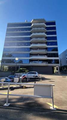
Approved plans and supporting documentation

Development must be carried out in accordance with the following approved plans and supporting documentation (stamped by Council), except where the conditions of this consent expressly require otherwise.

Plan No

Rev.

Plan Title

Drawn By

Dated

Architectural Plans

A-010

K

Cover Page/Site Plan

Collard Maxwell Architects

3 April 2025

A-100

F

Carpark Level 3A & 3B West Floor Plan

Collard Maxwell Architects

24 March 2025

A-101

H

Carpark Level 3A & 3B East Floor Plan

Collard Maxwell Architects

24 March 2025

A-102

F

Carpark Level 2A & 2B West Floor Plan

Collard Maxwell Architects

21 March 2025

A-103

G

Carpark Level 2A & 2B East Floor Plan

Collard Maxwell Architects

21 March 2025

A-104

E

Carpark Level 1A & 2B West Floor Plan

Collard Maxwell Architects

24 March 2025

A-105

G

Carpark Level 1A & 1B East Floor Plan

Collard Maxwell Architects

24 March 2025

A-106

G

Carpark Level Ground West

Collard Maxwell Architects

3 April 2025

A-107

I

Ground Floor Plan East

Collard Maxwell Architects

15 April 2025

A-108

F

Level 1 Floor Plan

Collard Maxwell Architects

1 April 2025

A-109

G

Level 2 Floor Plan

Collard Maxwell Architects

20 March 2025

A-112

F

Level 5 Floor Plan

Collard Maxwell Architects

20 March 2025

A-113

F

Level 6 Floor Plan

Collard Maxwell Architects

20 March 2025

A-150

D

Carpark Level 3A & 3B Full Plan

Collard Maxwell Architects

24 March 2025

A-151

D

Carpark Level 2A & 2B Full Plan

Collard Maxwell Architects

21 March 2025

A-152

D

Carpark Level 1A & 1B Full Plan

Collard Maxwell Architects

24 March 2025

A-153

E

Ground Floor Plan Full Plan

Collard Maxwell Architects

15 April 2025

A-200

G

North Elevation

Collard Maxwell Architects

10 April 2025

A-201

G

West Elevation/Section A-A & External Finishes

Collard Maxwell Architects

2 April 2025

A-202

F

East Elevation

Collard Maxwell Architects

2 April 2025

A-203

E

South Elevation

Collard Maxwell Architects

3 April 2025

A-300

E

Section B-B

Collard Maxwell Architects

2 April 2025

Concept Landscape Plan

L01

B

Landscape Plan

Terras Landscape Architects

14 March 2025

L02

B

Specifications 01

Terras Landscape Architects

14 March 2025

L03

B

Specifications 02

Terras Landscape Architects

14 March 2025

L04

B

Schedules 01

Terras Landscape Architects

14 March 2025

L05

B

Schedules 02

Terras Landscape Architects

14 March 2025


Document Title

Version No.

Prepared By.

Dated Title.

Statement of Environmental Effects

D

Interface Planning

May 2025

Civil Engineering Plans (Erosion and Sedimentation Control Plan and Driveway Plan)

B

Wallace Infrastructure Design Pty Ltd


March 2025

BCA Access Compliance Assessment Report

Rev.02

AED Group

April 2025

BCA Section J Compliance Report

4

Marine Building Services Engineers

April 2025

Traffic and Parking Assessment

D

TTPA – Transport and Traffic Planning Associates

April 2025

Bushfire Assessment Report

-

Sydney Bushfire Consultants

February 2025

Arboricultural Impact Assessment

Ver. 3

Arbor Express

March 2025

Waste Management Plan

-

Collard Architects Pty Ltd

-

Clause 4.6 Written Variation

B

Interface Planning

April 2025


In the event of any inconsistency between the approved plans and a condition of this consent, the condition prevails.


Reason: To ensure all parties are aware of the approved plans and supporting documentation that applies to the development.


2.         A.2 - Design amendments

Before the issue of a construction certificate, the certifier must ensure the approved construction certificate plans (and specifications) detail the following required amendments to the approved plans and supporting documentation stamped by Council.


a)   Amended Architectural plans are to be submitted requiring the deletion of the proposed vehicle access via Sirius Road to the lower level of the carpark. The plans must confirm that trees 1-5, 8, 9,11-15, 18-30 are retained and protected for the life of development.

b)   All plans to be amended to include the retention of trees 1-5 and 8-9

c)   As the current proposed tree planting of 6 x Cyathea cooperi as outlined on the Landscape Plan Drawing No. 15772.5 DA L01 Landscape Plan B by Terras Landscape Architects dated 17.03.25 fails to achieve tree canopy targets as outlined within LCCDCP Part J section 3.5 & 3.6, and fails to meet the objectives and provisions outlined under Part S - Environmental Sustainability Section 3.3, the 6 x Cyathea cooperi trees must be replaced by a minimum of 2 x 100Ltr Large (L) and 4 x 100Ltr Medium sized trees selected from within species listed in Appendix 4 LCCDCP part J Amendment 2023

d)   Within amended plans, provide one (1) EV charging Space for electric vehicle use in accordance with relevant policies.

Reason: To require minor amendments to the approved plans and supporting documentation following assessment of the development.


3.         A.3 - Payment of security deposits

Before the commencement of any works on the site, or the issue of a construction certificate, the applicant must make the following payment to Council and provide written evidence of these payments to the Certifier:


Security deposit

Amount

Infrastructure damage bond

$5000.00


A $5000.00 cash bond or bank guarantee shall be lodged with Council to cover the satisfactory construction of the above requirements.


The payments will be used for the cost of:

·    making good any damage caused to any council property (including street trees) as a consequence of carrying out the works to which the consent relates.

·    completing any public work such as roadwork, kerbing and guttering, footway construction, stormwater drainage and environmental controls, required in connection with this consent.


Reason: To ensure any damage to public infrastructure is rectified and public works can be completed.


4.         A.4 - Payment of building and construction industry long service levy

Before the issue of a construction certificate, the applicant is to ensure that the person liable pays the long service levy of $12,156.00 as calculated at the date of this consent to the Long Service Corporation or Council under section 34 of the Building and Construction Industry Long Service Payments Act 1986 and provides proof of this payment to the principal certifier.


Reason: To ensure the long service levy is paid.
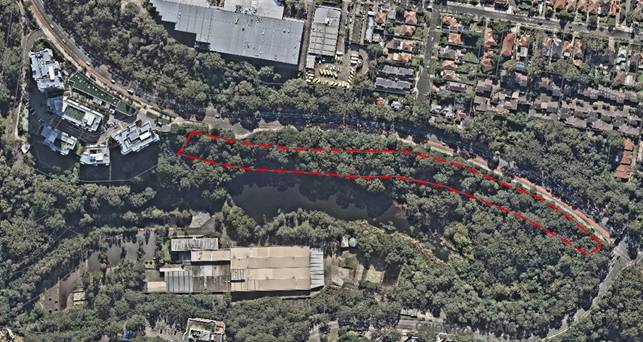
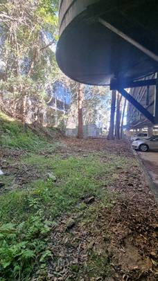
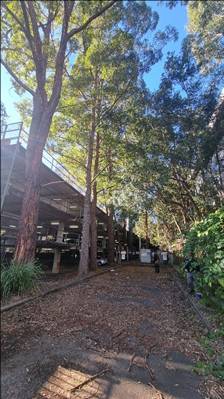
 

5.         A.7.L - Tree preservation and approved landscaping works

The protection of trees in Lane Cove is regulated under the State Environmental Planning Policy (Biodiversity and Conservation) 2021 (SEPP) parts 2.2 and 2.3 which prohibits the clearing of vegetation without the authority conferred by a permit granted by Council. Clearing under the SEPP is defined as:


(a)  cut down, fell, uproot, kill, poison, ringbark, burn or otherwise destroy the vegetation, or

(b)  lop or otherwise remove a substantial part of the vegetation.


The clearing of trees or vegetation protected by the regulation is an offence against the Environmental Planning and Assessment Act 1979 (NSW).


The maximum penalty that may be imposed in respect to any such offence is $1,100,000 per individual and $5,500,000 per corporation.


The following trees shall be retained:


Tree No.

Species

Location

Dimension (meters)

1

Eucalyptus microcorys

Subject site adjacent childcare centre and existing carpark

18 x 8m

2

Eucalyptus microcorys

Subject site

Subject site adjacent childcare centre and existing carpark

20 x 12m

3

Eucalyptus microcorys

Subject site between existing carpark and service roadway

20 x 8m

4

Eucalyptus microcorys

Subject site between existing carpark and service roadway

20 x 9m

5

Eucalyptus microcorys

Subject site between existing carpark and service roadway

20 x 7m

8

Eucalyptus microcorys

Subject site between existing carpark and service roadway

29 x 10m

9

Eucalyptus microcorys

Subject site adjacent electrical substation

20 x 12m

11

Glochidion ferdinandi

Neighbouring Site

10 x 8m

12

Eucalyptus saligna

Neighbouring Site

11 x 5m

13

Glochidion ferdinandi

Neighbouring Site

12 x 7m

14

Glochidion ferdinandi

Neighbouring Site

14 x 6m

15

Glochidion ferdinandi

Neighbouring Site

14 x 6m

18

Casuarina cunninghamiana

Neighbouring Site

22 x 8m

19

Casuarina cunninghamiana

Neighbouring Site

22 x 7m

20

Glochidion ferdinandi

Neighbouring Site

12 x 6m

21

Glochidion ferdinandi

Neighbouring Site

17 x 8m

22

Glochidion ferdinandi

Neighbouring Site

13 x 6m

23

Glochidion ferdinandi

Neighbouring Site

12 x 5m

24

Glochidion ferdinandi

Neighbouring Site

12 x 5m

25

Glochidion ferdinandi

Neighbouring Site

15 x 6m

26

Glochidion ferdinandi

Neighbouring Site

14 x 6m

27

Eucalyptus saligna

Neighbouring Site

24 x 10m

28

Glochidion ferdinandi

Neighbouring Site

12 x 6m

29

Glochidion ferdinandi

Neighbouring Site

9 x 8m

30

Glochidion ferdinandi

Neighbouring Site

9 x 8m


This consent gives approval for the removal of the following trees:


Tree No.

Species

Location

Dimension (meters)

6

Casuarina cunninghamiana

Subject site between existing carpark and service roadway

15 x 5m

7

Casuarina cunninghamiana

Subject site between existing carpark and service roadway

18 x 6m

10

Pittosporum undulatum

Subject Site

within deep soil zone between existing carpark and boundary

8 x 5m

16

Glochidion ferdinandi

Subject Site

within deep soil zone between existing carpark and boundary

13 x 8m

17

Pittosporum undulatum

Subject Site

within deep soil zone between existing carpark and boundary

6 x 4m


This consent gives approval to carry out the following works in Tree Protection Zones:


Tree No.

Species

Location

Permitted works in TPZ

5

Eucalyptus microcorys

Subject site between existing carpark and service roadway

Removal of tree 6 and 7

8

Eucalyptus microcorys

Subject site between existing carpark and service roadway

Removal of tree 6 and 7


No tree pruning is permitted as part of this consent unless otherwise conditioned. Any tree pruning requires a formal Tree Works Authority Application to be made to Council.

Reason: To ensure the protection of trees to be retained and to confirm trees removed for pruning/removal.


6.         A.9.T - Works on Council land

Separate application shall be made to Council’s Urban and Services Division if there is any associated works on Council property. Written approval is to be obtained prior to the start of any works on Council property.


Where the applicant requires the use of construction plant on the public road reservation, an “Application for Standing Plant Permit” shall be made to Council. Applications shall be submitted and approved prior to the start of any related works. Note: allow 2 working days for approval


Reason: To manage impacts to Council’s assets.


7.         A10 – Special condition – Prepurchase of Replacement Trees
Prior to the issue of a construction certificate, the applicant is to provide receipt of pre purchase for all landscape trees equal to or greater than 100Ltr pot size from a registered nursery. Purchased trees must be of the nominated pot sizes indicated within the planting schedule shown within the landscape plans approved by Council prior to Construction Certificate. The receipt is to be provided to Council’s Landscape and Tree department. Purchased trees are to be grown in accordance with specifications outlined within AS2303:2018 Tree Stock for Landscape Use.

Reason: To ensure replacement trees are at appropriate size upon completion of the development.

8.         A10 – Special condition – Tree Protection Plan
Prior to the issue of a construction certificate, a site-specific Tree Protection Plan (TPP) must be prepared by a minimum Australian Qualification Framework (AQF) Level 5 arborist and submitted to Council’s Principal Arborist for approval. The plan must be written and conform to all Arboricultural plan / report requirements outlined within Appendix 5 of the Lane Cove Development Control Plan Part J 2023 amendment and be in accordance with the guidance and principles provided within Australian Standard AS 4970:2025 - Protection of trees on development sites. The TPP must include all trees listed to be retained in condition A.7.L Tree preservation and approved landscaping works. The approved TPP must be kept on site until the release of an occupation certificate.
Reason: Tree Protection Requirements


9.         A.12 – Construction Certificate

The submission of a Construction Certificate and its issue by Council or Principal Certifier PRIOR TO CONSTRUCTION WORK commencing.


Reason: To ensures the detailed construction plans and specifications comply with the requirements of the Building Code of Australia (BCA) and any relevant Australian Standard.


10.       A.26 – Work Zone

A Construction Traffic Management Plan and an application for a Work Zone adjacent the development shall be submitted to Lane Cove Council for determination, prior to any works that require construction vehicle and machinery movements to and from the site. If the development has access to a State Road, the Construction Management Plan and Work Zone need to be referred to RMS for approval. The approval of the Traffic Construction Management Plan and application for a Work Zone by Council’s Traffic Section must be submitted to the Principal Certifying Authority prior to the issue of the relevant Construction Certificate.  


Reason:  To provide safer working environment and minimize interruption to pedestrians and Motorists


PART B – PRIOR TO DEMOLITION WORKS


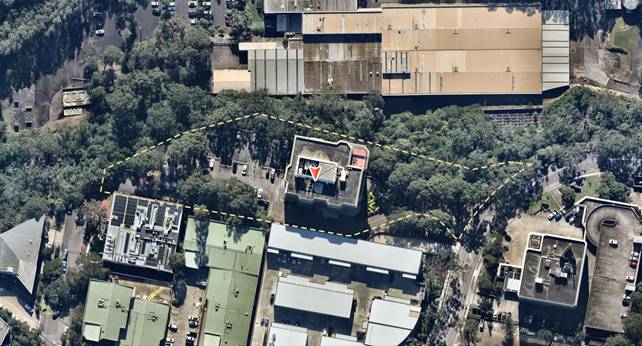
11.       B.1.T   Demolition Traffic Management Plan

As a result of the site constraints, limited vehicle access and parking, a demolition traffic management plan (DTMP) and report shall be prepared by a Transport for NSW accredited person and submitted to and approved by Council prior to commencing any demolition work.

The DTMP must:-

a)         Make provision for all construction materials to be stored on site, at all times.

b)         Specify construction truck routes and truck rates. Nominated truck routes are to be distributed over the surrounding road network where possible.

c)         Provide for the movement of trucks to and from the site, and deliveries to the site. Temporary truck standing/ queuing locations in a public roadway/ domain in the vicinity of the site is not permitted unless a Works Zone is approved by Council.

d)         Include a Traffic Control Plan prepared by an RMS accredited ticket holder for any activities involving the management of vehicle and pedestrian traffic.

e)         Specify that a minimum seven (7) days notification must be provided to adjoining property owners prior to the implementation of any temporary traffic control measures.

f)          Include a site plan showing the location of any site sheds, location of requested Work Zones, anticipated use of cranes, structures proposed on the footpath areas (hoardings, scaffolding or temporary shoring) and extent of tree protection zones around Council Street trees.

g)         Take into consideration the combined construction activities of other development in the surrounding area. To this end, the consultant preparing the DTMP must engage and consult with developers undertaking major development works within a 250m radius of the subject site to ensure that appropriate measures are in place to prevent the combined impact of construction activities. These communications must be documented and submitted to Council prior to work commencing on site.

h)         Be prepared in accordance with relevant sections of Australian Standard 1742 – “Manual of Uniform Traffic Control Devices”, RMS’s Manual – “Traffic Control at Work Sites”.


Reason: To ensure public safety and minimise any impacts to the adjoining pedestrian and vehicular traffic systems.


12.       B.2.E - Asbestos removal, handling and disposal

The removal, handling and disposal of asbestos from building sites shall be carried out in accordance with the requirements of the Occupational Health and Safety Act and the Regulations. Details of the method of removal in accordance with this condition is to be submitted to the Principal Certifier and Council’s Environmental Health Section, prior to commencing any demolition works.


Reason: To ensure worker and public health and safety.


13.       B.3.EH - Compliance with demolition standard

Demolition of buildings and structures must comply with Australian Standard AS 2601—2001: The Demolition of Structures.


Reason: Prescribed condition under the EP&A Regulation 2021.


14.       B.4.EH - Demolition work plan The name, address, contact details and licence number of the Demolisher / Asbestos Removal Contractor.

-           Details of hazardous materials (including asbestos).

-           Method/s of demolition (including removal of any asbestos).

-           Measures and processes to be implemented to ensure the health & safety of workers and community.

-           Measures to be implemented to minimise any airborne dust and asbestos.

-           Methods and location of disposal of any hazardous materials (including asbestos).

-           Other relevant details, measures and requirements to be implemented.

-           Details of re-use, recycling and disposal of waste materials.

-           Date the demolition works will commence.


Reason: To ensure health and safety.


15.       B.5.EH Construction environmental management plan (larger/more complex developments)

Prior to the commencement of any demolition and remedial works, a construction environmental management plan (CEMP) must be prepared for the site and submitted to Council for written approval prior to the commencement of work. The CEMP must consider all potential environmental impacts from the approved works including but not limited to sedimentation control, contamination containment, stockpiles, noise and vibration, odours and dust emissions. All works must be undertaken onsite in accordance with the approved CEMP.


Reason: To ensure health and safety.


16.       B.13.L - Project Arborist

Prior to the commencement of any works including demolition, a project arborist of minimum Australian Qualitative Framework (AQF) Level 5 qualification is to be appointed to oversee/monitor any retained tree/s condition and tree protection compliance during the construction process. A letter of engagement must be provided to Council prior to issue of a construction certificate for certification. Compliance certificates must be available upon request, submitted to the Principal Certifier within five days of site attendance and must be available to council immediately upon request prior to the issue of an occupation certificate; failure to produce the latest certificate will be considered a breach of conditions.  Each compliance certificate must contain photographic evidence to confirm site attendance.

The project Arborist shall:


1.   Clearly identify and tag trees (where appropriate) which are to be removed and trees which are to be retained as part of this consent.

2.   Certify all tree protection measures listed within the approved tree protection plan have been installed prior to works commencing.

3.   Prepare a pre-construction arboricultural report on the health of the trees to be retained and protected following a site visit with Council’s Principal Arborist.  The report shall be agreed upon by both parties and shall include photographs of each tree and any existing damage, defects or areas of concern well represented.

4.   Oversee any tree removal works, excavation works, resurfacing works within the TPZ/NRZ/SRZ of retained trees.

5.   Oversee any stormwater works within the TPZ/NRZ/SRZ of retained trees.

6.   Oversee any new retaining wall works within the TPZ/NRZ/SRZ of retained trees.

7.   Prepare a post construction Arboricultural report regarding the health, viability, and condition of the retained trees. The report must also recommend remedial advice for trees post construction to mitigate and long-term construction impacts.


Before the issue of an occupation certificate, the principal certifier is to provide a copy of the post-construction arboricultural report to Council’s Principal Arborist (where Council is not the principal certifier) and to the relevant adjoining property owner(s) where trees are located within 5m of a boundary line.


Reason: To ensure trees to be protected on the site.


17.       B.14A  -  Special Condition - Tree Protection Measures Fencing/Trunk Protection

The following tree protection measures must be in place prior to demolition works and certified by the project arborist.


1.   Tree Protection Fencing must be in accordance with the approved tree protection plan.

ii)      

2.   Where fencing has been specified, the fencing must consist of a 1.8 m high chain mesh fence held in place with concrete block footings and fastened together. An example of fencing is shown under figure 4 on page 18 of the Australian Standard 4970-2025 The Protection of trees on development sites.

iii)    

3.   The fenced area shall not be used for the storage of building materials, machinery, site sheds, or for advertising and the soil levels within the fenced area shall remain undisturbed.

iv)    

4.   Where Trunk protection has been specified the trunks of the trees must be protected during the construction period by a trunk guard that consists of the following:

v)     

5.   Timber Planks (50mmx100mm or similar) shall be placed at 100mm intervals and must be fixed by wire ties or strapping to a height of 2m.

vi)    

6.   Hessian cloth is to be placed between the trunk and the planks to minimise damage. The timber planks are not to be fixed directly to the tree in any way.

vii)   

7.   An example of suitable trunk protection can be found on page 20 within the Australian Standard 4970-2025 The Protection of trees on development sites.

viii)  

8.   A waterproof sign must be placed on every second panel stating, ‘NO ENTRY TREE PROTECTION AREA – this fence and sign are not to be removed or relocated for the work duration.’  Minimum size of the sign is to be A3 portrait with NO ENTRY TREE PROTECTION ZONE in capital Arial Font size 100, and the rest of the text in Arial font size 65.

ix)    

9.   Tree Protection fencing/trunk protection and signage must be erected Prior to Demolition including site preparation and remain in place for the duration of the construction work.

x)     

10. Movement of Tree Protection Fencing must be overseen and approved by the Project Arborist. 


Reason: To protect the natural environment


PART C - BEFORE THE ISSUE OF A CONSTRUCTION CERTIFICATE


18.       C.1 - Construction site management plan

Prior to any demolition works and before the issue of a construction certificate, the applicant must ensure a construction site management plan is prepared before it is provided to and approved by the certifier. The plan must include the following matters:

·        Before commencement of any works, safety barrier or temporary fencing is to be provided covering work area. This fence is for the safety of pedestrians on the public footpath.

·        Location and materials for protective fencing and hoardings to the perimeter on the site.

·        Provisions for public safety.

·        Pedestrian access, including disabled and pram access, is to be maintained throughout the course of the construction as per AS-1742.3, ’Part 3 - Traffic control devices for works on roads’.

·        Pedestrian and vehicular site access points and construction activity zones.

·        Location of site storage areas and sheds.

·        Equipment used to carry out all work.

·        A garbage container with a tight-fitting lid.

·        A Construction Traffic Management Plan shall be prepared by a Transport for NSW accredited person and approved by Council’s Traffic Department prior to commencing of any works.


The applicant must ensure a copy of the approved construction site management plan is kept on-site at all times during construction.


Council Approvals

1.         Where hoarding is required to be provided along the street frontage, a Hoarding Application is to be submitted to Council for approval.

2.         Any construction plant on the public road reservation requires an approved “Application for standing plant permit”.


Reason: To require details of measures that will protect the public, and the surrounding environment, during site works and construction.


19.       C.3 - Waste management plan (WMP)

Before the issue of a construction certificate, the applicant is to ensure that a waste management plan is prepared in accordance with the EPA’s Waste Classification Guidelines and the following requirements before it is provided to and approved by the certifier:

i)          Council’s Development Control Plan (Part Q: Waste Management and Minimisation).

j)          Where sites adjoin bushland (private or public):

-        the WMP shall detail measures to mitigate any rubbish or foreign materials from entering the bushland.

-        Access through parks, reserves and bushland to the site is not permitted.

-        Council’s Coordinator of Bushland must be notified of any accidental or intentional dumping of material in the bushland area.

k)         details the following:

-        the contact details of the person(s) removing the waste

-        an estimate of the waste (type and quantity) and whether the waste is expected to be reused, recycled or go to landfill

-        the disposal and destination of all waste material spoil and excavated material


The applicant must ensure the waste management plan is referred to in the construction site management plan and kept on-site at all times during construction.


Reason: To ensure resource recovery is promoted and local amenity protected during construction.


20.       C.4 - Utilities and services

Before the issue of the relevant construction certificate, the applicant must submit the following written evidence of service provider requirements to the certifier:

a)         a letter of consent from the electricity supplier demonstrating that satisfactory arrangements can be made for the installation and supply of electricity.

b)         a response from Sydney Water as to whether the plans proposed to accompany the application for a construction certificate would affect any Sydney Water infrastructure, and whether further requirements need to be met.

c)         other relevant utilities or services - that the development as proposed to be carried out is satisfactory to those other service providers, or if it is not, what changes are required to make the development satisfactory to them.


Reason: To ensure relevant utility and service providers requirements are provided to the certifier.


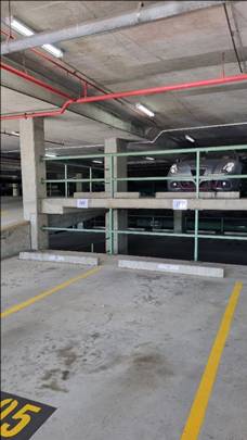
21.       C.11.T - Basement car park safety and functionality

Prior to the issue of the relevant construction certificate, a Traffic Report demonstrating the safety and functionality of the basement car park, including details of the proposed signalised system is to be submitted to and approved by Council’s Traffic Department. Certification of the internal traffic signal system that it complies with relevant standards and is safe and functional is to be provided by an independent Traffic Consultant.


Reason: To ensure safety and functionality of the basement car park.


22.       C.15.EH - Evidence of disposal of all waste, spoil and excavation material

As soon as practicable after demolition is completed, documentary evidence detailing the destination of waste materials is to be submitted to the Principal Certifier.


Reason: To ensure waste is managed appropriately.


23.       C.16.EH - Construction waste management plan

Prior to the commencement of any works on the subject site, a construction waste management plan (CWMP) must be prepared for the development by a suitably qualified person in consultation with the Council and be submitted for approval.


The CWMP must address, but not be limited to, the following matters:

·        Recycling of demolition materials including concrete.

·        Removal of hazardous materials and disposal at an approved waste disposal facility in accordance with the requirements of the relevant legislation, codes, standards and guidelines, prior to the commencement of any building works.

·        Details of methods to be used to prevent spill, escape of any dust, waste or spoil from the vehicles or trailers used to transport waste or excavation spoil from the site.

·        Details demonstrating compliance with the relevant legislative requirements, associated with the removal of hazardous waste (if present), particularly the method of containment and control of emission of fibres to the air, must be submitted to the satisfaction of the Certifying Authority prior to the removal of any hazardous materials.

·        Provide details of truck routes and make appropriate notifications as required to comply with current regulations. The Applicant must submit a copy of the CWMP for review to Council prior to the commencement of work.


Reason: To promote resource recovery and environmental protection.


24.       C.23.B - Sydney Water requirements

The approved plans must be submitted to Sydney Water online approval portal “Sydney Water Tap In” for approval.


Reason: To comply Sydney Water requirements.


25.       C.24.E - Structural engineer’s details

The Construction Certificate plans and specifications must include detailed professional structural engineering plans and/or specifications for the following:

·        underpinning;

·        retaining walls;

·        footings;

·        reinforced concrete work;

·        structural steelwork;

·        upper level floor framing;


and where relevant in accordance with any recommendations contained in an approved geotechnical report.


Reason: To ensure structural adequacy.


PART D - BEFORE THE COMMENCEMENT OF BUILDING WORK


26.       D.1 - Erosion and sediment controls in place

Before the commencement of any site or building work, the principal certifier must be satisfied the erosion and sediment controls in the erosion and sediment control plan, (as approved by the principal certifier) are in place until the site is rectified (at least 70% ground cover is achieved over any bare ground on site).


Reason: To ensure runoff and site debris do not impact local stormwater systems and waterways.


27.       D.2 - Tree protection measures

Before the commencement of any site or building work, the principal certifier must ensure the measures for tree protection detailed in the construction site management plan are in place.


Reason: To protect and retain trees.


28.       D.3 - Signs on site

A sign must be erected in a prominent position on any site on which building work or demolition work is being carried out:

a)         showing the name, address and telephone number of the principal certifier for the work; and

b)         showing the name of the principal contractor (if any) for any building work and a telephone number on which that person may be contacted outside working hours; and

c)         stating that unauthorised entry to the work site is prohibited.

Any such sign is to be maintained while any demolition or building work is being carried out but must be removed when these works have been completed.


Note: This does not apply in relation to building work, or demolition work, that is carried out inside an existing building that does not affect the external walls of the building.


Reason: Prescribed condition under section 70 of the EP&A Regulation 2021.


PART E - WHILE BUILDING WORK IS BEING CARRIED OUT


29.       E.1 - Hours of work

The principal certifier must ensure that building work, demolition or vegetation removal is only carried out between:

Monday to Friday (inclusive)                   7.00am to 5.30pm

Saturday                                                  7.00am to 4.00pm


With NO high noise generating activities, to be undertaken after 12 Noon on Saturday.


A Notice/Sign showing permitted working hours and types of work permitted during those hours, including the applicant’s phone number, project manager or site foreman, shall be displayed at the front of the site.


The principal certifier must ensure building work, demolition or vegetation removal is not carried out on Sundays and public holidays, except where there is an emergency.


Reason: To protect the amenity of the surrounding area.


30.       E.2 - Compliance with the Building Code of Australia

Building work must be carried out in accordance with the requirements of the Building Code of Australia.


Reason: Prescribed condition under section 69 of the EP&A 2021.


31.       E.2.1 - Special condition – Stockpiling of Materials


No stockpiling of materials, building equipment or additional activities listed in section 4.2 of AS4970-2025 The Protection of trees on development sites is to occur within designated tree protection areas or on the Council Owned Nature Strip. All building materials must be delivered and stored within the subject site.


Reason: To mitigate damage to Council land


32.       E.2.2 – Special condition - Demolition of hardstand areas within the Tree Protection Zone / Notional Root Zone or Structural Root Zone of protected trees


1.         The demolition of the existing hardstand or structures within the Tree Protection Zone /Notional Root Zone/ Structural Root Zone of trees 1-5 and 8 must be overseen by the project arborist.


2.         The demolition of hardstand elements within the Tree Protection Zone /Notional Root Zone/ Structural Root Zone of retained trees must be undertaken via the use of handheld pneumatic breaker tools (ie Jackhammer) and removed by hand under the supervision of the project arborist. No machinery within this area is to be used below existing grade.


3.         Roots <40mm diameter that conflict with approved cut lines must be documented by the Project arborist and pruned with a sharp implement.


4.         Exposed roots shall be protected in accordance with section 4.5.4 of AS4970-2025 The protection of trees on development sites.


Reason: To protect the root system of retained tree


33.       E.2.3 – Special condition – Excavation within Tree Protection/Notional Root Zone and Structural Root Zones

Any excavation within a Tree Protection Zone / Notional Root Zone or Structural Root Zone of Trees 1-5 and 8 must be done under the supervision of the project arborist.

1.         Any pier locations for suspended concrete slabs must be flexible, with no roots greater than 40mm diameter to be pruned.


2.         A 200mm buffer must be allowed for roots greater than 40mm diameter at allow for future growth.


3.         Tree roots less than 40mm that conflict with pier locations must be severed cleanly with a sharp implement and documented within a compliance certificate by the Project Arborist.


4.         Exposed roots must be treated and protected in accordance with provisions outlined in section 4.5.4 of AS4970-2025.


5.         Where pier / post holes or concrete footings are within a TPZ these must be lined with a heavy-duty polyethylene film (builders Plastic) prior to pouring to prevent leaching.

Reason – To protect the root system of retained trees


34.       E.2.4 - Special Condition – Excavation for stormwater services

Excavation and installation of stormwater services within the Tree Protection Zone / Notional Root Zone / Structural Root Zone of retained trees must be overseen by the project arborist.


1.         Excavation is to be undertaken using non-destructive methods (Hand tools, Hydrovac, Directional Drilling).


2.         No roots greater than 40mm diameter are to be damaged / severed as part of works.


3.         Roots less than 40mm diameter than conflict with services must be documented by the project arborist within a compliance certificate and pruned using a sharp implement.


4.         Service location must be flexible, with a 200mm diameter buffer allowed to roots greater than 40mm diameter to allowed for future growth.


5.         Exposed roots must be treated and protected in accordance with provisions outlined within section 4.5.4 of AS4970-2025 The protection of trees on Development Sites.


Reason: To minimise damage to the root system of protected trees


35.       E.2.5 – Special Condition – Installation of retaining walls within the TPZ of retained trees

The installation of any retaining walls within the Tree Protection Zone / Notional Root Zone/Structural Root Zone of retained trees:

1.         Must be done so using an isolated pier and beam method or use existing footings under the supervision of the project arborist.


2.         No roots greater than 40mm diameter are to be severed to facilitate the installation of the piers. A 200mm buffer must be given to roots greater than 40mm diameter.


3.         Roots >40mm diameter must be incorporated into the wall.


4.         Roots >40mm diameter must be bridged using a lentil.


5.         Roots less than 40mm diameter that conflict with the location of piers must be documented by the Project arborist, pruned with a sharp implement and recorded for compliance.


6.         Exposed roots shall be protected in accordance with section 4.5.4 of AS4970-2025 The protection of trees on development sites.


7.         The excavated area adjoining the wall must be backfilled using a coarse (>20mm) aggregate and site soil. An Ag line must be installed at the base of the wall to ensure adequate drainage.


Reason: To mitigate damage to retained trees


36.       E.3 - Procedure for critical stage inspections

While building work is being carried out, any such work must not continue after each critical stage inspection unless the principal certifier is satisfied the work may proceed in accordance with this consent and the relevant construction certificate.


Reason: To require approval to proceed with building work following each critical stage inspection.


37.       E.4 - Implementation of the site management plans

While vegetation removal, demolition and/or building work is being carried out, the applicant must ensure the measures required by the approved construction site management plan and the erosion and sediment control plan are implemented at all times.


The applicant must ensure a copy of these approved plans is kept on site at all times and made available to Council officers upon request.


Reason: To ensure the required site management measures are implemented during construction.


38.       E.6 - Surveys by a registered surveyor

While building work is being carried out, a registered surveyor is to measure and mark the positions of the following and provide them to the principal certifier —

a)         All footings/ foundations

b)         At other stages of construction – any marks that are required by the principal certifier.


Reason: To ensure buildings are sited and positioned in the approved location


39.       E.7 - Construction noise

While building work is being carried out where no noise and vibration management plan is approved under this consent, the applicant is to ensure that any noise caused by demolition, vegetation removal or works does not exceed an LAeq (15 min) of 5dB(A) above background noise, when measured at any lot boundary of the property where these works are being carried out.


Reason:  To protect the amenity of the neighbourhood.


40.       E.8 - Tree protection

While site or building work is being carried out, the applicant must maintain all required tree protection measures in good condition in accordance with:

1.   The relevant conditions of this consent

xi)    

2.   The Construction Site Management Plan (CSMP) required under this consent (where applicable)

xii)   

3.   The relevant requirements of AS 4970-2025 Protection of trees on development sites

xiii)  

4.   Any arborist’s report approved under this consent (where applicable)

xiv)  

5.   This includes maintaining adequate soil grades and ensuring all machinery, builders refuse, spoil and materials remain outside tree protection zones.

xv)   

6.   Specific conditions within this consent supersede any conflicting recommendations within an applicable CSMP or Arborist report.

Reason: To protect trees during construction.


41.       E.10 - Shoring and adequacy of adjoining property

If the development involves any excavation that extends below the level of the base of the footings of a building, structure or work on adjoining land (including any structure or work within a road or rail corridor), the person having the benefit of the development consent must, at the person’s own expense —


l)          Protect and support the building, structure or work from possible damage from the excavation, and

m)        Where necessary, underpin the building, structure or work to prevent any such damage.


This condition does not apply if the person having the benefit of the development consent owns the adjoining land or the owner of the adjoining land has given consent in writing to that condition not applying.


Reason: Prescribed condition - EP&A Regulation clause 98E


42.       E.18.B - No obstruction of public way

The public way and Council verge must not be obstructed by any materials, vehicles, refuse, skips or the like, under any circumstances. Non-compliance with this requirement will result in the issue of a notice by Council to stop all work on site.


Reason: To ensure public safety.


PART F - BEFORE THE ISSUE OF AN OCCUPATION CERTIFICATE


43.       F.1 - Works-as-executed plans and any other documentary evidence

Before the issue of the relevant occupation certificate, the applicant must submit, to the satisfaction of the principal certifier, works-as-executed plans, any compliance certificates and any other evidence confirming the following completed works:

(a)     The following matters that Council requires to be documented:


·        Certification from a suitably licensed contractor that all fit out works have been constructed satisfying relevant Australian standards.


The principal certifier must provide a copy of the plans to Council with the occupation certificate.


Reason: To confirm that the proposed works have been constructed satisfactorily as per approved plans.


44.       F.1.1 - Special condition – Post Construction Dilapidation report: Trees to be Retained


Before the issue of an occupation certificate, the principal certifier must review the post construction Arboricultural report prepared by the appointed Project Arborist and be satisfied that all retained trees have been maintained in a healthy, viable condition and any replacement planting has been undertaken.


The principal certifier is to provide a copy of the post construction Arboricultural report to Council (where Council is not the principal certifier) and to the relevant adjoining property owner(s).


Reason: To ensure retained trees have been protected during construction.


45.       F.5 - Repair of infrastructure

Before the issue of an occupation certificate, the applicant must ensure any public infrastructure damaged as a result of the carrying out of building works (including damage caused by, but not limited to, delivery vehicles, waste collection, contractors, sub-contractors, concreting vehicles) is fully repaired to the written satisfaction of Council, and at no cost to Council.


Note: If the council is not satisfied, the whole or part of the security/bond submitted will be used to cover the rectification work.


Reason: To ensure any damage to public infrastructure is rectified.


46.       F.6 - Removal of waste upon completion

Before the issue of an occupation certificate, the principal certifier must ensure all refuse, spoil and material unsuitable for use on the site is removed from the site and disposed of in accordance with the waste management plan. Written evidence of the removal must be supplied to the satisfaction of the principal certifier.


Before the issue of a partial occupation certificate, the applicant must ensure the temporary storage of any waste is carried out in accordance with the approved waste management plan to the principal certifier’s satisfaction.


Reason: To ensure waste material is appropriately disposed of or satisfactorily stored.


PART H - OCCUPATION AND ONGOING USE


47.       H.1 - Release of securities / bonds

When Council receives an occupation certificate from the principal certifier, the applicant may lodge an application to release the securities held in accordance with Condition (4). Council may use part, or all of the securities held to complete the works to its satisfaction if the works do not meet Council’s requirements.


Reason: To allow release of securities and authorise Council to use the security deposit to complete works to its satisfaction.


48.       H.2 - Annual fire safety certificate

During occupation and ongoing use of the building, the applicant must provide an annual fire safety statement to Council and the Commissioner of Fire and Rescue NSW in accordance with clause 177 of the EP&A Regulation.


Reason: To satisfy Council’s Engineering requirements to ensure annual checks on fire safety measures.


49.       H.2.1 - Special Conditions – Fire Safety

·    Illuminated exit signage and directional exit signs are to be installed throughout the carparking floor levels to clearly identify and direct building occupants leading to the designated fire-isolated exit staircases to ensure compliance with the requirements of Australian Standard AS/NZS2293.1-2018.

·    The existing fire exit doors located throughout the carparking floor levels are to be upgraded and installed with provision of new single hand downward action lever type door hardware in accordance with D3D26 of the National Construction Code.


Reason: To satisfy Council’s Engineering requirements to ensure annual checks on fire safety measures.


50.       H.4 - Maintenance of stormwater system

During occupation and ongoing use of the building, the applicant must ensure all wastewater and stormwater treatment devices (including drainage systems and pollution control pit) are regularly maintained to remain effective. This is to be done in accordance with any positive covenant, if applicable.


            Reason: To satisfy Council’s Engineering requirements and ensure the protection of sewerage and stormwater systems.


Mark Brisby

Director - Planning and Sustainability

Planning and Sustainability Division


ATTACHMENTS:

There are no supporting documents for this report.


Lane Cove Local Planning Panel Meeting 09 July 2025

s8.2 review of s4.55 modification at 21 - 41 Canberra Avenue St Leonards


Item No:         LPP13/25

Subject:          s8.2 review of s4.55 modification at 21 - 41 Canberra Avenue St Leonards    

Record No:    DA21/99-01 - 38016/25

Division:         Planning and Sustainability Division

Author(s):      Christopher Shortt 


Property:

21- 41 Canberra Avenue and 18-32 Holdsworth Avenue, St Leonards South.

DA No:

DA99/2021

Date Lodged:

19 May 2025

Cost of Work:

No additional cost.

Owner:

The Trustee for Silver Pond Unit Trust

Applicant:

Mecone Group Pty Ltd


Description of the proposal to appear on determination

Demolition of existing structures and construction of five (5) residential flat buildings (ranging from 6 to 10-storeys) comprising a total of 319 apartments and basement parking for 372 vehicles.

s8.2(1) review

s8.2 review of s4.55 amendment to condition E.1 (Hours of Work).

Zone

R4 High Density Residential

Is the proposal permissible within the zone

Yes

Stop the Clock used

No

Notification

Notified as per Council’s policy 27 submissions received.


REASON FOR REFERRAL


The proposal is referred to the Lane Cove Local Planning Panel as more than 10 public submissions were received as a result of the notification period.  The proposal is therefore considered to be a contentious application.


EXECUTIVE SUMMARY


·    On 11 April 2025 Council issued a refusal for modification (Mod 5) of DA99/2021 which sought consent to amend condition E.1 for Construction Hours on Saturdays. This was refused under delegation.

·    The s8.2 review addresses the reasons for refusal in that decision, and is submitted for The Panel’s consideration.

·                      

SITE


The subject site is known as 21 - 41 Canberra Avenue and 18 - 32 Holdsworth Avenue, St Leonards with a total site area of 12,653sqm. The site is known as Area 7, 8, 9, 10 and 11 within the St Leonards South Precinct. The site is located in the south-eastern part of the St Leonards South Precinct. Demolition and construction works have commenced on site in accordance with Stage 1 of the development, as identified on the approved plans.


SITE APPLICATION HISTORY


DA99/2021

The Sydney North Planning Panel at its meeting of 2 March 2022 determined to approve Development Application DA99/2021 for the demolition of existing structures and construction of five (5) residential flat buildings (ranging from 6 to 10-storeys) comprising a total of 330 apartments and basement parking for 372 vehicles.

Section 4.55 of DA99/2021

(Mod 1)

Approval was granted under Council delegation on 13 September 2022 for modifications including minor structural amendments and compliance with conditions of consent.

Section 4.55 of DA99/2021              (Mod 2)

Approval was granted under Council delegation on 2 February 2023 for the demolition of existing structures and construction of five (5) residential flat buildings (ranging from 6 to 10-storeys) comprising a total of 323 apartments and basement parking for 372 vehicles.

Section 4.55 of DA99/2021

(Mod 3)

Approval was granted under Council delegation on 19 June 2023 for the demolition of existing structures and construction of five (5) residential flat buildings (ranging from 6 to 10-storeys) comprising a total of 323 apartments and basement parking for 372 vehicles.

This application sought to amend the Water NSW condition.

Section 4.55 of DA99/2021               (Mod 4)

Approval was granted under Council delegation on 15 January 2024 to modify the approved development which largely pertains to building 7 and 8 modifications.

Section 4.55 of DA99/2021

(Mod 5)

A s4.55 modification to amend condition E.1 (Hours of Work) was refused under delegation on 11 April 2025.


DETERMINATION UNDER REVIEW


A s4.55 modification of the determination of modification of Development Application DA99/2021 is the subject of this review.


The Section 8.2 review of the refused s4.55 modification related to the proposed extension of construction hours in condition E.1 of the development consent. The current condition restricts construction hours on Saturdays between 8.00am and 12.00pm noon.


The applicant proposed the following:


·    The proposal to extend working hours on Saturdays to 4pm (from 12pm) is expressly only to enable a limited and defined list of low noise construction/fit-out activities.


Approved Condition E.1.


1)            The principal certifier must ensure that building work, demolition or vegetation removal is only carried out between:

2)            All demolition, building construction work, including earthworks, deliveries of building materials to and from the site to be restricted as follows:

3)            Monday to Friday (inclusive) – 7am to 5:30pm

·    High noise generating activities, including rock breaking and saw cutting be restricted between 8am to 5.00pm, with a respite period between 12 noon to 1:30pm Monday to Friday.

4)             

5)            Saturday – 8am to 12 noon

·    With no high noise generating activities, including excavation, haulage truck movement, rock picking, sawing, jack hammering or pile driving to be undertaken. Failure to fully comply will result in the issue of a breach of consent P.I.N.

6)             

7)            A Notice/Sign showing permitted working hours and types of work permitted during those hours, including the applicant’s phone number, project manager or site foreman, shall be displayed at the front of the site.

8)            The principal certifier must ensure building work, demolition or vegetation removal is not carried out on Sundays and public holidays, except where there is an emergency.

9)            Unless otherwise approved within a construction site management plan, construction vehicles, machinery, goods or materials must not be delivered to the site outside the approved hours of site works.

10)         Note: Any variation to the hours of work requires Council’s approval.

Reason: To protect the amenity of the surrounding area


Proposed Part B of Condition E.1.


11)         PART B. In addition to the controls in Part A, during the period on Saturdays from 12 noon to 4pm only the following low-noise activities may be carried out, and only if the work generates noise that is—

12)          

·    no louder than 5 dB(A) above the rating background level at the boundary of any adjoining residence, in accordance with the Interim Construction Noise Guideline:

13)         INTERNAL (Inside the buildings being constructed, or inside the basement areas)

·    Services works – plumbing, electrical, air conditioning, mechanical, wet and dry fire services

·    Installation of kitchens and bathrooms

·    Internal linings – walls, ceilings etc

·    Flooring and wall coverings – screeding, tiling, carpet laying

·    Joinery – doors, skirtings, kitchens, robes, bathroom vanities - and the like

14)          

15)         EXTERNAL (Outside buildings on the site, including in landscaped areas)

·    Façade cladding works – sandstone, aluminium, fibre cement, glazing – windows and doors

·    Planting out by hand of shrubs, bushes and other plantings including trees, including applying bark, mulch, gravel and topsoil.

·    Painting by hand (using only non-mechanical methods).

·    Cleaning, sweeping and washing down by hand (using only non-mechanical methods)

16)          

Other than as specified in Part B of this condition and for the avoidance of doubt, strictly no demolition, other building construction work, including earthworks, mechanical machinery movements, deliveries of building materials to and from the site are permitted under this Part B between the hours 12 noon to 4pm on Saturdays.


Response to Reason for Refusal:


1.   The proposal does not comply with the Lane Cove Local Environmental Plan 2009 R4 High Density Residential zone objective “to ensure that the existing amenity of residences in the neighbourhood is respected”.

·                     Response: The modification seeks flexibility for strictly low-noise works in a temporary construction phase, with an additional limitation included on noise levels at the site boundary.  

2.   The proposal “is not in the public interest, given and would unreasonably impact on residential amenity, with regard to Section 4.15(1)(e) of the EP&A Act”.

·                     Response: The Officer Assessment fails to consider the statement in the Mecone letter of 20 March that “If permitted, the modification could bring forward the completion date by approximately 15 weeks, based on the current construction program and current rate of works progress”. This therefore enables all construction works to end 15 weeks sooner, which would be of significant benefit to surrounding residents and is in the public interest.


SECTION 8.2 ASSESSMENT


The following Section 8.2 Assessment is limited to considering the reasons for refusal in the determination of Development Application DA99/2021. Notwithstanding, assessment against other relevant DCP controls where necessary in establishing whether or not the reasons for refusal had been adequately addressed. These assessments are provided later in this report.


In assessing whether the application is eligible to permit extended construction hours, one metric of consideration is whether the building contractor has demonstrated consistency compliance with the relevant construction conditions in the development consent.  The conditions are critical to mitigate any potential adverse amenity and environmental impacts to the site and surrounding neighbouring properties.


An archival search of the compliance timeline since demolition commenced on the site reveals a significant number of breaches to conditions and infringements to environmental standards. Refer to table 1 below.


Table 1: Compliance Timeline:


September 2021:


The applicant received their Complying Development Certificate by mckenzie group for demolition (Ref: No. 202159/01) on 14 September 2021.

February 2022:


-3 breaches relating to not complying with construction hours of operation, CTMP and polluting waterways.

March 2022:


- 2 breaches related to polluting waterways (POEO Act 1997) not complying with sediment control requirements.

June 2022:

-1 breach relating to Public Safety (damaged footpath)

March 2023:

-1 breach relating to dust mitigation.

April 2023:


-5 breaches relating to not complying with construction hours of operation and not complying with sediment control requirements.

June 2023:

-7 breaches relating to not providing adequate tree protection.

August 2023:

-1 breach relating to polluting waterways.

September 2023:


The applicant received their 1st Construction Certificate by mckenzie group (Ref: No. 202159/01) on 29 September 2023.

October 2023:

-1 breach relating to polluting waterways.

November 2023:

-1 breach relating to polluting waterways (POEO Act 1997).

December 2023:

-1 breach related to not complying with Construction Traffic Management Plan.

January 2024:


-2 breaches relating to blocking the pedestrian path and for not complying with Construction Traffic Management Plan.

February 2024:

-4 breaches relating to not complying with Construction Traffic Management Plan.

March 2024:

-4 breaches relating to not complying with Construction Traffic Management Plan.

April 2024:

-2 breaches relating to not complying with Construction Traffic Management Plan.

June 2024


-3 breaches relating to not complying with Traffic Management Plan and breach of conditions - dust mitigation.

July 2024:


-2 breaches relating to not complying with Construction Traffic Management Plan and lack of dust mitigation.

October 2024:

-2 breaches relating to not complying with construction hours of operation.

February 2025:


-2 breaches relating to not complying with construction hours of operation and not complying with Construction Traffic Management Plan.

April 2025:

-1 breach relating to not complying with sediment control requirements.


Comment:


The above table reveals that the building contractor has breached the required construction conditions approximately 50 times since commencement of works. In this regard Council does not have confidence that construction operations will continue without future breaches in relation to:

·    construction hours;

·    non compliances with construction traffic management;

·    sediment and erosion management; and

·    dust mitigation. 


Since demolition/construction has commenced the building contractor for Top Spring (Areas 7-11) has not demonstrated that they can operate without causing adverse amenity impacts to surrounding properties. In this regard, any extension of construction hours is not supported as it could exacerbate negative amenity and environmental impacts experienced by the surrounding residential neighbourhood.


The application has received 27 submissions of objection from neighbouring residents raising concerns with the proposed extended hours between 12 noon and 4pm on Saturday afternoons.

The submissions from the residents outline that currently Saturday afternoons are a key period of respite from construction noise, traffic and other disturbance.


The applicant claims that the extending hours to between 12.00pm and 4.00pm on Saturdays will accelerate construction and reduce the total timeline by approximately 15 weeks. This is not considered to result in any material benefits to the community. Amenity impacts from six concurrent major construction projects at Hyecorp, New Hope, New Modern, JQZ, Sekisui House and New Golden will continue over the next 3-5 years. In light of the entirety of construction throughout the precinct, it is argued that maintaining an ongoing ‘construction-free’ respite period after 12.00 noon on Saturdays is of greater value to the surrounding community.


The s8.2A letter by Mecone dated 8 May 2025, presents no new material of significance to change Council’s original refusal recommendation.  The s8.2A proposal has not adequately addressed the original reasons for refusal including:


1.   The proposal does not comply with Lane Cove Environmental Plan 2009 zone objectives in respect to ensure that the existing amenity of residences in the neighbourhood is respected

(Section 4.15(1)(a)(i),(b),(c) & (e) of the Environmental Planning and Assessment Act, 1979).


2.   The proposal is not in the public interest given and would unreasonably impact on residential amenity. (Section 4.15(1)(e) of the Environmental Planning and Assessment Act, 1979).


The proposal would contrary to a Council resolution relating to construction hours for all residential flat buildings in the Local Government Area.


PROPOSAL DATA/POLICY COMPLIANCE


Assessment - Environmental planning and assessment act 1979


provisions of any lep, dcp, SEPP or regulation (Section 4.15(1)(a))


The s8.2 review proposal raises issues in regard to the Lane Cove Local Environmental Plan 2009. In particular:


Zoning: R4 – High Density Residential


•  To ensure that the existing amenity of residences in the neighbourhood is respected.


The modification to the construction hours would be contrary to key objectives of the R4 zone and is not supported.


Other Planning Instruments


IMPACTS OF DEVELOPMENT (Section 4.15(1)(b))


The proposal would adversely impact neighbouring properties and the public domain in terms of noise, visual privacy, acoustic privacy, construction traffic, parking dust and sedimentation. The proposal presents a development outcome that is inconsistent with the objectives of the relevant planning controls.


RESPONSE TO NOTIFICATION (Section 4.15(1)(d))


The proposal was notified in accordance with Council’s policy and 27 submissions were received.


Submissions: Opposition to the extension of construction hours due to adverse amenity impacts. Including

·    Concerns related to impacts on the usability of Newlands Park for the community on Saturday afternoons due to disturbance.

·    Concerns with extending the hours would set a precedent set for all sites in St Leonards South, and have adverse accumulative impacts

·    Concerns in relation to contractors already working outside construction hours.

·    Accumulative impacts related to on-street parking by construction workers.

·    Comment that completing the project 15 weeks earlier will not necessarily benefit the community.

·    Comment that currently Saturday afternoons are a key period of respite from construction noise, traffic and other disturbance.


Comment: Council does not support the proposed extension of construction hours and the s8.2 review application is recommended for refusal.


PUBLIC INTEREST (Section 4.15(1)(e))


The proposal would have unreasonable impacts on neighbouring properties and the public domain with regard to the Lane Cove LEP 2009. Therefore, approval of this application would be contrary to the public interest. It is recommended for refusal.


CONCLUSION


The matters in relation to Section 4.15 and Division 8.2 of the Environmental Planning and Assessment Act 1979 have not been satisfied. The reasons for refusal and particulars have not been addressed.


The proposed development would be unreasonable and therefore is recommended for refusal.


RECOMMENDATION


That pursuant to Section 4.16(1)(b) of the Environmental Planning and Assessment Act, 1979 the Lane Cove Local Planning Panel at its meeting of 9 July 2025, exercising the functions of Council as the consent authority, refuse s8.2A review of s4.55 modification to DA99/2021 for modifications to condition E1 at 21- 41 Canberra Avenue and 18-32 Holdsworth Avenue, St Leonards based on the following reasons:


1.   The proposal does not comply with Lane Cove Environmental Plan 2009 zone objectives in respect to ensure that the existing amenity of residences in the neighbourhood is respected

(Section 4.15(1)(a)(i),(b),(c) & (e) of the Environmental Planning and Assessment Act, 1979).


2.   The proposal is not in the public interest given and would unreasonably impact on residential amenity. (Section 4.15(1)(e) of the Environmental Planning and Assessment Act, 1979).


3.   The proposal would contrary to a Council resolution relating to construction hours for all residential flat buildings in the Local Government Area.


ATTACHMENTS:

There are no supporting documents for this report.


Lane Cove Local Planning Panel Meeting 09 July 2025

S4.55(1A), 8 Kullah Parade, Lane Cove North


Item No:         LPP14/25

Subject:          S4.55(1A), 8 Kullah Parade, Lane Cove North    

Record No:    DA12/197-01 - 42018/25

Division:         Planning and Sustainability Division

Author(s):      Andrew Bland 


Property:

8 Kullah Parade, Lane Cove North.

DA No:

Section 4.55 – DA197/2012

Date Lodged:

07/05/2025

Cost of Work:

$65,000.00

Owner:

Mr Pei Long Wu

Applicant:

Kevin Wu


Description of the proposal to appear on determination

S4.55(1A) modification application to an approved 2 storey dwelling house.

Zone

C4: Environmental Living

Is the proposal permissible within the zone

Yes

Is the property a heritage item

No

Is the property within a conservation area

No

Does the property adjoin bushland

Yes, the property adjoins Batten Reserve bushland area to the south. The Application has been referred to the NSW Rural Fire Service and the recommended conditions have been included.

BCA Classification

Class 1a and 10b

Stop the Clock used

No

Notification

Notified in accordance with Council policy and 2 submissions were received.


SITE

Property

Lot.117, DP.36362

Area

The site has an area of 644 by calculation.

Site location

The site is located on the high northern side of Kullah Parade and across the road from the Batten reserve bushland area. The rear boundary of the site has frontage to Mindarie Street.

Existing improvements

Existing improvements included a part 3 storey dwelling house which includes unauthorised works which are detailed in the site application history and proposal section of this report.

Shape

Irregular

Dimensions

Width – frontage is 15.23m                Depth – the western boundary is 30.67m                         

Adjoining properties

The site is adjoined by single and two storey dwelling houses which are located on Kullah Parade.


A residential flat building development is located on the adjacent side of Mindarie Street to the south.


REASON FOR REFERRAL TO LANE COVE PLANNING PANEL


Referral to the Lane Cove Planning Panel is required as the development includes a contravention of more than 10% from the Lane Cove LEP 2009 Floor Space Ratio development standard.


The proposal would result in a 65.15sqm or 20% exceedance from the FSR development standard.


SITE APPLICATION HISTORY (Summarised)


On 06 November 2012, Development Application 197/2012 was lodged with Council which sought consent for the demolition of an existing dwelling house and construction of a two storey dwelling house with a double garage.


On 29 January 2013, Council issued consent for DA197/2012.


On 03 October 2013, a modification application was approved for minor amendments to the approved development under DA197/2012.


On 12 February 2015, the construction certificate was lodged for DA197/2012 and works commenced on Site. To date no Occupation Certificate has been granted in relation to DA197/2012.


On 16 April 2021, Council completed a compliance inspection of the property which confirmed the following:

·                      

a)   occupancy without a valid occupation certificate;

b)   the floor space ratio exceeds that approved by the development consent;

c)   use of property as an unlawful boarding house;

d)   excavation exceeding that approved by the development consent;

e)   privacy requirements in the development consent are not implemented;


·                   On 29 April 2021, Council issued a Development Control Order (Stop work order) to address the unauthorised works and this order is active to date.


On 22 August 2024, Council received a DA89/2024 for strata subdivision of a single dwelling house into three units to create a mutli-dwelling housing development. Council advised that consent could not be provided given the proposed use is prohibited in the relevant zone.


On 04 September 2024, the Applicant insisted that the development application be processed and thus the DA was lodged.


On 23 September 2024, Council refused the DA.


On 22 October 2024, Council received a Class 1 Appeal for DA89/2024.


On 28 November 2024, a modification application was lodged for DA197/2012 which sought consent for the unauthorised lower ground floor level area amongst other minor works which have been proposed under the subject application.


On 24 December 2024, Council refused this modification.


On 21 January 2025, Council received a Class 1 Appeal for DA197/2012.


On 27 February 2025, a Consolation Conference was held at Council chambers. The Applicant agreed to discontinue both Appeals should a position be negotiated between Council and the Applicant. This position was reached which attained general compliance with Council’s DCP and backfilled the unauthorised lower ground floor area.


On 3 March 2025, Council received a Notice of Discontinuance for both Appeals.


On 7 May 2025, Council received the subject modification application which seeks consent for the agreed design outcome in relation to the lower ground floor area amongst other minor works which have been detailed in the proposal section below.


On 7 May 2025, the Application was notified in accordance with Council policy and 2 submissions were received.


PROPOSAL


The subject modification application seeks to rectify the unauthorised works and realign the development in accordance with the original approval for a 2 storey dwelling house. This modification application also seeks consent for the use of some of the areas resulting of the unauthorised works.


A Building Information Certificate would address the unauthorised works and has been included as a condition of consent, refer to Condition 1d.


Consent is sought for the following:


The following unauthorised elements are proposed to be removed or altered:


·    Backfill the Lower Ground floor area and close off (brick up) the windows of these unauthorised rooms;

·    Removal of the sliding door and wall partitioning the Ground Floor entry and stairs;

·    Removal of benchtops and kitchen from the First Floor living area;

·    Alteration to the operable area of the unauthorised balcony through the provision of a balustrade to ensure that the balcony depth does not exceed 3m; and,

·    Installation of 1.8m privacy screens on either side of this balcony.


The proposal also seeks consent for the use of the following unauthorised structures / areas that are as built and inconsistent with the original approval:


·    Minor change to the approved internal layout of laundry and toilet on Lower Ground Floor;

·    Removal of the approved deck on the Lower Ground Floor for paved area;

·    Minor alteration to approved internal layout of the Ground Floor;

·    Conversion of the Ground Floor Lounge Room to a bedroom with an ensuite;

·    Minor alteration to approved internal layout to the First Floor;

·    Retention of an unauthorised living area and balcony and changes to the approved roof profile; and

·    Addition of car parking space accessed via Kullah Parade.


PROPOSAL DATA/POLICY COMPLIANCE


Local Environmental Plan 2009


Zoning: C4: Environmental Living                          Site Area: 643.7m²


LEP table


Development Standard

Proposal

Complies

Floor Space Ratio (max)

0.5:1

LGF: 68sqm

GF: 172sqm

FF: 147sqm

Total GFA: 387sqm


Total FSR: 0.6:1

The proposed FSR reflects the negotiated position reached between Council and the Applicant in the Conciliation Conference during Lane Cove Council ats Vigor Master Pty Ltd - LEC Proceedings No. 2024/00391444.


Refer to assessment below.

Height of Buildings (max)

9.5m

9.5m

Yes


Comprehensive Development Control Plan assessment


DCP table


Provision

Proposal

Complies

Front setback (min)

Consistent with area or 7.5m


7.5m

Yes, consistent with the approved.

Side setback (min)

1.2m single storey

1.5m two storey


East – 1.9-2.9m

West – 1.5m


Yes, consistent with the approved.

Rear setback (min)

<1000m²: 8m or 25%

>1000m²: 10m or 35%


13m

Yes, consistent with the approved.

Wall height (max)

7m + 600mm parapet for flat roof structures

7.75m - west

7.9m - east

Yes, consistent with the approved.

Ridge height (max)

9.5m

9.5m

Yes

Subfloor height (max)

1m


2.1m


The unauthorised lower ground floor area is proposed to be backfilled to prevent future use.

Yes, consistent with the approved.

Number of storeys (max)

2


2

Yes, consistent with the approved.

Landscaped area (min) (Minimum dimension of 1m)

35%


46% (299m²)

Yes, consistent with the approved.

Cut and fill (max)

1m

1.8m – the excavated area has already been cut and is located behind the approved LGF. This application proposes to close off and backfill this area to ensure it cannot be used.

Reasonable on merit.

Solar access (min)

3 hours to north facing habitable windows

The adjoining dwellings to the east and west receive adequate sunlight.

Yes, consistent with the approved.

Deck/balcony depth (max)

3m

3m

Yes

Private open space (min)

24m² and 4m in depth


>24 m².

Yes, consistent with the approved.

BASIX Certificate

Required

Updated BASIX provided: 1799015S.


Condition 1b has been recommended to ensure the updated BASIX requirements are met.

Yes


Car parking


Car parking table


Provision

Proposal

Complies

Off-street spaces

1 minimum

3

Yes

Driveway width

3m at the kerb

No changes to the existing

Yes


BCA Compliance Report and Engineers Report


The Applicant has provided a BCA Compliance Report from AED Group dated 23.04.2025 which confirms that the proposed works can be completed whilst maintaining compliance with the BCA requirements. Deemed to satisfy recommendations have also been provided to ensure compliance.


The Applicant has also provided a letter from KHW Consulting Engineers Pty Ltd dated 14.04.2025 which confirm that the existing structures are structurally adequate and can sustain the proposed works.


REFERRALS


Development Engineer – Part O – Stormwater Management


Council’s Engineer has raised no objections and provided the following comments:


“The proposed S4.55 (1A) application has minor changes (to the) roof and appears (that there would be) no increase in impervious area.

No new engineering conditions for this S4.55(1A) application.

Previous conditions are applicable.”


Tree Assessment Officer – Part J – Landscaping and Tree Preservation


Council’s Arborist has raised no objections and provided an updated tree replacement condition, refer to Condition 1k.


Rural Fire Service


No objections subject to recommended draft conditions. The Rural Fire Service referral provides new conditions which would replace the original conditions of consent. The old conditions have been deleted from the consent and the new conditions have been included under the New Condition Section, refer to the consent for further details. The following comment was provided:


“The NSW RFS recognises that the site is constrained and that the proposed development falls within the Flame Zone. Flame Zone development is high risk development; consequently, in situations such as this, the NSW RFS seeks to improve the overall fire safety of the existing development. This requires greater emphasis on construction standards, landscaping, siting, and vegetation management practices to ensure improved levels of protection are afforded to the development, its occupants and fire fighters. The NSW RFS has undertaken a merit based assessment of the proposal and provides the above advice in accordance with Planning for Bush Fire Protection 2019.”


Assessment - Environmental planning and assessment act 1979


Assessment - Floor Space Ratio Exceedance


The proposed Floor Space Ratio (“FSR”) reflects the negotiated design outcome agreed between Council and the Applicant in the Conciliation Conference during Lane Cove Council ats Vigor Master Pty Ltd - LEC Proceedings No. 2024/00391444. The proposal would result in a 65.15sqm or 20% exceedance from the FSR development standard. No written Clause 4.6 request is required as amendments are proposed under a modification application. A merit based assessment against the FSR and C4 Environmental Living zone (“C4 zone”) objectives therefore provide an appropriate consideration in the instance.


A maximum floor space ratio of 0.5:1 applies to the site under LCLEP 2009.


Figure 1: FSR identified as 0.5:1 for the site which is identified by the yellow hatched line (Source: Council Planner)


The proposed development would achieve an FSR of 0.6:1 where the original dwelling was approved with an FSR of 0.5:1. The application would result in a variation of 65.15sqm or 20% of the permissible floor area set for the site. The additional floor space, area which has been constructed, is located on the first floor area and has been identified in Figure 2 below.


Figure 2: Additional gross floor area identified in green (Source: Council Planner)


Zone C4 Environmental Living Objectives


The Lane Cove LEP 2009 provides the following objectives for the C4 Zone as identified in Figure 1 above. These objectives require that development satisfies the following:


·    To provide for low-impact residential development in areas with special ecological, scientific or aesthetic values.

·    To ensure that residential development does not have an adverse effect on those values.


The proposed development as modified would maintain the provision of a single dwelling house within the C4 Zone. This development is permissible and would not have a detrimental impact on the special ecological, scientific or aesthetic values of the adjoining Batten Reserve bushland area. A Sediment and Erosion plan has been provided which references the relevant provision under Part H – Bushland Protection of the DCP - H.11 Preparation of an Erosion & Sediment Control Plan. These measures ensure that the bushland and stormwater systems are protected through the construction phase of the development.


The amended development has been designed to ensure there would not be an adverse impact on the special ecological, scientific or aesthetic values of the bushland area. Adequate separation has been provided to ensure that light spill is mitigated, and that reasonable solar access is provided to the bushland area. This protects the existing flora and fauna which reside in Batten Reserve.


The proposed development would also have reasonable impact upon neighbouring residential developments. Privacy has been addressed through the provision of privacy screens for the first floor balcony and a compliant 3m depth to limit the operable portion of the balcony. The proposed development, which includes the privacy measures indicated under Condition 2 of the original consent, provides a defensive elevational design to prevent direct overlooking and ensure that there are no adverse impacts on the amenity of neighbouring residents. The proposed window scheme is largely consistent with the approved development in terms of size and location. The additional portion of the development which results in the FSR non-compliance does not affect privacy as there are no windows provided to this area.


Floor Space Ratio Objectives


The Lane Cove LEP 2009 provides the following objective for the FSR development standard:


(a)  to ensure that the bulk and scale of development is compatible with the character of the locality.


The modified development maintains the architectural character of the dwelling and would provide a reasonable bulk and scale in appearance. The proposed development complies with the DCP front, side and rear setback controls and the height of building development standard. The proposed development maintains compliance with the solar access provision due to the non-compliant FSR being located south of the approved upper most floor. This ensures that north facing windows of neighbouring developments are unaffected due to the lot orientation being north to south.


The proposed modification provides a dwelling house with an elevational appearance of 3 storeys in height, which is permitted within provision e) 1.7.1 Height Part C Residential Development. Deletion of the non-compliant area would result in minor benefit in terms of presentation to the Kullah Parade as the development would maintain its appearance in 3 storeys and overall height. The proposed non-compliant area is also well within the developable zone of the site in terms of setbacks.


The proposed development is sympathetic with the adjoining developments given there would be no unreasonable impacts on the amenity of the neighbouring residents. The additional gross floor area would not result in any adverse impacts on views which require consideration against the tenacity principle. There would be no additional impacts on privacy given no windows are proposed within this area and the balcony would accommodate 1.8m fixed privacy screens to prevent overlooking.


Conclusion


The proposed modifications would have a reasonable impact on neighbouring properties and the adjoining Batten Reserve bushland area. The proposal achieves substantive planning grounds to justify an exceedance in the instance and deletion of the non-compliant area would result in negligible benefits in terms of the relevant objectives. The proposed development maintains the approved elevational presentation in terms of storeys to the front and rear setback areas. This ensures that the development would have minor impacts on the streetscape. The proposed development satisfies the relevant objectives and approval of the application would not be contrary to the public interest. The proposed exceedance is therefore recommended to be supported by the Panel


It is recommended that the Clause 4.6 request for FSR is supported.


SECTION 4.55 OF THE ENVIRONMENTAL PLANNING AND ASSESSMENT ACT 1979 (the Act)


The proposal has been assessed in relation to the relevant matters under s.4.55 of the Act as discussed below.


Minimal environmental impact


S4.55(1A)(a) Proposed modification is of minimal environmental impact?


The proposed modifcation would have minor environmental impact having regards to the provisions of the Lane Cove LEP 2009 and the Lane Cove DCP 2009. The proposed development maintains compliance with the solar access provisions and there would be negligible impacts on views as previously discussed. Privacy impacts have been mitigated through no additional windows and the full height privacy screens located on the first floor balcony. A similar presentation to the streetscape is provided which ensures a reasonable impact on the public domain. An updated tree replacement Condition 1k has been included to ensure that there would be a net canopy benefit in accordance with Council’s no net canopy loss targets.


S4.55(1A)(b) The modified development is substantially the same?


The proposed development application is substantially the same as the approved development. Whilst there would be an increase in FSR, there would be no discernible impacts on the amenity of the neighbouring properties or the public domain. The development would maintain its elevational 3 storey appearance and the maximum overall height complies. The proposed development maintains its general appearance and the materials and finishes are consistent with the approved design.


S4.55(1A)(c) It is notified the application in accordance with the development control plan?


Notified in accordance with Council policy and a total of 2 submissions were received. The concerns raised have been addressed later in this report.


S4.55(1A)(d) Consideration of submissions.


Refer to the 4.15(1)(d) Response to notification section of this report.


S4.55(3) Assessment of the proposed modifications.


An assessment of the proposal is required in relation to s4.15 of the Act. This assessment is as follows.


provisions of any lep, dcp, SEPP or regulation (Section 4.15(1)(a))


Consideration against the relevant planning instruments is provided throughout this report.


The proposed development satisfies the relevant objectives of the Lane Cove Local Environmental Plan 2009 in regards to permissibility and the development standards.


The proposed development is generally compliant with the DCP 2009 and is largely consistent with the approved development.


Impacts of development (Section 4.15(1)(b))


The proposal would have a reasonable impact on neighbouring properties and the public domain in terms of overshadowing, visual privacy, acoustic privacy, traffic and parking. The proposed development complies with the solar access provisions. Visual privacy has been achieved through a defensive elevational design and privacy mitigation measures where necessary. The proposal presents a development outcome that is consistent with the objectives of the relevant planning controls.


SUITABLILITY OF SITE (Section 4.15(1)(c))


The site remains suitable as development for the purposes of a single dwelling house is permissible with consent in the C4 Environmental Living Zone and the proposal would not detrimentally impact the future developable opportunities of the site or neighbouring sites.


RESPONSE TO NOTIFICATION (Section 4.15(1)(d))


Council received 2 submissions in response to the notification period and the concerns raised have been addressed below.


Concern

Comment

Unauthorised works - Concerns relating to the unauthorised works.

The subject application has been lodged following the Conciliation Conference meeting held between Council and the Applicant, which sought to address the unauthorised works.


The proposed development adequately addresses the unauthorised works.


FSR Exceedance - Concerns with regards to the proposed FSR.

The unauthorised lower ground floor area is proposed to be closed off and back filled to prevent use.


The application has been assessed on its merits and does not set any precedent for the area.


Balcony - Concerns with regards to the balcony extension.

The proposal would reduce the operable portion of the balcony to 3m to ensure compliance with Councils DCP 2009 controls.


Full height privacy screens have been provided to the sides of balcony to mitigate adverse privacy impacts.


Solar Access - Concerns with regards to the increased roof height and associated overshadowing impacts.

The solar access provisions remain compliant given the north to south orientation of the lot, this has been confirmed on the solar access diagrams provided.


There are no north facing windows located at the south as the site adjoins bushland.


The proposed development complies with the height control.


Bedrooms - Concerns with bedrooms being located on all levels of the dwelling.

Bedrooms are permitted to be located on all levels and the proposal is for a single dwelling house.


The unauthorised lower ground floor area is proposed to be backfilled and the first floor kitchen is to be demolished to ensure the dwelling operates in accordance with the approval of a single dwelling house.


Unauthorised LGF Area - Concerns with the backfilling of the unauthorised LGF and the impacts of retaining this area.

The unauthorised lower ground floor area is proposed to be closed off and back filled to ensure it cannot be used.


The appearance in storeys to both street frontages remain consistent with approved plans as this area is located behind the approved lower ground floor area.


Retaining this area (in accordance with the proposed backfilling) would have minimal, if any, impacts on the amenity of the neighbouring properties.


Amended window location - Concerns relating to the amended position of windows and doors and clarification on the required privacy screens for windows.

The original consent includes the following condition in order to address privacy:


2. Privacy screening to 1.7m is to be provided to all windows on the east & west elevations to be in line with the Amcord standard height for privacy screening. Details are to be provided with the Construction Certificate.


No changes are proposed to be made to this condition and it still remains in full.


The proposed windows would be in primarily the same position as the approved development and would not result in any increased privacy impacts, refer to Figure 3 below.


Figure 3: Approved windows depicted in purple and constructed windows depicted in black (Source: Architectural Plans)


The windows to the unauthorised lower ground floor area are to be deleted.


Full height privacy screens have been included for the first floor balcony to protect the privacy of neighbours.


No additional privacy screening is considered necessary for the windows given Condition 2 already requires 1.7m privacy screening to be provided to all windows located on the east and west elevations. This ensures visual amenity has been addressed.


Dual vehicular access - Concerns relating to the dual vehicular access and a request that this area is landscaped.

The subject site enjoys dual frontages and Council’s traffic team do not express any concerns with dual vehicular access. The following comments were provided:


“The property is a through lot (i.e. a property with two street frontages but no rear boundary) and vehicular access currently exists from both frontages — one on Mindarie Street and one on Kullah Parade.


From a traffic engineering perspective, this arrangement is not unusual and does not present any safety or operational concerns.


There is no evidence that they are creating conflict with pedestrian or vehicular traffic on either street.


Australian Standard AS2890.1:2004 – Off-Street Car Parking does not prohibit dual access on through lots. What is required is that each driveway complies with visibility, gradient, width, and setback standards — which appears to be the case here.


Therefore, there are no traffic engineering concerns with the existing dual access configuration. The arrangement is functional, compliant with relevant standards, and presents no adverse impacts on the public road network.”


PUBLIC INTEREST (Section 4.15(1)(e))


The proposed development would have reasonable impacts on neighbouring properties and the public domain with regard to the Lane Cove LEP 2009, Lane Cove DCP 2009 and the relevant environmental planning instruments. Therefore, approval of this application would not be contrary to the public interest.


CONCLUSION


The matters in relation to Section 4.55 and Section 4.15 Environmental Planning and Assessment Act 1979 have been satisfied.


On balance the proposed development would be reasonable and therefore is recommended for approval, subject is the changes required to existing conditions in the recommendation.


As the proposal does not raise any issues, the s.4.55 application is recommended for approval subject to following changes as shown in bold italics under Parts A, B, and C of the Recommendation to this report:


Part A


The deletion of conditions 1, 29, 50, 51, 52, 53, 54, 55, 56, 57 and 66.


Part B


The addition of condition 1a to 1k.


Part C


The retention of all other conditions of the original development consent as previously approved would remain relevant.


RECOMMENDATION


That pursuant to the provisions of Section 4.55(1A) of the Environmental Planning and Assessment Act, 1979, the Lane Cove Local Planning Panel at its meeting of 9 July 2025, exercising the functions of Council as the consent authority, approve the modification to Development Consent DA197/2012 for the demolition of an existing dwelling house and construction of a two storey dwelling house with a double garage, in accordance with the following changes:


Part A


The deletion of conditions1, 29, 50, 51, 52, 53, 54, 55, 56, 57 and 66:


Deletion of the approved plan condition 1:


1.        (20) That the development be strictly in accordance with drawings:


Document

Prepared by

Plan Number

Issue

Dated

Site Plan

AD

A100

A

30/10/12

First Floor

AD

S101

B

18/08/13

Ground Floor

AD

S102

B

18/08/13

Lower Ground Floor Plan

AD

S103

B

18/08/13

West Elevation

AD

S104

B

18/08/13

East Elevation

AD

S105

B

18/08/13

South Elevation

AD

S106

B

18/08/13

North Elevation

AD

S107

B

18/08/13

Section AA

AD

S108

B

18/08/13

Roof Plans

AD

A109

A

30/10/12

Landscape

AD

A110

A

30/10/12

Erosion & Sediment Control Plan

AD

A112

A

30/10/12

Stormwater Drainage Plan Waste Management Plan

AD

A113

A

30/10/12


except as amended by the following conditions:


Deletion of the BASIX Certificate condition 29:


29.       (142) BASIX - Compliance with all the conditions of the BASIX Certificate (Cert. No. 453993S) lodged with Council as part of this application.


Deletion of the Rural Fire Service conditions 50 - 57:


Rural Fire Service Conditions


Asset Protection Zones


50.       At the commencement of building works and in perpetuity the entire property shall be managed as an ‘Inner Protection Area’ (IPA) as outlined within section 4.1.3 and Appendix 5 of 'Planning for Bush Fire Protection 2006' and the NSW Rural Fire Service's document 'Standards for asset protection zones'.


Water and Utilities


51.       Water, electricity and gas are to comply with section 4.1.3 of 'Planning for Bush Fire Protection 2006'.


Design and Construction


52.       All new fencing shall be non-combustible.


53.       New construction shall comply with the Bushfire Attack Levels as identified within the Plan 5.7.2.1 of the Bushfire Assessment Report prepared by Advanced Bushfire Performance Solutions dated December 2012 in accordance with AS3959-2009 'Construction of buildings in bushfire prone areas'.


54.       Construction located within the Flame Zone shall comply with Sections 3 and 9 (BAL FZ) Australian Standard AS3959-2009 'Construction of buildings in bush fire-prone areas'. However, any material, element of construction or system when tested to the method described in Australian Standard AS1530.8.2 Methods for fire tests on building materials, components and structures Part 8.2: Tests on elements of construction for buildings exposed to simulated bushfire attack—Large flaming sources shall comply with Clause 13.8 of that Standard except that flaming of the specimen is not permitted and there shall be no exposed timber.


55.       Windows assemblies shall comply with modified Sections 3 and 9 of AS3959 (as above) or the following:- 1). They shall be completely protected by a non-combustible and non perforated bushfire shutter that complies with Section 3.7 of AS3959 excluding parts (e) & (f); and 2). They shall comply with the following: a) Window frames and hardware shall be metal; b) Glazing shall be toughened glass, minimum 6mm; c) Seals to stiles, head and sills or thresholds shall be manufactured from materials having a flammability index no greater than 5; d) The open able portion of the window shall be screened internally or externally with a mesh with a maximum aperture of 2mm, made from corrosion resistant steel or bronze. The frame supporting the mesh shall be metal.


56.       External Doors (not including garage doors) shall comply with modified Sections 3 and 9 of AS3959 (as above) or the following:- 1) They shall be completely protected by a non-combustible and non perforated bushfire shutter that complies with Section 3.7 of AS3959 excluding parts (e) & (f); and 2). They shall comply with the following: a) Doors shall be non-combustible; b) Externally fitted hardware that supports the panel in its function of opening and closing shall be metal; c) Where doors incorporate glazing, the glazing shall be toughened glass minimum 6mm; d) Seals to stiles, head and sills or thresholds shall be manufactured from silicone; e) Doorframes shall be metal; f) Doors shall be tight fitting to the doorframe or an abutting door; g) Weather strips, draught excluders or draught seals shall be installed if applicable.


Landscaping


57.       Landscaping to the site is to comply with the principles of Appendix 5 of 'Planning for Bush Fire Protection 2006'.


Deletion of the tree replacement condition 66:


66.      One (1) replacement tree must be planted in an appropriate location on the property. The tree must be healthy, good quality nursery stock, grown to at least 35 L container size, being free of girdling roots and other defects and have a height at maturity of at least 12m. The replacement trees shall be established PRIOR TO ISSUE OF THE OCCUPATION CERTIFICATE. Residents are strongly encouraged to use local native plant species in their gardens.  A species list of local native plants suitable for gardens is available from Council.


Part B


The addition of the New Conditions Section to include:


Addition of the replacement approved plan condition 1a:


1a.      A.1 - Approved plans

Development must be carried out in accordance with the following approved plans (stamped by Council), except where the conditions of this consent expressly require otherwise.

Plan No

Revision

Plan Title

Drawn By

Dated

0.01

-

Site Plan

Vigor Master Pty Ltd

26.05.2025

0.02

1

Landscape & Deep Soil Area

Vigor Master Pty Ltd

26.05.2025

1.01

1

Lower Ground Floor

Vigor Master Pty Ltd

26.05.2025

1.02

1

Ground Floor

Vigor Master Pty Ltd

26.05.2025

1.03

1

First Floor

Vigor Master Pty Ltd

26.05.2025

1.04

1

Roof

Vigor Master Pty Ltd

26.05.2025

2.01

1

West Elevation

Vigor Master Pty Ltd

26.05.2025

2.02

1

East Elevation

Vigor Master Pty Ltd

26.05.2025

2.03

1

North and South Elevation

Vigor Master Pty Ltd

26.05.2025

3.01

1

Section

Vigor Master Pty Ltd

26.05.2025


In the event of any inconsistency between the approved plans and a condition of this consent, the condition prevails.


Reason: To ensure all parties are aware of the approved plans and supporting documentation that applies to the development.


Addition of the replacement BASIX condition 1b:


1b.      E.5 - Implementation of BASIX commitments

While building work is being carried out, the applicant must undertake the development strictly in accordance with the commitments listed in the approved and stamped BASIX certificate number: 1799015S.


Reason: To ensure BASIX commitments are fulfilled in accordance with the BASIX certificate prescribed condition under section 75 of the EP&A Regulation 2021.


Addition of the updated Construction Certificate condition 1c:


1c.       A.12 - Updated Construction Certificate

An updated Construction Certificate is to be obtained prior to the commencement of any works.


            Reason: Statutory requirement.


Addition of the Building Information Certificate condition 1d:


1d.       Building Information Certificate – unauthorised works

All unauthorised works to date must be approved with a Building Information Certificate Application prior to the issue of the Occupation Certificate.


            Reason: Statutory requirement.


Addition of the replacement Rural Fire Service conditions 1e – 1j:


1e.       E.14.c - Asset Protection Zones (APZ)

1. At the commencement of building works and in perpetuity the entire property shall be managed as an inner protection area (IPA) as outlined within section 4.1.3 and Appendix 5 of 'Planning for Bush Fire Protection 2006' and the NSW Rural Fire Service's document 'Standards for asset protection zones'.


Reason: The intent of measures is to minimise the risk of bush fire aGack and provide protection for emergency services personnel, residents and others assisting fire fighting activities.


1f.       E.14.d – Construction Standards

2. New construction shall comply with the Bush Fire Attack levels demonstrated in the Bush Fire Management Plan (dated 11.11.2024 (V1)) in the bush fire report prepared by Waratah Bushfire (Ref: W24062, Version 1, dated 12 November 2024) in accordance with AS3959-2009 'Construction of buildings in bushfire prone areas'.


Reason: The intent of measures is that buildings are designed and constructed to withstand the potential impacts of bush fire aGack.


1g.       E.14.e – Construction Standards

3. Construction located within the Flame Zone shall comply with Sections 3 and 9 (BAL FZ) Australian Standard AS3959-2009 'Construction of buildings in bush fire-prone areas'. However, any material, element of construction or system when tested to the method described in Australian Standard AS1530.8.2 Methods for fire tests on building materials, components and structures Part 8.2: Tests on elements of construction for buildings exposed to simulated bushfire attack—Large flaming sources shall comply with Clause 13.8 of that Standard except that flaming of the specimen is not permitted and there shall be no exposed timber.


Windows assemblies shall comply with modified Sections 3 and 9 of AS3959 (as above) or the following: i. They shall be completely protected by a non-combustible and non perforated bushfire shutter that complies with Section 3.7 of AS3959 excluding parts (e) & (f); and ii. They shall comply with the following: a) Window frames and hardware shall be metal; b) Glazing shall be toughened glass, minimum 6mm; c) Seals to stiles, head and sills or thresholds shall be manufactured from materials having a flammability index no greater than 5; d) The openable portion of the window shall be screened internally or externally with a mesh with a maximum aperture of 2mm, made from corrosion resistant steel or bronze. The frame supporting the mesh shall be metal.


External Doors (not including garage doors) shall comply with modified Sections 3 and 9 of AS3959 (as above) or the following: i. They shall be completely protected by a non-combustible and non perforated bushfire shutter that complies with Section 3.7 of AS3959 excluding parts (e) & (f); and ii. They shall comply with the following: a) Doors shall be non-combustible; b) Externally fitted hardware that supports the panel in its function of opening and closing shall be metal; c) Where doors incorporate glazing, the glazing shall be toughened glass minimum 6mm; d) Seals to stiles, head and sills or thresholds shall be manufactured from silicone; e) Doorframes shall be metal; f) Doors shall be tight fitting to the doorframe or an abutting door; g) Weather strips, draught excluders or draught seals shall be installed if applicable.


Reason: The intent of measures is that buildings are designed and constructed to withstand the potential impacts of bush fire aGack.


1h.      E.14.f - Construction Standards

4. All new fencing shall be non-combustible.


Reason: The intent of measures is that buildings are designed and constructed to withstand the potential impacts of bush fire aGack.


1i.       E.14.g - Water and Utility Services

5. Water, electricity and gas are to comply with section 4.1.3 of 'Planning for Bush Fire Protection 2006'.


Reason: The intent of measures is to minimise the risk of bush fire aGack and provide protection for emergency services personnel, residents and others assisting fire fighting activities.


1j.        E.14.h – Landscaping assessment

6. Landscaping of the site should comply with following principles of Appendix 5 of 'Planning for Bush Fire Protection 2006':


·    Suitable impervious areas are provided immediately surrounding the building such as courtyards, paths and driveways.

·    Grassed areas, mowed lawns or ground cover plantings are provided in close proximity to the building.

·    Planting is limited in the immediate vicinity of the building.

·    Planting does not provide a continuous canopy to the building (i.e. trees or shrubs should be isolated or located in small clusters).

·    Landscape species are chosen in consideration needs of the estimated size of the plant at maturity.

·    Species are avoided that have rough fibrous bark, or which keep/shed bark in long strips or retain dead material in their canopies.

·    Smooth bark species of tree are chosen which generally do not carry a fire up the bark into the crown.

·    Planting of deciduous species is avoided which may increase fuel at surface/ ground level (i.e. leaf litter).

·    Climbing species are avoided to walls and pergolas.

·    Combustible materials such as woodchips/mulch and flammable fuel are stored away from the building.

·    Combustible structures such as garden sheds, pergolas and materials such timber garden furniture are located way from the building.

·    Low flammability vegetation species are used.


Reason: The intent of measures is to minimise the risk of bush fire aGack and provide protection for emergency services personnel, residents and others assisting fire fighting activities.


Addition of the replacement tree planting condition 1k:


1k.       F.19.i - Special Condition – Replacement Planting Species

To achieve canopy targets as outlined within LCCDCP Part J section 3.5 & 3.6 and meet the objectives and provisions outlined under Part S - Environmental Sustainability Section 3.3, 1 x smooth barked indigenous canopy tree such as an Angophora costata, Corymbia maculata, Corymbia citriodora or Eucalyptus haemastoma is to be planted within the front setback of the property. The selected tree must also meet the following:


1.   The tree must be 100ltr pot size and achieve a minimum of 3m in height at the time of planting.


2.   The tree selected must be from a registered nursery and comply with provisions outlined within AS2303:2018 Tree Stock for Landscape Use.


3.   Trees must be installed and signed off by the project arborist or landscape designer/ landscape architect Prior to the issue of an Occupation Certificate.


Reason: To achieve canopy targets as outlined within LCCDCP Part J section 3.5 & 3.6 and objectives and provisions outlined under Part S Section 3.3.


Part C


The retention of all the other conditions of the development consent, as previously approved.


Mark Brisby

Director - Planning and Sustainability

Planning and Sustainability Division


ATTACHMENTS:

There are no supporting documents for this report.