Lane Cove Local Planning Panel Meeting 22 January
2026
180 River Road, Lane
Cove
Item No: LPP1/26
Subject: 180
River Road, Lane Cove
Record No: DA25/144-01 - 1098/26
Division: Planning
and Sustainability Division
Author(s): Eugene
Sarich
|
Property:
|
180 River Road Lane Cove
|
|
DA No:
|
DA 144/2025 (PAN-592770)
|
|
Date Lodged:
|
2 December 2025
|
|
Cost of Work:
|
$55,000
|
|
Owner:
|
Lane Cove Council
|
|
Applicant:
|
Lane Cove Council
|
|
Description of the proposal to appear on determination
|
Removal & installation of new signage and related
services. (Single Pylon Sign).
|
|
Zone
|
RE1 Public Recreation
|
|
Is the proposal permissible within the zone
|
Yes
|
|
Is the property a heritage item
|
No
|
|
Is the property within a conservation area
|
No
|
|
Does the property adjoin bushland
|
Yes
|
|
BCA Classification
|
Class 10b
|
|
Stop the Clock used
|
No
|
|
Notification
|
Notified in accordance with Council policy and no
submissions were received.
|
REASON FOR REFERRAL:
Given that Council is the
landowner, the application has been independently assessed and referred to the
Local Planning Panel for determination, with recommendation for approval
subject to draft conditions.
SITE
|
Property
|
Lot 12, DP 21129
|
|
Area
|
Approx. 2.006ha following consolidation and re-subdivision
(DA147/2022)
|
|
Site location
|
180 River Road Lane Cove
|
|
Existing improvements
|
Sports and Recreation Facility
|
|
Shape
|
Irregular
|
|
Dimensions
|
Width: Various Depth:
Various
|
|
Adjoining properties
|
East: Open
Space.
West: Dwellings.
North: Open space (Lane Cove Golf Course). South:
Road.
|
SITE APPLICATION HISTORY
|
DA 340/2005
|
Alterations to existing tennis club
|
|
DA 64/2021
|
Construction of sports and recreational facility.
(Withdrawn)
|
|
DA 147/2022
|
Construction of sports and recreational facility.
|
|
DA 147/2022
|
S4.55 amendment to construction of a sports and recreation
facility.
|
|
DA 144/2025
|
This application. New sign.
|
PROPOSAL
|
Removal & installation of new signage and related
services. (Single Pylon Sign).
The details of the signage are illustrated in submitted
plans prepared by Artscape, Project No. 25024, Issue B, Drawing Nos. DA_01 to
DA_06, dated 12/11/2025.
|
PROPOSAL DATA/POLICY COMPLIANCE
Local Environmental Plan 2009
Zoning: RE1 Public Recreation Site
Area: Approx. 20,000m²
|
LEP table
|
|
|
Development Standard
|
Proposal
|
Complies
|
|
Floor Space Ratio (max)
|
Not specified for RE1 zone.
|
No additional FSR
|
N/A
|
|
Height of Buildings (max)
|
Not specified for RE1 zone.
|
4.5m
|
N/A
|
Zone Objectives
The objectives of the RE1 zone are as follows:
• To
enable land to be used for public open space or recreational purposes.
• To
provide a range of recreational settings and activities and compatible land uses.
• To
protect and enhance the natural environment for recreational purposes.
• To
make provision for rights of public access to more foreshore land and to link
existing open space areas.
Comment: The proposal for
a community identification sign, considered to be consistent with the use of
the land, being a new recreation centre, and the zone objectives. The signage
is ancillary to the primary purpose, being the recreation centre. In the larger
context, the sign is considered to be of acceptable visual impact and will not
unjustifiably detract from the existing character of the local environment.
Comprehensive Development
Control Plan assessment
PART N – SIGNAGE AND
ADVERTISING
The proposal is subject to Lane
Cove Development Control Plan 2009, Part N –
Signage and Advertising. The following controls are considered applicable
to the proposed signage.
2.1.1 Maertens’ Optics
of Scale
The pylon sign is 4.5m in height
and will mostly be observed by approaching traffic along River Road from the
east and west. The proposed sign will engage viewers in a passive manner and
the proposal is assessed as being compatible with the principles of the
Maerten’s ‘Optics of Scale’ methodology.
2.1.3 Location and Design of
Signage and Advertising
All signage and advertising
proposed is to be designed and located to consider the following
matters:
a) ensure the façade of a building is not cluttered
with signage and that the portion of any building above an awning is generally
free of signage;
Comment: Satisfactory. The
signage is not proposed to be erected on a building façade nor above
awning level.
b) that signage is well designed, complementary to the
architecture on which the signage is to be erected, in terms of materials,
finishes, colours and ensure that architectural features of a building are not
altered or obscured;
Comment: Satisfactory. The
sign is a standalone sign and is of appropriate scale and dimensions for
visibility. The sign will be 1.4m wide and 4.5m high.
c) consideration of existing signage on a building, land
and streetscape to ensure that the new signage does not result in visual
clutter or overcrowding of signage;
Comment: Satisfactory. The
sign does not contribute to clutter as it stands alone in its setting.
d) consideration of the viewing angles of signage,
visibility from the street level and nearby buildings;
Comment: Satisfactory. The
sign is intended to be visible from the street to identify the facility and
locate the vehicular entry point. The sign is intended to be noticeable but
avoids intrusive visual impact to the nearby residential properties on the
opposite side of River Road.
e) that proposed signage does not unduly obstruct viewing
angles to existing approved signage;
Comment: Satisfactory. The
proposed sign does not obstruct viewing angles to any existing approved
signage.
f) signage which is supported from, hung from or
placed on other signs will not be supported;
Comment: Satisfactory. The
sign is not supported on other signs.
g) all proposals must detail the contents of the signage
and advertisements in English, regardless of other content/languages used;
Comment:
Satisfactory. The sign will display the words “Galuwa Recreation
Facility” and “Lane Cove Council” with Council logo.
h) where a logo is sought as part of a sign or
advertisement in addition to the written component (as part of the contents),
it will be necessary to demonstrate the need for the logo; and
Comment: Satisfactory. The
logo of Lane Cove Council is appropriate to identify the facility as a public
facility.
i) whether proposed signage is appropriate in
relation to the desired future character of the precinct in which it is
proposed to be located, see Section 2.2 “Character Statements”.
Comment: Not applicable.
The subject site is not in one of the character precincts identified in the
DCP.
2.4 Prohibited Signage
Comment: Subsection (h),
of the DCP lists a range of prohibited signage, for example, third party
advertising signs. The proposed pylon sign is not a type prohibited under the
DCP.
3.10 Signage in residential
zones
While the proposed signage is not
in a residential zone, the subject site is opposite a low density residential
zone in River Road. It will be prudent therefore to consider the impact of the
proposal in relation to the objectives of this section. The objectives of this
section are as follows:
1. To maintain residential amenity and the aesthetic
quality of Lane Cove.
Comment: Satisfactory. For
the reasons given below, it is concluded that the proposal will maintain the
residential amenity and aesthetic quality of Lane Cove.
2. To ensure business signs in residential areas are of an
appropriate scale and nature for the surrounding residential uses.
Comment: Satisfactory. The
proposed signage will be of low visual impact in the wider context of the
setting. This is because the dwellings opposite the site are well elevated
above road level, thereby avoiding direct visual intrusion. Secondly, there is
a considerable spatial separation between the sign and the dwellings. The sign
will be at approximately 20m from the front boundary of the nearest dwelling
(157 River Road) and further from others. Thirdly, the sign is at a right angle
to the direction of River Road and is not directly oriented towards the
dwellings. The sign is designed to be most visible to traffic, not to the
dwellings opposite. For these reasons, the visual impact of the proposed sign
on nearby dwellings would be minimised.
3. To allow businesses in residential areas to show their
location.
Comment: Satisfactory. The
sign will allow the location and access point of the recreation facility to be
identified.
4. To ensure business signage in residential areas is
discreet and consistent with the Lane Cove Local Environmental Plan 2009.
Comment: Satisfactory. The
same principle may be applied to the recreation facility. The proposed sign is
considered to be discrete as it is the only sign in the immediate vicinity.
5. To permit display of community information by not for
profit organizations such as schools, churches and community groups.
Comment: Satisfactory. The
proposed sign identifies the location of a community facility.
In summary, the sign is assessed
as being acceptable due to its relatively low visual impact in the wider
contextual environment of the recreation facility and the low-density
residential opposite.
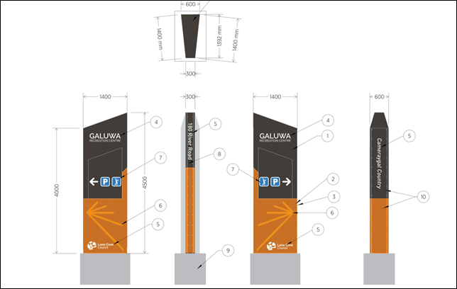
Figure 1: Extract from the proposed plans - Sign details.
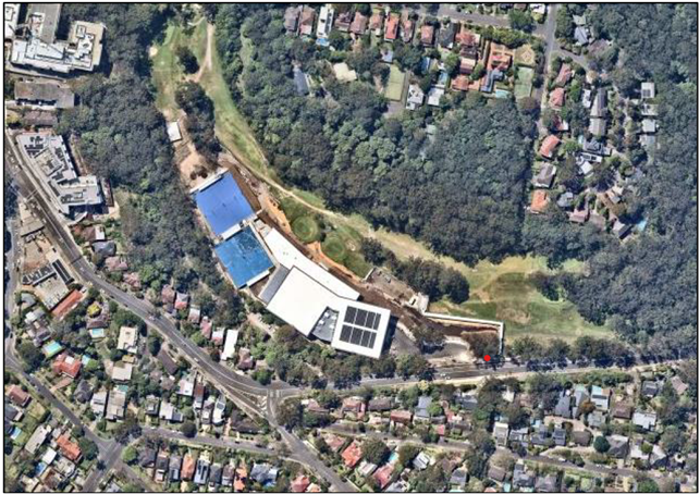
Figure 2: Aerial view of the subject site noting the
local context and sign location. (Source: NearMaps)
Location of proposed sign
|
|


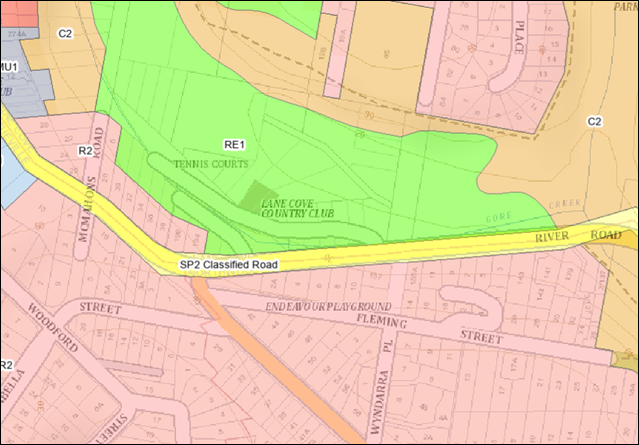
Figure 3: Extract from the Lane Cove LEP zoning map.
|
|
Location of proposed sign
|
|
Location of proposed sign
|
|
Location of proposed sign
|
|
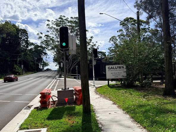
Figure 4: View of River Road looking west. The proposed
sign will be in the same location as the existing temporary sign.
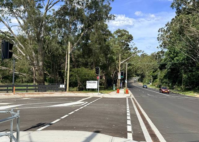
Figure 5: View of River Road looking east.
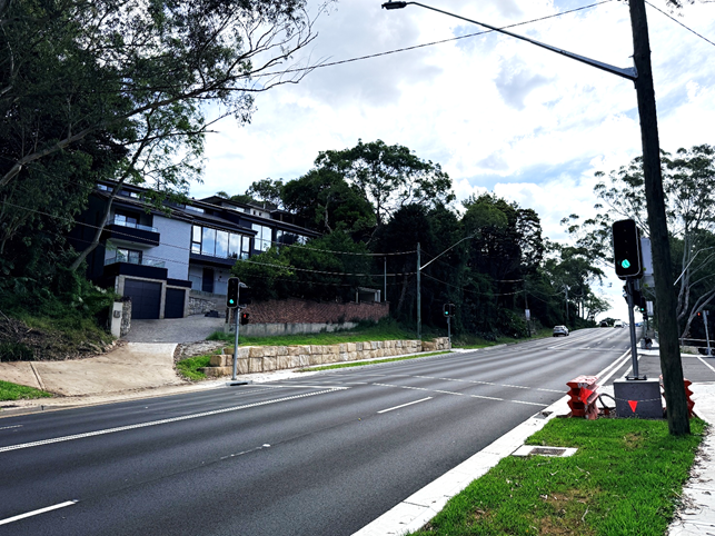
Figure 6: View of the nearest dwelling opposite the sign
- 157 River Road.


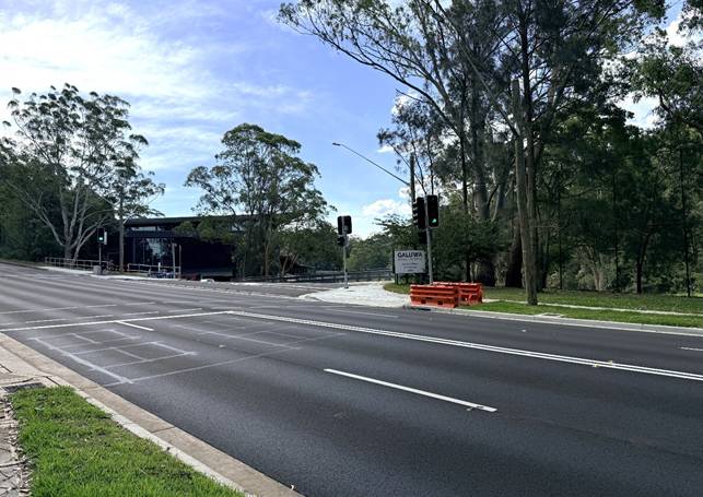
Figure 7: View of the proposed sign’s location from
the opposite side of River Road near No. 157.
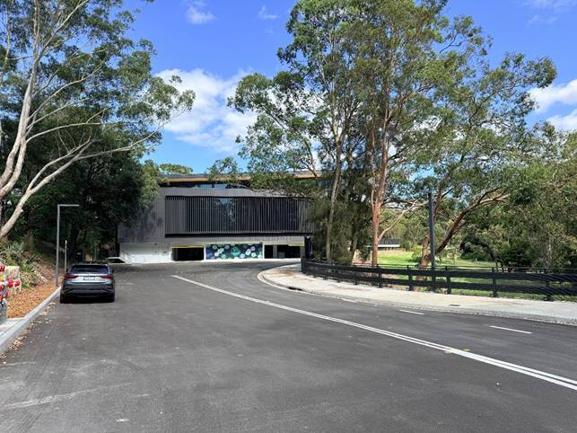
Figure 8: Eastern elevation of the new recreation
facility from the internal access road.
PART S - ASSESSMENT
The proposed works are below the
threshold cost of $250,000 and therefore an assessment against the provisions
of Part S Environmental Sustainability is not required.
REFERRALS
Development Engineer –
Part O – Stormwater Management
Council’s development
engineer has no objections to the proposal and has provided draft conditions of
consent should the application be approved.
Tree Officer’s Comments
Council’s tree officer has
no objections to the proposal and no conditions are required.
Bushland Manager
Council’s Bushland Manager has reviewed the proposed
development, raised no concerns and has not recommended any conditions.
Council’s Traffic Engineer
Council’s traffic engineer has reviewed the proposed
development, raised no concerns and has not recommended any conditions.
Assessment - Environmental Planning and Assessment Act
1979
provisions of any LEP, DCP, SEPP or regulation (Section
4.15(1)(a))
The proposal is permissible and
does not raise any issues in regard to the Lane Cove Local Environmental Plan
2009. The land use table explicitly notes signage as a permissible use in the
RE1 zone.
The proposal is not subject to a
floor space ratio or height of buildings development standard since such
development standards are absent in the RE1 zone.
Other Planning Instruments
State Environmental Planning
Policy (Industry and Employment) 2021
Chapter 3, Advertising and
Signage, of SEPP (Industry and Employment) 2021 applies to the application
except for signage that is exempt or complying development. The chapter also
does not regulate the content of signage and does not require consent for a
change in the content of signage. The SEPP prevails over any other
environmental planning instrument such as the Lane Cove Local Environmental
Plan to the extent of any inconsistencies with the SEPP.
The aims of Chapter 3 are as
follows:
3.1 Aims,
objectives etc.
(1) This Chapter aims
a) to ensure that
signage (including advertising):
(i) is
compatible with the desired amenity and visual character of an area, and
(ii) provides
effective communication in suitable locations, and
(iii) is
of high quality design and finish, and
(b) to regulate
signage (but not content) under Part 4 of the Act, and
(c) to provide
time-limited consents for the display of certain advertisements, and
(d) to regulate the
display of advertisements in transport corridors, and
(e) to ensure that
public benefits may be derived from advertising in and adjacent to transport
corridors.
Comment: Not all of the
objectives are applicable to the development however in general terms, the
signage is considered to be of low visual impact in the local environment as it
is designed to be directed at road traffic rather than residential properties.
As such, it is compatible with the land use and is not considered visually
detrimental to the character of the area.
Clause 3.4 provides as follows:
3.4 Signage to
which this Chapter applies.
(1) This Chapter applies to
all signage that:
a) can be displayed with or without development consent
under another environmental planning instrument that applies to the signage,
and
b) is visible from any public place or public reserve,
except as provided by this
Chapter.
Comment: The SEPP applies
by virtue of subclause (1)(b) as the sign is visible from a public place.
Clause 3.6 provides as follows:
3.6 Granting of
consent to signage.
A consent authority must not
grant development consent to an application to display signage unless the
consent authority is satisfied—
a) that the signage is consistent with the objectives of
this Chapter as set out in section 3.1(1)(a), and
b) that the signage the subject of the application
satisfies the assessment criteria specified in Schedule 5.
Comment: Council must be
satisfied that the objectives and assessment criteria are met.
Schedule 5 – Assessment
Criteria
1 Character
of the area
• Is
the proposal compatible with the existing or desired future character of the
area or locality in which it is proposed to be located?
Comment: Yes, the
sign is appropriate in its size in the context of its location and function. It
will provide identification of the recreation facility and guidance as to the
vehicular access point. The sign is considered compatible with the existing and
desired future character of the area.
• Is
the proposal consistent with a particular theme for outdoor advertising in the
area or locality?
Comment: There is no
particular theme for outdoor advertising in the area.
2 Special
areas
• Does
the proposal detract from the amenity or visual quality of any environmentally
sensitive areas, heritage areas, natural or other conservation areas, open
space areas, waterways, rural landscapes or residential areas?
Comment: The sign is
adjacent to the Galuwa Recreation Centre and the Lane Cove Golf Club however
these facilities are located in an urban area and signage such as that proposed
is considered both appropriate and necessary. The sign is designed to be mostly
visible to road traffic rather than from adjacent residential premises or open
space areas. The visual impact is considered to be controlled and is unlikely
to be offensive when viewed from the adjacent open space areas or residential
areas.
3 Views
and vistas
• Does
the proposal obscure or compromise important views?
• Does
the proposal dominate the skyline and reduce the quality of vistas?
• Does
the proposal respect the viewing rights of other advertisers?
Comment: No, the
proposed signage does not obscure or compromise views or impact on the skyline
or reduce the quality of the vista.
4 Streetscape,
setting or landscape
• Is
the scale, proportion and form of the proposal appropriate for the streetscape,
setting or landscape?
Comment: Yes. The
sign is considered to be of an appropriate size and scale having regard to its
intended function as an identification and directional sign and is considered
appropriate for the streetscape and landscape setting.
• Does
the proposal contribute to the visual interest of the streetscape, setting or
landscape?
Comment: The sign
serves a functional purpose and is not intended to provide visual interest in
the streetscape or landscape. The sign is considered an appropriate outcome in
the local context.
• Does
the proposal reduce clutter by rationalising and simplifying existing
advertising?
Comment: Yes. The
signage is not considered to result in visual clutter as the signage will stand
alone and is not cluttered by any other signage.
• Does
the proposal screen unsightliness?
Comment: No - not
applicable.
• Does
the proposal protrude above buildings, structures or tree canopies in the area
or locality?
Comment: No.
5 Site
and building
• Is
the proposal compatible with the scale, proportion and other characteristics of
the site or building, or both, on which the proposed signage is to be located?
Comment: Yes –
the sign is compatible with the scale of the recreation facility which it will
serve to identify. It is important that the sign be of sufficient size to give
motorists early warning of the location of the entrance to the facility.
• Does
the proposal respect important features of the site or building, or both?
Comment: Yes. The
proposal is not considered to be in conflict with any important features of the
site or the new recreation facility. The sign is compatible with the
recreational use of the site.
• Does
the proposal show innovation and imagination in its relationship to the site or
building, or both?
Comment: This is not
considered applicable to the type of signage proposed.
6 Associated
devices and logos with advertisements and advertising structures
• Have
any safety devices, platforms, lighting devices or logos been designed as an
integral part of the signage or structure on which it is to be displayed?
Comment: No, not
applicable to this type of signage.
7 Illumination
• Would
illumination result in unacceptable glare?
• Would
illumination affect safety for pedestrians, vehicles or aircraft?
• Would
illumination detract from the amenity of any residence or other form of
accommodation?
• Can
the intensity of the illumination be adjusted, if necessary?
• Is
the illumination subject to a curfew?
Comment: According to the
Statement of Environmental Effects
“The sign proposes
compliant illumination below the maximum allowable daytime
luminance with the nighttime
illumination level being programmed to operate at less than one quarter of the
daytime luminance. The sign will only be illuminated during the Centre’s
operating hours and contains no third-party advertising”.
A draft condition of consent is
proposed to ensure the sign is illuminated only during operational hours of the
facility. See draft condition 4.
8 Safety
• Would
the proposal reduce the safety for any public road?
• Would
the proposal reduce the safety for pedestrians or bicyclists?
• Would
the proposal reduce the safety for pedestrians, particularly children, by
obscuring sightlines from public areas?
Comment:
Satisfactory. The signage will provide warning to motorists of the entry point
of the facility. The intersection is controlled by traffic lights with a
pedestrian crossing. There are no obvious safety issues raised by the location
of the sign.
Having regard to the above
assessment it is concluded that the proposed sign satisfies the assessment
criteria under Schedule 5 and that the proposal is consistent with the
objectives of Chapter 3 as set out in section 3.1(1)(a).
APPLICABLE REGULATIONS
The Environmental Planning and
Assessment Regulation 2021 does not contain controls or regulations related to
signage and advertising.
Variations to Council’s
Codes/Policies
There are no variations sought to
Council’s codes or policies.
IMPACTS OF DEVELOPMENT
(Section 4.15(1)(b))
The proposal would not adversely
impact neighbouring properties or the public domain in terms of overshadowing,
visual privacy, acoustic privacy, or traffic and parking. The proposal presents
a development outcome that is consistent with the objectives of the relevant
planning controls.
SUITABILITY OF SITE (Section
4.15(1)(c))
The subject site is suitable for
the proposed development as the use is permissible within the RE1 Zone. The
proposed development would not unduly detract from the amenity of the
surrounding area.
RESPONSE TO NOTIFICATION
(Section 4.15(1)(d))
The application was notified to
adjoining properties in accordance with Council’s policy for the
notification of development applications. The notification period commenced on
2 December 2025 and concluded on 16 January 2026. No responses have been
received as a result of the notification process.
PUBLIC INTEREST (Section
4.15(1)(e))
The proposal would not have an
unreasonable impact on neighbouring properties or the public domain with regard
to the matters for consideration under the Lane Cove LEP 2009, Lane Cove DCP
2009 or the identified environmental planning instruments. Therefore, approval
of this application would not be contrary to the public interest.
CONCLUSION
The matters in relation to
Section 4.15 of the Environmental Planning and Assessment Act 1979 have been
satisfied.
The application complies with the
relevant controls as identified in this assessment report. The land does not
have an applicable Floor Space Ratio or Height of Buildings development
standard.
The application meets the
objectives of Part N, Signage and Advertising of the Lane Cove Development
Control Plan 2009.
On balance, it is considered that
the proposed development is reasonable, appropriate and is therefore
recommended for approval
|
RECOMMENDATION
That
pursuant to Section 4.16(1)(a) of the Environmental Planning and Assessment
Act 1979, the Lane Cove Local Planning Panel, at its meeting of 22 January
2026, grant development consent to:
Development
Application DA 144//2025 for:
· the removal and
installation of a pylon sign as described in the accompanying plans
· at 180 River
Road, Lane Cove,
subject to
the following conditions:
|
PART A – GENERAL CONDITIONS
1. A.1 - Approved
plans
Development must be carried out
in accordance with the following approved plans (stamped by Council), except where
the conditions of this consent expressly require otherwise.
|
Plan No
|
Revision
|
Plan Title
|
Drawn By
|
Dated
|
|
25024
Drawing Nos.
DA_01 to
DA_06.
|
B
|
Galuwa Recreation Centre. Pylon
sign DA Documentation.
|
Artscape
|
12/11/2025
|
In the event of any inconsistency
between the approved plans and a condition of this consent, the condition
prevails.
Reason: To ensure all parties
are aware of the approved plans and supporting documentation that apply to the
development
2. A.12 –
Construction Certificate
The submission of a Construction
Certificate and its issue by Council or Principal Certifier PRIOR TO
CONSTRUCTION WORK commencing.
Reason: To ensures the
detailed construction plans and specifications comply with the requirements of
the Building Code of Australia (BCA) and any relevant Australian Standard.
3. Future signage
content shall include English regardless of the inclusion of other languages.
4. The approved
signage shall not be illuminated outside of the operational hours of the
facility.
PART C - BEFORE THE ISSUE OF A
CONSTRUCTION CERTIFICATE
5. C.2 - Erosion
and sediment control plan
Prior to any demolition works or clearing of any vegetation and
before the issue of a construction certificate, the applicant is to ensure that
an erosion and sediment control plan is prepared in accordance with the
following documents before it is provided to and approved by the certifier:
· The
Lane Cove Development Control Plan 2009,
· the
guidelines set out in the NSW Department of Housing manual ‘Managing
Urban Stormwater: Soils and Construction Certificate’ (the Blue Book),
and
· the
‘Do it Right On-Site, Soil and Water Management for the Construction
Industry' (Southern Sydney Regional Organisation of Councils and the Natural
Heritage Trust).
The applicant must ensure the erosion and sediment control plan is
kept on- site at all times during site works and construction.
Reason: To ensure no substance other than rainwater enters the
stormwater
system
and waterways
6. C.23.B - Sydney
Water requirements
The approved plans must be
submitted to Sydney Water online approval portal “Sydney Water Tap
In” for approval.
Reason: To comply with the
requirements of Sydney Water.
7. C.1
- Construction site management plan
Prior to any demolition works and
before the issue of a construction certificate, the applicant must ensure a
construction site management plan is prepared before it is provided to and
approved by the principal certifier. The plan must include the following matters:
· Before
the commencement of any works, a safety barrier or temporary fencing is to be
provided covering the work area.
· the
location and materials for protective fencing
· provisions
for public safety
· the
location of site storage areas
· equipment
used to carry out all work.
· a
garbage container with a tight-fitting lid
· prior
to any excavation works, the location and depth of all services must be
ascertained. All costs associated with the adjustment of the public utility are
to be borne by the applicant.
The applicant must ensure a copy
of the approved construction site management plan is kept on-site at all times
during construction.
Reason: To require details of
measures that will protect the public, and the surrounding environment, during
site works and construction.
8. C.24.E -
Structural engineer’s details
The Construction Certificate plans and specifications must include
detailed professional structural engineering plans and/or specifications for
the following:
· Footings.
Reason: To ensure structural adequacy.
PART D -
BEFORE THE COMMENCEMENT OF BUILDING WORK
9. D.3 - Signs on
site
A sign must be erected in a
prominent position on any site on which building work or demolition work is
being carried out:
a) showing
the name, address and telephone number of the principal certifier for the work;
and
b) showing the name
of the principal contractor (if any) for any building work and a telephone
number on which that person may be contacted outside working hours; and
c) stating that
unauthorised entry to the work site is prohibited.
Any such sign is to be maintained
while any demolition or building work is being carried out but must be removed
when these works have been completed.
Note: This does not apply
in relation to building work, or demolition work, that is carried out inside an
existing building that does not affect the external walls of the building.
Reason: Prescribed condition
under section 70 of the Environmental Planning and Assessment Regulation 2021
(the Regulation).
PART E - WHILE BUILDING WORK
IS BEING CARRIED OUT
10. E.I.A. Hours of work
The principal certifier must
ensure that building work, demolition or vegetation removal is only carried out
between:
Monday to Friday (inclusive) 7.00am
to 5.30pm
Saturday 7.00am
to 4.00pm
With NO high noise generating
activities, to be undertaken after 12 Noon on Saturday.
A Notice/Sign showing permitted
working hours and types of work permitted during those hours, including the
applicant’s, Project Manager or Site Foreman phone number, shall be
displayed at the front of the site.
The principal certifier must
ensure building work, demolition or vegetation removal is not carried out on
Sundays and public holidays, except where there is an emergency.
Reason: To protect the amenity
of the surrounding area.
11. E.2 - Compliance with the
Building Code of Australia
Building work must be carried out
in accordance with the requirements of the Building Code of Australia.
Reason: Prescribed condition
under section 69 of the Regulations.
12. E.7 - Construction noise
While building work is being
carried out, the applicant is to ensure that any noise caused by demolition,
vegetation removal or works does not exceed an LAeq (15 min) of 5dB(A) above
background noise, when measured at any lot boundary of the property where these
works are being carried out.
Reason: To protect the amenity of the
neighbourhood.
13. E.15.B - Critical stage
inspections
Critical
stage inspections are to be carried out in accordance with Section 6.5 of the
Environmental Planning and Assessment 1979 and sections 61, 63 and 65 of the Environmental
Planning and Assessment (Development Certification and Fire safety) Regulation
2021.
Where Lane Cove Council is
appointed as the principal certifier, an inspection is to be booked for each of
the following relevant stages during the construction process:
a) Footings.
Reason: A requirement of the
Environmental Planning and Assessment Act 1979.
14. E.18.B - No obstruction of
public way
The public way and Council verge
must not be obstructed by any materials, vehicles, refuse, skips or the like,
under any circumstances. Non-compliance with this requirement will result in
the issue of a notice by Council to stop all work on site.
Reason: To ensure public
safety.
15. E.19.B –
Encroachments
The
proposed construction shall not encroach onto any existing
Council drainage pipe or easement unless approved by Council. If a Council stormwater
pipe is located on the site during construction, Council is to be immediately
notified. Where necessary the drainage line is to be reconstructed or relocated
to be clear of the proposed works. The applicant must lodge a Stormwater
Inspection Application form to Council. All costs associated with the
reconstruction or relocation of the drainage pipe are to be borne by the
applicant. The applicant is not permitted to carry out any works on existing
Council and private stormwater pipelines without Council’s approval.
Reason: To ensure works are
contained wholly within the subject site.
PART F - BEFORE THE ISSUE OF
AN OCCUPATION CERTIFICATE
16. F.1
- Works-as-executed plans and any other documentary evidence
Before the issue of the relevant
occupation certificate, the applicant must submit, to the satisfaction of the
principal certifier, works-as-executed plans, any compliance certificates and
any other evidence confirming the following completed works that Council
requires to be documented:
· certification
from a Sign Manufacturer that the Sign that has been manufactured and installed
satisfies the relevant Australian standards.
The principal certifier must provide a copy of the plans to
Council with the occupation certificate.
Reason: To confirm that the proposed works have been
constructed satisfactorily as per the approved plans.
17. F.4
- Preservation of survey marks
Before the issue of an occupation
certificate, a registered Surveyor must submit documentation to the principal
certifier which demonstrates that:
a) no existing survey mark(s) have been removed, damaged,
destroyed, obliterated or defaced, or
b) the applicant has re-established any survey mark(s)
that were damaged, destroyed, obliterated or defaced in accordance with the
Surveyor General’s Direction No. 11 – Preservation of Survey
Infrastructure.
Reason: To protect the State’s survey
infrastructure.
Assessed by:

Eugene Sarich
Town Planner
06/01/2026
ATTACHMENTS:
There are no supporting documents for this report.