Agenda
Lane Cove Local Planning Panel Meeting
15 April 2026

Notice of Meeting
Dear Panel Members,
Notice is given of the Lane Cove Local Planning Panel Meeting, to be held in the Council Chambers on Wednesday 15 April 2026 commencing at 5pm. The business to be transacted at the meeting is included in this business paper.
Yours faithfully

Louise Kerr
Lane Cove Local Planning Panel Meeting Procedures
The Lane Cove Local Planning Panel (LCLPP) meeting is chaired by Ms Janet Murrell or alternate Chairs. The meetings and other procedures of the Panel will be undertaken in accordance with any guidelines issued by the General Manager.
The order of business is listed in the Agenda on the next page. That order will be followed unless the Panel resolves to modify the order at the meeting. This may occur for example where the members of the public in attendance are interested in specific items on the agenda.
Members of the public may address the Panel for a maximum of 3 minutes. All persons wishing to address the Panel must register prior to the meeting by contacting Council’s Office Manager – Environmental Services on 9911 3611. Where there are a large number of objectors with a common interest, the Panel may, in its absolute discretion, hear a representative of those persons.
Minutes of LCLPP meetings are published on Council’s website www.lanecove.nsw.gov.au as soon as possible following the meeting. If you have any enquiries or wish to obtain information in relation to LCLPP, please contact Council’s Office Manager – Environmental Services on 9911 3611.
Please note meetings held in the Council Chambers are Webcast. Webcasting allows the community to view proceedings from a computer without the need to attend the meeting. The webcast will include audio of members of the public that speak during the meeting. Please ensure while speaking to the Panel that you are respectful to other people and use appropriate language. Lane Cove Council accepts no liability for any defamatory or offensive remarks made during the course of these meetings.
The audio from these meetings is also recorded for the purposes of verifying the accuracy of the minutes and the recordings are not disclosed to any third party under the Government Information (Public Access) Act 2009, except as allowed under section 18(1) or section 19(1) of the PPIP Act, or where Council is compelled to do so by court order, warrant or subpoena or by any other legislation.
DECLARATIONS OF INTEREST
APOLOGIES
NOTICE OF WEBCASTING OF MEETING
Lane Cove Local Planning Panel Reports
1. 47 Landers Road, Lane Cove................................................................................. 4
2. 243 Longueville Road, Lane Cove.................................................................... 33
Lane Cove Local Planning Panel Meeting 15 April 2026
47 Landers Road, Lane Cove
Item No: LPP5/26
Subject: 47 Landers Road, Lane Cove
Record No: DA26/20-01 - 21784/26
Division: Planning and Sustainability Division
Author(s): Annelize Kaalsen
|
Property: |
47 Landers Road, Lane Cove North |
|
DA No: |
DA20/2026 (PAN-616128) |
|
Date Lodged: |
05/03/2026 |
|
Cost of Work: |
$48,000.00 |
|
Owner: |
R Bordin |
|
Applicant: |
R Bordin |
|
Description of the proposal to appear on determination |
Construction of a double carport on western side with driveway entry from Kyong Street |
|
Zone |
R2 Low Density Residential |
|
Is the proposal permissible within the zone |
Yes |
|
Is the property a heritage item |
No |
|
Is the property within a conservation area |
No |
|
Does the property adjoin bushland |
No |
|
BCA Classification |
Class 10a |
|
Stop the Clock used |
No |
|
Notification |
Notified in accordance with Council’s Community Participation Plan and no submissions were received. |
REASON FOR REFERRAL TO LOCAL PLANNING PANEL
The applicant and owner of land is a member of Council staff who is involved in the exercise of Council’s functions under the Environmental Planning and Assessment Act 1979.
Accordingly, this application is reported to the Lane Cove Local Planning Panel (LCLPP) under the Minister’s Directions for determination.
Given that the land is owned by member of Council staff, in accordance with Council’s Managing Conflicts of Interest for Council-related development policy, the application is assessed by an independent external consultant Annelize Kaalsen of A K Planning.
EXECUTIVE SUMMARY
This development application seeks consent from the Lane Cove Local Planning Panel (LCLPP) for the construction of a double carport adjoining the western elevation at No. 47 Landers Road, Lane Cove North, with new crossing and driveway from Kyong Street.
As the applicant and owner is a member of Council staff who is involved in the exercise of Council’s functions under the Environmental Planning and Assessment Act 1979, this application is reported to the Lane Cove Local Planning Panel (LCLPP) under the Minister’s Directions for determination.
Given that the land is owned by member of Council staff, in accordance with Council’s Managing Conflicts of Interest for Council-related development policy, the application is assessed by an independent external consultant Annelize Kaalsen of A K Planning.
The land is zoned R2 Low Density Residential under the Lane Cove Local Environmental Plan 2009 (LCLEP 2009). The site is neither heritage listed nor located within a Heritage Conservation Area.
The application was notified for a period of 28 days from 5 March 2026 until 1 April 2026 and no submissions were received.
The assessment has considered the performance of the application against the relevant State Environmental Planning Policies, Lane Cove LEP 2009 and Lane Cove DCP 2009. In this regard, the application does not result in any adverse impact on the amenity of surrounding developments and is considered to be satisfactory.
The proposed carport provides functional off-street parking without adverse impacts on traffic, access, or local amenity, consistent with the relevant provisions of the LCLEP 2009 and DCP. It satisfies the applicable car parking controls through its open design, compliant setbacks, and non-trafficable roof, ensuring minimal impact on the streetscape. The siting on the secondary frontage reduces visual prominence and allows the primary frontage to retain its established character, with the dwelling and landscaping remaining the dominant elements. The scale, form, and materiality of the carport are compatible with the existing development and surrounding built form. The removal of four trees, including one on Council’s verge, is supported by the independent arborist and does not result in a significant environmental impact.
In conclusion, following this assessment, and having regard to the provisions of S4.15(1) of the Environmental Planning & Assessment Act 1979, it is recommended that the proposed development be approved subject to conditions as set out in this report.
THE SITE
|
Property |
Lot 22 Section 7 in DP7817. |
|
Area |
The site has an area of 801.2sqm |
|
Site location |
47 Landers Road, Lane Cove North. The site is located on the northern side of Landers Road and Eastern side of Kyong Street. |
|
Existing improvements |
Existing development on the site includes a single storey brick dwelling with a tiled roof and single-storey fibre cement weatherboard extension with metal roof. The site also has a dilapidated garage currently used for storage. |
|
Shape |
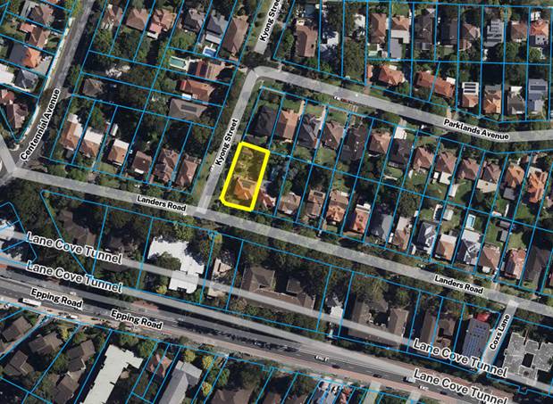
The site has an irregular rectangular shape and is located at the junction of Landers Road and Kyong Street – refer to Figure 1. |
|
Dimensions |
Northern boundary dimension of 18.26m Eastern boundary dimensions of 40.46m Southern boundary dimension of 21.34m Western boundary dimension of 40.56m |
|
Adjoining properties |
The surrounding area is characterized by low density residential development, comprising of mostly freestanding single and double storey dwelling houses. The site is a corner allotment with its southern boundary to Landers Road and western boundary to Kyong Street. To the north the site adjoins No. 50 Parklands Avenue, a part single part two storey dwelling house with a double carport to Kyong Street. Towards the east of the site adjoins No. 45 Landers Road, which is a single storey dwelling house. The southern side of Landers Road, contains low rise multi-dwelling apartments within the R4 zoning. |

Figure 1: Aerial locality plan of No. 47 Landers Road

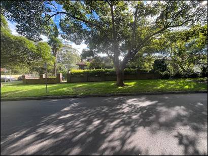
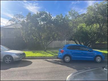
Photo 1: The subject site as viewed from Landers Road

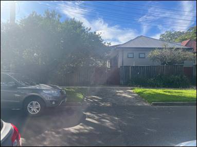
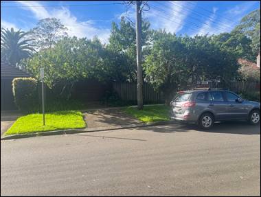
Photo 2: The subject site as viewed from Kyong Street


Photo 3: Existing western elevation / location of new carport outlined in red

Photo 4: Existing garage and crossing

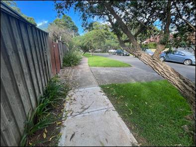
Photo 5: Existing crossing to be removed

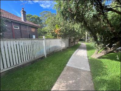
Photo 6: Street Tree (T4 Weeping bottlebrush) to be removed
SITE APPLICATION HISTORY
|
CDC 173/2022 |
Alterations and additions to dwelling house |
PROPOSAL
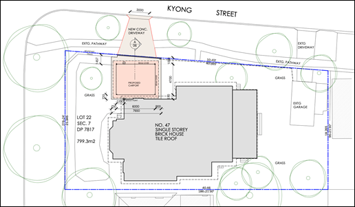
The development application is seeking consent for the construction of a new double carport with associated new crossing and driveway from Kyong Street .
In more detail the proposed works include:-
· Removal of four (4) trees including a street tree (T4 a Weeping bottlebrush);
· New crossing and driveway off Kyong Street (crossing 3m wide with 500mm splays on both sides);
· Double carport with internal dimensions of 4.6m x 6m with a pitched roof and 100mm x 100mm SHS columns to each corner;
· Removal of historical concrete driveway;
· Retention of outbuilding (detached existing garage) used for storage rather than carparking and associated driveway; and
· Removal of existing paving and associated landscape works.

Figure 2: Proposed Floor Plan

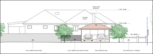
Figure 3: Proposed western elevation

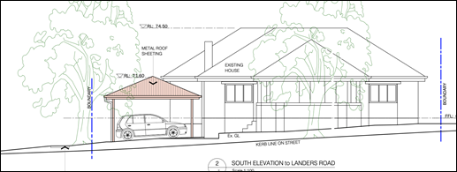
Figure 4: Proposed southern elevation
Assessment - Environmental planning and assessment act 1979
The objects of the Environmental Planning and Assessment Act 1979 are guiding principles that need to be considered by planning authorities when making decisions under the Act.
The proposed development is consistent with the objects because:-
· It will result in the orderly and economic use and development of land as the site is of an appropriate size, location and land use zoning to enable the proposed development;
· appropriate utility services are available;
· there will be no unreasonable adverse amenity impacts on the environment; and
· it represents an appropriate form of development that supports the ongoing residential use of the site without adverse environmental impact.
provisions of any lep, dcp, SEPP or regulation (Section 4.15(1)(a))
The proposal is permissible and does not raise any issues in regard to the Lane Cove Local Environmental Plan 2009 – refer to Section 4.15 Assessment of this report below.
Other Planning Instruments
SEPP (Resilience and Hazards) 2021
Chapter 4 - Remediation of Land
Chapter 4 of Resilience and Hazards SEPP aims to ‘provide a State-wide planning approach to the remediation of contaminated land’. Clause 4.6 requires a consent authority to consider whether the land is contaminated and if it is suitable or can be remediated to be made suitable for the proposed development, prior to the granting of development consent.
The subject site has been used continuously for residential purposes for a number of years. Given this ongoing use, it is unlikely that the site is contaminated.
SEPp (Biodiversity and Conservation) 2021
The two relevant chapters are addressed under the following subheadings.
Chapter 2 Vegetation in non-rural areas
The aims of Chapter 2 have been satisfied as the proposed development would have no adverse impact on the biodiversity value of trees and other vegetation.
The application seeks to remove four (4) trees including a Weeping Bottlebrush being a Council street tree to facilitate the new crossing and driveway. An independent arborist raised no objection subject to conditions of consent – refer to the Referral section of this report below for more detail.
Subject to the recommended conditions of consent, the proposed development is considered to be consistent with and satisfies the aims of Chapter 2 of the SEPP, as it will not result in any unacceptable impacts on the biodiversity values of trees and other vegetation.
Chapter 6 Water
catchments
The site is located within the Sydney Harbour Catchment. The proposed works are minor in nature and include appropriate stormwater management measures. The development will not result in any adverse impact on water quality entering the catchment and is consistent with the aims of this chapter.
SECTION 4.15 ASSESSMENT
The following assessment is provided against the relevant provisions of Section 4.15 of the Environmental Planning and Assessment Act, 1979:
Lane Cove Local Environmental Plan 2009
Aims of Plan
The proposed development is considered to be consistent with the aims of the Lane Cove Local Environmental Plan 2009, as outlined under Clause 1.2(2). In particular, the siting on the secondary frontage and subordinate scale maintains the existing character and amenity of the locality consistent with Clause 1.2(2)(b) Character and Amenity. The design, scale and siting of the carport ensure it is compatible with surrounding built form and environmental character consistent with Clause 1.2(2)(f)(iii) Built Form Compatibility. Consistent with Clause 1.2(2)(h) Land Use and Transport Integration, the proposal provides functional off-street parking on the secondary frontage without adverse impacts on local traffic or access.
Accordingly, the proposal is considered to achieve the relevant aims of the Plan.
|
Zoning: |
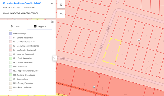
The subject site is zone R2 Low Density Residential – see Figure 5.
The proposed development is consistent with the zone objectives in that: · The proposal retains the low density residential zoning; · The proposal provides for facilities to service the day to day needs of the residents; and · Ensures that landscaping is maintained and enhanced. |
|
Permissibility: |
The proposed carport is ancillary to the dwelling which is a permissible use with consent in the R2 Low Density Residential zone. |

Figure 5: R2 Low Density Residential Zoning Map
The table below demonstrate consistency with the LCLEP 2009.
|
LCLEP 2009 TABLE |
|||
|
Clause |
Development Standard |
Proposal |
Complies |
|
Clause 4.3 Height of Buildings (max) |
The subject site has a 9.5m maximum height on the height of building map |
The proposal does not alter the existing dwelling height The carport has a height of 3.6m |
Yes |
|
Clause 4.4. Floor Space Ratio (max) |
The subject site has an FSR of 0.5:1 on the FSR map |
The proposal would not alter the existing FSR |
Yes |
|
Clause 5.10 Heritage Conservation |
The subject site does not include a heritage item nor is it located within a heritage conservation area |
N/A |
N/A |
|
Clause 5.21 Flood Planning |
The subject site is not identified as flood prone land |
N/A |
N/A |
|
Clause 6.1 Acid Sulfate soils |
The subject site does not contain acid sulfate soils |
N/A |
|
|
Clause 6.1A Earthworks |
|
No earthworks proposed other than footings for the new carport. |
N/A |
Lane Cove Development Control Plan 2009
Part C.1 Dwelling Houses and Dual Occupancies
1.2 Streetscape
The proposed carport is open in nature and of a scale and appearance consistent with the streetscape and neighbourhood character. It maintains visual continuity and the established pattern of built elements fronting the secondary frontage and does not dominate the dwelling or surrounding streetscape.
The development includes removal of existing hardstand areas, improving compliance with landscaped open space requirements and maintaining the landscape character of the area.
Numerical matters relevant to this proposal
|
Control |
Proposed |
Complies |
|
1.3 Setbacks
Front (primary) Consistent with prevailing or 7.5m Secondary street 2m
Side 1.2m for a single storey dwelling 1.5m for a two storey dwelling. Less than 1.2m may be considered for an open carport where there would be no unreasonable amenity impacts.
Rear 8m or 25% of the site depth |
Front Primary Street = 7.4m to roofline and 7.9m to posts
Secondary street = 1m to post and 450mm to roofline
Side and Rear 26m from northern 13.8m to eastern
|
On merit refer to discussion on design and setbacks below |
|
1.4 Fences Solid = 900mm above EGL 1.2m on the front boundary, with max solid 600mm 1.8m setback 1m from the front boundary with max solid 600mm.
|
The existing brick wall is to remain. The proposed works are limited to like for like repairs.
Photo 7: existing front fence |
A condition of consent is recommended stating that no approval is granted for any new fencing. It is noted that like for like repair work could be carried out. |
|
1.5 Landscaped area (min35%) |
354.01sqm or 44.18% |
Yes |
|
1.6 Cut and fill (max 1m) |
Less than 1m |
Yes |
1.8 Amenity
1.8.1 Solar access and overshadowing
The proposed carport, located to the west of the existing dwelling adjoining Kyong Street, is open and single storey in form and will not result in overshadowing of adjoining habitable rooms or private open spaces. Any additional overshadowing will be limited to the street or the subject site.
1.8.2 Privacy – Visual and Acoustic
The proposed carport does not result in any opportunity for overlooking of adjoining habitable spaces.
1.8.3 Private Open space
The location of the carport along the secondary street frontage does not impact the site’s ability to provide private open space. An area of sufficient size and dimension is retained at the rear of the dwelling, directly accessible from the living areas.
1.9 Car parking
|
Control |
Proposed |
Complies |
|
Off - street spaces min 2 spaces |
2 |
Yes |
|
Driveway width 3m at the kerb, plus 500mm cutaways on both sides (i.e. 4m in total). |
3m, plus 500mm cutaways/splays on both sides |
Yes |
Carports within the front setback (secondary street frontage)
|
Control |
Proposed |
Complies |
|
Setback of posts min1m from street boundary |
1m |
Yes |
|
% of allotment width 21.43) 50% of lot width or 6m, whichever is the lesser (the latter is the lesser) |
6m to posts 7m (incl roof overhang/eaves) |
Yes |
Design and Setbacks
Control a) of Clause 1.9 Car parking states that a carport is permitted within the front setback if it satisfies the following design criteria:
i. The carport has an open design and has minimal impact on the streetscape
ii. The carport does not have a trafficable roof
iii. Open security gates (with a minimum of 50% openings) are permitted
iv. The carport posts are to be setback a minimum of 1.0m from the street alignment (refer Diagram 6).
Comment
The proposed carport satisfies the relevant design criteria. It adopts an open design, being open on all sides, and does not include a trafficable roof or security gates. The supporting posts are setback a minimum of 1.0m from the secondary street alignment, consistent with the control.
The carport measures 6m in width between posts, whilst the slab extends to 7.6m to allow for safe and convenient vehicle access. This provides adequate clearance for a standard passenger vehicle and enables comfortable ingress and egress on both sides. The extended slab also integrates with the existing pathway leading to the front porch, improving pedestrian accessibility – refer to Photo 8.

Photo 8: existing pathway to front porch
The siting of the carport with its entry from Kyong Street reduces its visual prominence when viewed from the primary frontage to Landers Road. This assists in maintaining the established streetscape character, where the dwelling and landscaped setting remain the dominant visual elements.
There are no significant water or bushland views affected by the proposal.
The scale and form of the carport have been carefully designed to complement the existing development and surrounding built form. The use of materials and colours are consistent with the recent extension and neighbouring properties, which further reduces visual impact and ensures a cohesive appearance within the streetscape.
The existing dilapidated garage is noted by the applicant to be used for storage. Irrespective of whether the existing outbuilding is currently used as a garage or is proposed to be used as a store room, the inclusion of its floor space does not raise any issue in relation to the FSR as this would not exceed 50sqm.
Overall, the proposed carport is consistent with the design criteria and objectives of the car parking provisions, as it achieves a low visual impact, maintains the character of the streetscape, and provides functional and well-integrated parking.
1.9.1 Driveways and pathways
The proposed double carport would be accessed by a new crossing being 3.0m wide at the kerb plus 500mm splays on both sides. The proposed driveway tapers from 4.0m at the kerb to 6.0m at the property boundary to accommodate the double carport.
The proposal seeks to replaces a redundant driveway with a new driveway accessing the proposed new carport. The proposed driveway is perpendicular to the Kyong Street boundary, supporting safe vehicle entry and exit.
Council’s Development Engineer has included a condition specifying a driveway crossing width at the face of the kerb of no greater than 4m (for a single crossing) and 5.5m for a double crossing.
As currently drafted, the condition could be interpreted as supporting a double-width crossing from the kerb to the property boundary, which is inconsistent with the proposed plans.
It is recommended to not increase the width of the crossing, particularly given that an existing crossing is to be retained for access to the dilapidated garage. This would result in not only multiple crossings over a single frontage, but also wider crossings, which is undesirable from both a streetscape and safety perspective.
In addition, a 5.5m wide crossing at the kerb is likely to encroach upon the TPZ of the street tree proposed to be retained, resulting in potential impacts to its health and structural stability.
Accordingly, it is recommended to amend the recommended condition of consent to read as follows:
C.27.E Proposed vehicular crossing
…
b) The driveway opening/crossing width at the face of the kerb is to be no wider than 4m (3m plus 500mm splays on either side) tapering to no wider than 5.5m at the site boundary…
1.9.2 Vehicular access
The proposed carport entry is located on the secondary street frontages consistent with control (b). Council’s Development Engineer raised no concern and recommended a condition of consent that the driveway and access ramp /crossing are to be designed in accordance with the relevant Australian Standard.
1.10.3 Outbuildings (the proposed carport)
|
Control |
Proposed |
Complies |
|
Overall height Max 3.6m |
3.6m |
Yes |
|
External wall height max 2.4m |
- |
N/A |
|
Floor space max 50sqm |
- |
N/A |
|
No. of storeys 1 |
1 |
Yes |
|
Setback of windows from boundaries min 900mm |
Nil |
N/A |
Part J - Landscaping and Tree Preservation
The site contains a number of trees. The application seeks to remove a street tree to facilitate the new driveway and crossing. An arborist report accompanies the application assess seventeen (17) trees. Of the 17 trees assessed, six (6) trees are located on the Council nature strips either on Landers Road or Kyong Street. Ten (10) trees have been assigned a category A rating using the trees AZ method. These trees were generally seen in good health and condition, requiring minor or no remedial works. Seven (7) trees have been assigned a category Z rating.
The applicants’ arborist report identifies four trees for removal, required due to being within the footprint of the proposed carport or new driveway/crossing, being:
· T4 a Weeping Bottlebrush located on Councils verge, identified as a Category A tree
· T9 & T10 both White Bottlebrush located on the subject site adjoining the western boundary, both identified as a category Z tree
· T11 a Camellia located on the subject site adjoining the western boundary, identified as a category Z tree.
In addition T3 requires pruning for vehicular clearance. The arborist report identifies pruning to the co-dormant stem. The SEE notes that additional trees will be planted to offset any trees removed.
An independent arborist (Seasoned Tree Consulting) reviewed the plans and applicant’s Arborist report and concurred with the recommended tree removal and pruning required. Seasoned Tree Consulting raised no concern subject to conditions of consent – refer to detail under Referral section of this report.
Part O: Stormwater Management
The proposed stormwater design involves replacing the existing on-site pit with a new compliant, trafficable pit, installing a grated drain at the street boundary, and connecting to the existing kerb outlet. The site will continue to drain to Council’s system via a lawful point of discharge at the Kyong Street frontage.
The upgraded pit will be constructed to current standards, maintaining existing connection levels, accommodating vehicle loads in accordance with AS3996, and allowing for ongoing maintenance. Roof and surface water from the carport will be connected to the existing system with new gutters and downpipes, connecting to the new stormwater pit.
Total impervious area is calculated to be 462sqm or 57.8%.
Councils Development Engineer raised no concerns in this respect, subject to conditions of consent.
Part Q: Waste Management and Minimisation
A standard condition of consent is recommended to minimize waste during demolition / removal of existing paving and concrete driveway.
Part R Traffic, Transport and Parking
A residential dwelling with one or more bedrooms must be provided with a minimum of 1 allocated car parking space. The proposal allows for 2 off street carparking spaces consistent with the DCP requirement.
All parking areas, including access ramps and driveways, must be designed in accordance with the relevant Australian Standards, a condition of consent is recommended.
Part S, Environmental Sustainability
The proposed works amount to a cost less than $250,000 and therefore the provisions of Part S do not apply.
REFERRALS
Development Engineer – Part O – Stormwater Management
Council’s Development Engineer raised no objections subject to recommended conditions.
Ausgrid – Clause 2.48 of SEPP (Transport and Infrastructure)
Ausgrid granted consent, subject to conditions.
Independent Arboricultural external referral
The application was referred to an independent arborist (Seasoned Tree Consulting) which provided the following comments:-
“I have reviewed the findings of the submitted AIA for each of the 17 assessed trees against the plans, survey and DCP requirements. In summary:
• Ten (10) trees are assigned a Category A retention value (A1 or A2) and ten (10) trees a Category Z value (Z1, Z9 or Z10). I consider the retention values assigned to be consistent with the observed condition, structural characteristics, useful life expectancy and site context of each tree.
• Four (4) trees are recommended for removal: T4 (A2-rated street tree within crossover footprint), T9 and T10 (Z1-rated small bottlebrushes within carport footprint) and T11 (Z10-rated camellia within carport footprint). I concur with each removal recommendation.
• The remaining thirteen (13) trees are recommended for retention with varying degrees of protection and supervision, consistent with the nature and extent of proposed encroachments.
• NRZ encroachments are identified for T3 (<1%), T6 (15.3%), T7 (19.37%), T14 (14.12%), T15 (13.12%) and T16 (16.07%). These encroachments are appropriately characterised as minor or moderate-to-major under AS 4970-2025, with mitigation methodologies proposed that I consider adequate to support tree viability.
• The replacement of impervious concrete crossovers and paving with grass, as proposed for trees T6, T7, T14, T15 and T16, is a legitimate and well-supported basis for concluding net benefit to those trees, subject to the supervision requirements specified”.
In addition the independent arborist noted that replanting and canopy replacement will be required:-
“Four trees are proposed for removal under this application. Compensatory replanting should be required as a condition of consent at a minimum 1:1 ratio, consistent with Lane Cove DCP Part J requirements. Replacement species should be selected from Council’s Approved Tree Replacement List (DCP Part J, Appendix 3). Given the nature strip context, Council’s approval for any replanting within the public road reserve will also be required”.
No objection is raised subject to conditions of consent, along with appropriate replacement tree planting and tree protection measures.
APPLICABLE REGULATIONS
Section 61(1) of the Environmental Planning and Assessment Regulation 2021 requires the consent authority to consider compliance with AS 2601-2001: The Demolition of Structures. A condition of consent seeking compliance with this Standard is recommended.
IMPACTS OF DEVELOPMENT (Section 4.15(1)(b))
Built
The overall impact of the proposed carport on both the adjoining properties, and the streetscape in general, would be reasonable.
Natural
Although the proposal would result in a reduction of the landscaped area along the site’s secondary street frontage, the remaining landscaped area would continue to exceed the minimum requirements of the DCP.
Subject to Condition 4, the proposed driveway will necessitate the removal of four (4) trees, including one located within Council’s verge along Kyong Street. No other trees would be affected by the proposed works.
Overall, the impact of the proposal on the natural environment is not considered to be significant.
SUITABILITY OF SITE (Section 4.15(1)(c))
The proposed development is suitable for the site as the proposed development is permissible within the Zone.
RESPONSE TO NOTIFICATION (Section 4.15(1)(d))
The application was notified in accordance with Council’s Community Participation Plan 2019 from 5 March 2026 to 1 April 2026. No submissions were received.
PUBLIC INTEREST (Section 4.15(1)(e))
The proposed development would have no adverse impacts on neighbouring properties and the public domain with regard to the Lane Cove LEP 2009 and Lane Cove DCP and the relevant environmental planning instruments. Therefore, approval of this application would not be contrary to the public interest.
CONCLUSION
The matters in relation to Section 4.15 of the Environmental Planning and Assessment Act 1979 have been satisfied.
The application is acceptable having regard to the Lane Cove LEP 2009 and the Lane Cove DCP. The proposal will provide a functional and well-integrated car parking solution that is compatible with the existing development, maintains the character and amenity of the locality, and results in minimal impacts on the streetscape and natural environment.
On balance, as the proposed development is considered reasonable, it is therefore recommended for approval.
|
RECOMMENDATION
That pursuant to Section 4.16(1)(a) of the Environmental Planning and Assessment Act, 1979 the Lane Cove Local Planning Panel at its meeting of 15 April 2026, exercising the functions of Council as the consent authority, grant consent to Development Application DA20/2026 for the construction of a carport on the western side with new driveway crossing entry from Kyong Street located at No. 47 Landers Road, Lane Cove North, subject to the following conditions of consent:-
PART A – GENERAL CONDITIONS
1. A.1 - Approved plans Development must be carried out in accordance with the following approved plans (stamped by Council), except where the conditions of this consent expressly require otherwise.
In the event of any inconsistency between the approved plans and a condition of this consent, the condition prevails.
Reason: To ensure all parties are aware of the approved plans and supporting documentation that apply to the development.
2. No approval for new fencing No approval is granted for any new fencing. Like-for-like repair or maintenance of the existing fence may be carried out only.
Reason: To ensure the development is consistent with the approved plans and to prevent unauthorised works.
3. A.3 - Payment of security deposits Before the commencement of any works on the site, or the issue of a construction certificate, the applicant must make the following payments to Council and provide written evidence of these payments to the principal certifier:
A payment of $9,000.00 (refundable) and $920 (non-refundable) shall be lodged with Council to cover the satisfactory construction of the above requirements.
To make this payment, contact Lane Cove Council Customer service team.
The mode of payment shall only be non-cash payments (Credit card, Bank cheque, EFT) or Bank Guarantee lodged with Council.
The payments will be used for the cost of: · making good any damage caused to any council property (including street trees) as a consequence of carrying out the works to which the consent relates. · completing any public work such as roadwork, kerbing and guttering, footway construction, stormwater drainage and environmental controls, required in connection with this consent. · any inspection carried out by Council in connection with the completion of public work or the making good any damage to council property.
Note: The inspection fee includes Council’s fees and charges and includes the Public Road and Footpath Infrastructure Inspection Fee (under the Roads Act 1993). The amount payable must be in accordance with council’s fees and charges at the payment date.
Note: Council inspection fees are calculated in accordance with Council’s fees and charges at the payment date.
Note: Required Council inspections for civil works involving Council assets are to be carried out prior to the pouring of any concrete (formwork) and on completion of the construction. An initial site meeting is to be conducted with council and the contractor prior to the commencement of any of the above works to allow for discussion of Council construction / set out requirements.
The following items are to be inspected: · footpath, kerb/gutter and landscaping works at redundant driveway area; and · any adjustment works in Council’s land.
Reason: To ensure any damage to public infrastructure is rectified and public works can be completed.
4. A.7.L - Tree preservation and approved landscaping works
The following trees shall be retained:
This consent gives approval for the removal of the following trees:
Advisory Note: The protection of trees in Lane Cove is regulated under the State Environmental Planning Policy (Biodiversity and Conservation) 2021 (the SEPP) parts 2.2 and 2.3 which prohibits the clearing of vegetation without the authority conferred by a permit granted by Council. Clearing under the SEPP is defined as: a) cut down, fell, uproot, kill, poison, ringbark, burn or otherwise destroy the vegetation, or (b) lop or otherwise remove a substantial part of the vegetation. The clearing of trees or vegetation protected by this SEPP is an offence against the Environmental Planning and Assessment Act 1979 (NSW). The maximum penalty that may be imposed in respect to any such offence is $1,100,000 per individual and $5,500,000 per corporation. Reason: To ensure the protection of trees to be retained and to confirm trees removed for pruning/removal.
5. A.9.T - Works on Council land A separate application shall be made to Council’s Open Spaces and Infrastructure Division for any associated works on Council property. Written approval is to be obtained prior to the start of any works on Council property.
Where the applicant requires the use of construction plant on the public road reservation, an “Application for Standing Plant Permit” shall be made to Council. Applications shall be submitted and approved prior to the start of any related works. Note: allow 2 working days for approval.
Reason: To manage impacts to Council’s assets.
6. A.10.E Drainage plan amendments Before the issue of a construction certificate, the certifier must ensure the approved construction certificate plans (and specifications) detail the following required amendments to the approved stormwater drainage plans in architectural plan prepared by Melissa Treadgold Architects, Drawing No: 03a issue: DA and dated on 18/11/25. This amended plan shall satisfy Part O - Stormwater Management of the Lane Cove Council Development Control Plan 2009.
1. All new down pipes shall be connected to appropriate pipe system. 2. Proposed drainage system should show pipe sizes and invert levels up to the connection point; confirming pipe system satisfies Part O - Stormwater Management of the Lane Cove Development Control Plan 2009. 3. Sediment control fence shall be placed around the construction site and shown in plan. 4. As per survey plan, there is a pit at proposed carport area. The applicant has not provided any details of this pit. This pit can be modified into a standard pollution control pit (as shown in section 3.4.1 in Part O - Stormwater Management of the Lane Cove Council Development Control Plan 2009) with mesh (RH3030) and sump(300mm). 5. Driveway grated strip pit shall have minimum 200mm of depth and minimum 1% fall inside. 6. The kerb discharge point shall be minimum 300mm away from edge of driveway wing and complied with section 4.1 of Part O - Stormwater Management of the Lane Cove Council Development Control Plan 2009. 7. Installation of pipe system near the Council’s and protected trees must be to the satisfaction of Council’s Tree Officer.
Certification from a suitably qualified engineer as to the matters below is to be provided to the Principal Certifying Authority, prior to the issue of any CC: a) Compliance with the amendments detailed in this condition. b) Compliance with Part O - Stormwater Management of the Lane Cove Council Development Control Plan 2009.
Where a variation is sought, written approval is to be obtained from Council’s Open Spaces & Infrastructure Division.
Reason: To ensure adequate stormwater management in accordance with Part O - Stormwater Management of the Lane Cove Council Development Control Plan 2009.
7. A.12 – Construction Certificate The submission of a Construction Certificate and its issue by Council or principal certifier PRIOR TO CONSTRUCTION WORK commencing.
Reason: To ensures the detailed construction plans and specifications comply with the requirements of the Building Code of Australia and any relevant Australian Standard.
AUSGRID CONDITIONS
8. New Driveways - Proximity to Existing Poles
Proposed driveways shall be located to maintain a minimum clearance of 1.5m from the nearest face of the pole to any part of the driveway, including the layback, this is to allow room for future pole replacements. Ausgrid should be further consulted for any deviation to this distance.
9. New or modified connection
To apply to connect or modify a connection for a residential or commercial premises. Ausgrid recommends the proponent to engage an Accredited Service Provider and submit a connection application to Ausgrid as soon as practicable. Visit the Ausgrid website for further details; https://www.ausgrid.com.au/Connections/Get-connected
PART B – PRIOR TO DEMOLITION WORKS
10. B.3.EH - Compliance with demolition standard Demolition of buildings and structures must comply with Australian Standard AS 2601—2001: The Demolition of Structures.
Reason: Prescribed condition under the EP&A Regulation 2021.
Prior to the commencement of any works including demolition, a project arborist of minimum Australian Qualification Framework (AQF) Level 5 is to be appointed to oversee/monitor tree protection compliance during the construction process. A letter of engagement from the Project Arborist must be provided to Council prior to issue of a construction certificate. Compliance certificates (with photos) for each attendance and key stages must be provided to the principal certifier within 5 days of such and to Council upon request.
The project Arborist shall: 1. Certify all tree protection measures listed within the Tree Protection Plan located within Section 8.8.3 of the Arboricultural Impact Assessment report by Axiom Arbor Tree Services dated Oct 2025 have been installed prior to demolition works
2. Clearly identify and tag trees (where appropriate) which are to be removed, and which trees are to be retained as part of this consent
3. Oversee the works within TPZs.
4. Submit a statement upon completion for the development that all retained trees have been maintained in a healthy, viable condition and replacement planting has been undertaken. The statement must also recommend remedial advice for trees post construction to mitigate any long-term construction impacts.
Reason: To ensure trees to be protected on the site.
12. B.14A - Special Condition - Tree Protection Measures Fencing/Trunk Protection The following tree protection measures must be in place prior to demolition works and certified by the project arborist.
Tree Protection Fencing must be in accordance with the approved tree protection plan located within Section 8.8.3 of the Arboricultural Impact Assessment report by Axiom Arbor Tree Services dated Oct 2025.
Where fencing has been specified, the fencing must consist of a 1.8 m high chain mesh fence held in place with concrete block footings and fastened together. An example of fencing is shown under figure 4 on page 18 of the Australian Standard 4970-2025 - Protection of trees on development sites.
The fenced area shall not be used for the storage of building materials, machinery, site sheds, or for advertising and the soil levels within the fenced area shall remain undisturbed.
Where Trunk protection has been specified the trunks of the trees must be protected during the construction period by a trunk guard that consists of the following:
Timber Planks (50mmx100mm or similar) shall be placed at 100mm intervals and must be fixed by wire ties or strapping to a height of 2m.
Hessian cloth is to be placed between the trunk and the planks to minimise damage. The timber planks are not to be fixed directly to the tree in any way.
An example of suitable trunk protection can be found on page 17 within the Australian Standard 4970-2025 - Protection of trees on development sites.
A waterproof sign must be placed on every second panel stating, ‘NO ENTRY TREE PROTECTION AREA – this fence and sign are not to be removed or relocated for the work duration.’ Minimum size of the sign is to be A3 portrait with NO ENTRY TREE PROTECTION ZONE in capital Arial Font size 100, and the rest of the text in Arial font size 65.
Tree Protection fencing/trunk protection and signage must be erected prior to demolition including site preparation and remain in place for the duration of the construction work.
Any movement of Tree Protection Fencing must be overseen and approved by the Project Arborist.
Where Ground protection has been specified, the ground protection must be provided within designated access routes or work zones inside TPZs specified in the TPP (geotextile + ≥100 mm coarse woodchip + interlocked rumble boards) and must be installed prior to demolition and retained for the duration of works.
Reason: To protect the natural environment
PART C - BEFORE THE ISSUE OF A CONSTRUCTION CERTIFICATE
13. C.1 - Construction site management plan Prior to any demolition works and before the issue of a construction certificate, the applicant must ensure a construction site management plan is prepared before it is provided to and approved by the principal certifier. The plan must include the following matters:
· before commencement of any works, safety barrier or temporary fencing is to be provided covering work area. · the location and materials for protective fencing and hoardings to the perimeter on the site. · provisions for public safety · pedestrian access, including disabled and pram access, is to be maintained throughout the course of the construction as per AS-1742.3, ’Part 3 - Traffic control devices for works on roads’. · pedestrian and vehicular site access points and construction activity zones · the location of site storage areas and sheds · equipment used to carry out all work. · a garbage container with a tight-fitting lid · prior to any excavation works, the location and depth of all services must be ascertained; all costs associated with adjustment of the public utility will be borne by the applicant. · protection measures for Council’s existing drainage system, trees and street assets.
The applicant must ensure a copy of the approved construction site management plan is kept on-site at all times during construction.
Council approval
Any construction plant on the public road reservation requires an approved “Application for standing plant permit”.
Reason: To require details of measures that will protect the public, and the surrounding environment, during site works and construction.
14. C.2 - Erosion and sediment control plan Prior to any demolition works or clearing of any vegetation and before the issue of a construction certificate, the applicant is to ensure that an erosion and sediment control plan is prepared in accordance with the following documents before it is provided to and approved by the certifier:
· Lane Cove DCP 2009, · the guidelines set out in the NSW Department of Housing manual ‘Managing Urban Stormwater: Soils and Construction Certificate’ (the Blue Book), and · the ‘Do it Right On-Site, Soil and Water Management for the Construction Industry' (Southern Sydney Regional Organisation of Councils and the Natural Heritage Trust). The applicant must ensure the erosion and sediment control plan is kept on- site at all times during site works and construction.
Reason: To ensure runoff and site debris do not impact local stormwater systems and waterways.
15. C.15.EH - Evidence of disposal of all waste, spoil and excavation material As soon as practicable after demolition is completed, documentary evidence detailing the destination of waste materials is to be submitted to the principal certifier.
Reason: To ensure waste is managed appropriately.
16. C.27.E - Proposed vehicular crossing The vehicular crossing servicing the property shall be constructed prior to the issue of the Occupation Certificate. The new driveway shall be designed and complied with Council’s standard drawing No: CIV.4.2 and 3.1. The full section of vehicular crossing and driveway shall be designed and certified by qualified Traffic Engineer and approved by Council’s Traffic section.. a) The proposed vehicular crossing shall be constructed to the specifications and levels issued by Council. The applicant has to lodge Vehicular Crossing Application form and pay application fee as shown in this form to obtain these levels. This shall be done prior to Construction Certificate. b) The driveway opening/crossing width at the face of the kerb is to be no wider than 4m (3m plus 500mm splays on either side) tapering to no wider than 5.5m at the site boundary. c) The driveway shall be setback a minimum 300mm away from any existing power pole and stormwater pit. d) Certification is to be provided by a suitably qualified traffic engineer demonstrating compliance with AS 2890 Series including AS 2890.1.2004 “Off Street Car Parking”, and Council's standards and specifications. e) The excavation for the driveway and construction of driveway near any Council tree shall satisfy Council’s Tree Preservation Officer. f) The section of the driveway between fence line and kerb line shall be perpendicular to kerb or satisfying Council’s supervising engineer. g) The following plans shall be prepared and certified by a suitably qualified engineer: · Longitudinal sections along the extreme wheel paths of the driveway/access ramp at a scale of 1:20 demonstrating compliance with the scraping provisions of AS2890.1. The sections shall include details of all levels and grades, including those levels stipulated at boundary levels, both existing and proposed from the centre line of the roadway through to the parking area clearly demonstrating that the driveway complies with Australian Standards 2890.1-2004 - Off Street Car Parking. · Transitional grades in accordance with AS2890. If a gradient in excess of 25% is proposed, the engineer must certify that this design is safe and environmentally sustainable.
A ‘Construction of Residential Vehicular Footpath Crossing’ application, design and certification shall be submitted to the Principal Certifying Authority prior to the issue of the Construction Certificate. All works associated with construction of the crossing shall be completed prior to the issue of any Occupation Certificate.
Reason: To ensure the proposed vehicular crossing complies with Australian Standards and Council’s requirements.
PART D - BEFORE THE COMMENCEMENT OF BUILDING WORK
17. D.1 - Erosion and sediment controls in place Before the commencement of any site or building work, the principal certifier must be satisfied the erosion and sediment controls in the erosion and sediment control plan, (as approved by the principal certifier) are in place until the site is rectified (at least 70% ground cover is achieved over any bare ground on the site).
Reason: To ensure runoff and site debris do not impact local stormwater systems and waterways.
18. D.3 - Signs on site A sign must be erected in a prominent position on any site on which building work or demolition work is being carried out: a) showing the name, address and telephone number of the principal certifier for the work; and b) showing the name of the principal contractor (if any) for any building work and a telephone number on which that person may be contacted outside working hours; and c) stating that unauthorised entry to the work site is prohibited.
Any such sign is to be maintained while any demolition or building work is being carried out but must be removed when these works have been completed.
Note: This does not apply in relation to building work, or demolition work, that is carried out inside an existing building that does not affect the external walls of the building.
Reason: Prescribed condition under section 70 of the EP&A Regulation 2021.
19. D.4 - Compliance with the Home Building Act 1989 In the case of residential building work for which the Home Building Act 1989 requires there to be a contract of insurance in force in accordance with Part 6 of that Act, that such a contract of insurance is in force before any building work authorised to be carried out by the consent commences.
Reason: Prescribed condition under section 69 of the EP&A Regulation 2021.
20. D.5 - Home Building Act 1989 requirements Residential building work within the meaning of the Home Building Act 1989 must not be carried out unless the principal certifier for the development to which the work relates (not being Council) has given Council written notice of the following information — a) In the case of work for which a principal contractor is required to be appointed - i) the name and licence number of the principal contractor, and ii) the name of the insurer by which the work is insured under Part 6 of that Act, b) In the case of work to be done by an owner-builder— i) the name of the owner-builder, and c) if the owner-builder is required to hold an owner-builder permit under that Act, the number of the owner-builder permit. If arrangements for doing the residential building work are changed while the work is in progress so that the information notified becomes out of date, further work must not be carried out unless the principal certifier for the development to which the work relates (not being Council) has given Council written notice of the updated information.
Reason: Prescribed condition under section 71 EP&A Regulation 2021.
PART E - WHILE BUILDING WORK IS BEING CARRIED OUT
21. E.1.A - Hours of Work The principal certifier must ensure that building work, demolition or vegetation removal is only carried out between:
Monday to Friday (inclusive) 7.00am to 5.30pm Saturday 7.00am to 4.00pm
With NO high noise generating activities, to be undertaken after 12 Noon on Saturday.
A Notice/Sign showing permitted working hours and types of work permitted during those hours, including the applicant’s phone number, the phone number of the Project Manager or Site Foreman, shall be displayed at the front of the site.
The principal certifier must ensure building work, demolition or vegetation removal is not carried out on Sundays and public holidays, except where there is an emergency.
Reason: To protect the amenity of the surrounding area.
22. E.2 - Compliance with the Building Code of Australia Building work must be carried out in accordance with the requirements of the Building Code of Australia.
Reason: Prescribed condition under section 69 of the EP&A 2021.
23. E.4 - Implementation of the site management plans While vegetation removal, demolition and/or building work is being carried out, the applicant must ensure the measures required by the approved construction site management plan and the erosion and sediment control plan are implemented at all times.
The applicant must ensure a copy of these approved plans is kept on site at all times and made available to Council officers upon request.
Reason: To ensure the required site management measures are implemented during construction.
While site or building work is being carried out, the applicant must maintain all required tree protection measures in good condition in accordance with: 1. The relevant conditions of this consent
2. The relevant requirements of AS 4970-2025 Protection of trees on development sites.
3. Any arborist’s report approved under this consent (where applicable)
4. This includes maintaining adequate soil grades and ensuring all machinery, builders refuse, spoil and materials remain outside tree protection zones.
Reason: To protect trees during construction. 25. E.18.B - No obstruction of public way The public way and Council verge must not be obstructed by any materials, vehicles, refuse, skips or the like, under any circumstances. Non-compliance with this requirement will result in the issue of a notice by Council to stop all work on site.
Reason: To ensure public safety.
26. E.25 – Stockpiling of Materials No stockpiling of materials, building equipment or additional activities listed in section 4.2 of AS4970-2009 The Protection of trees on Development Sites is to occur within designated tree protection areas or on the Council Owned Nature Strip. All building materials must be stored within the subject site.
Reason: To mitigate damage to Council land.
PART F - BEFORE THE ISSUE OF AN OCCUPATION CERTIFICATE
27. F.1 - Works-as-executed plans and any other documentary evidence Before the issue of the relevant occupation certificate, the applicant must submit, to the satisfaction of the principal certifier, works-as-executed plans, any compliance certificates and any other evidence confirming completion of the following works:
1. All stormwater drainage systems and storage systems 2. The following matters that Council requires to be documented: · Compliance with Part O - Stormwater Management of the Lane Cove Council Development Control Plan 2009. Where a variation is sought, written approval shall be obtained from Council’s Open Spaces and Infrastructure Division. · Compliance with AS-3500. · Signed plans by a registered surveyor clearly showing the surveyor’s details and date of signature. · Evidence of removal of all redundant gutter and footpath crossings and reinstatement of all kerbs, gutter, turfing and footpaths, to the satisfaction of Council’s Open Spaces and Infrastructure Division. · Certification from suitable licenced contractor that all works have been constructed satisfying relevant Australian standards.
The principal certifier must provide a copy of the plans to Council with the occupation certificate.
Reason: To confirm that the proposed works have been constructed satisfactorily as per approved plans
28. F.4 - Preservation of survey marks Before the issue of an occupation certificate, a registered surveyor must submit documentation to the principal certifier which demonstrates that: a) no existing survey mark(s) have been removed, damaged, destroyed, obliterated or defaced, or b) the applicant has re-established any survey mark(s) that were damaged, destroyed, obliterated or defaced in accordance with the Surveyor General’s Direction No. 11 – Preservation of Survey Infrastructure.
Reason: To protect the State’s survey infrastructure.
29. F.19 - Special Condition – Replacement Planting 1. The four trees approved for removal must be replaced at a minimum 1:1 ratio with one of the trees being a Calistemon viminalis located within the Kyong Street Road reserve frontage between trees 5 and 6 or as directed by Council’s Principal Arborist. 2. Tree planting is to achieve canopy targets as outlined within LCCDCP Part J section 3.5 & 3.6 3. Indigenous tree species may be selected from Appendix 1 LCCDCP part J Amendment 2023 4. The replacement street stock selected must be 75Ltr in size 5. Tree selected must be from a registered nursery and comply with provisions outlined within AS2303:2018 Tree Stock for Landscape Use. 6. Trees must be installed and signed off by the project arborist Prior to the issue of an Occupation Certificate.
Reason: To achieve canopy targets as outlined within LCCDCP Part J section 3.5 & 3.6
PART H - OCCUPATION AND ONGOING USE
30. H.1 - Release of securities / bonds When Council receives an occupation certificate from the principal certifier, the applicant may lodge an application to release the securities held in accordance with Condition 3.A.3. Council may use part, or all of the securities held to complete the works to its satisfaction if the works do not meet Council’s requirements.
Reason: To allow release of securities and authorise Council to use the security deposit to complete works to its satisfaction
|

Mark Brisby
Director - Planning and Sustainability
Planning and Sustainability Division
There are no supporting documents for this report.
Lane Cove Local Planning Panel Meeting 15 April 2026
243 Longueville Road, Lane Cove
Item No: LPP6/26
Subject: 243 Longueville Road, Lane Cove
Record No: DA26/4-01 - 21782/26
Division: Planning and Sustainability Division
Author(s): Annelize Kaalsen
|
Property: |
243 Longueville Road, Longueville |
|
DA No: |
DA04/2026 (PAN-607587) |
|
Date Lodged: |
18 February 2026 |
|
Cost of Work: |
$192,500.00 |
|
Owner: |
Lane Cove Council |
|
Applicant: |
Longueville Sporting Club |
|
Description of the proposal to appear on determination |
Enclosure of the existing rear open verandah and re-sheeting of the existing verandah roof. |
|
Zone |
RE1 Public Recreation |
|
Is the proposal permissible within the zone |
Yes |
|
Is the property a heritage item |
No |
|
Is the property within a conservation area |
No |
|
Does the property adjoin bushland |
No |
|
BCA Classification |
Class 9b |
|
Stop the Clock used |
No |
|
Notification |
Notified in accordance with Council’s Notification Policy and no submissions were received. |
REASON FOR REFERRAL TO LOCAL PLANNING PANEL
Development on land owned by Council is reported to the Lane Cove Local Planning Panel (LCLPP). Accordingly, this application is required to be determined by the LCLPP under the Minister’s Directions.
Given that the land is owned by Council, in accordance with Council’s Managing Conflicts of Interest for Council-related development policy, the application is assessed by Annelize Kaalsen of A K Planning, an independent external consultant.
EXECUTIVE SUMMARY
This development application seeks consent from the Lane Cove Local Planning Panel (LCLPP) for the enclosure of the existing rear open verandah with glass louvres as well as the re-sheeting of the existing verandah roof, at No. 243 Longueville Road, Longueville also known as the Longueville Sporting Club or The Diddy.
Given that the land is owned by Council, in accordance with Council’s Managing Conflicts of Interest for Council-related development policy, the application is assessed by Annelize Kaalsen of A K Planning, an independent external consultant.
Development for which the land owner is the Council, is reported to the Lane Cove Local Planning Panel (LCLPP). Accordingly, this application is required to be determined by the LCLPP under the Minister’s Directions.
The land is zoned RE1 Public Recreation under the Lane Cove Local Environmental Plan 2009. The site is neither heritage listed nor located within a Heritage Conservation Area.
The application was notified for a period of 28 days from 18 February 2026 until 18 March 2026 and attracted no submissions.
The assessment has considered the performance of the application against the relevant State Environmental Planning Policies; Lane Cove LEP 2009 and Lane Cove DCP 2009 as well as the Lane Cove Community Land Plan of Management. In this regard, the application does not result in any adverse impact on the amenity of surrounding developments and is considered to be satisfactory.
The proposed development will enhance the amenity of the existing outdoor area and provide weather protection for patrons. The public recreation use of the site is maintained, with the works being ancillary to the existing Longueville Sporting Club and not altering its primary recreational function. By enclosing the verandah, the proposal supports recreational activities, improving usability in adverse weather and enhancing functionality and patron amenity year-round. The works are minor in scale and consistent with the existing recreational setting, introducing no incompatible land uses. Confined to the existing developed area, the operable louvre windows maintain natural ventilation and visual connection to the surrounding bowling greens, preserving the open space character of the site.
In conclusion, following this assessment, and having regard to the provisions of S4.15(1) of the Environmental Planning & Assessment Act 1979, it is recommended that the proposed development be approved subject to conditions as set out in this report.
SITE
|
Property |
The site comprises multiple lots being:
· Lot 1 in DP115668 · Lot 1 in DP 917813 · Lot 1 in DP917402 · Part of Lot 1 in DP907301.
The works are limited to Lot 1 in DP 917402. |
|
Area |
The site has a combines site area of 3,155.85sqm (No. 243 only) |
|
Site location |
No. 243 Longueville Road, Longueville. The site forms part of a larger landholding owned by Lane Cove Council including No. 245 Longueville Road |
|
Existing improvements |
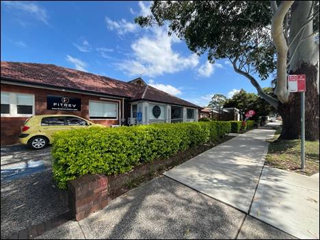
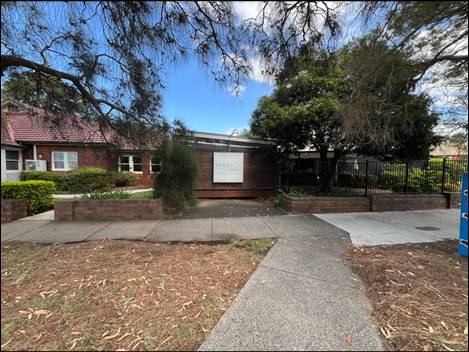
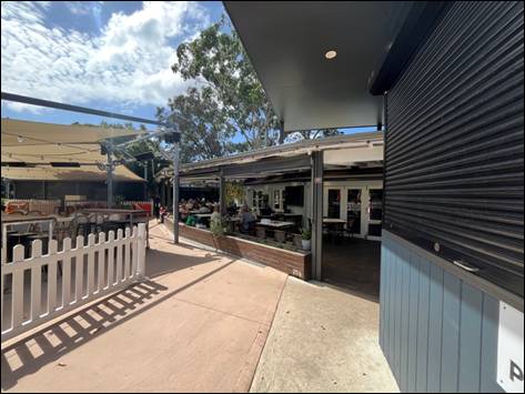
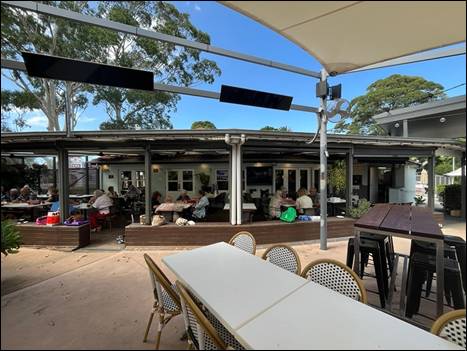
The site is developed with a single storey building occupied by the Longueville Sporting Club, ancillary pizza oven, outdoor seating area, and bowling green – refer to Photos 1-5. The Longueville Sporting Club traverses the boundary of No. 245 Longueville Road, owned by the Council, which includes Central Park, and Lane Cove Tennis Club operated courts. The proposed improvements relate to No. 243 Longueville Road only. |
|
Shape |
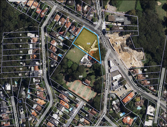
The site has an irregular shape and is located at the junction of River Road West, Northwood Road, Longueville Road and Kenneth Streets – refer to Figure 1. |
|
Dimensions |
Northern boundary dimension of 39.55m Combined eastern boundary dimensions of 68.82m Southern boundary dimension of 79.07m Western boundary dimension of 49.03m |
|
Adjoining properties |
To the north and west the site adjoins low density residential development along River Road West and some commercial development along Longueville Road. To the east across Longueville Road the site adjoins Pathways Longueville a residential aged care community and to the south the side adjoins the Lane Cove Tennis Club at No. 245 Longueville Road. |

(a) Figure 1: Aerial locality plan of No. 243 Longueville Road

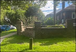
(b) Photo 1: The subject site on the left as viewed from Kenneth Street looking north


![]() |
Photo 2: The Diddy with location of works outlined in red
![]() |

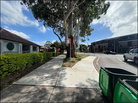
Photo 3: Existing Kenneth Street elevation

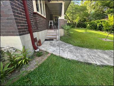
Photo 4: Existing covered open deck / dining area looking east

Photo 5: Existing covered open deck / dining area looking south
SITE APPLICATION HISTORY
|
DA185/2013 |
Extend kitchen, construct deck and alter driveway |
Staff approved on 30/04/2014 |
|
DA185/2013 |
S96 modification of consent – amend plans to include roof over deck |
Staff approved on 15/12/2014 |
|
DA189/2018 |
Modifications to interiors of the Club |
LPP approved on 20/02/2019 |
|
DA189/2018 |
S4.55 Kitchen extension and new shade structure |
Staff approved on 22/09/2020 |
|
DA147/2021 |
Outdoor covered pizza oven |
LPP approved on 03/03/2022 |
|
DA39/2023 |
Extension of existing shade cloth and associated works |
LPP approved on 05/07/2023 |
PROPOSAL
The development application is seeking consent for the enclosure of the existing open verandah and the re-sheeting of the existing verandah roof.
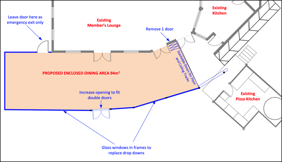
Currently the outdoor dining area, which occupies approximately 94sqm, includes roller blinds along the northern elevation which is proposed to be replaced with glass louvred windows.
In more detail the works include:-
· new glass louvered windows to existing openings;
· remove door within the southwestern corner;
· introduce new stackable door along the western elevation;
· retain southern emergency exit door;
· increase size of existing opening within northern elevation to fit new double doors;
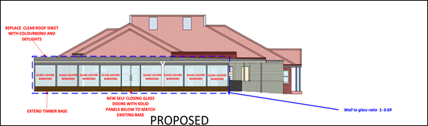
· remove existing clear poly verandah roof, with new colorbond steel roof;
· introduce 6 new round skylights;
· extend timber base; and
· additional timber slates on external eastern elevation.
The proposal seeks to create a more comfortable dining environment during unsuitable weather conditions.

Figure 2: Proposed Floor Plan

Figure 4: Proposed eastern elevation
Assessment - Environmental planning and assessment act 1979
The objects of the Environmental Planning and Assessment Act 1979 are guiding principles that need to be considered by planning authorities when making decisions under the Act.
The applicable objects are:-
(a) Promote social and economic welfare and a better environment
(d) Protect the environment, including threatened species and ecological communities
(g) Promote good design, amenity and proper construction
(i) Facilitate ecologically sustainable development (ESD)
(k) Promote the orderly and economic use and development of land
The proposed development is consistent with these objects because it:-
· Enhances social and economic welfare by improving community/recreational amenity.
· Preserves environmental and biodiversity values by limiting works to already-developed areas.
· Maintains good design and amenity standards, ensuring compatibility with the locality.
· Supports ecologically sustainable development through ventilation and minor energy-efficient improvements.
· Represents an orderly, minor improvement to an existing facility, ensuring efficient and appropriate use of the land.
provisions of any lep, dcp, SEPP or regulation (Section 4.15(1)(a))
The proposal is permissible and does not raise any issues in regard to the Lane Cove Local Environmental Plan 2009 – refer to Section 4.15 Assessment of this report below.
Other Planning Instruments
SEPP (Resilience and Hazards) 2021
Chapter 4 - Remediation of land
Chapter 4 of Resilience and Hazards SEPP aims to ‘provide a State-wide planning approach to the remediation of contaminated land’. Clause 4.6 requires a consent authority to consider whether the land is contaminated and if it is suitable or can be remediated to be made suitable for the proposed development, prior to the granting of development consent.
The subject site has been used continuously for recreational purposes for a number of years. Given this ongoing use, it is unlikely that the site is contaminated.
SEPp (Biodiversity and Conservation) 2021
The two relevant chapters are addressed under the following subheadings.
Chapter 2 Vegetation in non-rural areas
The aims of Chapter 2 have been satisfied as the proposed development would have no adverse impact on the biodiversity value of trees and other vegetation.
The application does not seek to remove any trees or existing landscape areas; however, the proposed works are located in close proximity to an existing tree which will requires some pruning.
Council’s tree preservation officer raised no objection subject to detailed pruning as a condition of consent, along with appropriate tree protection measures.
Chapter 6 Water
catchments
The site is located within the Sydney Harbour Catchment. The proposed works are minor in nature and include appropriate stormwater management measures. The development will not result in any adverse impact on water quality entering the catchment and is consistent with the aims of this chapter.
SECTION 4.15 ASSESSMENT
The following assessment is provided against the relevant provisions of Section 4.15 of the Environmental Planning and Assessment Act, 1979:
Lane Cove Local Environmental Plan 2009
Aims of Plan
The proposed development is considered to be consistent with the aims of the Lane Cove Local Environmental Plan 2009, as outlined under Clause 1.2(2). In particular, the proposal supports the environmental, social and economic sustainability of the locality in accordance with Clause 1.2(2)(a), maintains the existing character and amenity of the site consistent with Clause 1.2(2)(b), and contributes to the ongoing provision and improvement of community and recreational facilities in accordance with Clause 1.2(2)(g). The development is of a minor scale, will not adversely impact the natural environment or surrounding locality, and is compatible with the existing use of the land. Accordingly, the proposal is considered to achieve the relevant aims of the Plan.
|
Zoning: |
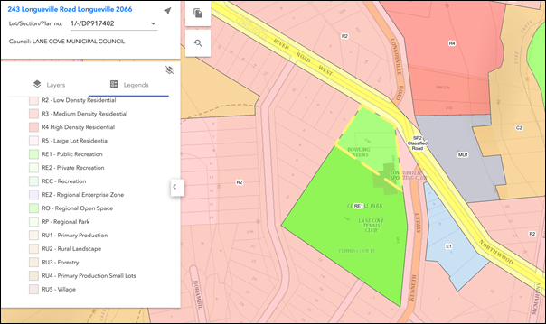
The subject site is zone RE1 Public Recreation – see Figure 5.
The proposed development is consistent with the zone objectives in that: · the public recreation use is maintained with the development being ancillary to the existing Longueville Sporting Club and does not alter the primary recreational use of the site. · it supports recreational activities with the enclosure of the verandah improving usability in adverse weather, enhancing functionality and patron amenity year-round. · the works are minor in scale and remain consistent with the existing recreational setting, introducing no incompatible land uses. · the proposal is confined to an existing developed area, with operable louvre windows maintaining ventilation and visual connection to the surrounding bowling greens, retaining the open space character. |
|
Permissibility: |
The proposed development forms part of the continued use of the Longueville Sports Club as a community facility, recreation facility (outdoor) and restaurant, all of which are permissible with consent in the RE1 Public Recreation zone. |

Figure 5: RE1 Zoning Map
The table below demonstrates consistency with the LCLEP 2009.
|
LCLEP 2009 TABLE |
|||
|
Clause |
Development Standard |
Proposal |
Complies |
|
Clause 4.3 Height of Buildings (max) |
The subject site does not include a maximum height on the height of building map |
The proposal does not alter the existing verandah height |
N/A |
|
Clause 4.4. Floor Space Ratio (max) |
The subject site does not include a maximum FSR on the FSR map |
N/A |
N/A |
|
Clause 5.10 Heritage Conservation |
The subject site does not include a heritage item nor is it located within a heritage conservation area |
N/A |
N/A |
|
Clause 5.21 Flood Planning |
The subject site is not identified as flood prone land |
N/A |
N/A |
|
Clause 6.1 Acid sulfate soils |
The subject site does not contain acid sulfate soils |
N/A |
N/A |
|
Clause 6.1A Earthworks |
|
No earthworks proposed |
N/A |
Lane Cove Development Control Plan 2009
There are no applicable numerical controls under LCDCP 2009. As such a merit-based assessment is applied, as follows:
· The proposal is consistent with the relevant objectives of the Lane Cove Development Control Plan (Clause 1.1) for the following reasons:
o The development supports environmental, social and economic sustainability by improving the functionality and amenity of an existing community/recreational facility for patrons, enabling its continued and efficient use.
o The design and scale of the works are sympathetic to the existing built form and will not detract from the visual quality of the site or its relationship with the surrounding public domain.
o The enclosure of the existing verandah provides improved weather protection and enhances user comfort, without resulting in any adverse impacts on the character or amenity of the locality.
· The proposal does not involve any tree removal however it is within 4m of an existing tree. Some pruning may be required during construction and Councils tree preservation officer raised no concerns subject to conditions of consent.
· The proposal has been skillfully designed to be integrated with the existing structure.
· The proposal is not considered to give rise to any adverse environmental impacts to surrounding development.
· The site is located on a corner allotment with the works not alerting the existing setbacks.
· The proposed enclosure of the existing verandah with glass louvres does not alter the existing building envelope resulting in no change to the existing bulk and scale.
· No additional seating or restaurant capacity is sought as part of this application.
· The enclosure of the verandah with glass louvres will enhance the amenity of an existing outdoor area, used by the sporting club and restaurant.
· The proposal is not considered to generate any additional noise impact beyond the existing facilities.
Therefore, the proposal is acceptable on merit.
Part B – General Controls
The compliance report accompanying the application demonstrates the application is capable of compliance with the provisions of Section J (Energy Efficiency) of the Building Code of Australia (Including NSW Schedule 5).
The report identifies the requirements for the development to achieve compliance with Building Code of Australia.
Part J - Landscaping and Tree Preservation
The application does not seek to remove any trees or existing landscape areas; however, the proposed works are located in close proximity to an existing tree.
It is unlikely that the proposed works will increase or alter the existing encroachment within the TPZ or SRZ. Notwithstanding this, the installation of the new roof may require minor pruning of some existing branches that currently make contact with the roof.
Council’s Tree Preservation Officer raised no concerns in this respect, subject to conditions of consent.
Part O: Stormwater Management
A drainage plan has not been submitted with the DA. Stormwater will continue to connect to existing downpipes and be dispersed as per the existing situation. Council’s Development Engineer raised no concerns in this respect, subject to conditions of consent.
Part Q: Waste Management and Minimisation
A Waste Management Form accompanied the application and a standard condition of consent is included.
Community Land Plan of Management (Adopted 21 October 2019)
The Lane Cove Council Community Land Plan of Management covers management of Central Park, which includes Nos. 243 and 245 Longueville Road, owned by Lane Cove Council. The site is categorised within the Plan of Management as ‘general community use’.
The proposal is consistent with the objectives, land use and desired outcomes of the Plan of Management as it allows for the continued and well-managed use of the site for a community purpose associated with the Longueville Sporting Club that is compatible with adjoining land uses.
REFERRALS
Development Engineer – Part O – Stormwater Management
Council’s Development Engineer raised no objections subject to recommended conditions.
Tree Preservation Officer
Council’s Tree Preservation Officer noted that the proposed enclosure of the existing verandah and re-sheeting of the roof does not necessitate the removal of any trees. However, the site inspection identified that minor building clearance pruning will be required, as the canopy of an Acmena smithii (Magenta Lilly Pilly) located on the site’s eastern boundary adjacent to the structure is currently in conflict with the building.
No objection is raised subject to detailed pruning specification as a condition of consent, along with appropriate tree protection measures.
APPLICABLE REGULATIONS
Section 61(1) of the Environmental Planning and Assessment Regulation 2021 requires the consent authority to consider compliance with AS 2601-2001: The Demolition of Structures. A condition of consent seeking compliance with this Standard is recommended.
IMPACTS OF DEVELOPMENT (Section 4.15(1)(b))
The impacts of the development have been considered. The proposal is not considered to give rise to any adverse environmental, social or economic impacts.
SUITABILITY OF SITE (Section 4.15(1)(c))
The proposed development is suitable for the site as the proposed development is permissible within the Zone. The proposed development will improve the amenity of the existing community facility for club members and members of the public.
RESPONSE TO NOTIFICATION (Section 4.15(1)(d))
The application was notified in accordance with Council’s Notification Policy from 18 February 2026 to 18 March 2026. No submissions were received.
PUBLIC INTEREST (Section 4.15(1)(e))
The proposed development would have no adverse impacts on neighbouring properties and the public domain with regard to the Lane Cove LEP 2009, Lane Cove DCP 2009 and the relevant environmental planning instruments. Therefore, approval of this application would not be contrary to the public interest.
CONCLUSION
The matters in relation to Section 4.15 of the Environmental Planning and Assessment Act 1979 have been satisfied.
The application is acceptable having regard for the Lane Cove LEP 2009; the Lane Cove DCP 2010 and the Lane Cove Community Land Plan of Management 2019. The proposal will improve the amenity of an existing community facility for patrons.
On balance as the proposed development would be reasonable it is therefore recommended for approval.
|
RECOMMENDATION
That pursuant to Section 4.16(1) of the Environmental Planning and Assessment Act, 1979 the Lane Cove Local Planning Panel at its meeting of 15 April 2026, exercising the functions of Council as the consent authority, and grant consent to Development Application 04/2026 for the enclosure of the existing rear open verandah and re-sheeting of the existing verandah roof to the Longueville Sporting Club located at No. 243 Longueville Road, Longueville, subject to the following conditions of consent:-
PART A – GENERAL CONDITIONS
1. A.1 - Approved plans Development must be carried out in accordance with the following approved plans (stamped by Council), except where the conditions of this consent expressly require otherwise.
In the event of any inconsistency between the approved plans and a condition of this consent, the condition prevails.
Reason: To ensure all parties are aware of the approved plans and supporting documentation that apply to the development.
2. A.3 - Payment of security deposits Before the commencement of any works on the site, or the issue of a construction certificate, the applicant must make the following payment to Council and provide written evidence of this payment to the Principal certifier:
To make this payment contact Lane Cove Customer Service Team.
The mode of payment shall only be non-cash payments (Credit card, Bank cheque, EFT) or Bank Guarantee lodged with Council.
The payment will be used for the cost of: · making good any damage caused to any council property (including street trees) as a consequence of carrying out the works to which the consent relates, and · completing any public work such as roadwork, kerbing and guttering, footway construction, stormwater drainage and environmental controls, required in connection with this consent.
Reason: To ensure any damage to public infrastructure is rectified and public works can be completed.
3. A.7.L - Tree preservation
The following trees shall be retained:
This consent gives approval to carry out the following works in a Tree Protection Zone:
Advisory Note: The protection of trees in Lane Cove is regulated under State Environmental Planning Policy (Biodiversity and Conservation) 2021 (SEPP) parts 2.2 and 2.3 which prohibit the clearing of vegetation without the authority conferred by a permit granted by Council. Clearing under the SEPP is defined as: a) cut down, fell, uproot, kill, poison, ringbark, burn or otherwise destroy the vegetation, or (b) lop or otherwise remove a substantial part of the vegetation. The clearing of trees or vegetation protected by this SEPP is an offence against the Environmental Planning and Assessment Act 1979 (NSW). The maximum penalty that may be imposed in respect to any such offence is $1,100,000 per individual and $5,500,000 per corporation. Reason: To ensure the protection of trees to be retained and to confirm trees for pruning/removal.
4. A.9.T - Works on Council land A separate application shall be made to Council’s Open Space and Infrastructure Division for any associated works on Council property. Written approval is to be obtained prior to the start of any works on Council property.
Where the applicant requires the use of construction plant on the public road reservation, an “Application for Standing Plant Permit” shall be made to Council. Applications shall be submitted and approved prior to the start of any related works. Note: allow 2 working days for approval.
Reason: To manage impacts to Council’s assets.
5. A.12 – Construction Certificate The submission of a Construction Certificate and its issue by Council or principal certifier PRIOR TO CONSTRUCTION WORK commencing.
Reason: To ensures the detailed construction plans and specifications comply with the requirements of the Building Code of Australia (BCA) and any relevant Australian Standard.
PART B – PRIOR TO DEMOLITION WORKS
6. B.2.E Asbestos removal, handling and disposal The removal, handling and disposal of asbestos from building sites shall be carried out in accordance with the requirements of the Occupational Health and Safety Act and the Regulations. Details of the method of removal in accordance with this condition is to be submitted to the Principal Certifying Authority and Council’s Environmental Health Section, prior to commencing any demolition works.
Reason: To ensure worker and public health and safety.
7. B.3.EH - Compliance with demolition standard Demolition of buildings and structures must comply with Australian Standard AS 2601—2001: The Demolition of Structures.
Reason: Prescribed condition under the EP&A Regulation 2021.
8. B.14 - Special Condition - Tree Protection Measures Tree protection measures for the Acmena smithii (Magenta Lilly Pilly) located on this site’s eastern boundary adjacent to the verandah structure must be in place prior to the commencement of any works, and certified by an Australian Qualification Framework (AQF) Level 5 Arborist.
1. Where tree protection fencing is used. the fencing must consist of a 1.8 m high chain mesh fence held in place with concrete block footings and fastened together. An example of fencing is shown under figure 4 on page 18 of the Australian Standard 4970-2025 Protection of trees on development sites.
2. The fenced area shall not be used for the storage of building materials, machinery, site sheds, or for advertising and the soil levels within the fenced area shall remain undisturbed.
3. A waterproof sign must be placed on every second panel stating, ‘NO ENTRY TREE PROTECTION AREA – this fence and sign are not to be removed or relocated for the work duration.’ Minimum size of the sign is to be A3 portrait with NO ENTRY TREE PROTECTION ZONE in capital Arial Font size 100, and the rest of the text in Arial font size 65.
4. Where Trunk protection is specified, the trunks of the trees must be protected during the construction period by a trunk guard that consists of the following:
· timber planks (50mmx100mm or similar) shall be placed at 100mm intervals and must be fixed by wire ties or strapping to a height of 2m. 1. · hessian cloth is to be placed between the trunk and the planks to minimise damage. The timber planks are not to be fixed directly to the tree in any way.
An example of suitable trunk protection can be found under figure 5 on page 20 within the Australian Standard 4970-2025 Protection of trees on development sites.
5. A waterproof sign must be placed on every second panel stating, ‘NO ENTRY TREE PROTECTION AREA – this fence and sign are not to be removed or relocated for the work duration.’ Minimum size of the sign is to be A3 portrait with NO ENTRY TREE PROTECTION ZONE in capital Arial Font size 100, and the rest of the text in Arial font size 65.
6. Tree Protection fencing/trunk protection and signage must be erected prior to works commencing and remain in place for the duration of the construction work.
7. Any movement of Tree Protection Fencing must be overseen and approved by an AQF Level 5 Arborist.
Reason: To protect the natural environment
PART C - BEFORE THE ISSUE OF A CONSTRUCTION CERTIFICATE
9. C.1 - Construction site management plan
Prior to any demolition works and before the issue of a construction certificate, the applicant must ensure a construction site management plan is prepared before it is provided to and approved by the principal certifier. The plan must include the following matters: · before the commencement of any works, a safety barrier or temporary fencing is to be provided along the full frontage of the property. · the location and materials for protective fencing. · provisions for public safety · pedestrian access, including disabled and pram access, is to be maintained throughout the course of the construction as per AS-1742.3, ’Part 3 - Traffic control devices for works on roads’. · pedestrian and vehicular site access points and construction activity zones · the location of site storage areas and sheds · equipment used to carry out all works · a garbage container with a tight-fitting lid
The applicant must ensure a copy of the approved construction site management plan is kept on-site at all times during construction.
Council approval
Any construction plant on the public road reservation requires an approved “Application for standing plant permit”.
Reason: To require details of measures that will protect the public, and the surrounding environment, during site works and construction.
10. C.2 - Erosion and sediment control plan Prior to any demolition works or clearing of any vegetation and before the issue of a construction certificate, the applicant is to ensure that an erosion and sediment control plan is prepared in accordance with the following documents before it is provided to and approved by the principal certifier: · the Lane Cove DCP 2009, · the guidelines set out in the NSW Department of Housing manual ‘Managing Urban Stormwater: Soils and Construction Certificate’ (the Blue Book), and · the ‘Do it Right On-Site, Soil and Water Management for the Construction Industry' (Southern Sydney Regional Organisation of Councils and the Natural Heritage Trust). The applicant must ensure the erosion and sediment control plan is kept on- site at all times during site works and construction.
Reason: To ensure runoff and site debris do not impact local stormwater systems and waterways.
PART D - BEFORE THE COMMENCEMENT OF BUILDING WORK
11. D.1 - Erosion and sediment controls in place Before the commencement of any site or building work, the principal certifier must be satisfied the erosion and sediment controls in the erosion and sediment control plan, (as approved by the principal certifier) are in place until the site is rectified (at least 70% ground cover is achieved over any bare ground on the site).
Reason: To ensure runoff and site debris do not impact local stormwater systems and waterways.
12. D.3 - Signs on site A sign must be erected in a prominent position on any site on which building work or demolition work is being carried out: a) showing the name, address and telephone number of the principal certifier for the work; and b) showing the name of the principal contractor (if any) for any building work and a telephone number on which that person may be contacted outside working hours; and c) stating that unauthorised entry to the work site is prohibited.
Any such sign is to be maintained while any demolition or building work is being carried out but must be removed when these works have been completed.
Note: This does not apply in relation to building work, or demolition work, that is carried out inside an existing building that does not affect the external walls of the building.
Reason: Prescribed condition under section 70 of the EP&A Regulation 2021.
PART E - WHILE BUILDING WORK IS BEING CARRIED OUT
13. E.1.A - Hours of Work The principal certifier must ensure that building work, demolition or vegetation removal is only carried out between:
Monday to Friday (inclusive) 7.00am to 5.30pm Saturday 7.00am to 4.00pm
With NO high noise generating activities, to be undertaken after 12 Noon on Saturday.
A Notice/Sign showing permitted working hours and types of work permitted during those hours, including the applicant’s phone number, the phone number of the Project Manager or Site Foreman, shall be displayed at the front of the site.
The principal certifier must ensure building work, demolition or vegetation removal is not carried out on Sundays and public holidays, except where there is an emergency.
Reason: To protect the amenity of the surrounding area.
14. E.2 - Compliance with the Building Code of Australia Building work must be carried out in accordance with the requirements of the Building Code of Australia.
Reason: Prescribed condition under section 69 of the EP&A Regulation 2021.
15. E.7 - Construction noise
While building work is being carried out and where no noise and vibration management plan is approved under this consent, the applicant is to ensure that any noise caused by demolition, vegetation removal or construction does not exceed an LAeq (15 min) of 5dB(A) above background noise, when measured at any lot boundary of the property where the construction is being carried out.
Reason: To protect the amenity of the neighbourhood.
16. E.15.B - Critical stage inspections Critical stage inspections are to be carried out in accordance with Section 6.5 of the EP&A Act 1979 and clauses 162A, 162B and 163 of the EP&A Regulation 2000. Where Lane Cove Council is appointed as the PCA, an inspection is to be booked for each of the following relevant stages during the construction process:
a) any footings; b) any structural steelwork; c) any floor and roof framing; and d) as requested by the Council.
Reason: EP&A Act requirement.
17. E.18.B - No obstruction of public way The public way and Council verge must not be obstructed by any materials, vehicles, refuse, skips or the like, under any circumstances. Non-compliance with this requirement will result in the issue of a notice by Council to stop all work on site.
Reason: To ensure public safety.
18. E.25 – Stockpiling of Materials No stockpiling of materials, building equipment or additional activities listed in section 4.2 of AS4970-2009 Protection of trees on development sites is to occur within designated tree protection areas or on the Council owned nature strip. All building materials must be stored within the subject site.
Reason: To mitigate damage to Council land.
19. E.27– Tree Pruning. Council grants consent for the pruning of Acmena smithii (Magenta Lilly Pilly) located on the eastern boundary adjacent to the verandah structure
Selectively prune to increase clearance from the awning for construction. Remove 1 x ascending S 3rd order. Final Cut 130mm. Remove 2 x lateral S 5th order branches. Final cuts 60-90mm diameter.
All pruning works must be done in accordance with AS4373-2007 The Pruning of Amenity Trees. All branches must be pruned to branch collars to the specified branch diameters listed above.
All pruning works may only be undertaken upon the issue of a construction certificate. Pruning outside of the authorised works will result in regulatory action.
Reason: To provide appropriate building clearances whilst maintaining the health and aesthetics of trees.
PART F - BEFORE THE ISSUE OF AN OCCUPATION CERTIFICATE
20. F.1 - Works-as-executed plans and any other documentary evidence Before the issue of the relevant occupation certificate, the applicant must submit, to the satisfaction of the principal certifier, works-as-executed plans, any compliance certificates and any other evidence confirming the following completed works:
(a) The stormwater from new roof/impervious area is connected to existing drainage system. In this case, a Hydraulic Engineer’s, or qualified Plumber’s certificate is required that the existing drainage system is in good working condition and satisfies Part O - Stormwater Management of the Lane Cove Council Development Control Plan 2009 for the proposed addition of stormwater.
(b) Certification from a suitable licenced contractor that all works then have been constructed satisfy the relevant Australian standards.
The principal certifier must provide a copy of the plans to Council with the occupation certificate.
Reason: To confirm that the proposed works have been constructed satisfactorily as per the approved plans.
PART H - OCCUPATION AND ONGOING USE
21. H.1 - Release of securities bonds When Council receives an occupation certificate from the principal certifier, the applicant may lodge an application to release the securities held in accordance with condition A.3. Council may use part, or all of the securities held to complete the works to its satisfaction if the works do not meet Council’s requirements.
Reason: To allow for the release of securities, and to authorise Council to use the security deposit to complete works to its satisfaction.
|
||||||||||||||||||||||||||||||||||||||||||||||
|
|
Mark Brisby
Director - Planning and Sustainability
Planning and Sustainability Division